
21 September 2018
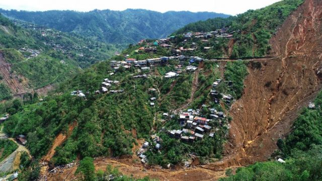
The enormous mining-induced Naga City landslide in Cebu, the Philippines
The enormous mining-induced Naga City landslide in Cebu, the Philippines
Yesterday an enormous landslide occurred at Naga City in Cebu, the Philippines. This was an extraordinary event, without doubt one of the largest mining-induced landslides in recent years. Whilst it has garnered very little publicity outside the Philippines, this was an unusual landslide:-
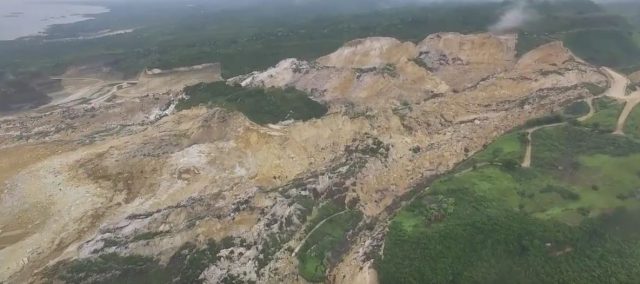
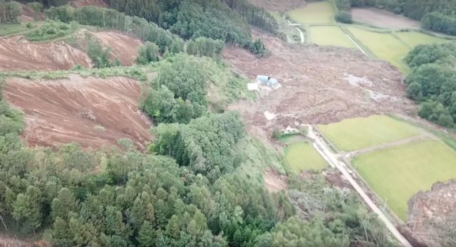
The Naga City landslide in the Philippines. Image via Youtube
.
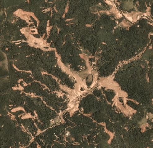
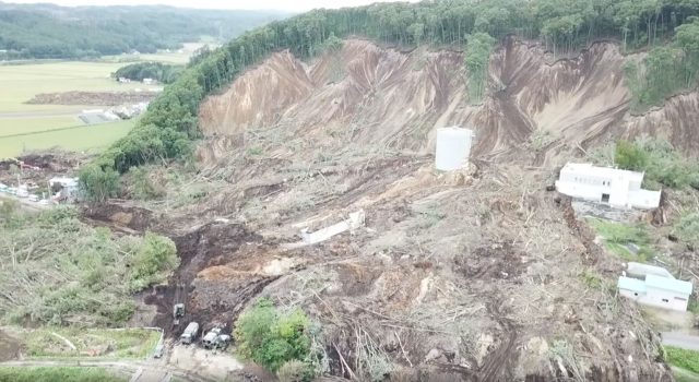
Asian Policy Press has an excellent gallery of images, including this one:-
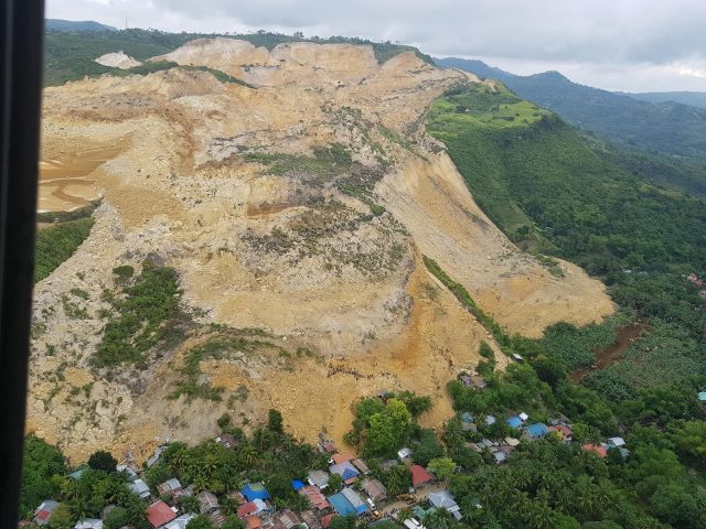
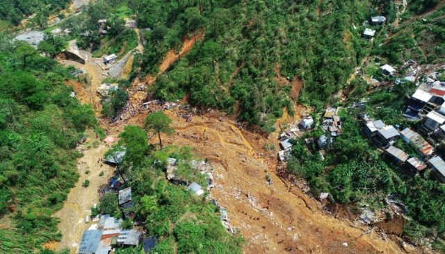
Overview of the Naga City landslide. Image via Asian Policy Press.
.
As the image above shows, the margins of the landslide buried houses built around the quarry. To date it has been confirmed that 21 people were killed; a further 74 are reported to be missing.
There is an interesting video on Youtube showing the landslide. The first part appears to have been shot ahead of the failure, and highlights multiple tension cracks, some looking very fresh. The images appear to correspond to the landscape of the failed area, and the shots that include the quarry are credible, although I cannot guarantee that they are from the same site. The second part shows grainy but amazing footage of the landslide in motion. The third part shows the aftermath of the landslide, shot from the air.
<a href="https://blogs.agu.org/landslideblog/2018/09/18/barangay-ucab-landslide/">http://www.youtube.com/watch?v=Tgg2umsWDH8</a>.
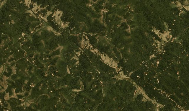
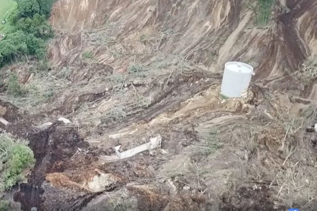
Google Earth has good imagery of the site of the landslide, taken in 2017:-
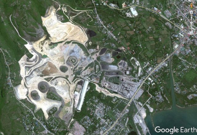
Google Earth imagery of the site of the Naga City landslide.
.
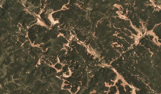
Whilst Planet Labs have an image captured yesterday after the landslide:-
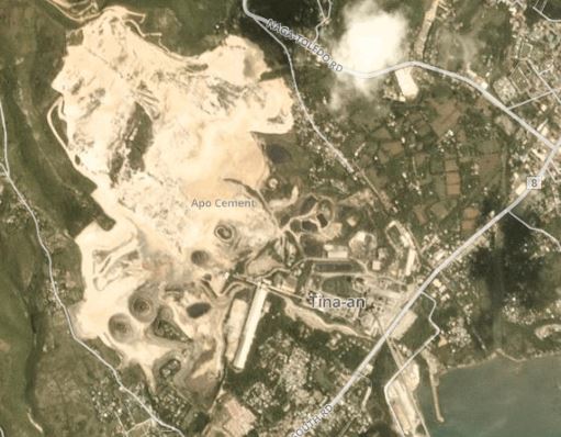
Planet Labs PlanetScope image showing the aftermath of the Naga City landslide. Image collected on 21st September 2018, used with permission.
.
The imagery suggests that there can be little doubt that this slide was associated with the mining activity, although the final trigger may have been rainfall-related. One is left wondering how such a disaster can occur if, as seems to be the case, the hillside was showing multiple signs of distress. This is, of course, the second destructive landslide in the Philippines in a week.
Reference
Planet Team (2018). Planet Application Program Interface: In Space for Life on Earth. San Francisco, CA. https://api.planet.com
19 September 2018
The Kodagu landslides in Karnataka, India: Planet Labs imagery
Kodagu landslides in Karnataka, India: Planet Labs imagery
On 15th to 17th August, the Kodagu area of Karnataka in SW India suffered exceptional monsoon rainfall, inducing floods and landslides. Reports suggest that over 200 mm fell per day on three successive days. There were many fatalities and a high level of damage was inflicted. There has been considerable controversy in India as to the cause of the Kodagu landslides, with suggestions ranging from environmental degradation, release of water from a network of dams and even a previous earthquake. A team has been established to examine the causes; it will be interesting to see what they find.
These landslides received comparatively little attention in outside of India, but they were a very substantial event. Raj Bhagat P and Samrat Basak from WRI India, used Copernicus Sentinel data to examine the impact of the landslides.The Planet Labs image below shows the heart of the area affected by the landslides, prior to the event (image from 11th May 2018) – this is an area of forest with some human modification for farms and roads. It is hilly, but not mountainous:-
Pre-event Planet Labs imagery of the area affected by the Kodagu landslides in SW India in mid-August. Image courtesy of Planet Labs, used with permission. 4-band PlanetScope scene dated 11th May 2018.
.
Compare that with the PlanetLabs image below, collected on 15th September 2018:-
Post-event Planet Labs imagery of the area affected by the Kodagu landslides in SW India in mid-August. Image courtesy of Planet Labs, used with permission. 4-band PlanetScope scene dated 15th September 2018
.
The difference is dramatic – it is clear that many landslides were triggered across this area. These look to be shallow slides that have transitioned into channelised flows. In many cases multiple landslides have coalesced into the same channel. The area below is such an example:-
Detailed post-event Planet Labs imagery of the area affected by the Kodagu landslides in SW India in mid-August. Image courtesy of Planet Labs, used with permission. 4-band PlanetScope scene dated 15th September 2018
.
Each of the channels here has been fed by multiple smaller landslides, forming very dramatic channelised flows. There is extensive sediment deposition on the valley floor, which will have been disastrous for the farmers in this area. The reports of the loss of infrastructure is explained, at least in part, by the extremely damaging effects of these flows.
Acknowledgement and Reference
Kishor Cariappa first highlighted the extensive nature of these landslides, as evidenced by satellite imagery, on the website Kodagu Connect. Interpretation of satellite images of this event was first undertaken by WRI India, using modified Copernicus Sentinel data [2018]; Processed by Raj Bhagat P, Samrat Basak.
Planet Team (2018). Planet Application Program Interface: In Space for Life on Earth. San Francisco, CA. https://api.planet.com
18 September 2018
Drone images of the Barangay Ucab landslide
Drone images of the Barangay Ucab landslide
The loss of life from the Barangay Ucab landslide has now reached 54 people; the search for victims continues. There is now agreement that there is no possibility of further survivors. Sadly, it is thought that 42 people remain missing, potentially making this one of the most deadly landslides of the year to date.
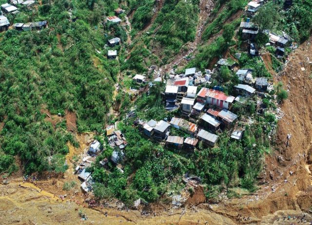
On Twitter, Mohammed Abdiker (Director of Operations and Emergencies at the International Organization for Migration – the UN migration agency) has posted a set of images collected by drone of the Barangay Ucab landslide. These reveal for the first time the nature of the landslide:-
The Barangay Ucab landslide in the Philippines. Drone image posted to Twitter by Mohammed Abdiker.
.
This image shows that the landslide was a large, comparatively deep-seated slide in deeply weathered regolith. It appears to me that the slide transitioned into a channelised flow once it reached the channel; it is this flow that appears to have destroyed the accommodation block. This image shows the channel downstream of the landslide source, including some of the destroyed structures:-
The lower reaches of the Barangay Ucab landslide in the Philippines. Drone image posted to Twitter by Mohammed Abdiker.
.
Notably, most of the debris appears to have left the channel and entered the main river. This may explain why so many victims have not been recovered as yet. The image below shows the channel in more detail. Note the people for scale – this provides a sense of the magnitude of this landslide. The vulnerability of the buildings is also clear, as is the presence of many other landslides in addition to the one that caused such high loss of life:-
The scale of destruction at the Barangay Ucab landslide in the Philippines. Drone image posted to Twitter by Mohammed Abdiker.
.
In terms of the cause of the landslide, I suspect that the investigation might like to look carefully at the road that crosses the slide. This part of the first image provides more detail:-
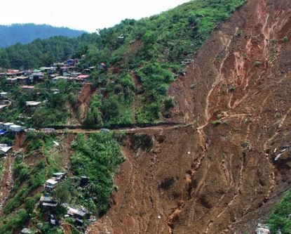
Further detail of the Barangay Ucab landslide in the Philippines. Drone image posted to Twitter by Mohammed Abdiker.
.
The intact section of road suggests deep undercutting of the hillslope, with no apparent slope protection. We have previously seen a failure mechanism in which such road cuts destabilise the upper portion of the slope (NB PDF), which loads the lower portion, triggering large-scale failure that transitions into a flow. To verify this requires further investigation, and there may be other explanations, but it would be a good initial working hypothesis.
Such unplanned road cutting is rampant in mountain areas around the world; it inflicts a huge cost on these communities, and on the environment.
17 September 2018
Barangay Ucab: many dead after typhoon Mangkhut in the Philippines
Barangay Ucab: many dead after Typhoon Mangkhut in the Philippines
As expected, Typhoon Mangkhut (known locally at Typhoon Ompong) triggered many landslides along its track as it passed across the Philippines this weekend. The most serious incident appears to have occurred in Barangay Ucab in Benguet province. At this location a large landslide has buried the living quarters housing up to 100 miners; the picture is slightly unclear as to how many have lost their lives, but to date at least 33 bodies have been recovered. The recovery operations are being hampered by many other landslides in this area.
The best image that I have found so far is this one, which appears to show the crushed buildings:-

Crushed buildings, possibly from a landslide at Barangay Ucab, triggered by Typhoon Mangkhut in the Philippines. Image via ABS CBN News.
.
ABS CBN News note that this landslide occurred in a mining area that had been abandoned in 2009 “after an accident”, although it is not clear what this might have been. Melanie Froude and I noted in our recent paper (Froude and Petley 2018) that landslides associated with illegal mining are on the increase globally; this appears to be another tragic example. The same article also suggests that there had been attempts to evacuate the site prior to the slide:
“They thought their area was safe so they turned it into an evacuation center by themselves. We did not allow them to do so, but they threatened to fight us off so our policemen were forced to just leave”
But this landslide at Barangay Ucab is by no means the only landslide event to have caused loss of life in the Philippines. So far there is no detailed itemisation of the losses (this will be available in due course), but there are reports of many other, smaller landslides. Meanwhile, the true impact of the storm in southern China is yet to become clear.
Reference
Froude, M. J. and Petley, D. N. 2018. Global fatal landslide occurrence from 2004 to 2016. Natural Hazards and Earth System Sciences, 18, 2161-2181, https://doi.org/10.5194/nhess-18-2161-2018.
13 September 2018
Typhoon Mangkhut, Hurricane Florence and the earthquake in Hokkaido
Typhoon Mangkhut, Hurricane Florence and the earthquake in Hokkaido
We seem to be in one of those periods in which there are multiple potential landslide events occurring in a short period. The two currently active, landfalling major, tropical cyclones, Typhoon Mangkhut and Hurricane Florence, both have the potential to be very major landslide-generating events. Of these, and contrary to the focus of the media attention, the most worrying is Typhoon Mangkhut, a formidable storm in every respect. Its projected track across the Philippines overnight on Friday, and then its landfall in mainland China over the weekend, have the potential to cause enormous damages. I am reminded for example of the effects of Typhoon Parma (Peping) in 2009, which triggered landslides that killed hundreds of people.
Meanwhile, Hurricane Florence, although downgraded in the (very one-dimensional) international classification, is also capable of generating substantial numbers of landslides. As I have noted previously, whilst the media likes to focus on the wind, a large part of tropical cyclone damage is usually related to water (storm surge, inland flooding, rainfall triggered landslides). If the storm stalls (and at the time of writing the forecast is that it will do exactly that) then the rainfall impacts will rapidly multiply. In this situation we will probably see extensive landsliding in North and South Carolina. Let’s hope that the storm keeps moving.
The worse case of a stalled tropical cyclone I have seen was Typhoon Morakot in 2009 in Taiwan. Taiwan is a more hazard prone environment than the USA, so we would not expect a repeat on that scale, but the ability of such systems to generate truly epic volumes of rainfall is clear.
And last but not least, the nature and range of landslides triggered by the 2018 Hokkaido Eastern Iburi Earthquake are becoming clearer. Planet Labs have been seeking to collect high resolution imagery using the SkySat system, and have had some success in the last couple of days:-
Planet Labs SkySat image of the landslides from the 2018 Hokkaido Eastern Iburi Earthquake. Image used with permission.
.
Meanwhile, Google earth have published Digital Globe imagery via Google Earth (this link will download the kml file). We are truly in an amazing time; with multiple imagery systems working in parallel, we can capture high quality imagery soon after these events even in cloudy environments. Planet Labs have plans to launch many more satellites in the years ahead, and there are many other providers with ambitious plans too, so this capability will grow.
And, of course, a simple exploration of these satellite images from Hokkaido leaves one astounded by the landslides that this event triggered.
Of the 41 people killed in this earthquake, 36 died in landslides in the Atsuma area. Most of the victims were older than 60 years; most died because the landslides buried them in their homes. It seems increasingly likely that the landslides occurred in a drape of volcanic materials lying over more competent bedrock. This article explores why these landslides might have been triggered in such large numbers in this area; I continue to suspect that liquefaction of saturated layers after the typhoon may have been a key factor. The local mayor explains how the location of the houses had been selected in light of a variety of hazards, including flooding and the impact of mountain winds. Of course, with hindsight it is easy to say that earthquake triggered landslides were not considered adequately. But in multi-hazard scenarios these things are always obvious after the event, but anticipation is very challenging.
Typhoon Mangkhut is the perfect example. I anticipate that we may see very substantive impacts in the Philippines, but at this point there are so many possible outcomes that it is impossible to know with any certainty.
Reference
Planet Team (2018). Planet Application Program Interface: In Space for Life on Earth. San Francisco, CA. https://api.planet.com
11 September 2018
Drone footage of landslides from the 2018 Hokkaido Eastern Iburi earthquake
Drone footage of landslides from the 2018 Hokkaido Eastern Iburi earthquake
The Mw=6.6 earthquake last week in Japan is now known as the 2018 Hokkaido Eastern Iburi earthquake. The official death toll stands at 44 people, the vast majority of whom were lost in the large number of landslides that were triggered around the town of Atsuma. On Facebook, Yasuykui Shimizu, a professor at the Hokkiado Universiy Hydraulic Lab, has uploaded three drone videos that show these landslides in detail – they can be accessed from here. These provide a brilliant overview of the nature and scale of these slides. You should be able to view the three videos below (but apologies if the WordPress embed function does not work so well):-
https://www.facebook.com/yasu6888/posts/2021331874593631?__xts__[0]=68.ARCHe7G2nCj6WFvgJ0Jim5Q5zJS2IeV-BWQL4mho51uv3m4X0FPlrcXoFiT6qMevG4onmBv0OBRlIIJoSAx2f7ynUzthVtOi6xnE4R72r_d0zmnYQKhM6alNkL_7f4-6O3l40_csI7065Nb3n2BIE_HUyYxqgJ4H2iP-OaUK-CllpRcttPUCkQ&__tn__=-R
.
These videos provide an interesting insight into the landslides. A few things to note – first, the landslides do indeed start from the ridge tops, or from significant breaks in slope, as I thought would be the case. This is a signature of the effects of topographic amplification of the earthquake shaking – I wonder if we will find that this area was subjected to very high peak ground accelerations?
Second, the landslides appear to primarily involve heavily weathered materials. Take a look at the still below:-
Landslides triggered by the 2018 Hokkaido Eastern Iburi earthquake. Still from a video posted on Facebook by Yasuyuki Shimizu.
.
Note that pumice appears to outcrop at the crown and on the margins of the landslides, but the exposed shear surface appears to be in weathered materials. I am not quite sure how this fits with the theory that these landslides were the result of collapse of pumice layers, but I am no expert in these events (and others certainly are).
Third, the landslides appear to have been quite mobile. In the image above the degree to which they have flowed and spread across the flatlands is clear. This does suggest a fluid state. Note that in the image above there is pooled water on the landslide deposit.
And fourth, the landslides appear to be very shallow, for the most part. The image below is fascinating:-
Landslides triggered by the 2018 Hokkaido Eastern Iburi earthquake. Still from a video posted on Facebook by Yasuyuki Shimizu.
.
This landslide shows all the features noted above (and look at the runout distance across the fields for the landslide in the background on the left hand side). But the really interesting aspect is the silo in the middle of the shot. The landslide has flowed around it, leaving it intact and standing, even though it is at the foot of the slope. This is shown more clearly in the image below – you can even see the “slipstream” of the silo in the deposit downslope of the silo:-
The disruptive effect of a silo on the landslide deposit from the 2018 Hokkaido Eastern Iburi earthquake. Still from a video on Facebook by Yasuyuki Shimizu.
.
I suspect that this can only happen if the landslide is both shallow and very fluid. The silo may also have benefited from the unfailed portion a little way upslope (note the trees on the spur), although that might also ask some interesting questions about cause and effect.
Acknowledgement
Thanks to Sanjay Giri for highlighting this imagery in a comment.
10 September 2018
Frozen debris lobes: an interesting hazard in Alaska
Frozen debris lobes: an interesting hazard in Alaska
The Anchorage Daily News has a nice article about the hazards posed by, and mitigation enacted to deal with, frozen debris lobes on the Dalton Highway in the icy north of Alaska. In this case, the movement of the frozen debris lobes towards the road pose an increasing threat of significant disruption. The Alaska Department of Transportation and Public Facilities has now spent about US$2 million rerouting the highway to manage the hazard for the next few years.
Frozen debris lobes are creeping landslides formed from rocks, soil, vegetation and water. The University of Alaska Fairbanks has a good project site about these landslides; they note that in some cases in the vicinity of the road they are moving at 1.7 cm per day. They include the following cross-section to illustrate the structure of these landslides:-
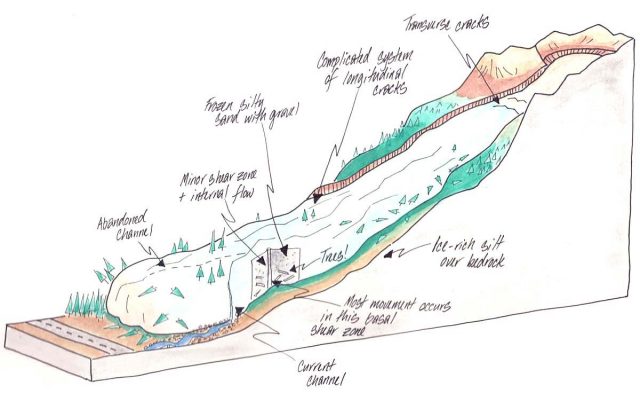
Schematic diagram of a frozen debris lobe. Image by Dan Darrow via the University of Alaska Fairbanks.
.
The concept is that, although these landslides are located in frozen soils, the depth of the slide provides sufficient pressure that liquid water is present at the base. This allows the landslide to creep. Unfortunately, as temperatures warm the availability of water in increasing, so the rate of movement is accelerating.
The University of Alaska Fairbanks team have identified 43 frozen debris lobes, 23 of which are uphill of the highway within 1.6 km of the road. The Google Earth image below shows some of these landslides, including one (known as the blob) that was very close to the highway:-
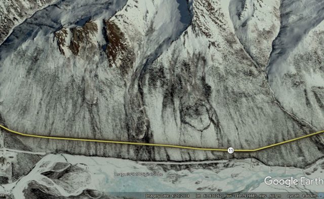
Google Earth imagery of frozen debris lobes above the Dalton Highway in Alaska.
.
The new highway is expected to be safe from the blob for the next 20 years or so. Interesting, the old road has been left in place so the the research team can investigate what happens when the frozen debris lobe starts to overrun it.
6 September 2018
Landslides triggered by the 6th September 2018 Hokkaido earthquake
Landslides triggered by the 6th September 2018 Hokkaido earthquake
There is little doubt now that the major impact of the 6th September 2018 Hokkaido earthquake is in the form of geotechnical failures. Whilst there is abundant evidence of liquefaction, it is the dramatic landslides (some reports suggest about 800 individual events) that have caught the eye and, sadly, caused most of the casualties in all probability. The USGS Shakemap data is providing some information about the distribution of ground shaking, although at this stage it is likely to be provisional. I have added to the map below the locations of the two areas of landslides that have gained most of the attention:-
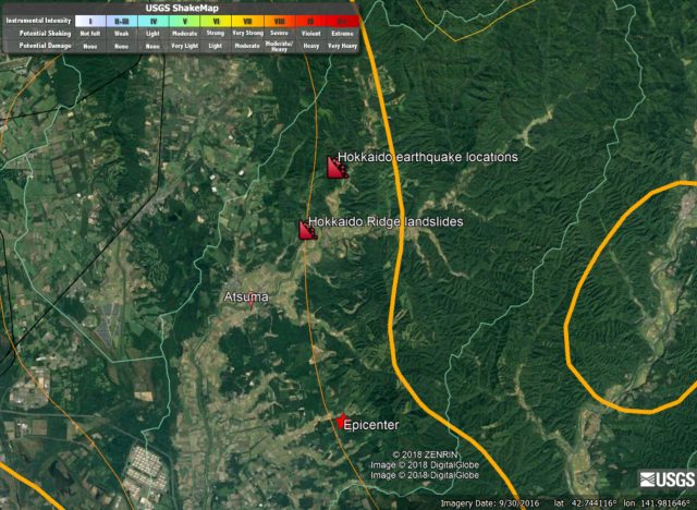
USGS Shakemap data for the 6th September 2018 Hokkaido earthquake.
.
The two areas of landslides shown above are dramatic. The ridge landslides are shown in the image below – here we seem to see failure from the ridge crest (which is typical for earthquakes) along the vast majority of the topographic feature. Sadly, at the toe of the slope were located a number of houses. The level of destruction seems to be very high; at 3 am the likelihood of escape for the occupants would have been low. Fortunately the integrity of at least some of the houses may have protected the occupants:-
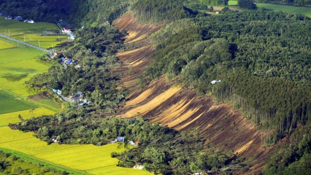
The ridge failure landslides from the 6th September 2018 Hokkaido earthquake. Image via SCMP.
.
In some cases the runout distance seems to be high. Note that the exposed slopes look to be both deeply weathered and wet, although there is not much evidence of water flowing.
The second area shown in the maps above is the zone of extremely dense landslides shown in the image below:-
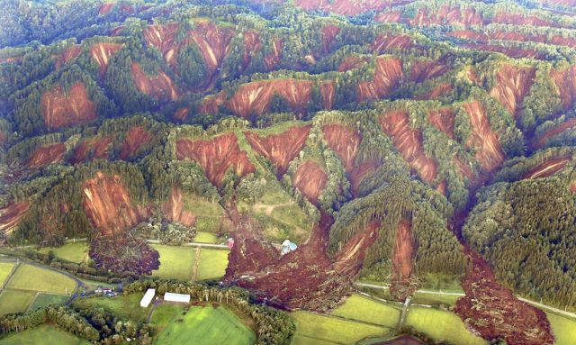
The area of intense landslides from the 6th September 2018 Hokkaido earthquake. Image via Tokyo Keizai.
.
Again note that most of the landslides, which are again in deeply weathered materials, originate from the ridge crest. The runout distances look quite long again, and in some cases they have coalesced in the drainage lines (channels) to form larger flows.
Given the earthquake magnitude (Mw=6.6 or 6.7), and depth (USGS reports 33.4 km), this level of landsliding is unusual. Indeed the USGS PAGER tool continues to indicate a low level of landslide activity. It is is likely that this high level of landslides is the result of the effects of Typhoon Jebi (Typhoon 21 in Japan), which passed over Japan in the few days before the earthquake. This might have saturated the slopes. Alternative factors may include some aspect of the shaking – perhaps the frequency was exactly right to create dramatic topographic amplification in this topography. Or perhaps the materials – these slopes may well be formed from young volcanic deposits I suspect – were particularly susceptible to seismic shaking. I wonder if there might be an element of liquefaction in some of these failures?
I am sure a great deal more detail will emerge in the days ahead. Comments and observations are very welcome.
5 September 2018
The Mw=6.6 earthquake in Hokkaido, Japan: early indications of significant landslides
The Mw=6.6 Hokkaido earthquake in Japan: early indications of significant landslides
The Mw=6.6 earthquake in Hokkaido, Japan at 3:08 am local time today appears to have generated significant numbers of landslides. On Twitter, Jamie Gurney has captured two images from a live broadcast on the Japanese broadcaster NHK that indicate that in at least a part of the earthquake-affected area, many large landslides have been triggered:-
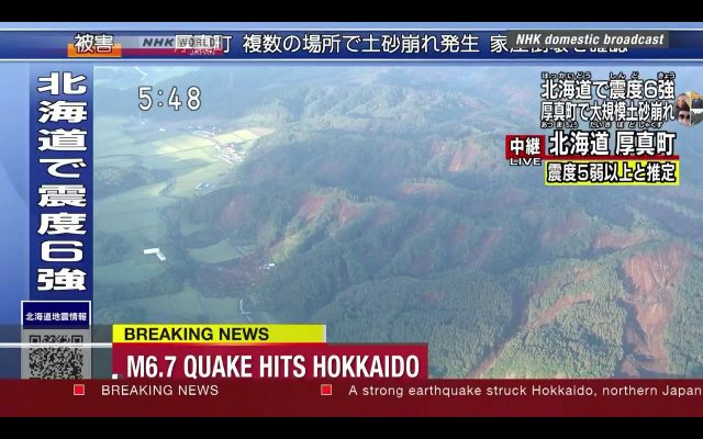
Landslides from the Mw=6.6 earthquake in Hokkaido, Japan. Image from a live broadcast by NHK, via Jamie Gurney.
.
These are classic co-seismic landslides, apparently being triggered at the ridge crest and then involving the entire length of the slope. Note the two landslides on the left of the image that appear to have run out a significant distance onto the flatlands. One of these appears to involve a substantially damaged building.
The image below, also from NHK via Jamie Gurney, shows another area of earthquake-induced landslides:-
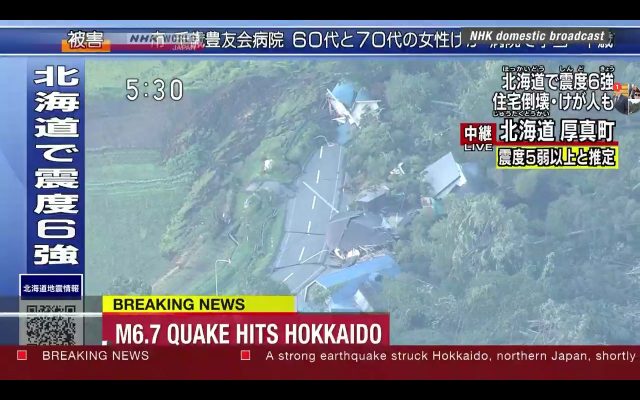
Detail on one of the landslides from the Mw=6.6 earthquake in Hokkaido, Japan. Image from a live broadcast by NHK, via Jamie Gurney.
.
In this case there appears to be substantial damage to properties and a road. It seems likely that there will be casualties.
Interestingly, as Sotiris Valkaniotis has also pointed out on Twitter, the USGS Pager landslide model appears to be doing a poor job of predicting this level of landsliding. The current first pass estimate of area susceptible to landsliding is very low:-
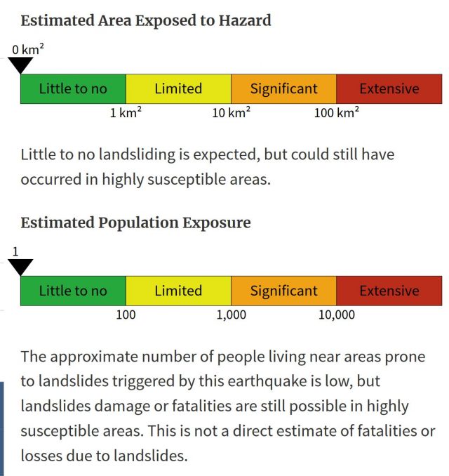
USGS Pager estimate of landslide hazard and population exposure for the Mw=6.6 earthquake in Hokkaido, Japan. Image from USGS.
.
That is not a criticism in any way of the model – this stuff is really, really hard. There are two obvious possible explanations. The first is that the PAGER model is not describing the ground shaking well at this stage, which was the point that we made in our recent paper about the Kaikoura earthquake in New Zealand (Massey et al. 2018). The other is that the ground was saturated in the aftermath of Typhoon Jebi, and earlier rainfall events that have affected Japan this summer, leaving the ground much more susceptible to landslides. Such effects are really hard to capture.
The picture from Hokkaido will become clearer over the next few hours. Please post comments (or send me a Tweet – @davepetley) if you have any information or images.
Reference
C. Massey, D. Townsend, E. Rathje, K. E. Allstadt, B. Lukovic, Y. Kaneko, B. Bradley, J. Wartman, R. W. Jibson, D. N. Petley, N. Horspool, I. Hamling, J. Carey, S. Cox, J. Davidson, S. Dellow, J. W. Godt, C. Holden, K. Jones, A. Kaiser, M. Little, B. Lyndsell, S. McColl, R. Morgenstern, F. K. Rengers, D. Rhoades, B. Rosser, D. Strong, C. Singeisen, M. Villeneuve. 2018. Landslides Triggered by the 14 November 2016 Mw 7.8 Kaikoura Earthquake, New Zealand. Bulletin of the Seismological Society of America doi: https://doi.org/10.1785/0120170305
4 September 2018
Boulder roll – a surprising video (updated with location)
Boulder roll – a surprising video (now updated with the location)
I have posted previously about the hazards associated with rolling and jumping boulders, and the damage that they can cause. Generally speaking we think of the greatest hazard being posed by boulders traveling down long, steep slopes, and thus having very high kinetic energy. However, this is not necessarily the case. A video has emerged, and been posted to Youtube, from Uttarakhand in the last few days that shows that even boulders without long fall heights can be extremely dangerous:-
.
This is a very nice example of a boulder roll. There is really not much information on Youtube about where this happened, other than being within Uttarakhand in northern India. But the video includes a location sign, and in a pair of comments below reader Anne Roseveare indicates that these names translate to: Sama, Liti, Tejam and Namik. She indicates that this means that the area can be found in this link to Googlemaps.
The video suggests that this is a deeply weathered slope, which possibly has been cut for the road. The large boulder is released by the slope, and manages to achieve significant speed despite the low fall height. Clearly this would be exceptionally dangerous for road users:-
A still from a Youtube video showing a boulder roll event in Uttarakhand in northern India. The video was posted on 28th August 2018.
.
I think that this video should be required viewing for those who are willing to cut slopes without thinking of the potential consequences.
 Dave Petley is the Vice-Chancellor of the University of Hull in the United Kingdom. His blog provides commentary and analysis of landslide events occurring worldwide, including the landslides themselves, latest research, and conferences and meetings.
Recent Comments