
4 December 2020
Haines, Alaska: a major landslide leaves people missing
Haines, Alaska: a major landslide leaves people missing
Heavy rainfall this week triggered landslides around the town of Haines in Alaska, causing extensive damage. Around 200 mm fell on Tuesday and Wednesday, with the additional effect of melting snow pack. Heavy rain on snow is a scenario that has previously proven to be effective in generating failures.
The largest failure appears to have occurred at the Beach Road residential area close to the town of Haines. The image below of the landslide has been published by Alaska Public Media. It seems that four houses were destroyed:
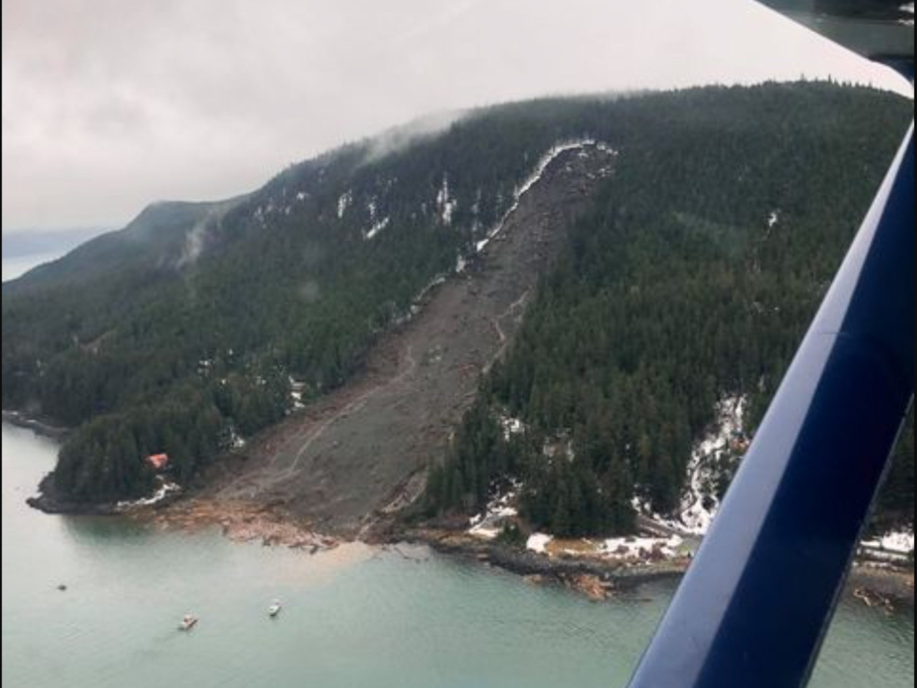
The landslide in Haines, Alaska on Wednesday, Dec. 2. (Image by Jacob Cheeseman, published by Alaska Public Media).
.
This is clearly a major rockslide. Note the shattered timber at the foot of the landslide. Whilst initial reports indicated that six people might be missing in this landslide, most of those have now been accounted for. However, two people, the residents of one of the houses destroyed, remain missing. If they were in the property at the time of the landslide then the prospects are bleak.
This view was also published by Alaska Public Media:
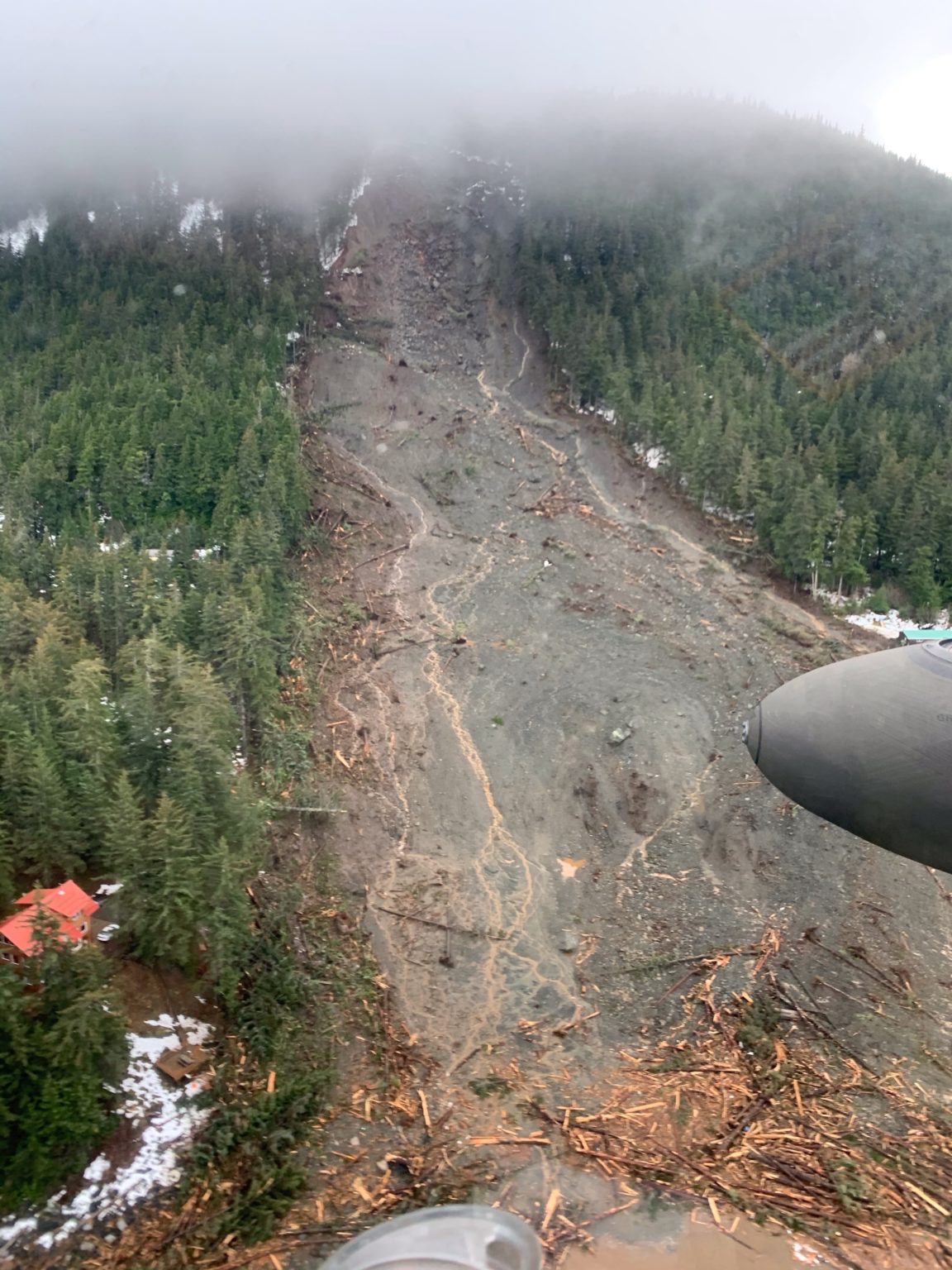
The landslide in Haines, Alaska on Wednesday, Dec. 2. (Image by st Lt. David Marshall/Alaska Army National Guard, published by Alaska Public Media).
.
This looks to be a relatively deep-seated rock slope failure high up on the slope, with entrainment of material along the length of the slope to the water. The timber is extremely shattered, suggesting an energetic failure. Most of the debris appears to be under the water. Some images show pieces of destroyed timber houses floating in the water.
Other landslides have been reported, most notably at the Macaulay Salmon Hatchery in Juneau, where a water pipeline supplying the hatchery was destroyed by a slip. As the site was without a source of freshwater, the staff at the hatchery have been forced into destroying their stock of young chinook salmon and rainbow trout, which would have been released in the spring, as well as many of the young coho salmon.
.
Acknowledgement
Many thanks to a number of people who contacted me directly or via Twitter about this slide. I have drawn heavily on the links that you sent.
3 December 2020
High resolution satellite images of the Guinobatan lahar
High resolution satellite images of the Guinobatan lahar
A month ago, Typhoon Goni (known locally as Rolly) brought heavy rainfall to the Philippines, causing extensive damage. One of the most serious events triggered by the typhoon was the Guinobatan lahar, which flowed down the flanks of Mount Mayon, an active stratovolcano.
Plant Labs have very kindly collected and processed high resolution satellite imagery of the aftermath of the lahar. Once again I thank them for their support and for making this amazing imagery available – it is transformative in our understanding of these events.
This is an image of the area affected by the lahar, collected on 23 October 2018:
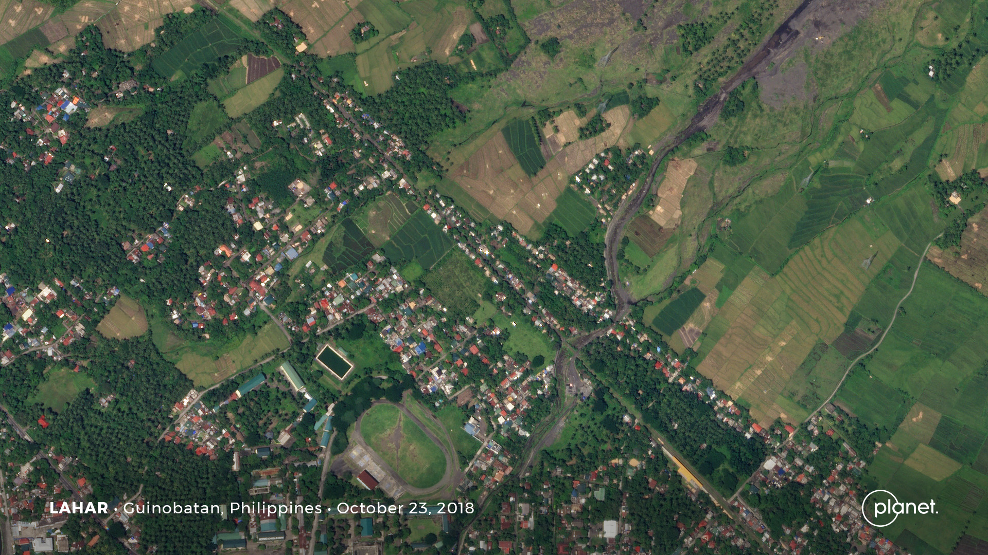
The area affected by the Guinobatan lahar before the event. Planet Labs SkySat image, copyright Planet Labs, used with permission.
.
And in contrast, this is an image of the aftermath of the lahar, collected on 14 November 2020:-
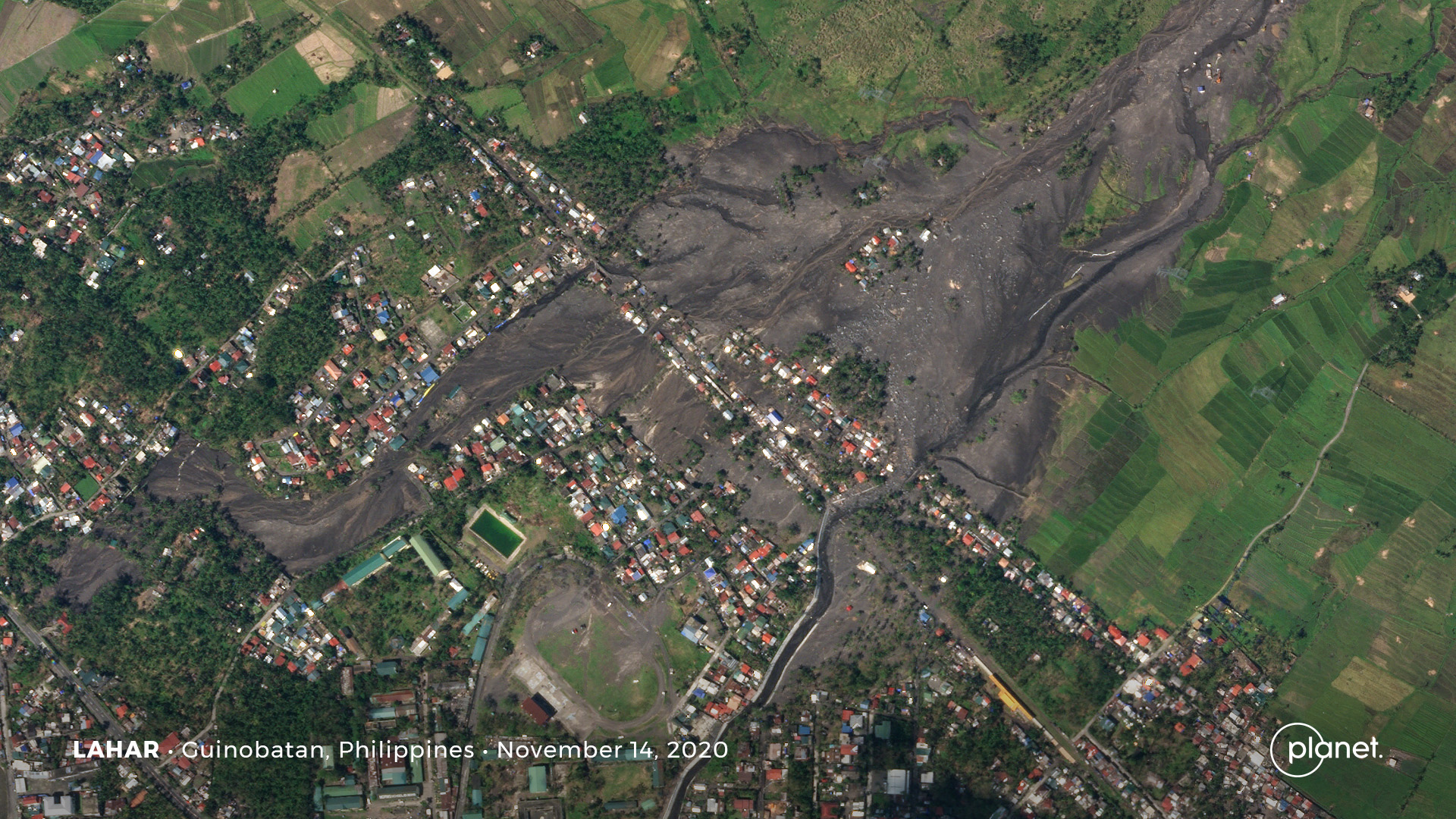
The aftermath of the Guinobatan lahar. Planet Labs SkySat image, copyright Planet Labs, used with permission.
.
I have used Juxtapose to create a slider that allows comparison of the images.
In the image before the lahar the existing channel cuts through the settlement. There is a hint that lahars have affected a much wider area, especially in the upper central part of the image where there considerable areas of sparse vegetation.
In the second image it is clear that the Guinobatan lahar overflowed the channel upstream of the houses, spreading over a large area. Indeed the main flow appears to have followed a different path altogether, penetrating a long distance into the settlement. There are a large number of houses affected.
Interestingly, the lahar has reoccupied some abandoned channels, especially on the eastern side. There are other abandoned channels that this event has not reoccupied.
These images serve to highlight the hazards posed by lahars, the vulnerability of settlements to them and the repeat nature of these events.
.
Reference and acknowledgement
Planet Team (2020). Planet Application Program Interface: In Space for Life on Earth. San Francisco, CA. https://www.planet.com/
2 December 2020
Gamsberg mine in South Africa: when is a landslide a geotechnical failure?
Gamsberg mine in South Africa: when is a landslide a geotechnical failure?
Gamsberg mine is a comparatively new open cast pit in the Northern Cape, South Africa. Operated by Vedanta Zinc International, it currently produces 400,000 tonnes of ore per month. Once full production capacity is reached Gamsberg is expected to produce 4 000,000 tonnes of ore and 250,000 tonnes of zinc-in-concentrate per year. The current reserve and resource is 214 million tonnes, and operations are estimated to last about 30 years.
On 17 November at about 1:15 am Gamsberg suffered what its owners are describing as a “geotechnical failure” that was sufficiently large to require that the company release a formal statement. The failure occurred in a high wall excavation known at a part of the mine known as the South Pit. At the time of the failure there were ten members of staff at the bottom of the pit. Eight were rescued, but it appears that the other two were killed.
The failure is sufficiently large that it is clearly visible on the daily Planet Labs imagery. The images below show the South Pit; the left image was captured on 14 November, before the landslide, and the image on the right was captured after the event on 17 November.
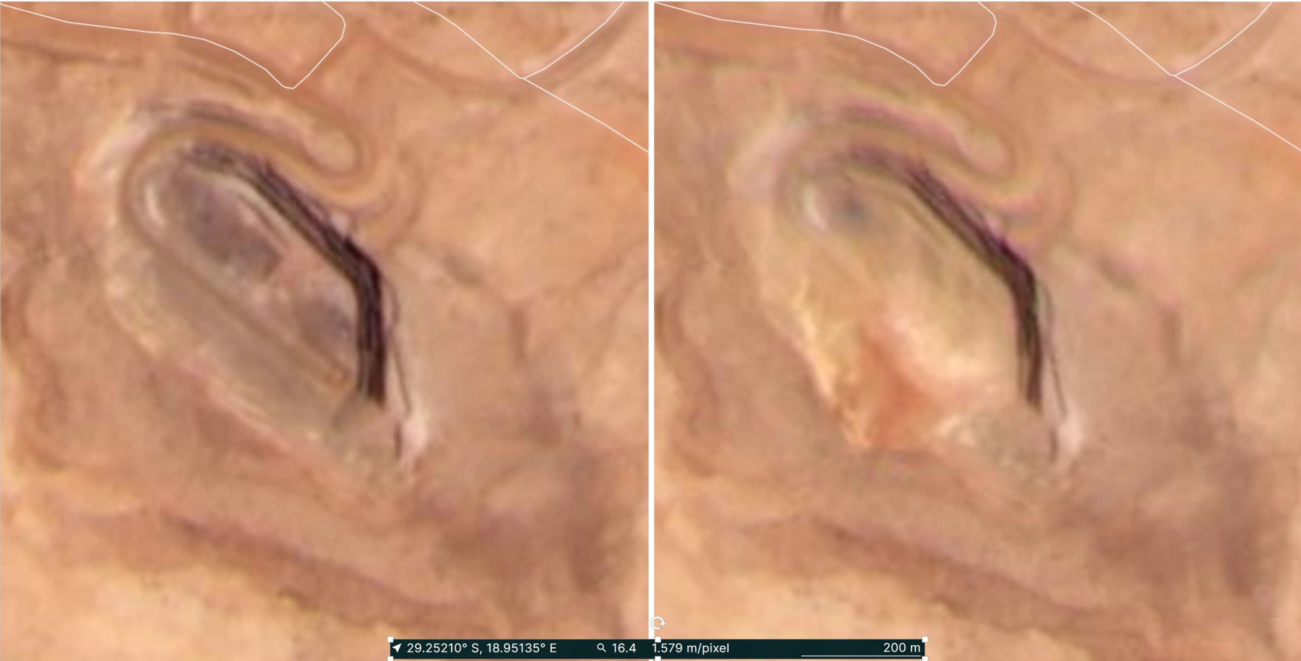
Planet Labs imagery showing the Gamsberg mine before the failure (left, collected on 14 November 2020) and after (right, collected on 17 November 2020). Images courtesy of Planet Labs,used with permission. Copyright Planet Labs.
.
Images of the landslide at Gamsberg mine have also been posted to Reddit. This image provides an overview of the landslide itself:-
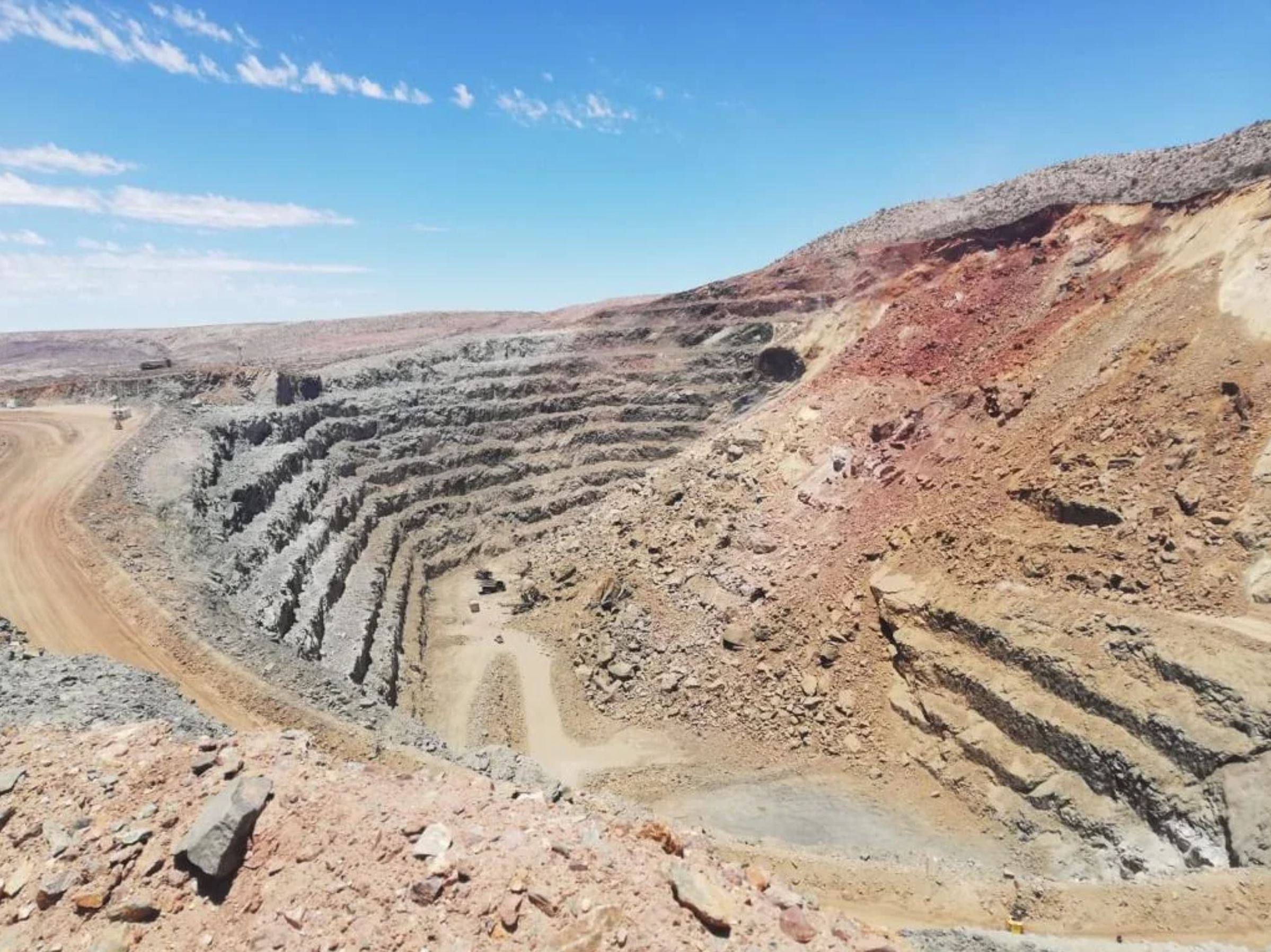
An overview of the landslide at Gamsberg mine. Image posted anomalously to Reddit.
.
Whilst this image shows the damage caused by the landslide:-
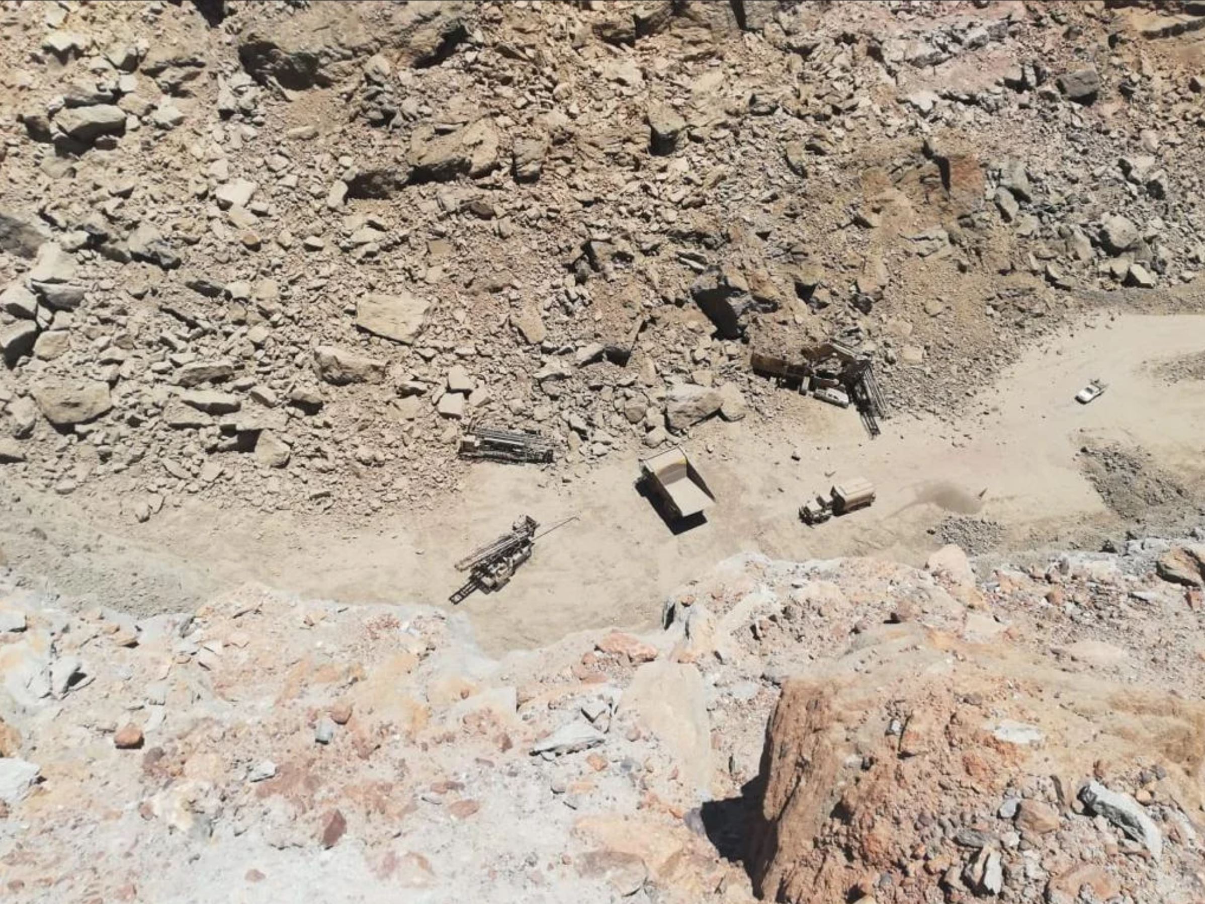
The damage caused by the landslide at Gamsberg mine. Image posted anomalously to Reddit.
.
There is very little additional information about this very large mining landslide. The impact on the workers in the mine and to the equipment above suggests that it might not have been anticipated. As high wall mines often have sophisticated monitoring of their slopes, it is increasingly unusual for the operators to be taken by surprise by such events.
.
Reference and acknowledgement
Planet Team (2020). Planet Application Program Interface: In Space for Life on Earth. San Francisco, CA. https://www.planet.com/
30 November 2020
Developing problems at Rest and Be Thankful
Developing problems at Rest and Be Thankful
In recent months I have posted on a number of occasions about the developing landslide problems at the now infamous Rest and Be Thankful in W Scotland. Unfortunately, the landslides there continue to develop, causing increasing levels of disruption. Last night both the A83 itself and the Old Military Road diversion were closed once again as a precaution. We are in a spell of repeated rainfall events in the area; with the material being so unstable on the slope the roads cannot be safely operated in the dark (and of course the nights are very long in Scotland at this time of the year).
BEAR NW Trunk Roads have been proactive in providing information as to why these road closures are needed. They are aware that these problems are causing substantial disruption. On 25 November they tweeted a drone video of the site above the road that is now causing so much concern:
#A83 #RestAndBeThankful: OMR to remain *CLOSED* overnight & throughout Thursday as a safety precaution with material continuing to move down the hillside. The drone footage below shows the damaged slope above the A83 that resulted from the landslips of earlier this year. (1/2) pic.twitter.com/xjRcKM507n
— BEAR NW Trunk Roads (@NWTrunkRoads) November 25, 2020
.
This video shows the range of landslide types now active at Rest and Be Thankful. Of particular interest is the landslide in the centre of the video, which is clearly retrogressing and releasing a large volume of debris:-
The state of the landslide at Rest and Be Thankful in Scotland. Still from a drone video tweeted by BEAR NW Trunk Roads.
.
Note the shallow flow to the left as well, the source of which lies much further up the hillside.
The main landslide highlighted above involves a large volume of material, and it is actively destabilising more. BEAR NW Trunk Roads has also tweeted these time lapse videos showing movement of material in the main landslide during heavy rainfall:-
#A83 #RestAndBeThankful: Here's a clip of our timelapse camera showing the recent debris movement on a loop -teams are monitoring the hillside continuously. All traffic continues to be diverted via A82, A85 & A819 as a safety precaution. Read more: https://t.co/Vln8hfk6JT (2/2) pic.twitter.com/Sapj6OkIno
— BEAR NW Trunk Roads (@NWTrunkRoads) November 24, 2020
.
The second of these videos shows the full magnitude of the challenges faced by the geotechnical engineers and engineering geologists at this site, and the amount of material that could become involved. Given the terrain, this is not a problem that is going to be fixed anytime soon, although works are underway to try to minimise the impacts.
19 November 2020
Guinobatan: a major lahar in the Philippines triggered by Super Typhoon Goni
Guinobatan: a major lahar in the Philippines triggered by Super Typhoon Goni
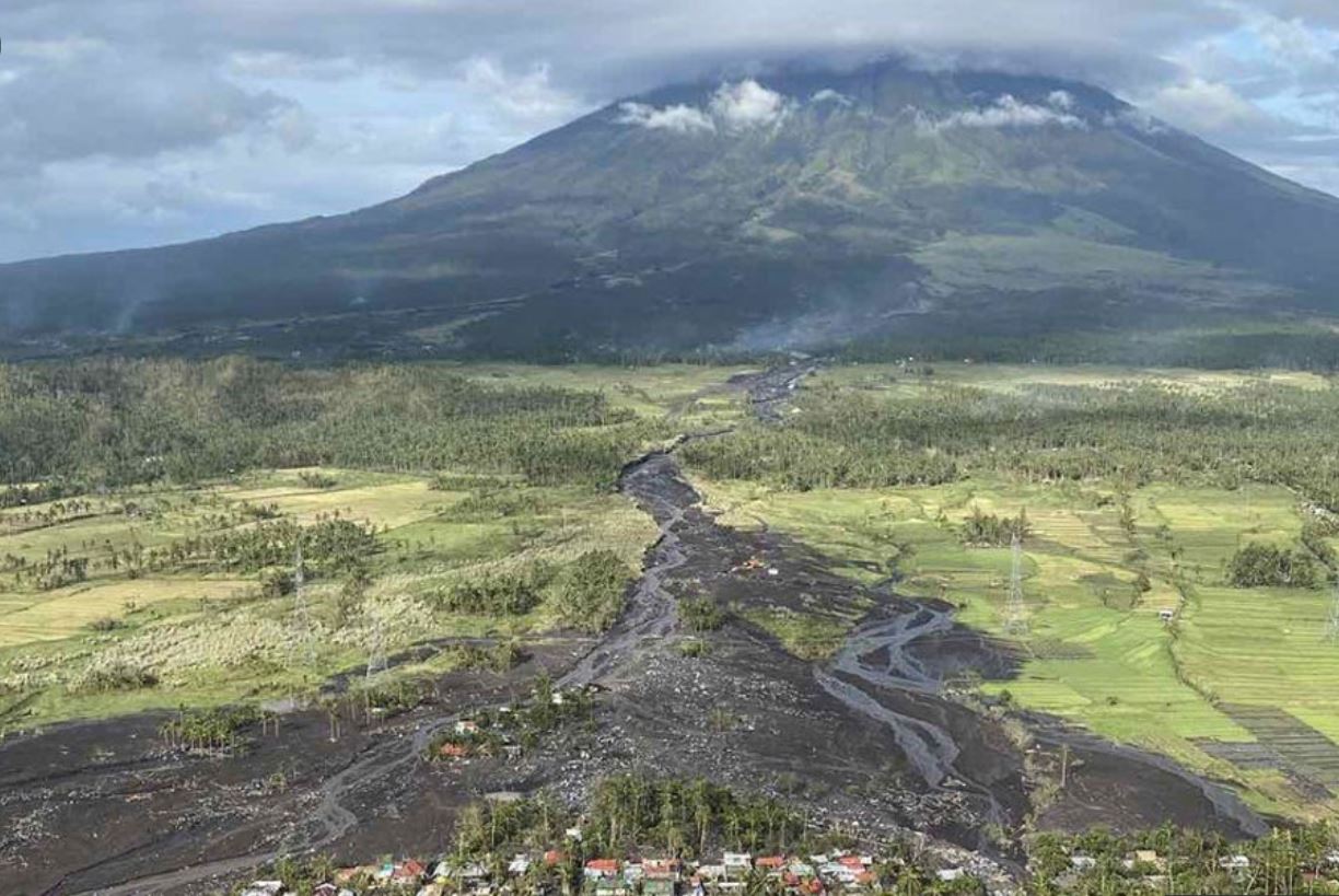
Super typhoon Goni (known locally as Rolly) brought extensive heavy rainfall to the Philippines over the weekend of 31 October and 1 November 2020. Widespread damage occurred, including landslides in many places. Very significant damage occurred in the town of Guinobatan in Albay, caused by a lahar from the flanks of Mount Mayon, an active stratovolcano.
The best image that I can find of the lahar itself appears in a video interview of the governor of Albay province by ABS-CBN News:-
The aftermath of the lahar at Guinobatan in the Philippines. Image via ABS-CBN News.
.
Reports indicate that the lahar struck around about 150 houses in and around Guinobatan, with seven fatalities. There is now considerable controversy as to whether quarrying on the slopes of Mount Mayon may have been responsible for the lahar.
Planet Labs have captured a good image of the aftermath of the lahar at Guinobatan:
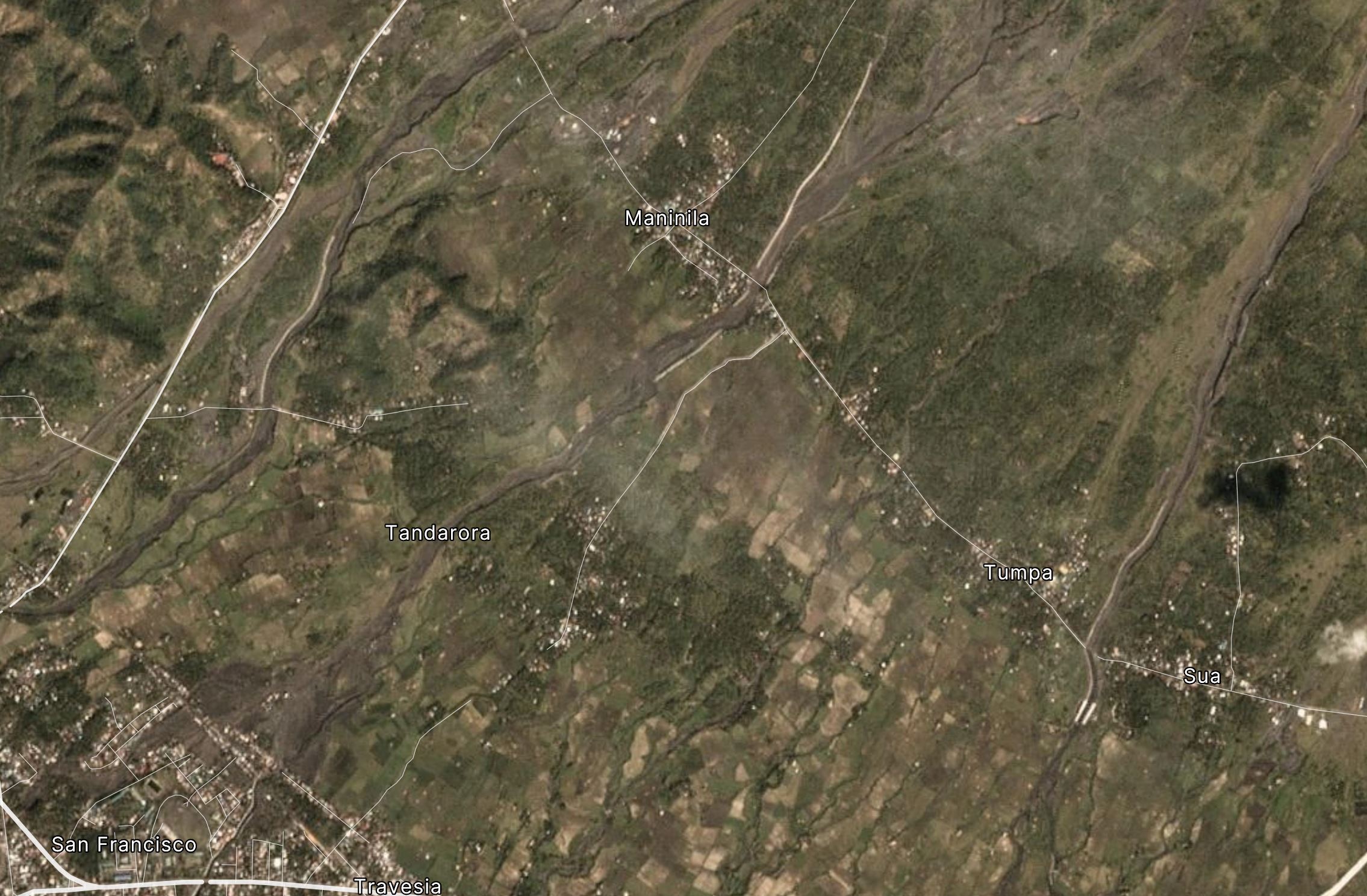
Planet Labs image of the aftermath of the lahar at Guinobatan. Planet Labs PlanetScope image captured on 13 November 2020. Copyright Planet Labs, used with permission.
.
The image shows that the lahar passed to the east of the village of Maninila and then through the isolated houses at Tamdarora before striking the northeast margin of Guinobatan (in the southwest of the image above). it is clear that many properties were destroyed in the lahar.
The imagery does not provide strong evidence to support or refute the premise that quarrying may have been an issue. However, Mount Mayon has a long history of deadly lahars. Wikipedia has a good description of these events, which includes a major event on 30 November 2006, in which at least 1.266 people were killed. Whilst most of the damage occurred in Padang, on the outskitrts of Legazpi City, large areas of Guinobatan were also destroyed. Another major lahar occurred in October 1766, again triggered by a typhoon, and again in 1825, when 1,500 people died.
.
Reference and acknowledgement
Planet Team (2020). Planet Application Program Interface: In Space for Life on Earth. San Francisco, CA. https://www.planet.com/
18 November 2020
Argaga: the major rockfall on La Gomera on 14 November 2020
Argaga: the major rockfall on La Gomera on 14 November 2020
Videos were widely shared on Twitter over the weekend showing remarkable footage of a major rock slope collapse at Argaga on the Spanish island of La Gomera on 14 November 2020. This is a large, near vertical collapse event, with the debris falling onto a road and into the sea. Fortunately no-one was killed.
There are actually two videos of this event, both capturing slightly different elements. Together they provide a very useful documentation of the failure. The first starts about a minute before the collapse. When the video starts there is some dust close to the rock slope. Over time, isolated (though not trivial) falls occur across the slope:-
.
The person collecting this video is clearly concerned about the potential for a displacement wave (sensibly), and so evacuates when the collapse occurs.
The second catches less of the precursory activity, although the main collapse is well constrained:
.
But this one captures the aftermath of the landslide, including the displacement wave that is generated by the collapse, as well as the very impressive cloud of dust.
In this case failure has been controlled by near vertical joints in the volcanic rocks. Collapse would have been controlled by the development of new fractures that linked the existing joints together to create the release surface. As this proceeded the rock mass crept and deformed at an accelerating rate. It is this deformation that pops off the precursory rockfalls. These precursors are of course invaluable as they often warn people in the vicinity that failure is developing, and in this case it also meant that people started to video the slope.
El Pais reports that rockfalls are common on this stretch of cliff. The owners of this vehicle might consider themselves somewhat fortunate:
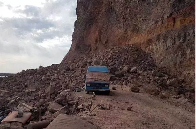
The aftermath of the rockfall at Argaga. Image by INVOLCAN via Europapress.
.
Quickslide 1: Hurricane Iota has made landfall in Central America
Hurricane Iota crossed the coast in Central America yesterday, bringing exceptional rainfall and very high winds. We await to see the level of damage that it has caused, but landslides are inevitable.
.
Quickslide 2: Investigations of the peat landslides in the Republic of Ireland
The Independent in Ireland has a good article on the aftermath of the two peat slides in the Republic of Ireland last week. I will be interested to see what the investigations find.
17 November 2020
Mount Eagle: another peat slide in Ireland
Mount Eagle: another peat slide in Ireland
Amongst the focus on the major peat slide in Meenbog in the Republic of Ireland over the last few days, it slipped my attention that another event occurred, this time at Mount Eagle in County Kerry. The Farmers Journal has an article that provides the detail. The landslide has occurred on a Sitka spruce plantation in a peat bog area of County Kerry on land owned by Coillte, the state owned forestry company.
The best imagery that I have seen has been posted to Twitter by Save Kerry (@SaveKerry):
https://twitter.com/SaveKerry/status/1328059773825257475?s=20
.
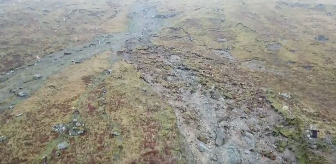
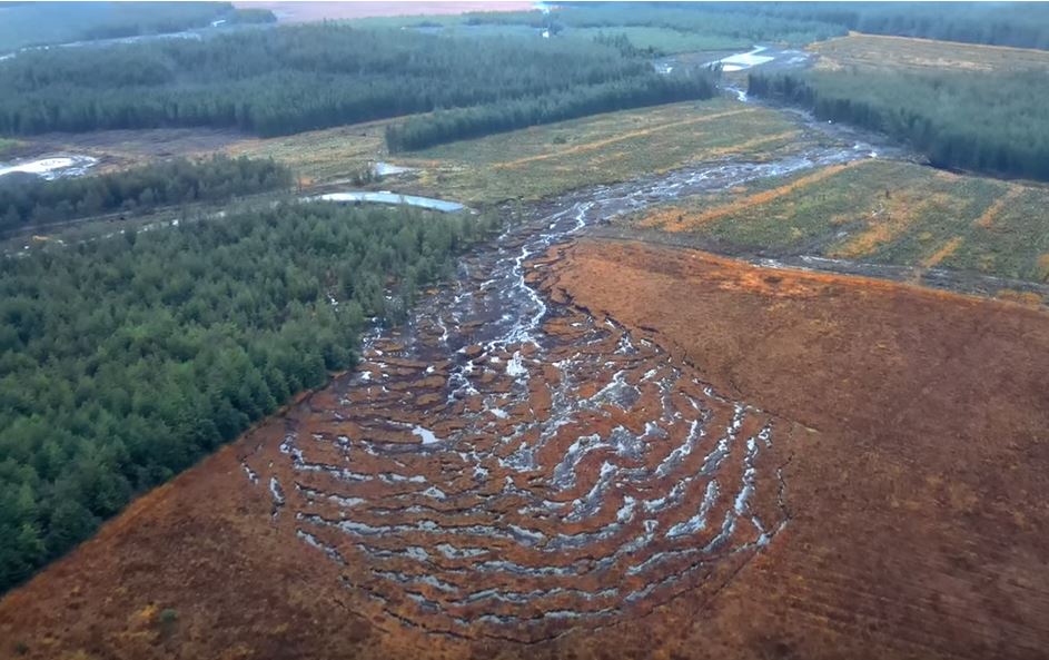
On this occasion the peat slide appears to have started in the middle of the Sitka spruce plantation. It has displaced a large amount of bog, and as observed previously movement is shallow, consisting of rafts some of which include upright trees. The image below is a screenshot showing these rafts:
The Mount Eagle peat slide. Still from a drone video posted to twitter by Save Kerry.
.
As the above image shows, the deformed land is highly chaotic, without the ordered structure seen in the Meenbog slide. I suspect that this may indicate that the this is not an area that has been affected by retrogression of the landslide. I would like to see an image that captures the whole of the source area of the Mount Eagle peat slide.
Downslope, the Mount Eagle peat slide has transitioned into a channelised flow with a long runout, in common with the many other failures of this type that I have described on this site. There are concerns for drinking water quality and for the ecological impacts downstream.
The trigger for these landslides is undoubtedly the recent heavy rainfall. The spate of events that we have seen this year so far reflects the periods of extremely wet weather that have occurred over the British Isles in 2020. But the precise mechanism of the initiation of the failures is not clear. I think that there is a particular question to be asked about the role that the spruce plantations play in initiating the slides (this may be related to the way that the trees create rafts of material and/or the ways that they change the drainage of the bogs), as well as the impact of wind farm construction in triggering instability.
As I have noted previously, global heating will mean that these prolonged spells of rainfall, and shorter duration high intensity rainfall events, will increase, so we might expect to see more failures of this type. Blanket bogs are an important habitat in the UK and in Ireland, and of course they are a major carbon store. Restoration is a very slow and difficult process. So, in my view, there is an urgent need to undertake research to understand these landslides better, and to ensure that the land is managed properly. A combination of detailed field monitoring and novel lab testing should yield some fascinating results.
16 November 2020
The Meenbog peat slide in the Republic of Ireland
The Meenbog peat slide in the Republic of Ireland
There was a great deal of interest over the weekend in a peat slide that was caught on video at Meenbog in the Republic of Ireland. The landslide occurred on 13 November 2020. This is the video on Youtube:
.
The video is remarkable, showing rafts of bog with intact and upright trees sliding along a low angle slope. The peat blog landslide is large – as is so often the case with landslides in peat, the landslide has runout a very long distance, all the way to the major watercourse. There is an excellent drone video of the landslide track, also on Youtube:
.
The image below, a still from the video above, captures the upper part of the landslide:-
The upper part of the Meenbog peat landslide in the Republic of Ireland. Image captured from a video posted to Youtube.
.
The upper portion of the Meenbog peat landslide is an extensional zone, almost certainly caused by retrogression (uphill expansion) of the slide after the initial failure. It is possible that failure started towards the downslope end of this bowl. It is unlikely to be a coincidence that a ditch crosses the slope at this point. Downslope from the landslide becomes a channelised flow.
The landslide has occurred in an area in which construction is underway for the Meenbog wind farm, a project that has been controversial. According to the Irish News, “The wind farm is owned by global retail giant Amazon, which aims to have the site operational by 2022“.
I have written about peat landslides previously, most notably in relation to the broadly similar Dawn of Hope peat landslide earlier this year. Peat is a very strange geotechnical material, with very low density, low compressive strength but some strength in tension due to the fibrous nature of the material (which is how it can generate the rafts seen on low angled slopes). It generally has an exceptionally high water content. Once disturbed it has a very low shear strength, allowing long runout landslides to develop. Especial care is needed to avoid instability in areas of blanket peat coverage.
The trees involved are Sitka spruce. According to the USDA Forest Service, these trees have roots systems that are “shallow and platelike with long lateral roots with few branchings. On deep well-drained soils the root system may reach depths of 6.5 feet (2 m), especially on alluvial soils. Root grafting often occurs between roots of the same tree and adjacent trees”. This explains how trees can be involved in the rafts of the peat slide.
The threat of peat slides from wind farms is well-established – indeed in 2003 a major peat slide was triggered by the construction of a wind farm in Derrybrien. As the Galway Daily notes:
“The Irish State was found to be in breach of environmental safeguards during the construction phase of the project. On top of the €5 million lump sum which the Department of Housing, Planning and Local Government has confirmed as paid over, Ireland still faces daily fines of €15,000 until the situation is rectified.”
I find it hard to understand how this can happen again.
.
Quickslide 1: Hurricane Iota is heading for Central America
Quickslide 2: The anticipated landslide in West Dorset occurred on 15 November
On Friday in the Quickslide section I highlighted that a slope failure was developing near to West Bay in Dorset. This slope failed in the early morning of 15 November 2020.
13 November 2020
Quang Nam Province: A video that shows why the aftermath of a landslide can be very dangerous
Quang Nam Province: A video that shows why the aftermath of a landslide can be very dangerous
Further heavy rainfall is triggering landslides in Vietnam. Unfortunately Typhoon Vamco is likely to make landfall over the weekend, bringing further rainfall into areas that are already saturated. Substantial problems are likely.
In the meantime, the ongoing landslides, triggered in initially by the succession of recent typhoons, are having a major impact. This is clearly illustrated by a frightening video of a small but nonetheless deadly landslide from Quang Nam Province, which has been posted to Youtube:-
.
The video shows a group crossing the site of a recent landslide. Fortunately someone shouts a warning and the group seeks to escape the landslide, as this still shows:
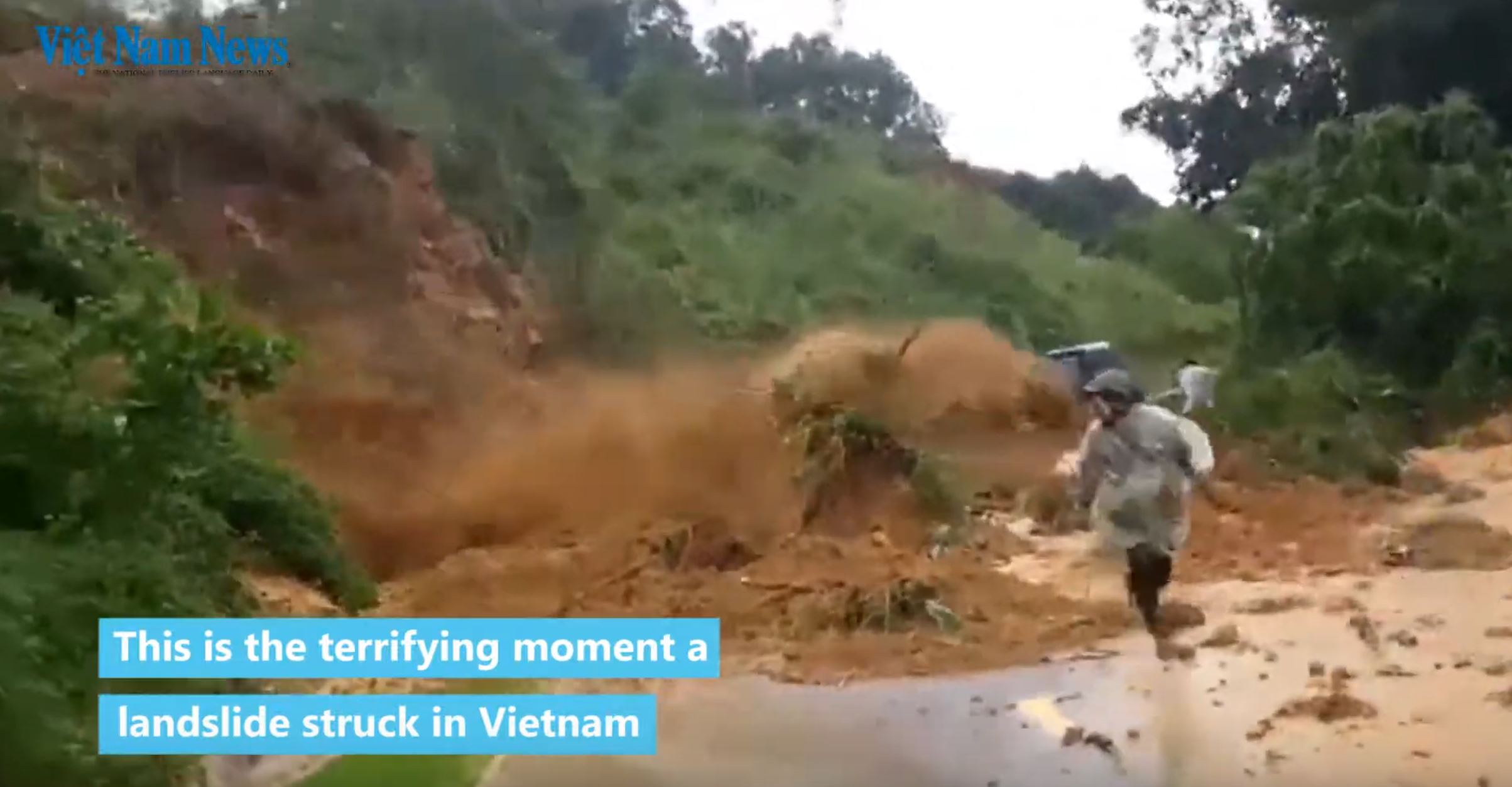
Quang Nam Province landslide: a still from a video posted to Youtube by Vietnam News
.
Apparently two people were caught in the landslide in Quang Nam Province – I suspect that this will have been the individuals on the far side of the failure when it initiated. There is some variation in the reports of the consequences, but it seems likely that one person was killed and another suffered a broken leg.
The video illustrates two key points. The first is that failures often repeatedly occur at the same site, so moving into the danger zone is exceptionally perilous. This is a particular issue for those undertaking rescues. The second is that even small failures can be exceptionally violent, especially when static liquefaction is invoked.
.
Quickslide 1: Gutemala requests international assistance
As Guatemala tries to recover from the recent floods and landslides, it is formally requesting assistance from the international community. Given the current chaos at the top of many international governments, I wonder whether it will receive the help it needs.
.
Quickslide 2: a large incipient landslide in Dorset
ITV reports that a large crack has opened up on the coastal path near to West Bay in Dorset. This is undoubtedly the development of a new failure on a section of coast in which landslides dominate the geomorphology.
11 November 2020
The Queja landslide: Planet Labs imagery
The Queja landslide: Planet Labs imagery
The search for the victims of the Queja landslide appears now to be ceasing, with the site of the disaster being declared a “camposanto”, or a resting place for the dead, and the location will be declared as being uninhabitable. Whilst understandable, one should not underestimate the impact on the remaining population, whose future will now be very perilous. AP has a nice syndicated article about the vulnerability of Guatemalan communities to future events. This will not be the last catastrophic landslide in Guatemala.
Meanwhile, the skies have finally cleared, meaning that optical satellite imagery has become available for the site. Planet Labs captured a good image of the location using their 3 m resolution PlanetScope instrument yesterday:-
The Queja landslide in Guatemala. Planet Labs PlanetScope image captured on 10 November 2020. Copyright Planet Labs, used with permission.
.
Note the scale bar , which gives an idea of the size of this landslide. On first inspection this image supports my sense that there are in effect two landslide sources here, both of which had an element of rotation before transitioning to a more flow style of movement. The larger to the two sources (source 1), to the north and west has generated a flow that has spread laterally, inundating a larger area. The other source (source 2) has spread rather less, but has had a longer runout. It is this part of the landslide that appears to have caused the greatest damage. As I noted in my first post on this failure, there is a stand of trees between the two sources.
I suspect some interesting work could be done on the timing of the two failures as there is some evidence of material from source 1 in the west side of the flow that is mostly from source 2.
.
Quickslide 1: a deadly landslide at a resort in Malaysia
Two people were killed in a hot springs resort landslide in Tambun, Malaysia. The failure was triggered by heavy rainfall.
.
Quickslide 2: The tenth anniversary of the Pike River Mine accident
Next Thursday (19th November) will be the tenth anniversary of the Pike River Mine disaster in New Zealand. Otago Daily Times has a good article about events on that tragic day. Attempts to re-enter the mine continue, but it is not possible to recover the victims.
.
Acknowledgement
Planet Team (2020). Planet Application Program Interface: In Space for Life on Earth. San Francisco, CA. https://www.planet.com/
 Dave Petley is the Vice-Chancellor of the University of Hull in the United Kingdom. His blog provides commentary and analysis of landslide events occurring worldwide, including the landslides themselves, latest research, and conferences and meetings.
Recent Comments