
30 November 2020
Developing problems at Rest and Be Thankful
Posted by Dave Petley
Developing problems at Rest and Be Thankful
In recent months I have posted on a number of occasions about the developing landslide problems at the now infamous Rest and Be Thankful in W Scotland. Unfortunately, the landslides there continue to develop, causing increasing levels of disruption. Last night both the A83 itself and the Old Military Road diversion were closed once again as a precaution. We are in a spell of repeated rainfall events in the area; with the material being so unstable on the slope the roads cannot be safely operated in the dark (and of course the nights are very long in Scotland at this time of the year).
BEAR NW Trunk Roads have been proactive in providing information as to why these road closures are needed. They are aware that these problems are causing substantial disruption. On 25 November they tweeted a drone video of the site above the road that is now causing so much concern:
#A83 #RestAndBeThankful: OMR to remain *CLOSED* overnight & throughout Thursday as a safety precaution with material continuing to move down the hillside. The drone footage below shows the damaged slope above the A83 that resulted from the landslips of earlier this year. (1/2) pic.twitter.com/xjRcKM507n
— BEAR NW Trunk Roads (@NWTrunkRoads) November 25, 2020
.
This video shows the range of landslide types now active at Rest and Be Thankful. Of particular interest is the landslide in the centre of the video, which is clearly retrogressing and releasing a large volume of debris:-
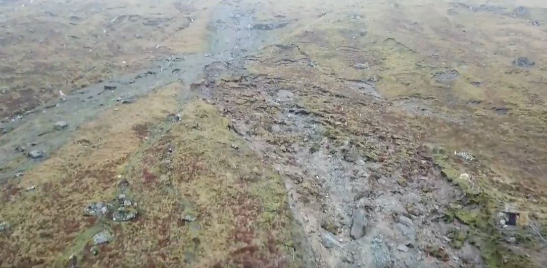
The state of the landslide at Rest and Be Thankful in Scotland. Still from a drone video tweeted by BEAR NW Trunk Roads.
.
Note the shallow flow to the left as well, the source of which lies much further up the hillside.
The main landslide highlighted above involves a large volume of material, and it is actively destabilising more. BEAR NW Trunk Roads has also tweeted these time lapse videos showing movement of material in the main landslide during heavy rainfall:-
#A83 #RestAndBeThankful: Here's a clip of our timelapse camera showing the recent debris movement on a loop -teams are monitoring the hillside continuously. All traffic continues to be diverted via A82, A85 & A819 as a safety precaution. Read more: https://t.co/Vln8hfk6JT (2/2) pic.twitter.com/Sapj6OkIno
— BEAR NW Trunk Roads (@NWTrunkRoads) November 24, 2020
.
The second of these videos shows the full magnitude of the challenges faced by the geotechnical engineers and engineering geologists at this site, and the amount of material that could become involved. Given the terrain, this is not a problem that is going to be fixed anytime soon, although works are underway to try to minimise the impacts.
 Dave Petley is the Vice-Chancellor of the University of Hull in the United Kingdom. His blog provides commentary and analysis of landslide events occurring worldwide, including the landslides themselves, latest research, and conferences and meetings.
I thought this was a post referring to American Thanksgiving, which I thought would be strange. Thanks for the blog.
One thing that always puzzles me about this type of landscape is whether it was once forested or not. Did humans or other phenomena cause the problem, or was this terrain always bare of vegetation?
[The native vegetation of Scotland is woodland. This was cleared several centuries ago for farming and hunting. However, these slopes have been comparatively stable since then (with some notable events), so it is not as simple as saying that the cause of these landslides is deforestation. Reforestation might be part of the solution, but getting trees to grow on unstable landslides is not straightforward. D]
I see that movement and immediately think: “So… What’s the other side of the valley like?”
There’s no way you can build an effective retaining wall for something like that – It would merely overrun and bury it. Maybe surface mesh and deep soil nails…..?
I’m going to check out geologic maps. That material looks like blocky melange we have here in coastal California. About all you can do is build rockfall nets and stay out of the way.
[The material is mostly lateral moraine and colluvium. It is a poorly sorted material with large angular blocks, so not dissimilar to the blocky melange indeed. D.]