18 May 2021
The Kara-Bogaz-Gol megaslide: the world’s largest active landslide?
Posted by Dave Petley
The Kara-Bogaz-Gol megaslide: the world’s largest active landslide?
A startling paper (Aslan et al. 2021) has just been published, open access (hurrah!), in the journal Scientific Reports, describing what is thought to be the largest active landslide so far identified on Earth. This is remarkable – the scale of the Kara-Bogaz-Gol megaslide is vast but until I read this paper I had no idea of its existence, even though it is clearly visible on Google Earth.
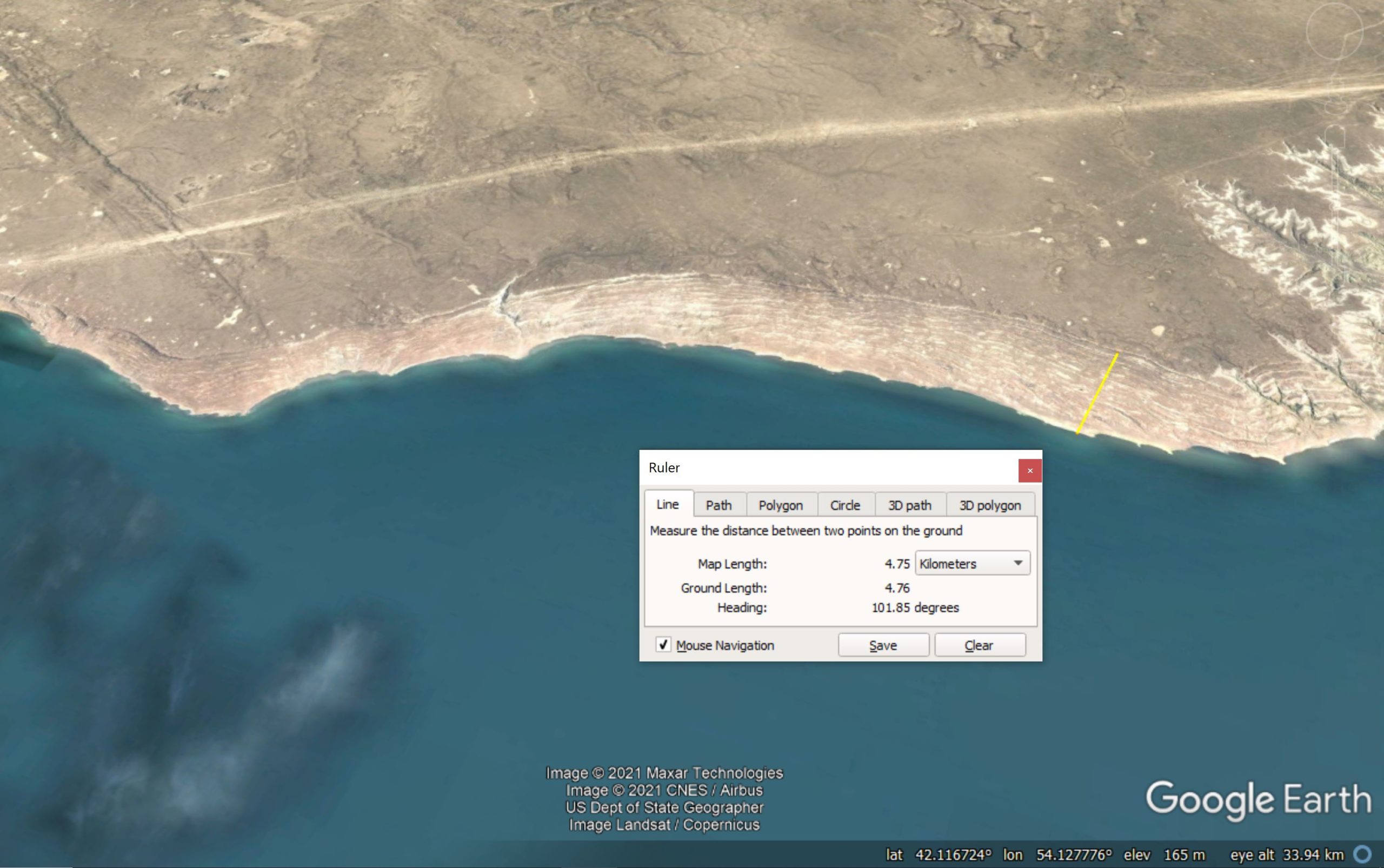
The landslide is located on the banks of the Kara-Bogaz-Gol lagoon in Turkmenistan. The landslide complex can be seen extending along the whole of the bay (and more) in the Google Earth image below, although not all of it is currently active. I have included a Google Earth ruler in the image so that you can appreciate the size of this failure:-

Google Earth image showing the whole of the Kara-Bogaz-Gol Megaslide.
.
The latitude and longitude of the landslide is given on the image above. The scale bar shows that the landslide is up to about 5 km from crown to toe, and the complex extends for over 40 km along the banks of the lagoon. This is a truly enormous landslide.
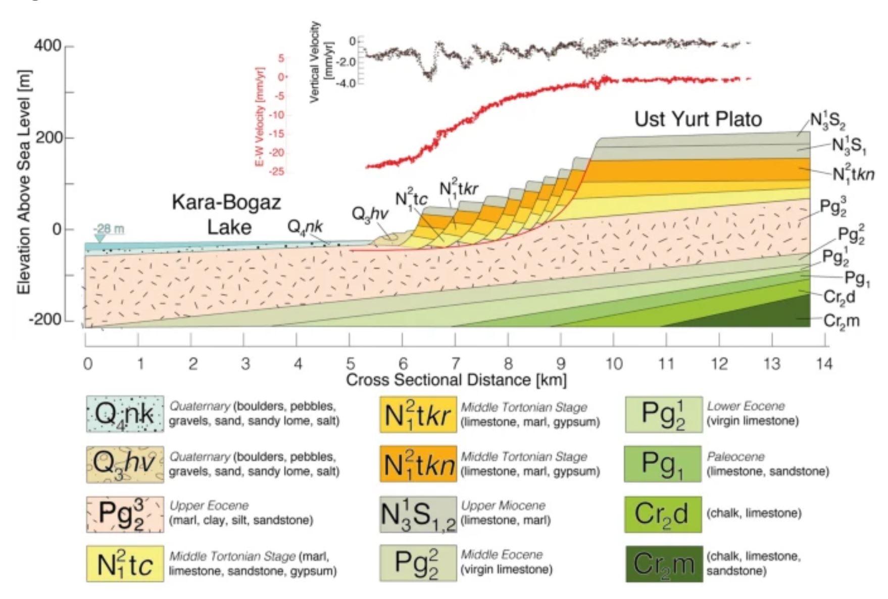
The Kara-Bogaz-Gol Megaslide is a rotational failure. Aslan et al. (2021) provide the following cross-section to illustrate its form:-

Schematic cross-section through the Kara-Bogaz-Gol megaslide. Diagram from Aslan et al. (2021).
.
As the cross-section shows, the landslide consists of thick blocks of limestones and marls failing of a gently dipping layer of weak Eocene marls, clays, silts and sandstones. At the top of the cross-section are two graphs showing the movement rate. In form this is broadly similar to the Ventnor landslide on the Isle of Wight, but on a much larger scale.
Aslan et al. (2021) have used 354 Sentinel IW SAR that span the period from 2014 to 2020 to extract movement data. They have shown that a mass that extends about 25 km along the lake shore and that extends up to 5 km inland is moving at up to 3 cm per year. This means that the volume of rock that is involved in the active part of the the Kara-Bogaz-Gol megaslide is about 10 cubic kil0metres! The movement rate is not constant, but responds to the level of the lake. Thus, when the lake level is high, and the soil moisture level is also high, more movement occurs.
The authors point out that this area is seismically active I would be fascinated to see how the Kara-Bogaz-Gol megaslide responds to a major earthquake.
.
Reference
Aslan, G., De Michele, M., Raucoules, D. et al. 2021. Transient motion of the largest landslide on earth, modulated by hydrological forces. Scientific Reports 11, 10407 (2021). https://doi.org/10.1038/s41598-021-89899-6


 Dave Petley is the Vice-Chancellor of the University of Hull in the United Kingdom. His blog provides commentary and analysis of landslide events occurring worldwide, including the landslides themselves, latest research, and conferences and meetings.
Isn’t the site in Turkmenistan rather than Kazakhstan?
[You are quite right, my apologies. Now corrected. D.]
Dave, the similarity to the Isle of Wight Undercliff ‘Upper Tier rotational failure mechanism and geometry’ is quite notable, albeit scale and geology differ somewhat. In the case of the Undercliff, what we observe above water is just the headscarp, the landslide extending offshore by some considerable distance. Makes me wonder how much of the Kara-Bogaz-Gol megaslide extends below water? Your readers may be interested in some 3D ground models I published in the following book chapter on the Undercliff for comparison: https://link.springer.com/chapter/10.1007/978-3-030-38957-4_8
[Many thanks Roger, that is a very interesting point. Bathymetry and seismic data would be really interesting. D.]
I note that the cross-section has a 10X vertical exaggeration. “Reservoir drawdown” feature? The Kara Sea was most likely full in the past (Holocene?). Approximate elevation change is around 900 feet in the area of the megaslide (according to GoogleEarth). No wonder the region is seismically active w/all that water/mass suddenly gone in a geological blink of an eye.
A point to ponder: these slide benches are remarkably parallel to one another (layers of an onion) and seem to mimic the shoreline. I wonder why?
Location at Lat 41.703n and Long 54.046e,
and oriented north to the left side of the screen
is better to visualizein Google Earth