
17 May 2021
The 17-18 December 2020 landslide disaster in Presidente Getúlio, southern Brazil
Posted by Dave Petley
The 17-18 December 2020 landslide disaster in Presidente Getúlio, southern Brazil
Authors: Renato Lima (UFPR – CENACID), Fabiane Acordes (Paraná State Civil Defense – CENACID), Wilson Soares (UFPR, CENACID) and Jefferson Picanço (UNICAMP-CENACID)
On 14 December 2020, significant rains occurred in the municipality of Presidente Getúlio, in the State of Santa Catarina in southern Brazil. According to residents’ reports on the night of 17-18 December 2020, the rains intensified from about 10:30 pm to 11:30 pm, and widespread dangerous geological processes were triggered.
There were 21 deaths in the region across three municipalities: 18 in Presidente Getulio, two in Rio do Sul, and one in Ibirama.
The cumulative rainfall in the last 30 days before the disaster, indicates a total greater than 370 mm in the period, according to data recorded at the Jardim Otilene weather station of the National Center for Monitoring Natural Disasters (CEMADEN), which is located in the centre of the municipality:
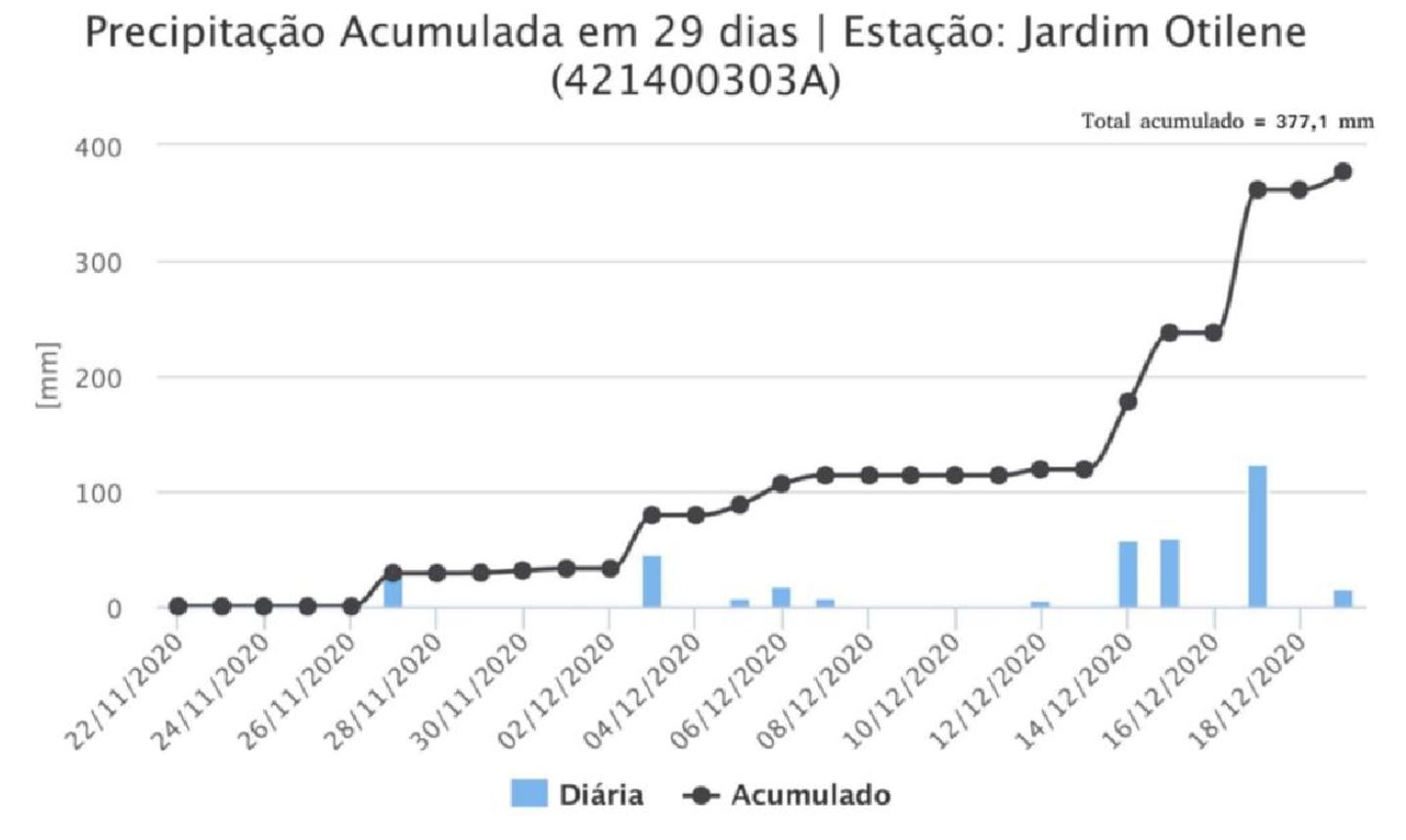
The monthly cumulative rainfall at the Jardim Otilene Station from 21 November to 19 December 2020.
.
In the eight days before the disaster, the total cumulative rainfall recorded at the site was approximately 260 mm:
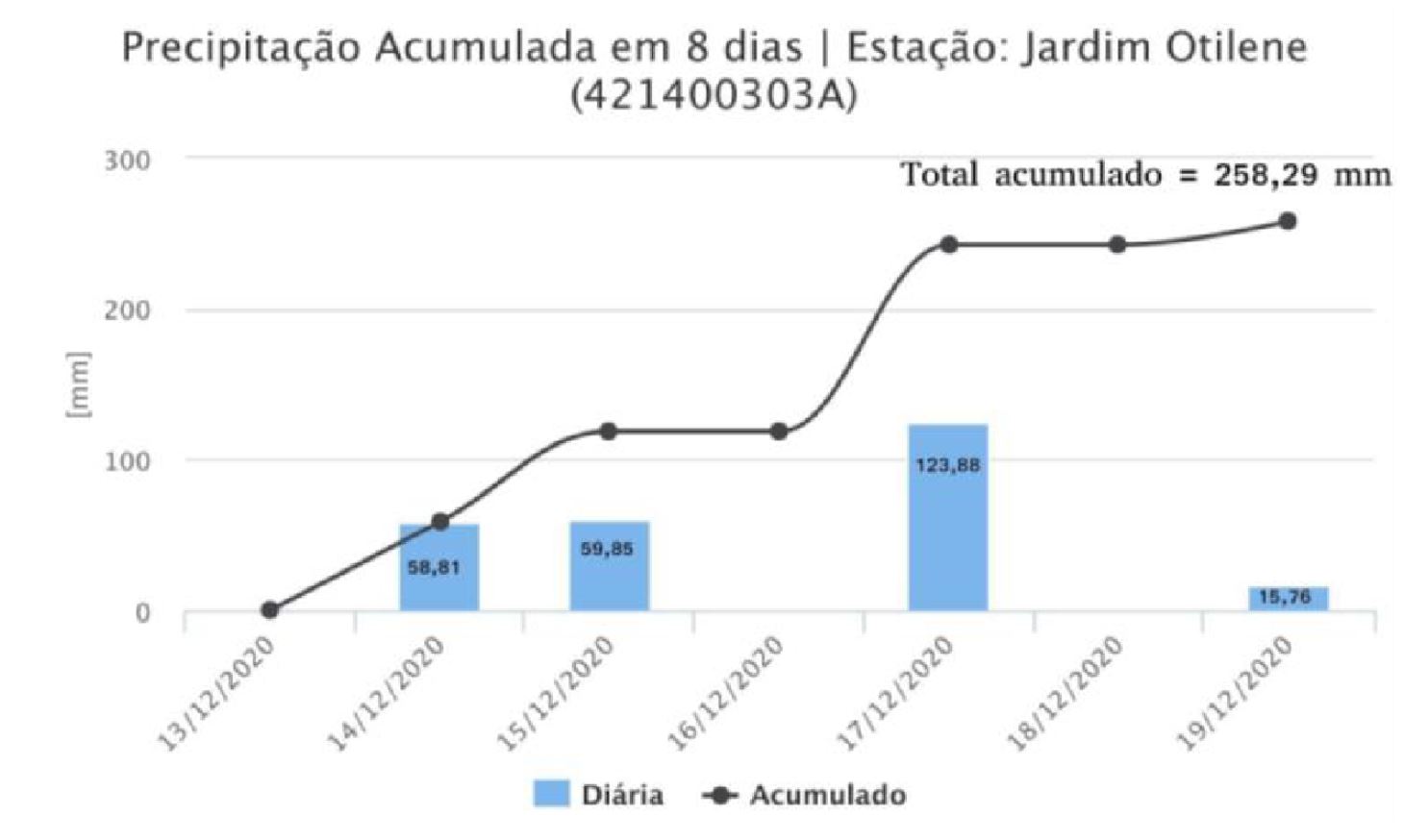
The total cumulative rainfall in Jardim Otilene Station for the period from 13 to 19 December 2020.
.
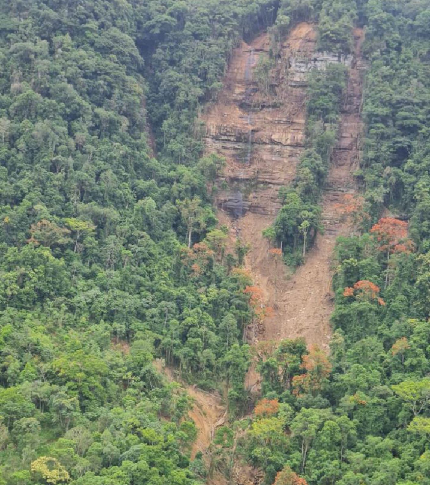
Most of the larger mass movements in the Presidente Getúlio region initiated as translational type landslides in the Palaeozoic sandstone escarpments. The dangerous geological processes identified in this event included landslides, rock falls, debris flow, floods and flash floods, mainly affecting the Revólver Creek valley in Presidente Getulio, and the Cobras Creek valley in the municipality of Rio do Sul. High-energy surface water flows, transporting logs, pebbles, sand, clay and debris, reached the lower portions of the valleys, causing destruction in rural areas and in the urban area of the city of Presidente Getúlio.
Consequently, several roads and bridges were destroyed, houses were damaged or destroyed and agricultural and industrial activities were impacted, achieved by these geological processes of high destructive capacity. The images below show some these events:
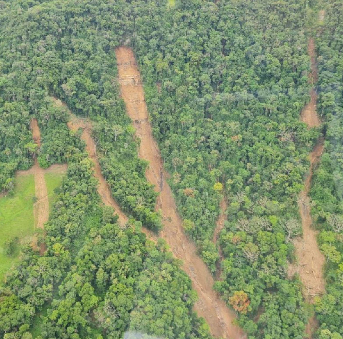
Landslides in the Revólver Creek valley. Photo by Renato Lima.
.
Landslides in the Revólver Creek valley. Photo by Renato Lima.
.
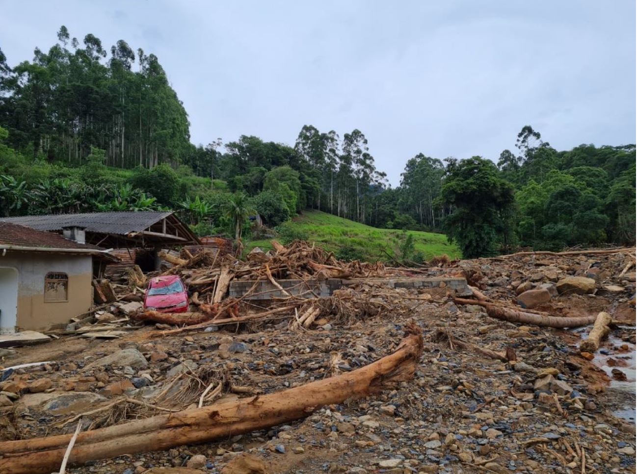
Damage caused by landslides in the Revólver Creek valley in Presidente Getulio. Photo by Renato Lima.
.
Acknowledgement
This report is partly translated from the information in the Mission Report (in Portuguese) of the Center for Scientific Support in Disasters (CENACID) to support the affected community in Presidente Getúlio. CENACID, led by Prof Renato Lima, from the Federal University of Paraná, is an organization that aims “to provide scientific knowledge when it is necessary to reduce the losses and suffering of society in disasters”.
 Dave Petley is the Vice-Chancellor of the University of Hull in the United Kingdom. His blog provides commentary and analysis of landslide events occurring worldwide, including the landslides themselves, latest research, and conferences and meetings.
Here is a HazMapper-Google Earth URL for folks who want to interactively explore this event. Thank you for writing about this @davepetley.
https://cmscheip.users.earthengine.app/view/hazmapper#lon=-49.62406884227742;lat=-27.08813012418148;zoom=13;dataset=0;prewindow=1.5;postwindow=2;maxCloudCover=0;slopeThreshold=0;eventDate=20201218;
Thanks for your insight and sharing the Google Hazmapper link. Impressive.. These same landslide/debris torrent racing stripes are so common on slopes with frequent intense rain events, on forested slopes esp in frequently rain soaked areas of BC and Alaska and where land surface/vegetation disturbance has occurred , glaciers are receding and step wise big change is the norm. The stripes and scars should be a warning of these hazards . Great display and use of satellite imagery overlays.
Sorry for the people impacted by these failures after heavy rain events.
Thanks for sharing information about this disaster @DavePetley.
Our group (www.ufrgs.br/gpden) worked collecting field information in the region few days after the occurred. As result, we prepared and published a technical report about it and shared it with municipalities and civil defense. Unfortunatelly it is ony in portuguese at this moment, but I can translate parts of it if some of you are intereseted.
The technical report is available at our website: https://www.ufrgs.br/gpden/wordpress/wp-content/uploads/2021/01/Relatorio-Desastre-do-Alto-Vale-do-Itajai-Dezmbro-de-2020.pdf
Additionally we prepared a database with tons of information about this disaster. If you want to access it, please let me know ([email protected]).