24 May 2021
Rest and Be Thankful: an update on the landslide mitigation works
Posted by Dave Petley
Rest and Be Thankful: an update on the landslide mitigation works
Yesterday, The Scotsman newspaper posted a long and detailed article about the ongoing attempts to manage the landslide problem on the A83 at Rest and Be Thankful. I have posted frequently in recent years about the landslide problems at this site, which is undoubtedly the most challenging landslide location in the UK at the moment.
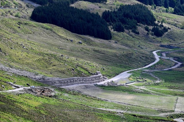
The article describes the new engineering works that have been completed to protect the diversion route lower down the hillside, the Old Military Road, which is brought into use when the main A83 route is unusable. The latest attempt to protect this road has involved the construction of a huge bund, 6 metres high and 180 metres long, on the upslope side of the Old Military Road, to capture debris from the slope above. The article includes images of this remarkable structure:-

The newly constructed bund to create a retention space for debris flows above the Old Military Road at Rest and Be Thankful. Image by John Devlin via The Scotsman.
.
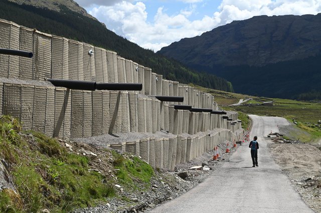
From the perspective of the road the structure looks like this:-

Detail of the newly constructed bund above the Old Military Road at Rest and Be Thankful. Image by John Devlin via The Scotsman.
.
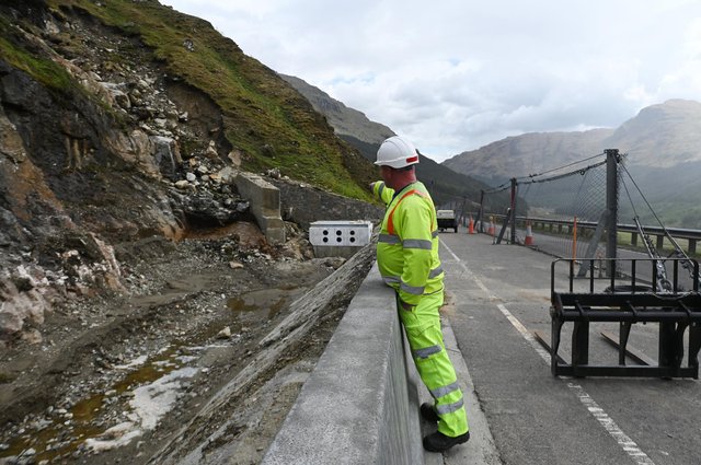
Meanwhile on the main A83 road itself, catch pits are being built on the upslope side of the road to try to retain mobilised debris, and multiple flexible barriers have been constructed. At one location a flexible barrier has been constructed along the centreline of the road itself to try to protect a part of the carriageway. I have not seen that approach previously:-

One of the catch pits and a flexible barrier on the A83 at Rest and Be Thankful. Image by John Devlin via The Scotsman.
.
The scale of these engineering works, and the construction of increasingly large structures in an area that is protected, illustrate the enormous magnitude of the challenges on the A83 at Rest and Be Thankful. Plans are progressing for the construction of an alternative alignment, but this will take several years to bring to completion. In the meantime, protecting the roads against landslides will be a mighty battle.


 Dave Petley is the Vice-Chancellor of the University of Hull in the United Kingdom. His blog provides commentary and analysis of landslide events occurring worldwide, including the landslides themselves, latest research, and conferences and meetings.
Construction of a barrier in the center of the road so that at least part of the road stays passable (and using the other half as an additional “catch pit” is a very nice application of a technique for system design which is called graceful degradation. ( The road transporting traffic is the “system” in this case).
Is that a permanent catchfence in the centre of the road, looks like it could be a temporary one to protect the road during the construction works?
Those Hesco gabions (well-known around the world for military barriers) are perfectly placed on the “old military road”.
…..developing some nice InSAR targets. Man-Made reflectors — not sure why we have not seen L-Band views of the slope, or even a “spec” C-Band results — tones of acquisition there available ….
Flexible barriers tend to deform when impacted. I’m not sure how passable the outside edge of that road will be if the barrier is hit. Would it have made more sense to place the barrier on the upslope fog line and a row of concrete traffic barriers along the centre line, just to maintain flow along the outside lane? I’m sure lots of thought went into this (much more than my 2 cents), so I’d be interested to know what the intent was.