16 July 2021
Inden: a river changing course, eroding an old channel and flooding an open cast mine
Posted by Dave Petley
Inden: a river rediscovering a previous course and flooding an open cast coal mine
The floods in Germany, Belgium and Netherlands this week have been truly catastrophic. The same storm system also caused flash flooding in London. It is likely that the this event will have triggered landslides, but we will need to wait to get more information when the priority is rescue and recovery. There are suggestions that an event has killed several people near to Cologne, but we await further information.
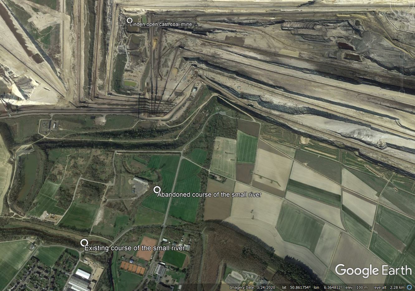
In the meantime, my attention has been drawn to a very interesting event at Inden in Germany, the site of a very large open cast coal mine. Here, the extreme rainfall has caused a small river to change course, partially flooding the mine. It is worth taking a moment to review the events. The Google Earth Image below shows the site – I have annotated the key features:-

The setting of the floods at Inden in Germany on 14 July 2021. Image from Google Earth.
.
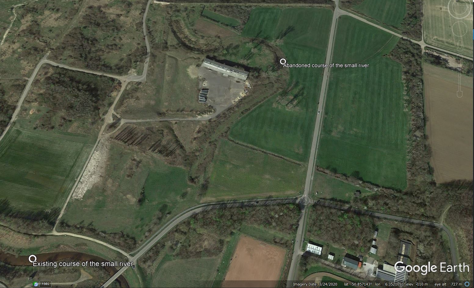
The pertinent features here are the small river flowing towards the north from the bottom of the image, and then swinging around to flow twowards the west (presumably rerouted around the mine), An abandoned river channel is clear, with a large bend around the building:-

The abandoned channel at Inden in Germany. Image from Google Earth.
.
In the rainstorms of 14 July 2021 the small river has burst its banks and reoccupied its former course. The effects are dramatic. This video captures the huge erosion that has occurred as the flood has occupied, and down-cut, its channel:
The floods happening all over germany right now are insane.
A the open coal mining operation in Inden for example, the entire river Inde has re-directed itself back into its former riverbed, and into the pit. They'll have a very nice lake soon that you can sail your boat on. pic.twitter.com/2sysznsM4P
— Cheetahs Gonna Cheet (@cheetah_spotty) July 15, 2021
.
The water has flowed into a very large open cast coal mine, causing serious damage. There are videos on Twitter showing thgis in action:
Bursted in inden, the river 'inde' floating into coal mine.. Which is filled in 24 hours pic.twitter.com/IYH4gAFxjb
— Jana Schiffer (@SchifferJana) July 15, 2021
.
#tagebau #inden von #rwe geflutet #KohleArmin #LaschetLuegt #KlimakriseISTjetzt #LaschetVerhindern #LaschetWelle pic.twitter.com/61Su9wcyLs
— #Hambi bleibt (@DanniPilger) July 15, 2021
.
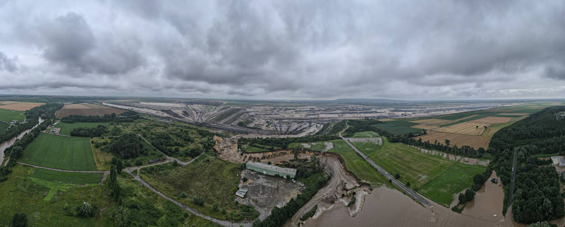
And this image shows the aftermath:-

The aftermath of the flooding event at Inden in Germany. Image by Guido Jansen via Aachener Zeitung.
.
For a river to change channel during a flood is not unusual. In this case, the base level of the channel has been reset by the mining operations. The erodible materials then allowed the river to down-cut, creating the new, deeply incised watercourse.
The European floods are another example of global heating playing out in real time with tangible impacts. The last few years have demonstrated that regional effects are already intense, generating extreme temperatures and extreme rainfall, with a lot more heating baked into the system. I can only add my agreement to that of others, as expressed in a BBC article today – we don’t know exactly how much trouble we are in, but we do know that it’s very bad indeed.


 Dave Petley is the Vice-Chancellor of the University of Hull in the United Kingdom. His blog provides commentary and analysis of landslide events occurring worldwide, including the landslides themselves, latest research, and conferences and meetings.
Another nice example from floods in Germany in city of Erftstadt. Erosion into Open pit Sand mine.
https://twitter.com/mahrko/status/1415961533780267008?s=21
The landslide reported at Erftstadt-Blessem appears to be at Blessem (rather than Erftstadt) and looks to be a retrogressive event that has cut back from a quarry around 500m to the north of the town. The quarry is over 60m deeper than the floodplain and I assume that this, plus the laterally continuous floodplain sediments have enabled the failure to propagate such a distance.
Given that most of these failures are likely to have some retrogressive component once quarry sides fail, it does raise the question as to whether landslide risk assessments need conducting in settlements in flood-vulnerable settings to identify whether this could happen again. There’s also the residual risk that the failure could remobilise and cut further into the town.
Sorry Dirk, missed your post!
A whole canyon carved at the speed of falling water.
Unfortunately, such tragic examples as this elucidate the potential for catastrophism occurring in even seemingly innocuous landscapes.
A question about the materials eroded by the river. Were they natural sediments or waste mining materials accumulated during time?
That fish-eye lens photo at the end of the article kind of gives me an idea for a new type of ‘Flood Defence’. If you look closely there’s no flooding going on past the breach into the quarry.
Build an overflow channel from rivers to all the nearby Open Pit Quarries along it’s path. The Government could then pay the Quarry owners to use said quarry as a catchment area for a rivers flood waters, the water can then be pumped out at a later date once the river level has receded.
Far better than building walls along a river, as that just funnels the flooding further downstream and makes it worse and higher where it DOES flood (due to the river having less of it’s floodplain to spread out on…) :/
You are correct that the mine rerouted the river in about 2005 around the current mine. That old channel was the previous route.
This bears some resemblance to the 1988 flood into St Aidan’s opencast mine from the River Aire not far from Leeds. Except on a much bigger scale…
I wonder if this unintended river diversion saved the downstream towns?
Someone I once met (this guy https://www.engineersaustralia.org.au/sites/default/files/content-files/2016-12/john_argue_hall_of_fame_document.pdf ), spent much of his life campaigning against the creation what he called “freeways for water”. In the UK we are now trying to turn this legacy around with the SUDS policy.
Germany seems to have gone for creating ‘autobahns for water’ – big time. Now we see the disastrous consequences.
A nice aerial view from before.
https://www.rwe.com/en/our-portfolio/our-sites/inden-mine-site
John, yes we are slowly implementing those systems in Aus, but extreme flood events are significantly beyond the scope of any but the most extreme man-made diversion.
It’s all about increasing the concentration time – and it must be done as far up in the catchment as possible. By the time the water reaches the main river channel there are far fewer man-made options available for flood control.
In Europe, the EU paid farmers to remove the hedgerows – thus making the agricultural catchments much more prone to flash-flooding. But no measures (e.g. attenuation dams) were put in place to counteract the effect of hedgerow removal on the concentration times of the catchments.
The last panorama photo in this article shows a retrogressive event like the one Andy M refers to in his comment above: flooded fields now draining into a broccoli-shaped collection area like a lit fuse following the cord.
Almost happened in Australia last month:
Yallourn mine operator pledges flooding solution amid state of emergency – ABC News https://www.abc.net.au/news/2021-06-18/scramble-to-solve-yallourn-mine-flooding-threat/100226204