
17 May 2011
Attabad landslide – Geohazards 5 presentation
I am today presenting a keynote lecture at the Geohazards 5 conference in Kelowna, British Columbia in Canada. The title of the talk is “Attabad landslide crisis in Hunza, Pakistan – lessons for the management of valley blocking landslides”. The written paper is available here:
Petley, D.N. 2011. Attabad landslide crisis in Hunza, Pakistan – lessons for the management of valley blocking landslides. In: Proceedings of the Geohazard 5 Conference, Kelowna, Canada: 11_01 Geohazards 5 Attabad final
The presentation is available as a PDF here: 11_05 Geohazards 5 keynote Petley 1 or as an Authorstream presentation, from which the powerpoint file can be downloaded.
Meanwhile, The Nation is reporting that the estimated time to restore the road is “more three years”, and notes the likely impact on cross border trade with China.
Landslide wave video
Thanks to Tom Hodgson for the heads-up on this one.
Youtube has a video of a wave generated by a landslide in Porcupine Bay in Washington State in 2009. Whilst the news report is a little breathless, the footage of the wave is good:
The Sliding Thought Blog, which now seems to be defunct (?), has a good description of the event. Kudos to the camera woman for her rescue – the two boys survived with only minor injuries.
16 May 2011
Mountain hazards in the Himalayas – Attabad, GLOFS and earthquakes
Two items of interest to those of us who work in the Himalaya mountain chain have cropped up this weekend:
1. Attabad continues to confound all management approaches
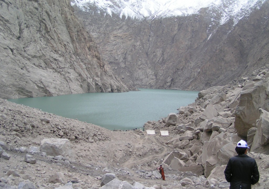
The Express Tribune in Pakistan has an article today on the continued problems of managing the Attabad landslide in Hunza, Pakistan. This article focuses on the essentially unsuccessful attempts to deepen the spillway, and thus reduce the water level, this winter. In particular, it quotes Gilgit-Baltistan (G-B) Chief Minister Mehdi Shah as follows “The boulder is too big to be moved using controlled blasts”. The issue appears to be that a large boulder in the landslide debris has resisted the excavations. This could be good or bad news, depending on the exact circumstances. It could be that this boulder will prevent collapse of the dam in the long-term; alternatively, it could be that the water will find away around the blockage. More detail is needed; unfortunately there is still a lack of clarity as to what is going on. Given that the snowmelt season is now beginning, the concerns of the local population are understandable.
Meanwhile, the privations of the local population continue. The Pamir Times is carrying an article about a protest that is ongoing in the area. The key issues appear to be the lack of the promised compensation for the displaced people and the lack of progress in deepening the spillway.
2. Earthquake and GLOF danger in the Himalayas
Meanwhile, the work that we have been doing on seismic risk in the Himalayas is nicely supplemented by an article on the BBC website that highlights work at various institutions in South Asia. The article nicely emphasises the really profound risk of a devastating earthquake in this area, but the key emphasis is the potential for a seismic event to trigger the collapse of rapidly growing glacial lakes in the mountains, unleashing potentially catastrophic floods down the valleys below. The risk is very real.
The level of preparedness for a major seismic event in the Himalayas is deeply concerning. The magnitude of the hazard has been known for a decade or more. The lack of progress is desperately frustrating.
15 May 2011
Images from the Sichuan earthquake zone
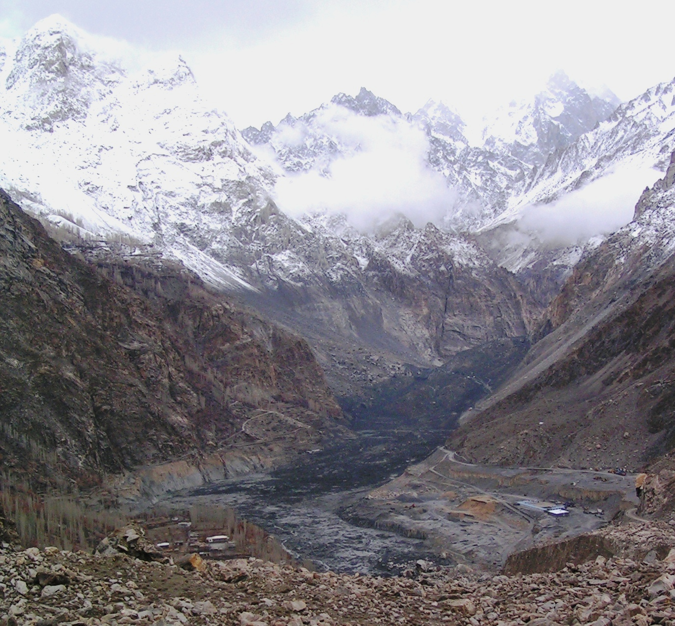
On Saturday the organisers of the conference in Chengdu to mark the 3rd anniversary of the Sichuan Earthquake kindly organised for us to spend a day in the Wenchuan earthquake area. The main focus was on the debris flows that have plagued this area since the earthquake; unfortunately this is likely to be the case for years to come. With typical bad timing, the SD card on my camera failed, so I was left with photographs from my useless iPhone (surely the most over-rated piece of technology of the modern age!). Nonetheless, I thought I’d post a few images here.
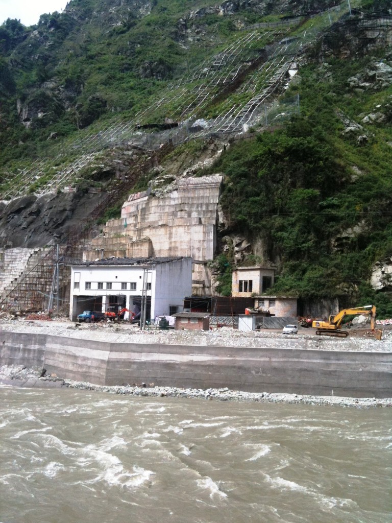
First, in many locations desperate measures are needed to protect infrastructure. Here, an electricity substation is threatened by slope problems, such that extensive works have been needed on the slope. These have included the construction of a retaining wall, dentition, and the construction of a shelter above the building. If you look carefully you will see that tyres have been put on the shelter roof to cushion the impacts from debris:
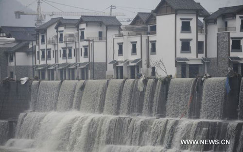
This is the newly constructed town of Yingxiu, replacing the devastated urban area. The scale of the reconstruction is hugely impressive:

However, this area was badly affected by flooding in August 2010, when a landslide blocked the Minjiang River, causing considerable damage to the new town (image from here):
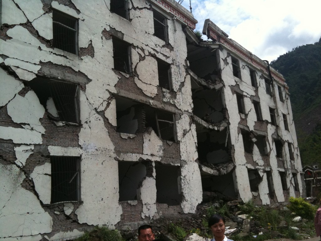
At the moment many of the buildings are empty; it would be interesting to know if worries about flooding are part of the reason. Meanwhile, in the town the Secondary School has been preserved as a monument to the earthquake. The site is very sobering:
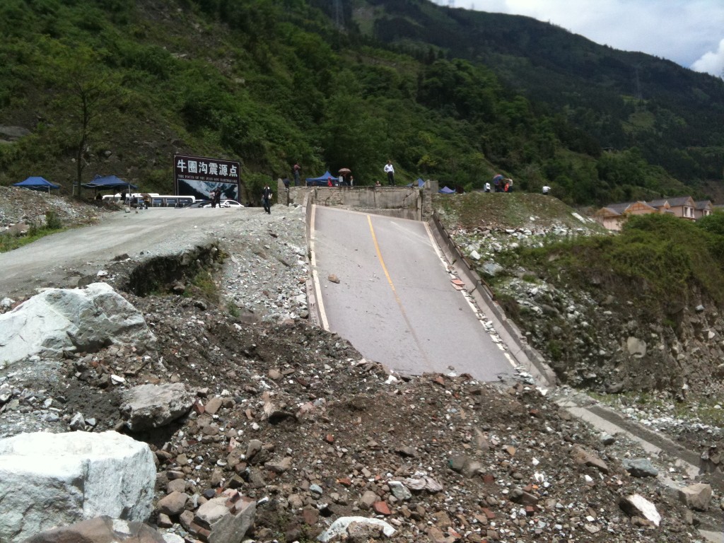
Upstream a section of broken road remains in place, whilst behind the disaster tourism is in full swing, with stalls selling pictures and VCDs of the impacts of the earthquake:
13 May 2011
The third anniversary of the Wenchuan Earthquake – loss of life in seismic landslides
Yesterday, (12th May) was the third anniversary of the Wenchuan Earthquake. To commemorate this event, the Chengdu University of Technology has been organising a conference examining earthquake induced landslides. My presentation is in the morning session today and will focus primarily on the loss of life in landslides triggered by earthquakes. In the talk I will also mention our Nature Geoscience paper, which will be published on Sunday,which looks at the mass balance of the mountain chain. I will blog about this (very exciting) paper on Sunday when it has been published.
The loss of life component of the talk is included in the PDF that is available here: 11_05 China keynote Petley blog
I will try to describe the key aspects of this talk below.
Regular readers will be aware that one aspect of my research is to collect data on the occurrence of landslides that kill people worldwide. I have been doing this since September 2002; occasionally I publish this data on this blog. In this presentation I examined this data to look at the occurrence of landslides triggered by earthquakes. Overall in the period from 1st September 2002 to 31st December 2010 I recorded a total of almost 82,000 fatalities from landslides. This figure shows the cumulative total of fatalities during this period:
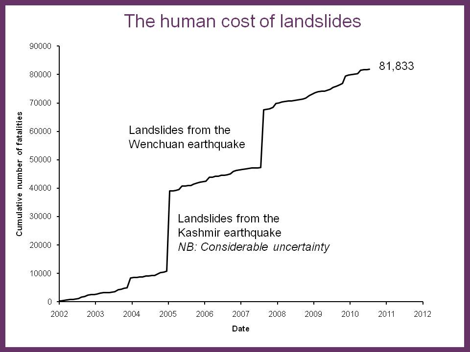
You will see that the data are dominated by two earthquake events – the Kashmir earthquake of 2005 and the Wenchuan earthquake of 2008. Unfortunately, there is some uncertainty in terms of the actual losses from landslides in the former event; the best estimate according to official figures is in the order of 26,400 lives. The published figure for the Wenchuan Earthquake is about 20,000 fatalities.
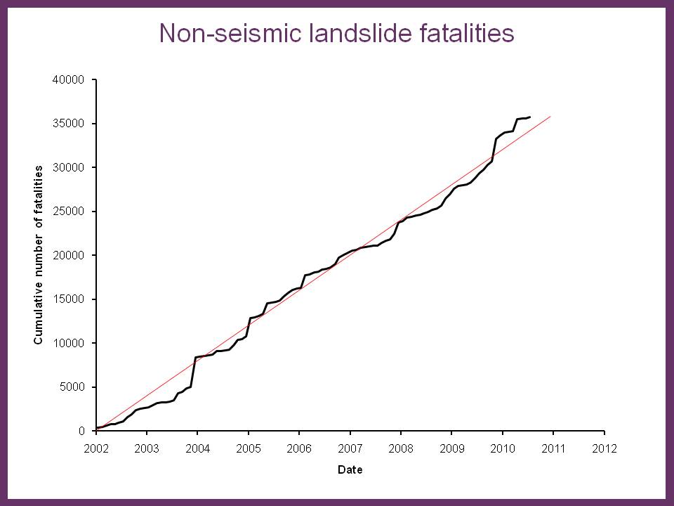
Interestingly the trend of losses with time from rainfall induced landslides is approximately constant with time:
The cumulative trend for earthquake-induced losses shows the impact of the two large events, but in fact over this period a total of 32 earthquakes that triggered landslides responsible for fatalities have occurred:
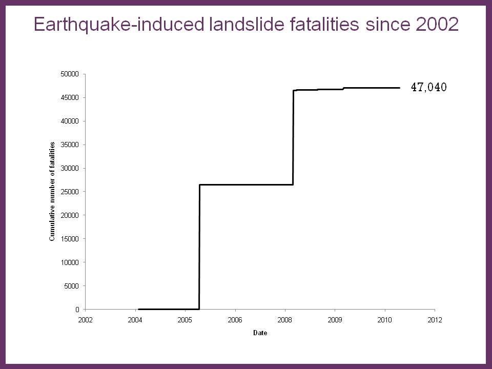
Interestingly, this means that more than 50% of the people killed by landslides during this period died in events triggered by earthquakes. This of course emphasises the very urgent need to improve our understanding of seismically-triggered events.
The data (in closed – i.e. black – symbols below) can be combined with information from the literature (the open symbols) to provide an initial examination of the relationship between the number of landslide-induced fatalities and the earthquake magnitude. There is huge scatter in the data, but perhaps two thresholds can be drawn. The first, the orange line, represents the limit for 90% of events; the second, the red line, represents the maximum boundary for all events:
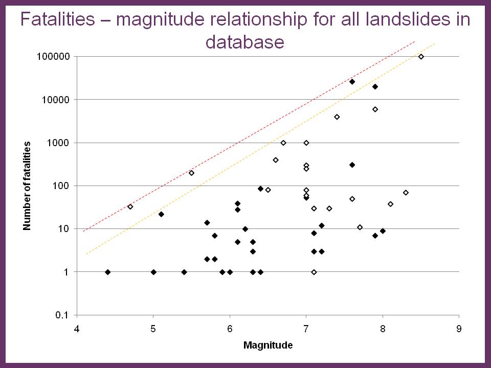
This analysis is somewhat tentative at the moment, and more work is needed.
Finally, much is (rightly) made of the increase of landslide losses in the aftermath of earthquakes. I have looked at my data for Sichuan Province before and after the earthquake. The data do seem to suggest a marked increase in recorded fatalities:
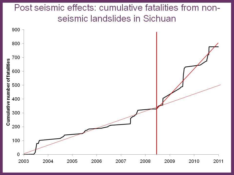
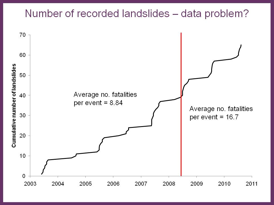
This implies that there has been an additional c.300 fatalities from landslides in the aftermath of the earthquake, although more work is needed on this. Interestingly, there is no obvious increase in the number of fatal landslides occurring, but rather an increase in the average number of fatalities per event. This may imply that in the aftermath of the event I am failing to record the smaller landslide events:
All of this serves to emphasise that the data presented here probably consistently under-estimates the true costs of landslides. Actual losses are undoubtedly rather higher, although I must emphasise the uncertainty associated with the loss of life from the large earthquake events.
Comments and thoughts are welcome!
11 May 2011
Strange goings-on in Rome
Various news agencies (e.g. the BBC) are reporting a strange story this morning about concern in Rome over a “cataclysmic” earthquake. The reports note that a rumour has swept through the city that there will be a devastating earthquake on 11th May 2011; the result is that at least some of the population is expected to stay away from Rome on that day just in case.
The origin of the rumour appears to be an urban myth about a prediction made by Italian seismologist Raffaele Bendandi, who promoted the idea that planetary configurations play a key role in determining the occurrence of large earthquakes. Although Bendandi died in 1979, he reportedly made a prediction of a large earthquake in Rome on this day, and hence the concern.
However, of course there is no scientific basis for this prediction. Indeed, even the prediction itself is in doubt – Bendandi reportedly burnt his notes and records before he died, leaving no more than unclear, fragmentary evidence of his predictions. Scientifically-invalid stories about the role of planetary alignment on earthquakes continue to do the rounds; the last big scare was in June 2010; as usual nothing occurred of course. The frustration is that there is no data to support the idea that planetary alignments are somehow related to earthquake triggering. And even if they were, it is far from clear as to why an earthquake would occur in Italy rather than in one of the many other areas with high levels of stored earthquake strain energy. And even within Italy, the identification of Rome is particularly perplexing – the national seismic hazard map of Italy below (from here) shows that parts of country are vulnerable to earthquakes, but that Rome is not an area of particularly high seismic hazard by Italian standards:
As usual with such stories, the real issue is the distraction that this sort of pseudo-science generates. Our emphasis should continue to be on risk reduction through understanding seismic hazard, measures to increase resilience (such as the implementation of building codes), preparing potentially-affected populations and generating emergency plans for when events occur. Prediction is not the answer, even if it were possible.
5 May 2011
New presentation – Climate Change in Gilgit-Baltistan: impacts on humans and hazards
Today I am giving a presentation at a UNPO meeting in Brussels entitled: Gilgit Baltistan: A Critical but Unknown Pivot of South Asia under Threat. My presentation is entitled “Climate Change in Gilgit-Baltistan: impacts on humans and hazards”. The talk examines the range of natural hazards in this area of NE. Pakistan, including the potential effects of earthquakes and climate change, and it highlights of course the Attabad landslide. A pdf of the presentation should be available here: 11_05 EU Gilgit Petley
4 May 2011
New landslide video: railway washout in Canada
Thanks to several people who sent me a link to this Youtube video of a railway washout occurring at Stackpool in Ontario, Canada in the middle of last month:
2 May 2011
Wildfire at Liathach in Torridon
Over the weekend Michele and I popped up to the classic geological area of Torridon in western Scotland to go walking for a few days. We were fortunate to be greeted by glorious weather – the Highlands are hard to beat in such conditions – which was quite wonderful. A remarkable observation was just how dry the ground is at the moment – all of the UK is having a period of exceptionally dry weather that is forecast to persist until late this week at least. Precipitation in the last month has been particularly low, in a month that is typically showery, resulting in very dry conditions underfoot. The consequence in Scotland is that there is a high vulnerability to wildfires as the vegetation dries out. The heather and gorse found in the highlands, and the peat layers that sit below in the valley floors – are quite vulnerable to fires.
Over the weekend a number of fires broke out across Scotland, and with the weather set fair more are likely over the next few days. In Torridon a large fire started on Saturday on Liathach that quickly swept up the mountain to form two fire fronts burning to the east and the west. I took this image of the fire from the other side of the valley on Saturday evening using my iPhone:
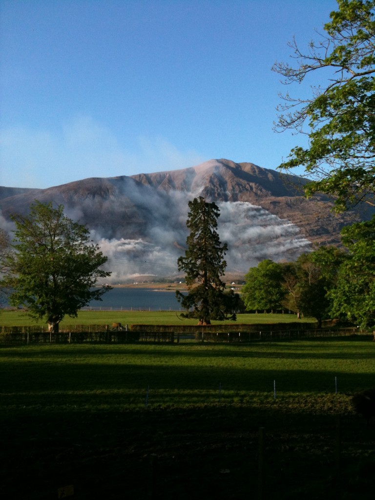
The eastern fire front is on the right side of the image, and the western to the left. At the foot of the slope the village of Torridon is visible – the fire came perilously close but the houses were spared. A day later the fire was still burning and had extended considerably. There are some amazing shots of the fire on Steve Carter’s website. The upshot of this fire will be damage to a large area of vegetation, which is very sad to see.
28 April 2011
Mining-related landslides in the Philippines
A key human cause of landslides around the world is mining. This problem is exacerbated in areas in which mining activities are uncontrolled and unregulated, a particular issue in many less developed countries. In recent months there has been a spate of mining-related accidents in Mindanao in the Philippines. Many such landslides probably go unreported, but for 2011 my database includes the following events:
11/03/2011 Pantukan town, Campostella Valley 1 fatality 5 injuries
30/03/2011 T’boli town , South Cotabato province, Mindanao 3 fatalities 2 injuries
02/04/2011 Tampakan area, Mindanao 4 fatalities 2 injuries
22/04/2011 Kingking villag, Pantukan, Mindanao 24 fatalities 13 injuries
The root cause of the problem is that this area has extensive small-scale and unregulated gold mines. Whilst the rewards are potentially large, the risks associated with mining gold in a deeply weathered landscape that is prone to both earthquakes and intense rainfall are clear. In addition, the miners (which include children) tend to live on the hillsides close to the mine workings. There is a very evocative gallery of images of such a gold mining community in this area at the following location: http://www.photoblog.com/undergroundpix/2008/07/23/.
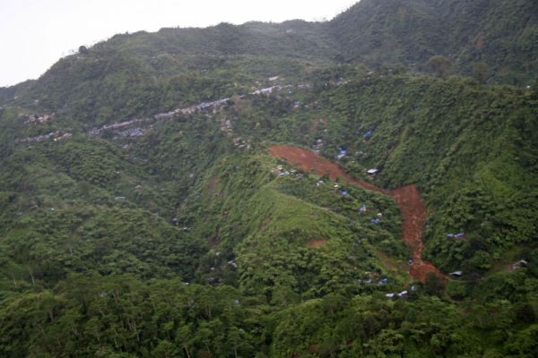
As you will see from the above, the most recent landslide occurred in a mining camp in Pantukan last Friday, killing 24 people living on the hillside. This image, included in this news report, shows the landslide and the adjacent hillsides:
There is a good gallery of images of the landslide here as well.
As the image above and the gallery illustrate, recovering the victims of this landslide in such a landscape is exceptionally challenging, with news reports suggesting that houseflies are providing a key tool to identify the location of the bodies, whilst the anguish of being the parent of men killed, missing and injured in the landslide is well-described in this report. Of course the longer term problem is how to reduce the very high losses that these landslides are inflicting. This is driving a wave of concern in the Philippines about these mining activities. At the moment there appears to be two responses: First, there are attempts to relocate people living on the most dangerous slopes. This is currently concentrated mainly on the existing landslide site, although attempts may be made to extend this into other areas. Second, a temporary suspension has been placed on small-scale mining activities in this area, but enforcing this ban is of course very difficult.
The bottom line here is similar to the one that we recently highlighted through our NERC-ESRC project in rural Nepal. This is that the population is exposed to a wide range of risks, of which the day-to-day perils of food security, access to clean water, availability of health care, access to education, and a stable income dominate. These people choose to put themselves at greater risk from mining-related and landslide accidents in order to mitigate those daily threats. This is an entirely rational response. So, reducing mining-related landslides requires a coordinated approach that also addresses these everyday threats. The danger is that in unilaterally closing the mines and relocating the population, their everyday risks will increase, with outcomes that are even more detrimental than the landslides. If ever there is a need for joined-up thinking it is here.
 Dave Petley is the Vice-Chancellor of the University of Hull in the United Kingdom. His blog provides commentary and analysis of landslide events occurring worldwide, including the landslides themselves, latest research, and conferences and meetings.
Recent Comments