
19 September 2011
Update on the earthquake in India, Nepal, Bhutan and Tibet
As expected, the news emerging from India, Tibet, Nepal and Bhutan is of increasing losses from the earthquake yesterday, and of considerable disruption from landslides. It does appear that the timing of the event at the end of the monsoon has increased landslide impacts, exacerbated by ongoing heavy rainfall in the area. The combination of this rainfall and ongoing aftershocks is likely to render the recovery operations very challenging indeed. Expect the losses to creep upwards during the day as remote areas are slowly accessed. Unfortunately, the weather forecast for the area is poor:
Widespread rainfall would occur over Sub Himalayan West Bengal & Sikkim and fairly widespread over Gangetic West Bengal during next 48 hours.
Isolated heavy to very heavy rainfall would occur over Sub Himalayan West Bengal & Sikkim and isolated heavy over Gangetic West Bengal during next 48 hours.
The impact of the earthquake appears to be as follows, based on reports that are slowly emerging from the affected countries:
Bhutan
The area of Bhutan affected by the earthquake is very isolated, so reports are quite sketchy at present. Kuensel online reports:
Full extent of damage not known due to a partial collapse of the communication system…While no casualties have been reported so far in Bhutan, cracks to buildings were reported in some parts of the country. In Thimphu, the referral hospital’s emergency ward saw three trauma cases, and two cases of disjointed shoulders of people who had fallen during the tremor.
Some landslides have been reported away from the main affected area:
A massive landslide in Phuentsholing buried a Spark car, which was on its way to the hospital. The driver managed to escape.
And
..four roadblocks caused by falling debris reported on the Chukha – Phuentsholing road.
Given the distance that these sites are from the epicentre, we are likely to see much more profound damage in the northwest. It may well be another 24 hours before the real picture in Bhutan becomes clear.
India
Several news reports in India point to the impact of landslides, and the role that they are playing in hampering the rescue efforts. For example, Indian Express notes that:
Rain and landslides were blocking rescue efforts of hundreds of workers searching for survivors of a 6.8 magnitude earthquake that jolted a remote the north and northeastern India, killing at least 40 people…Around 400 personnel of National Disaster Response Force (NDRF) and a team of 20 doctors, sent to Sikkim for rescue and relief operations, have not been able to yet reach the quake-hit areas due to blockade of roads following landslides, officials said today.
Meanwhile, the loss of life to date appears to be about 36 people, including 25 in Sikkim and a further 11 in Bihar and West Bengal.
Nepal
Nepal News reports eight fatalities in Nepal, and many more injured. This includes three people killed when the boundary wall of the British Embassy in Kathmandu collapsed into the road (an absolute tragedy for all involved); one person killed by falling debris in Bhaktapur; two people were killed in Dharan in a house collapse; one person killed by falling debris in Dhankuta; and one death in Sankhuwasabha. Notably there is comparatively little information about the far northeast of the country.
Tibet
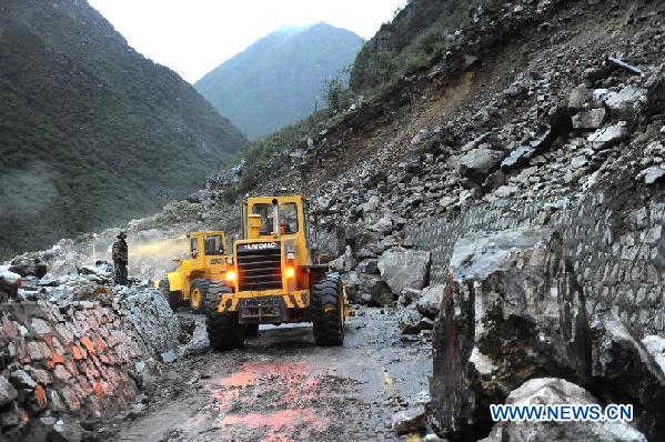
Xinhua reports seven fatalities in Tibet, and 22 people injured, all in the border region of Yadong County. It also reports that:
“The earthquake has caused hundreds of landslides that have disrupted traffic, power and water supplies, as well as telecommunications in Yadong County, Tibet”.
Indeed, the news report is accompanied by this image of clearance operations:
http://news.xinhuanet.com/english2010/china/2011-09/19/c_131146663_2.htm
Synthesis
As expected (but not widely appreciated) landslides are proving to be a major issue in this area in the aftermath of the earthquake. It should be possible to ascertain the approximate extent of the area of landsliding from the distribution of the aftershocks (following the method of Tatard and Grasso 2011), but so far I cannot find a good aftershock map or dataset (anyone know of one?).
This event is undoubtedly very sad, but perhaps most importantly should serve as a wake-up call to the magnitude of the seismic risk in the Himalayas. This earthquake is much smaller, and in a much less densely populated area, than the large event that we fear in the Himalayas. It is surely time to make a major effort to build resilience to such an event in this area.
Comments and updates welcome.
18 September 2011
First news – the earthquake in India, Nepal and Bhutan this afternoon
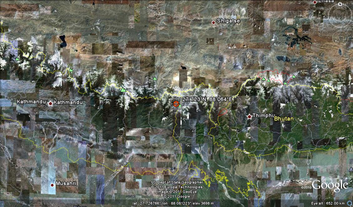
At 12:40 UT (18:40 local time) today an earthquake struck Sikkim in northern India, producing significant shaking in Nepal, India and, probably Bhutan. According to the USGS information page for the event, this is a magnitude 6.9 event at a depth of about 20 km, though note that this will probably change slightly as better data become available. The epicentre is located as shown on the map below:
Although this event occurred sufficiently far to the north to be in a lightly populated area, there may be a not inconsiderable level of loss associated with this event. The earthquake was sufficiently shallow that the peak ground accelerations may be quite high, and we might expect substantial topographic amplification and other site effects. In addition, the buildings and infrastructure in this area are highly vulnerable, and landslides are a substantial problem. Furthermore, the timing of the event, in the late stages of the monsoon, may well mean that the ground is already wet, making landslides more likely.
At the time of writing, some loss information had come in, but given that it is now night-time in this area, and communication links are likely to be highly disrupted, this should not be seen to be a guide to the true level of damage. News reports from the area suggest 16 fatalities so far, but again this should not be considered to be a reliable guide to the likely level of loss.
Two resources that people may find useful are:
1. The recent report that we wrote about building resilience to earthquakes in rural Himalayan populations, and the need to build resilience (this study was undertaken in north Nepal);
2. The wonderful Save the Hills blog, which documents landslides in Darjeeling.
I’ll blog later as more info becomes available. Comments and thoughts welcome. My work email is not working, but I can be contacted on: [email protected]
16 September 2011
The new UK Government Humanitarian Policy
A few months ago I featured the UK Government’s response to the Ashdown report, which sought to review the ways that Britain provides assistance to both slow onset and sudden crises, including both social (e.g. conflict) and hazard related (e.g. earthquake) events. Today, DfID (the UK Government department responsible for foreign aid) released its new policy statement on this topic, providing details of both priorities and modes of operation.
Overall, I think that this is a very positive development, and there is much to cheer in the document. The thrust is set out in the Foreward by the Secretary of State, Andrew Mitchell, who notes that
“Lord Ashdown’s report was clear: we will achieve far more in the long run if we pull together and collectively channel our efforts through a coordinated international system. Governments across the globe must share the burden of helping those in humanitarian need. We will work first and foremost through the UN, lending our full support to its Emergency Relief Coordinator, Baroness Amos, as she strives to help the UN-led humanitarian system to reach its full potential.”
I am not entirely sure how this squares with the Government’s announcement in March this year that “The United Nations International Strategy for Disaster Reduction (UNISDR) has not performed its international co-ordination role well. The UK will still be a member of UNISDR as it is part of the UN Secretariat, but DFID will no longer provide additional voluntary funding. This funding averaged £0.9m between 2002 and 2010” (see a detailed discussion here), but presumably this indicates that alternative mechanisms will be found (the same document was complimentary about UNDP and GFDRR). The new policy document does talk about the need to improve UN leadership and coordination; it will be interesting to see how this might be achieved.
There are a number of other interesting aspects of this new policy, of which I will highlight three key ones:
The emphasis on resilience
There is a very strong emphasis in the document on the idea of building resilience to crises. Resilience is a rather vague term, but the UN (ironically through ISDR) has usefully provided a definition and a clarifying comment that applies in this context:
“The ability of a system, community or society exposed to hazards to resist, absorb, accommodate to and recover from the effects of a hazard in a timely and efficient manner, including through the preservation and restoration of its essential basic structures and functions.
Comment: Resilience means the ability to “resile from” or “spring back from” a shock. The resilience of a community in respect to potential hazard events is determined by the degree to which the community has the necessary resources and is capable of organizing itself both prior to and during times of need.”
It can be seen that resilience is a broad concept, but it implies a high level of anticipation and planning for potential crises. Building real, meaningful resilience means carefully targeted programmes that are built on an awareness of threats, and it requires action at multiple levels. Thus, resilience is usually built upon a foundation of activities that range from national policies through community groups to individual households. Resilience requires that the portfolio of threats facing a community are understood and addressed. This is far from straightforward, but it is achievable with care. It is a good aspiration to have.
The research – humanitarian interface
The policy makes it clear that there will be a renewed effort to invest in research and innovation. This is welcome and of course sensible. The main component of this part of the document seems to be around policy and practice, which again is not unwise. However, to accord with the emphasis on resilience above, the research agenda will need to be wider than is implied here. Let me illustrate that with an example of building resilience to natural hazards in rural Nepal, which we have just studied in a NERC-ESRC funded project. To build resilience in these communities research will be needed into the hazards themselves (e.g. what magnitude of shaking might we expect in an earthquake; how likely is it to occur?); the consequences (how many buildings would collapse, and where; would the roads be blocked by landslides; will water supplies be affected?); and the effectiveness of various responses (could we fly in aid or would it need to be transported by road; are we better to send doctors or search and rescue teams?). Of course, that is not to say that research into effective mechanisms to build resilience isn’t needed as well, but there must be a balance.
The second key point here is that there is a need to recognise that DfID can get a great deal more if it connects properly with both existing research programmes, and with those planned by other organisations. Again, an example is the NERC-ESRC programme, recently launched, entitled “Increasing Resilience to Natural Hazards”. This will fund two large consortium projects, one on each of earthquake and volcanic hazards, with a very strong emphasis on end-user engagement. This is an excellent initiative. Last week, I attended a Town Meeting in London to discuss the programme. Present were representatives from universities, research organisations, NGOs, government departments and the Research Councils. A representative from DEFRA (the UK Government department responsible for the environment and for agriculture, amongst other things) spoke about the importance of the research base for her department. According to the delegate list that was circulated, no representatives from DfID were present as far as I could tell. Now, of course, there are numerous reasons why this might be the case, and I do not want to criticise, just to emphasise the importance of joined-up thinking and maximizing opportunities.
Actually, this comes at a good time in the UK research sector, as universities are responding to a very strong push from the government to maximise the impact of our research. Thus, universities are open to (indeed are enthusiastic about) sharing research with organisations such as DfID. In turn, DfID need to find mechanisms to allow this to occur, and to influence the trajectory of research that they are not directly funding.
The key to this is of course this statement in the document:
“The UK will establish a ‘virtual’ humanitarian research and innovations team, under the direction of DFID’s Chief Scientific Adviser. The team will regularly review existing approaches and identify gaps in the humanitarian and resilience knowledge-base. In consultation with other donors and UK partners, the team will commission new research and support innovations to strengthen the UK’s resilience and humanitarian response.”
Whilst this is a good idea in principle, the key will be to get this new team operating properly, including drawing in suitable advice and expertise from within the research community, and engaging with researchers across the disciplines. I will watch with interest to see how this develops.
The capacity to respond to humanitarian crises
Perhaps the most enigmatic aspect of this new policy is the one that says:
“we need to increase our capacity, expertise and improve our ways of working across government, to meet the resilience and humanitarian challenges of the future.”
and
“Continue to help strengthen UN agencies in their roles as leaders of the international humanitarian system, and support the Red Cross and Red Crescent movement and the NGO community”
This is of course reasonable, and there can be little doubt that this is needed. However, this statement seems remarkably lacking in detail or direction beyond a statement that DfID will”Expand the number of humanitarian professionals within the UK Government, and designate a Director General to provide senior leadership to the government’s humanitarian work”. This is actually a complex issue that cuts across many areas of government – for example, what will be the responsibility of the armed services in responding to humanitarian crises? The Ashdown Review provided some detailed recommendations in this area (see page 48 of the report here), including for example:
- Change the funding model to achieve greater preparedness, pre-crisis arrangements, capacity, performance and coherence
- Design fast and flexible funding models for emergency responses
- Use all new funding models to enforce standards and link funding to performance
- Develop and deploy niche capabilities in a more focused way where they add value
- Continue and expand the surge of UK contracted personnel into the international system
- Convene and lead a standing cross-government emergency mechanism for mega emergencies, using the authority of the National Security Council.
Whilst aspects of this are touched on elsewhere, there is a lack of clarity here as to how it will be achieved. I worry a little that it might be lost along the way,
Conclusion
In many ways there has been a strong sense for a while that a change along these lines is needed, so it is really very positive to see this announcement. It is clear that a genuine attempt is being made here to engage widely to achieve badly-needed results. Inevitably though the devil will be in the detail, and it is going to be essential that if these lofty ambitions are to be achieved a genuinely innovative set of structures will be needed.
Catching up part 1: The landslide at Pingtung in Taiwan
having spent the last week essentially out of contact in Torridon in the Highlands of Scotland, I am going to try to catch up again over the next few days. There has been a great deal going on in my absence! So, to start off, a brief update on the Pingtung landslide in Taiwan that I featured last week. Thanks to Ching-Ying Tsou for pointing out that the Soil and Water Conservation in Taiwan now have a poster online about the event at this location. The key information seems to be that the landslide occurred in three stages, first at 7 am on 29th August, then at 6 pm on the 30th and again at 3pm on the 31st. Perhaps the most interesting element is the graph showing the rainfall record for the site:
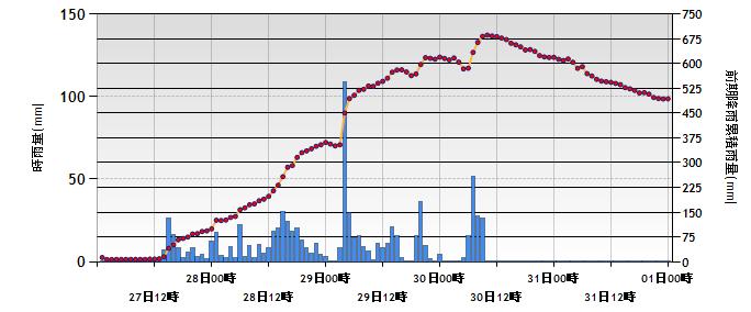 The bar graph is the hourly precipitation, using the left scale. The dots are I think a measure of effective rainfall, but I am unsure as to how this was calculated. Note that there was one hour on the 29th August when rainfall exceeded 100 mm (4 inches) in an hour! The first failure occurred shortly after this event. However, the other two failures occurred significantly later, indeed when the main component of the rainfall associated with the typhoon had ceased and even the effective rainfall measure was declining.
These apparently delayed failure events are common in large landslides, reflecting a range of factors including the time taken for the rainfall to raise groundwater level and the time taken for the development of a failure surface. This is a very important consideration in the development of warning systems for landslides.
9 September 2011
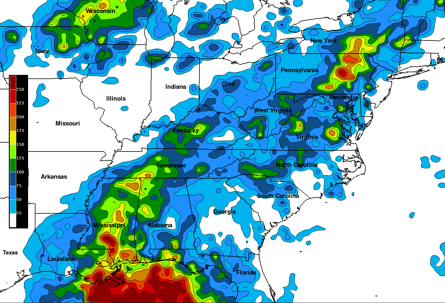
Updated: Rainfall impacts from Irene and Lee
As my fellow AGU blogger Dan Satterfield has pointed out in a post today, heavy rainfall from the former tropical storm Lee across eastern USA is falling on ground that has already been saturated by the passage of tropical storm Irene. The latest storm appears to be generating substantial rainfall totals. This NASA image derived from TRMM data shows rainfall totals for the period 31st August to 8th September:
The upshot is serious flooding and landslide problems. Two substantial ones are being reported at the moment. First, this news report describes what appears to be a rather interesting failure on the banks of Chickamauga Lake in Tennessee:
Half a million dollars worth of property slides straight into Chickamauga Lake, and now the homeowner is describing how it all happened. Ed Cagle lives on Harrison Bay and woke up early Tuesday morning to hear his dock, pool, and backyard slam into the water below. Cagle tells us he had a 65 foot retaining wall installed about 10 years ago. He says it had all the proper draining tubes and reinforcements, but it simply couldn’t withstand the ten inch downpour.
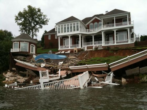
http://www.newschannel9.com/sections/article/gallery/?pic=1&id=1004599&db=wtvc
The homeowner does appear to be right that this is a failure of a sheet pile wall. It is slightly surprising to see it deformed in this way. I wonder how deeply it was founded into the ground:
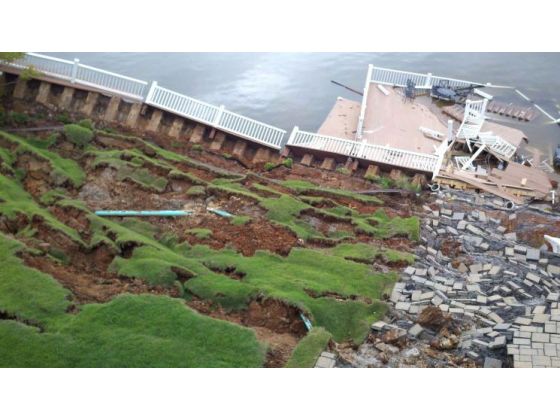
http://www.newschannel9.com/sections/article/gallery/?pic=2&id=1004624&db=wtvc
Meanwhile, across in New Jersey there are reports of a landslide at Liberty Township in Warren County, near to Mountain Lake. According to the news reports, this has occurred on Lewis Lane, which Google Maps indicates is at the following location:
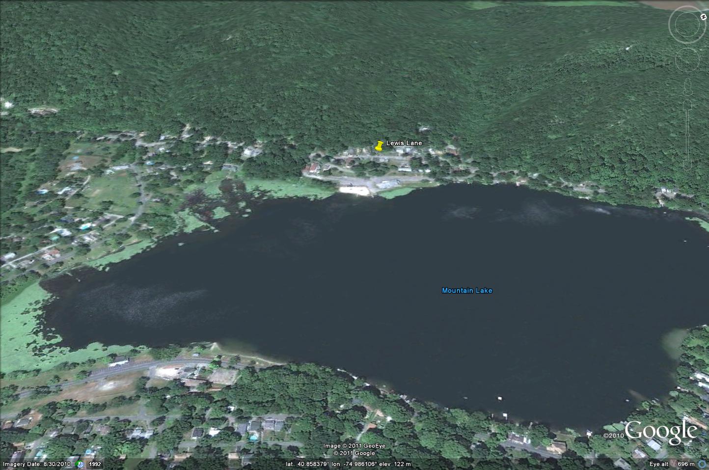
So far one home has been lost, and 50 families habve been evacuated:
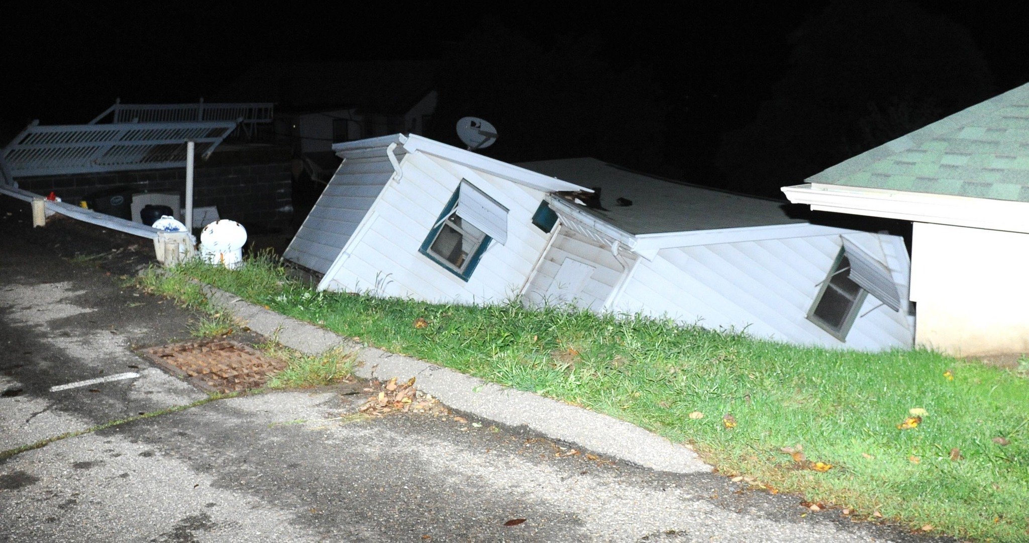
http://media.lehighvalleylive.com/warren-county_impact/photo/mudslide-on-lewis-lane-damages-homes-d9d1ba2bacf4c166.jpg
I wonder what this rainfall will be doing to the Keene Valley landslide in New York as well (see here for details from earlier in the year).
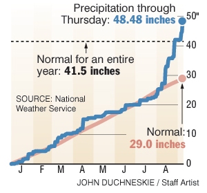
Update: The Philadelphia Inquirer has a really interesting cumulative rainfall graphic for the year to show just how substantial this recent precipitation sequence has been:
 Meanwhile, landslides are wreaking havoc elsewhere:
- Seven people were killed today in Xinjiang in China in a landslide. Interestingly, the report suggests that this might be another mine waste accident.
- Six people were killed, and another is missing, in Uttaradit in northern Thailand.
- Heavy rainfall is expected in the typhoon Talas affected areas of Japan today. This news report warns of the potential for collapse of landslide dams created by the previous event: “The land ministry’s regional branch warned Thursday that dams created by landslides in Gojo, Nara Prefecture, and Tanabe, Wakayama Prefecture — which are believed to have filled up with muddy rainwater — could be breached as early as Thursday night, possibly causing serious flooding downstream. Concerned about the possible breach of such a dam upstream, the village of Totsukawa in Nara Prefecture instructed around 300 villagers in about 160 households to evacuate. In Gojo, around 70 people in 40 households were ordered to evacuate, while in Tanabe 30 people in 19 households were ordered to do so.”
8 September 2011
Videos of a large rockfall near to Christchurch
An interesting video of a deliberate rockfall in the Sumner area near to Christchurch has been posted on this website. Unfortunately I cannot embed it, but this screenshot provides a general idea of what it is like:

This was the result of a block being detached by work crews seeking to remove loose material generated by the earthquake sequence earlier this year.
Rockfalls during clearance works at the same site are also shown in this video:
http://www.youtube.com/watch?v=h_tZjT850qI
The best section occurs between about 50 seconds and 1 minute 10 seconds.
7 September 2011
Landslides in Japan from typhoon Talas
Thanks to Colin Stark of Columbia University for his help in tracking down information about these landslides.
The impact of typhoon Talas in Japan is now slowly becoming clear. A press statement by the Chief Cabinet Secretary on Monday indicated that 25 people had been killed and a further 52 people were still missing, with 89 people have received injuries. However, press reports in Japan suggest that the actual figures may be higher, with 38 people having been killed and 56 people remaining missing. Heavy rainfall continues to fall across parts of Japan.
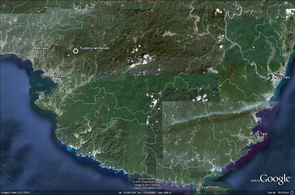
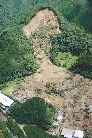
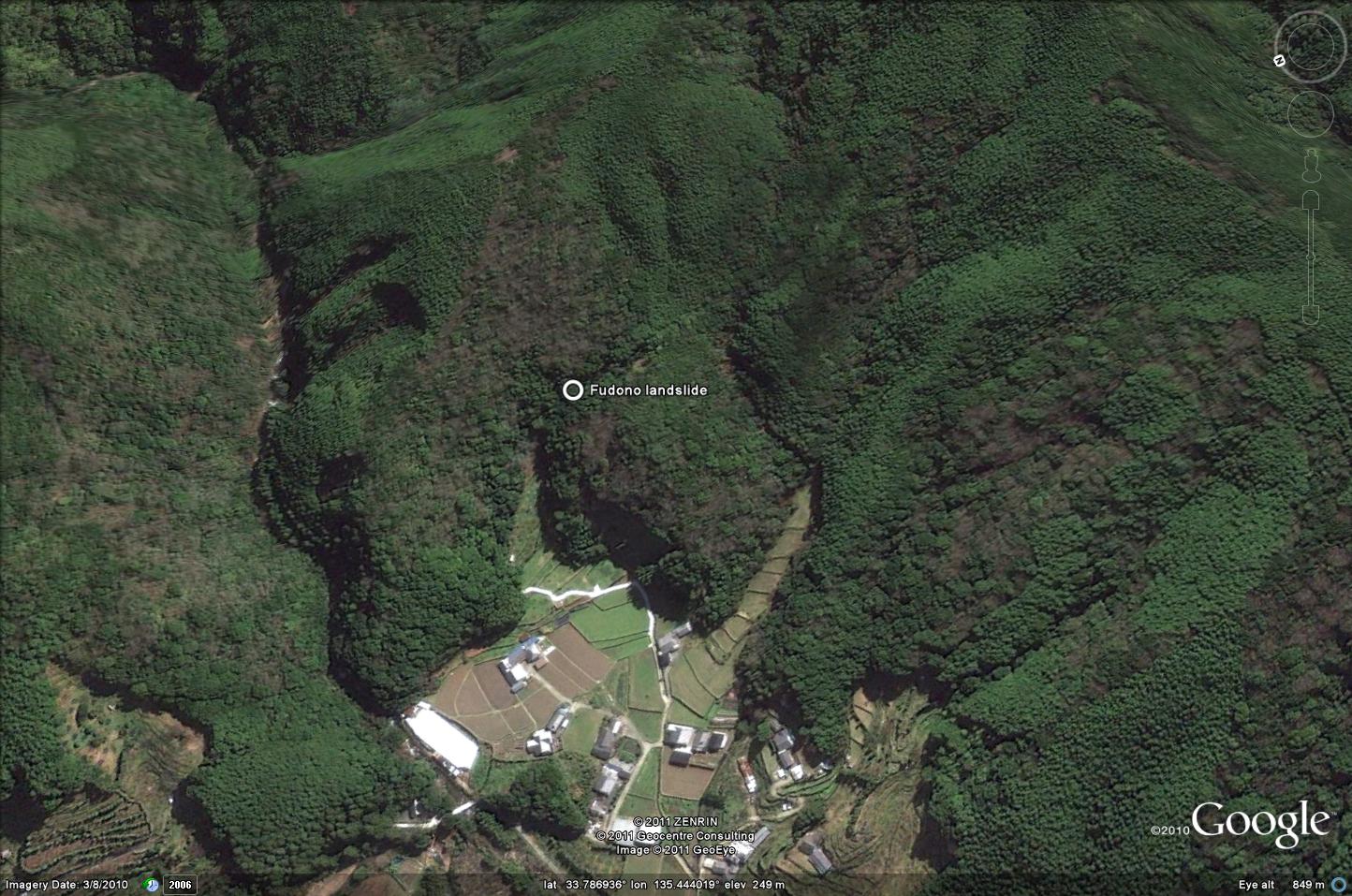
The area that appears to have been particularly bad affected is Fudono village in Wakayama. The Google Earth image below shows the location of one landslide, at Fudono, which is reported to have killed five people:
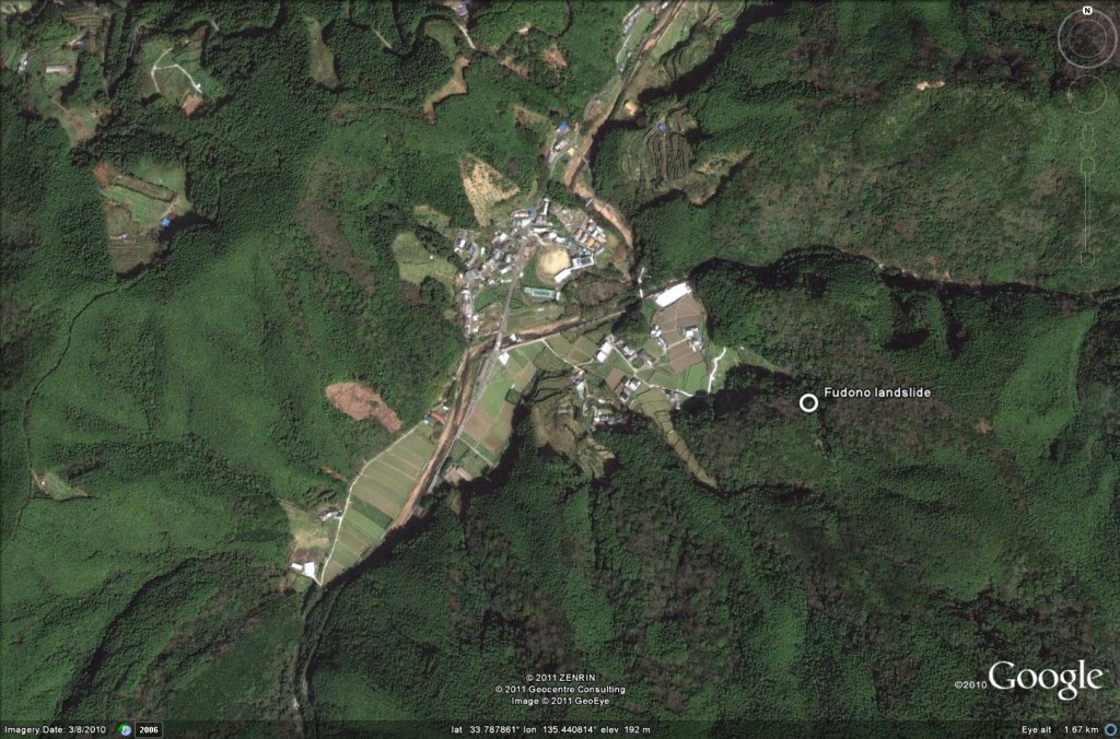
The actual landslide location in detail is shown here:
This news report carries a good image of the landslide (shwon below, which is also civered in a video that can be viewed here:
By way of comparison, this is the Google Earth perspective view of the site before the landslide:
The news report from which the image above also notes a deep-seated landslide at Gojo in Nara Prefecture. I am unsure as to whether this is the valley-blocking landslide that is shown in this images in this news report (in Japanese):
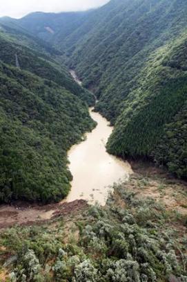
This video (which plays very slowly) has footage of both the landslide shown above and another one that may have blocked the valley temporarily:
5 September 2011
Without doubt the most amazing landslide of the year so far – Pingtung County, Taiwan
Hat-tip to Chingying Tsou of Kyoto University for the heads up for this, and to the Soil and Water Conservation Bureau in Taiwan, who have provided the information. They are putting together a report on this landslide, so I will leave the detail to them, but this is a small taster of what is to come.
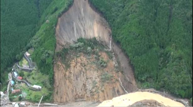
During the passage of typhoon Nanmadol across Taiwan last week, a large landslide was triggered at Manchou in Pingtung County. This map Google Earth perspective view shows the location of the landslide:
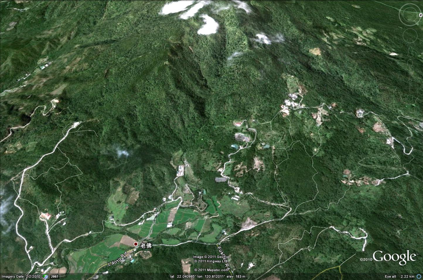
The coordinates are: Lat 22.038, long 120.803 if you want to look this up. The mass movement, which is being called the Laufoshan Landslide, failed twice (on 29th and 31st August), with a reported runout distance of 6 km (corrected, but this is unverified at the moment). Fortunately no-one was killed.
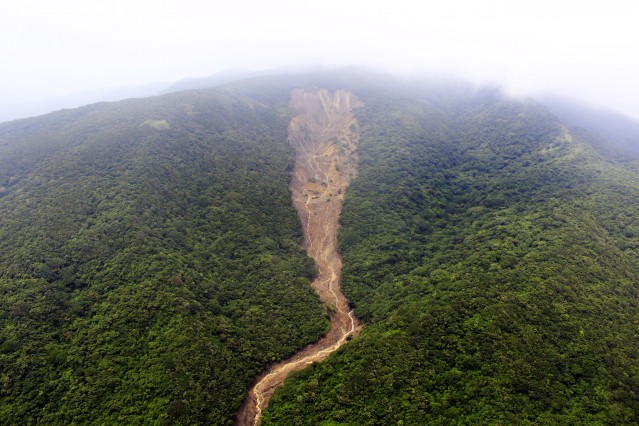
This is the source area of this remarkable landslide:
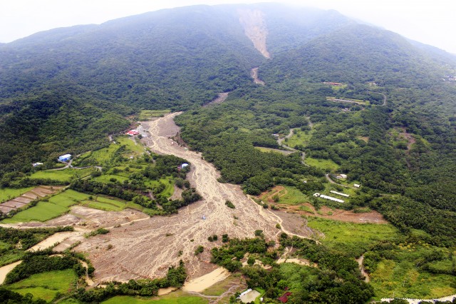
And this is the landslide track:
I will post a link to the Soil and Water Conservation Bureau information about this landslide as soon as it becomes available.
4 September 2011
Landslides and floods from Typhoon Talas in Japan
Late last week I noted that the rain-induced impact of tropical cyclones can be enhanced if they move slowly. Right on cue, typhoon Talas has illustrated the point as it made landfall in southern Japan. The Google Earth map below shows the track data (from here) for the typhoon as it made landfall in Japan:
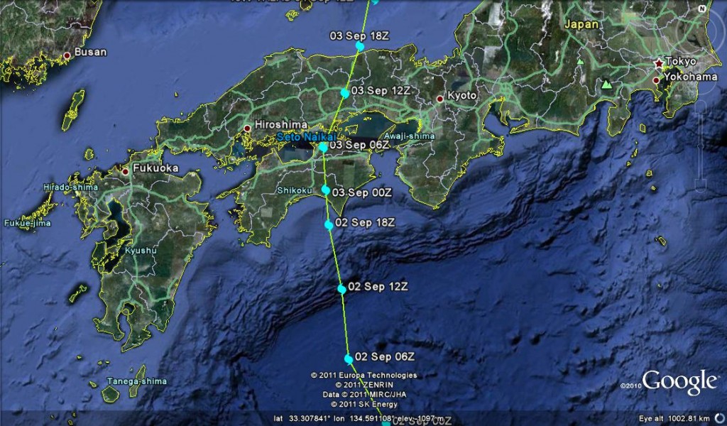
The dots show the location of the storm centre (the eye when fully formed) every six hours. Note how the dots bunch as the storm makes landfall – the slowing is a recipe for very large rainfall totals. Sure enough, the upshot has been very serious for this part of Japan, with 20 people reported to have been killed and up to 50 more missing. The authorities have warned that this toll might well rise as more landslides and floods are a distinct possibility. The picture remains quite confused at the moment, but hopefully will become clearer in the next 12 hours. Reports do suggest that the rainfall totals have been exceptional, approaching 600 mm on Sunday alone and exceeding 1800 mm in a week in some areas. TRMM satellite data for the last week picks up the track of the storm through areas of intense rainfall in Japan quite well (warm colours = high rainfall totals;image from 12:00 UTC on 4th September):
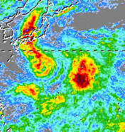
It is clear that at least some of the losses are from landslides, but we need to wait for more information to see how great the impacts are in reality.
1 September 2011
Reflections on Hurricane Irene – it’s as much to do with water as wind
There is a widely held perception that the impact of tropical cyclones (i.e. hurricanes and typhoons) is primarily associated with wind damage. Indeed, the standard way of categorising the strength of a tropical cyclone is the Saffir-Simpson scale, which is essentially a measure of peak sustained wind speed. There is no doubt that wind is an exceptionally damaging component of tropical cyclone impacts, and that it also plays a key role in determining the magnitude of a storm surge. However, take a look at this gallery of before and after images of the impact of Hurricane Irene (and I should add that this is not a website that I would recommend browsing more widely…). The most striking thing is that the images show the impact of water, not wind. Indeed, for most tropical cyclones it is water that does the damage – whether it is in the form of a storm surge, river floods or landslides. This focus on wind is in my view a dangerous misconception about tropical cyclones.
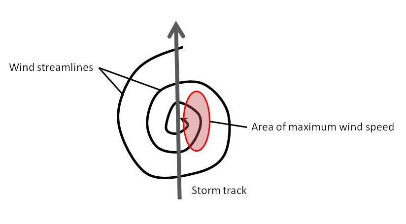
Let me give an example. For wind speed, the greatest impacts are likely to come where a very strong tropical cyclone is moving quickly. This simple diagram illustrates how the forward track of the tropical cyclone and the circulating winds serve to increase the impact of the storm:
 However, for damage associated with rainfall, exactly the opposite is the case. If the storm moves quickly, then the area of most intense precipitation passes rapidly over a given spot, and the damage is more limited. The real problems with rainfall often occur when the storm effectively stalls (i.e. stops), allowing really intense rainfall over a long period. And tropical cyclone precipitation is extraordinary. This graph, from Shieh et al. (2010), shows hourly and cumulative rainfall from the 2009 Typhoon Morakot in Taiwan:
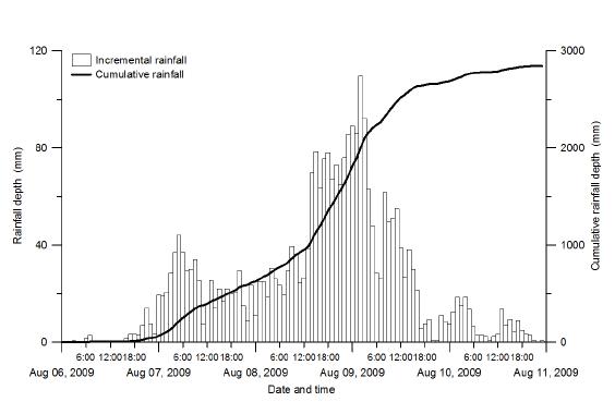 Note that the peak rainfall intensities are in excess of 100 mm per hour, and the total rainfall from this single storm exceeded 2700 mm. Unsurprisingly, the impacts were catastrophic. Unfortunately, the lack of understanding of the rainfall impacts of tropical cyclones leads to a lack of preparation at both an individual and a societal level, and a sense of surprise when rainfall-induced disasters occur.
So, there seems to me to be an urgent need to do two things. The first is to improve understanding of the range of impacts associated with tropical cyclones, and in particular with respect to rainfall induced disasters. Second, it really is time that we improved the Saffir-Simpson scale to encompass more than wind speed, such that the potential impacts of an impending tropical cyclone can be properly assessed. This is clearly not a trivial task, but it would seem to be an urgent research need.
Reference
Shieh, C-L. et al. 2010. An overview of disasters resulted from typhoon morakot in Taiwan. Journal of Disaster ResearchVol.5, No.3, 236-244.
 Dave Petley is the Vice-Chancellor of the University of Hull in the United Kingdom. His blog provides commentary and analysis of landslide events occurring worldwide, including the landslides themselves, latest research, and conferences and meetings.
Recent Comments