
16 September 2011
Catching up part 1: The landslide at Pingtung in Taiwan
Posted by Dave Petley
having spent the last week essentially out of contact in Torridon in the Highlands of Scotland, I am going to try to catch up again over the next few days. There has been a great deal going on in my absence! So, to start off, a brief update on the Pingtung landslide in Taiwan that I featured last week. Thanks to Ching-Ying Tsou for pointing out that the Soil and Water Conservation in Taiwan now have a poster online about the event at this location. The key information seems to be that the landslide occurred in three stages, first at 7 am on 29th August, then at 6 pm on the 30th and again at 3pm on the 31st. Perhaps the most interesting element is the graph showing the rainfall record for the site:
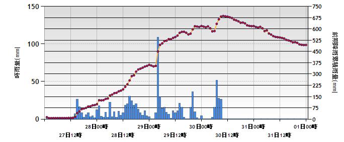 The bar graph is the hourly precipitation, using the left scale. The dots are I think a measure of effective rainfall, but I am unsure as to how this was calculated. Note that there was one hour on the 29th August when rainfall exceeded 100 mm (4 inches) in an hour! The first failure occurred shortly after this event. However, the other two failures occurred significantly later, indeed when the main component of the rainfall associated with the typhoon had ceased and even the effective rainfall measure was declining.
These apparently delayed failure events are common in large landslides, reflecting a range of factors including the time taken for the rainfall to raise groundwater level and the time taken for the development of a failure surface. This is a very important consideration in the development of warning systems for landslides.
 Dave Petley is the Vice-Chancellor of the University of Hull in the United Kingdom. His blog provides commentary and analysis of landslide events occurring worldwide, including the landslides themselves, latest research, and conferences and meetings.
thank very interesting
Dave, just should be 100mm …
[…] is the second catchup post (the first is here) after my recent travels. Thanks for the patience of everyone who sent me […]