
31 August 2011
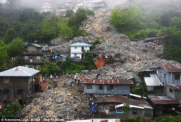
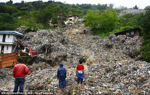
Garbage dump landslide in the Philippines
The Daily Mail has an online article this morning with a set of images of the garbage dump landslide that was triggered by Typhoon Nanmadol at the Irisan dumpsite in the city of Baguio in the Philippines earlier this week. The garbage reportedly buried at least 20 houses. Three bodies of children have been recovered; two further victims are believed to be buried in the waste.
http://www.dailymail.co.uk/news/article-2032012/Garbage-landslide-Five-people-missing-rubbish-floods-city-dump-site-walls-collapse-Typhoon-Nanmadol.html?ito=feeds-newsxml
http://www.dailymail.co.uk/news/article-2032012/Garbage-landslide-Five-people-missing-rubbish-floods-city-dump-site-walls-collapse-Typhoon-Nanmadol.html?ito=feeds-newsxml
The cause of the landslide appears to be the collapse of a retaining wall.
Back in 2008 I posted a review of garbage dump landslide incidents – this is still available here. Garbage dump landslides remain a serious problem in less developed countries, but at the moment they are poorly understood.
30 August 2011
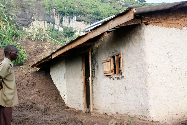
Serious landslides in Uganda
http://allafrica.com/stories/201003090657.html
Whilst attention has been focused on the effects of Hurricane Irene and Tropical Storm Nanmadol (which is currently making landfall in China), a substantial landslide disaster in Uganda yesterday has been scarcely reported. Heavy rainfall affected the slopes on Mount Elgon, a large volcano located on the border between Kenya and Uganda. This is an area that was heavily affected by landslides on 1st March last year, resulting in 358 fatalities (see a description of this event, with images, here). There is some confusion about the magnitude of loss of life in the most recent event. The Ugandan newspaper the Daily Monitor reports that 43 people may have been killed in two landslides, although other estimates in the same article suggest lower totals. New Vision reports that 36 bodies have been recovered to date.
Meanwhile, Xinhua has an illustrated account that indicates that the total may exceed 50 people. The main location of the landslides appears to be Sisiyi and Buluganya sub- counties in eastern Bulambuli District. Unfortunately, further heavy rainfall is forecast in the area.
The causes of this sequence of landslides are not entirely clear, but deforestation and rapid population growth in an area of fragile volcanic soils may well be significant factors.
24 August 2011
New satellite images of the Attabad landslide site
The NASA Earth Observatory, via the EO-1 satellite team, have kindly collected a new image of the Attabad dam site in northern Pakistan, and have made the images available. In the last few weeks there has been little solid information about the state of the dam, although in Pakistan the violent response by the authorities to a demonstration by displaced people, which resulted in the deaths of two men, has been a major news story.
This new image was collected early this month (3rd August) using the EO-1 satellite. The data have been processed into two products – a true colour composite (which resembles an aerial photograph):

And second a SWIR image, which highlights the difference between land and water:
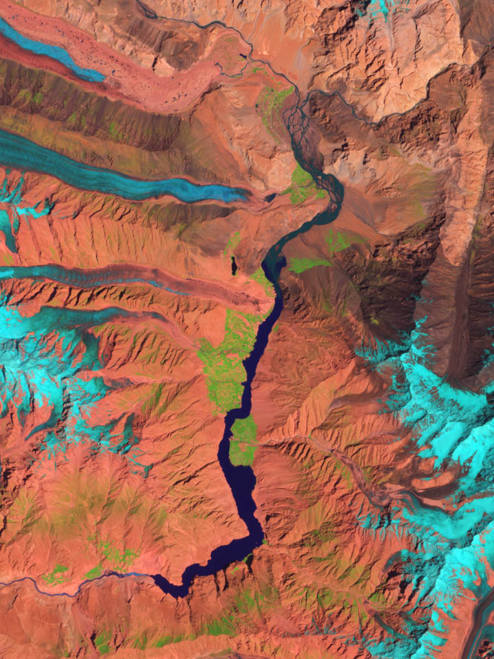
Of course the most interesting aspect is the evolution of the spillway. The image below shows this area on the TCC image:
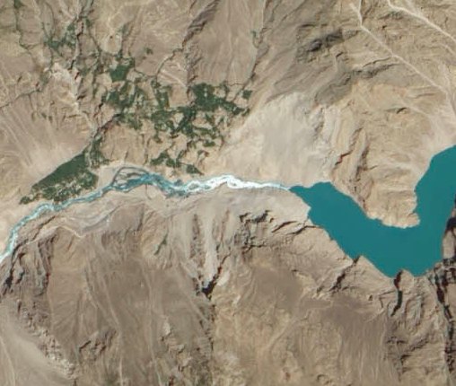
Compare this with an image collected by the same instrument in early June:
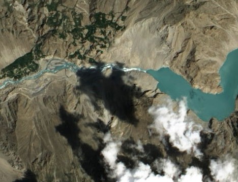
There is noticeably more flow through the spillway than in the earlier image, and there appears to have been some downstream erosion through widening of the channel. However the flow is still being controlled by the narrow section at the dam crest, which appears to have undergone little change.
Summer is now almost over in this part of northern Pakistan, such that flows will start to reduce again in the next few months. It will be interesting to see whether the government uses this coming winter to reduce the height of the dam.
17 August 2011
Hong Kong Slope Safety – two videos reconstructing the 1972 and 1976 landslides
The Geotechnical Engineering Office (GEO) in Hong Kong have released via Youtube two videos reconstructing the devastating landslides of 1972 and 1976. These events were the trigger for the formation of GEO, and the initiation of the most successful landslide management programme in history. The first reconstructs and simulates the Po Shan Road landslide:
The second looks at the 1972 and 1976 landslides in Sau Mau Ping:
http://www.youtube.com/watch?v=IvDqDmyyaHc
These are quite excellent resources (although for some reason the second one kept freezing for me at the four minute point – I hope this is due to my internet connection in Switzerland).
9 August 2011
Two new landslide videos – including an amazing pulsing debris flow
Another two landslide videos have popped up – and both are fascinating. First, former Durham student Georgie Bennett captured this multi-stage landslide near to Merano in Italy on 2nd August:
Fortunately no-one was killed. Note the weather – fine and sunny – so no obvious trigger.
Second, the Pamir Times has today posted this video of a very large debris flow in Talis village, Ghangche District, in the Baltistan region of northern Pakistan. The Youtube page notes that “At least 60 houses were destroyed by the debris flow disaster that hit Talis village of Ghangche District, in Baltistan region. Last year a similar flood had taken the lives of 13 people at Talis. Around 120 families of Talis have been evacuated to safe areas, where they are living in tents.”
Do watch this one carefully as it captures beautifully the pulses or waves of movement through the mass, with periods of essentially no movement (actually probably creep) between them. The different sizes of the pulse mean that each movement event is different in terms of the amount of material mobilised (sometimes material right up to the banks moves, at other times just the material in the centre of the channel), the velocity and the duration. You will note also that the surface rises as the front of the pulse comes through. Once you get your eye in, this is quite fascinating and surreal to watch.
Comments and thoughts welcome please!
8 August 2011
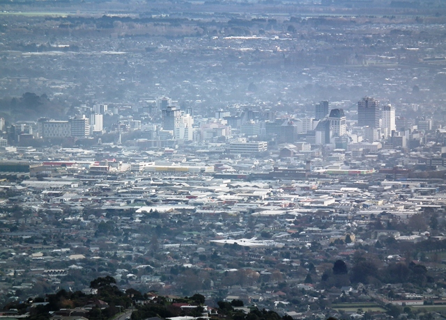
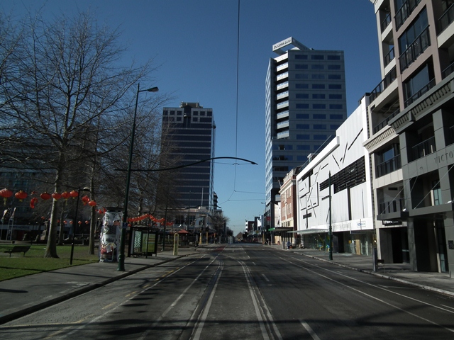
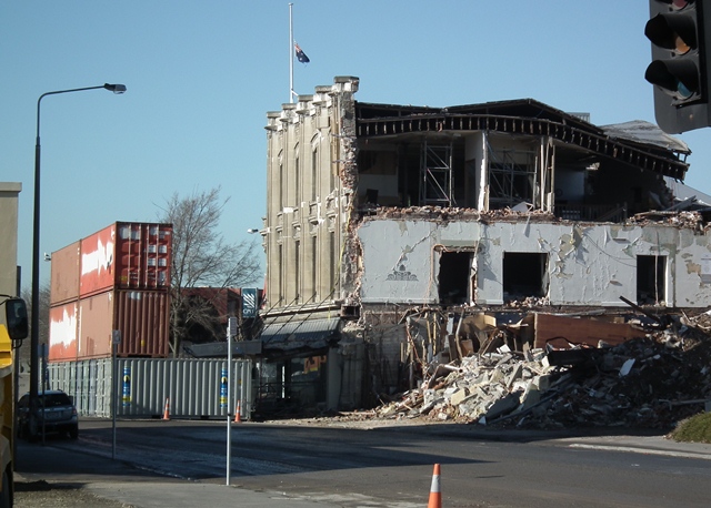
Pictures of the earthquake-devastated city centre of Christchurch, New Zealand
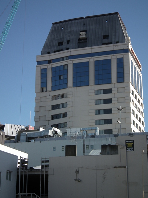
Last week I was lucky enough to be able to spend a few hours in the “Red Zone”, the closed off city centre of Christchurch, New Zealand. The number of unstable buildings means that this area is still too dangerous to reopen, and there remains a great deal of demolition to do. From a distance, this is what the city centre looks like now:
If you look very carefully, you can see the lean on the Grand Chancellor hotel (centre right of the image). This building came very close to collapse, and is now being slowly dismantled. From close up the reasons are clear:
There are other large buildings that are also profoundly damaged, although often the issues are less clear. These two buildings are both leaning (in both cases towards the road). Note also the deserted streets – it is a very eerie place in which to spend time:
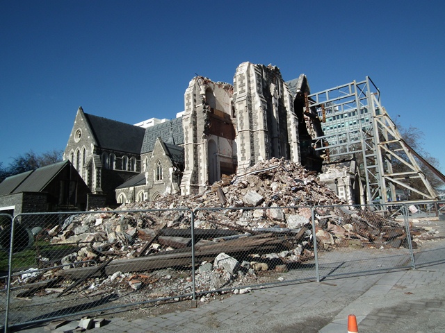
The iconic profoundly damaged building is of course the cathedral. It is hard to see how it can be recovered without an almost complete rebuild – note the huge steel buttress propping up the gable end:
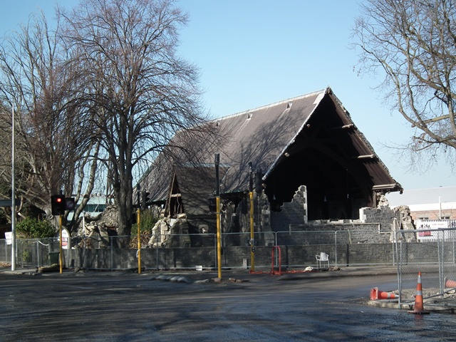
Indeed, throughout the city churches performed extremely poorly during the shaking. This is another example just on the edge of the Central Business District:
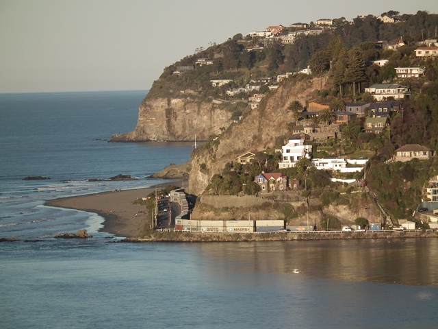
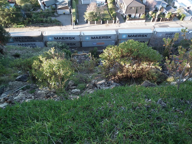
In some cases it is not immediately obvious why buildings are dangerous. This pile of shipping containers, located to protect road users in case the building behind collapses, appears initially to be superfluous:
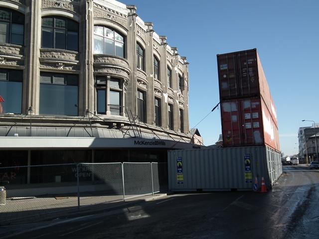
However, when seen from the opposite direction, the reasons are very clear:
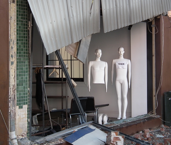
Finally, this rather surreal sight of a shattered shop rather summed up the state of the city centre for me. Recovery will take a long time:
6 August 2011
Landslides from the Christchurch earthquakes part 5: landslides that involve sliding
The other posts in this series are as follows:
Part one: boulder damage to a house
Part three: topographic amplification at the cliff tops
Part four: large-scale cliff collapses
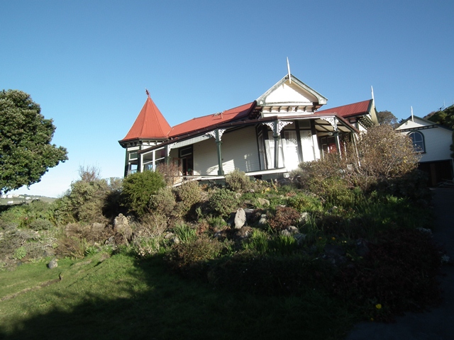
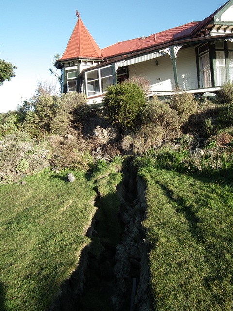
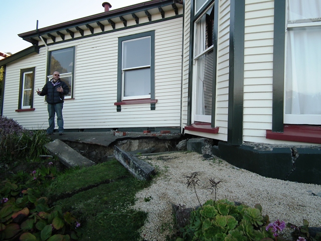
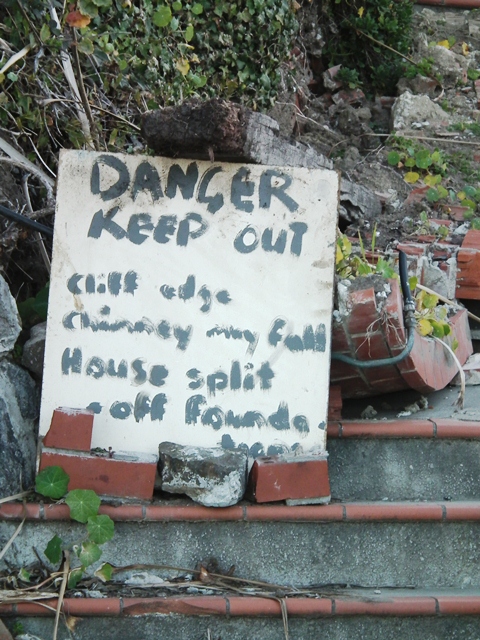
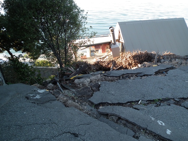
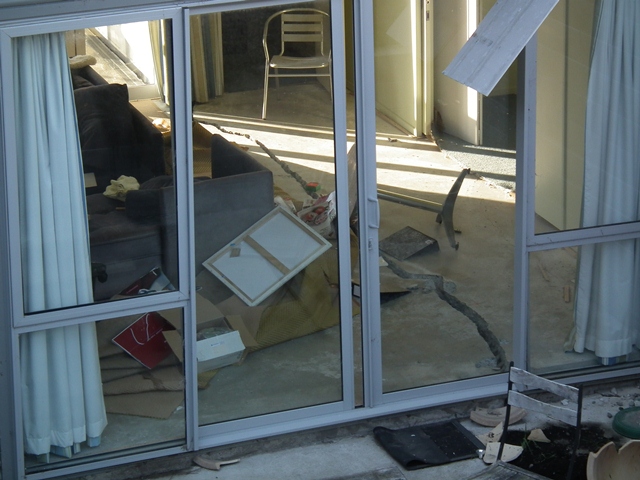
There were a small number of landslides with sliding associated with the earthquake, mostly in the hills to the south and east of Christchurch. This post includes images from two of these slides. Both are poorly understood at the moment but have caused substantial levels of damage. In both cases, substantial tension cracks have opened up at the rear of the slide, with very serious implications for the buildings in that area. From a structural perspective, this is probably the most heart-breaking site that we visited. This beautiful, old clifftop home has the tension crack from a translational slide running straight through the front of the house:
Look carefully at the structure and the roofline and you can see the damage that is being caused by the landslide. The tension crack is now up to about a metre wide. There seems little hope to me that the structure can be saved:
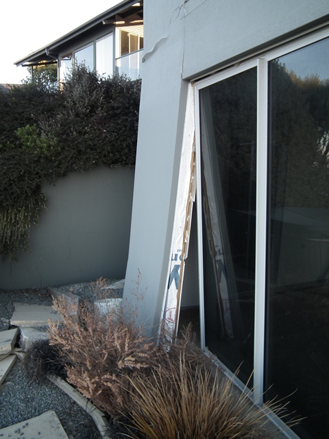
The tension crack exits on the other side of the house, undermining the foundation:
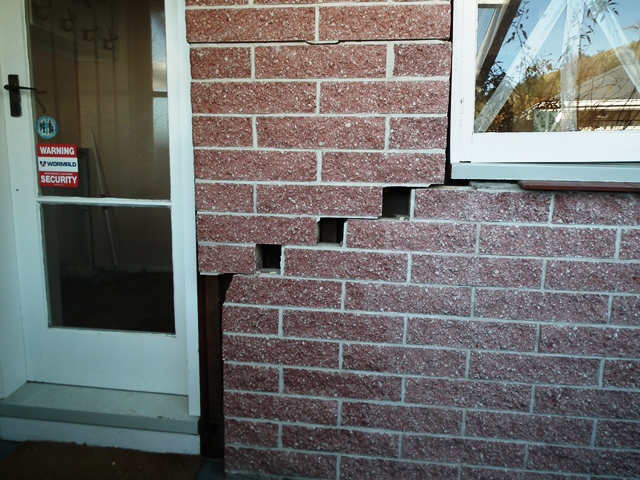
Elsewhere, brick structures also showed the effects of the development of tension cracks:
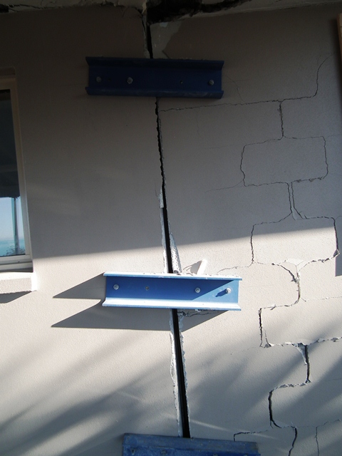
In some cases, desperate measures have been employed to try to prevent buildings from being pulled apart:
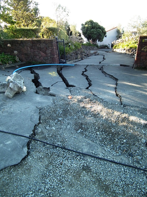
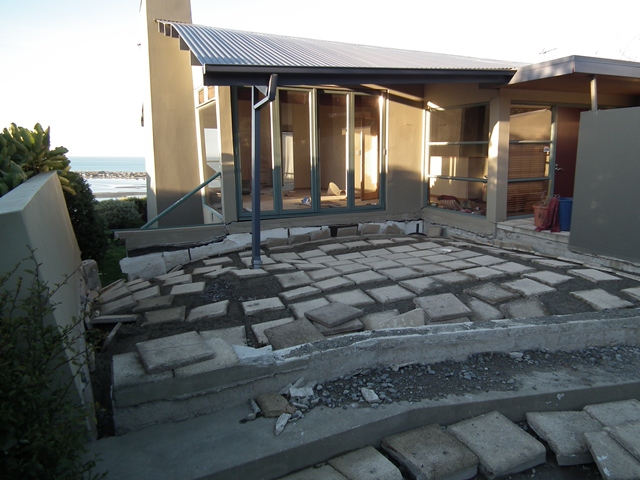
The landsliding is also having a major impact on the roads in the affected areas. This is an area of extensional cracking close to the house shown in the first image:
In one of the landslides, the movement is also toeing out in an area of houses. In this case, the buildings are affected by compression. This fence line has been buckled by these compressive forces:

It is really important to remember the human cost of these landslides, which is very high. In some cases, despite their losses, home owners have been very thoughtful about the risks to others:
In other cases, there are some very sad appeals to the authorities:

The other posts in this series are as follows:
Part one: boulder damage to a house
Part three: topographic amplification at the cliff tops
Part four: large-scale cliff collapses
5 August 2011
Landslides from the Christchurch earthquakes part 4: large-scale cliff collapses
The other parts of this series may be found here:
Part one: boulder damage to a house
Part three: topographic amplification at the cliff tops
Part four: large-scale cliff collapses
Part five: landslides that involve sliding
In the Christchurch earthquakes there were a number of large-scale rock collapses in the areas to the south-east of the city. These events caused a small number of fatalities and considerable damage. At the lower end of the scale were some isolated rock detachments, albeit involving large blocks:
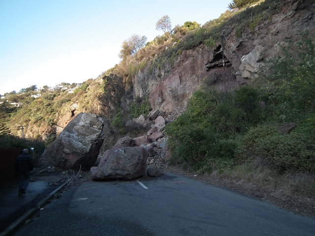
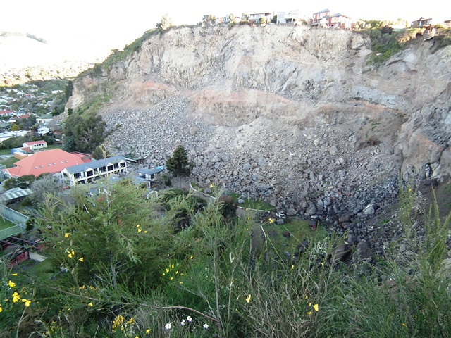
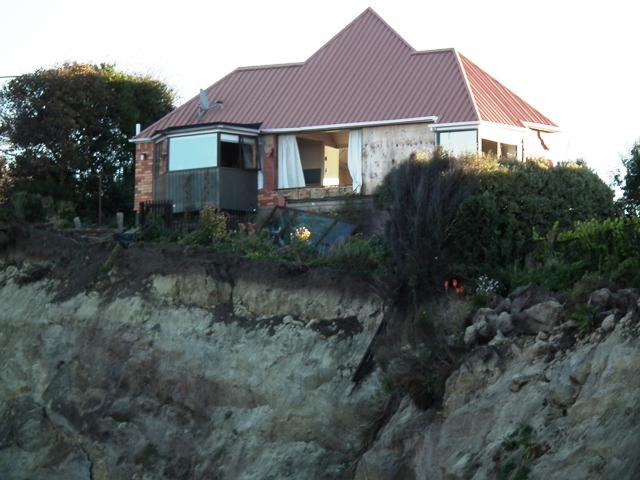
However, the real story is with some very large cliff collapses that have driven retreat of the clifftop by ten metres or more. These two image show two of these very large collapse sites. Note the inundation of the land at the toe of the slopes and the proximity of some buildings to the debris:
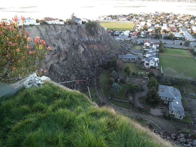
The impacts on properties at the top of the cliff has been severe. In some cases, houses have already been partially or completely destroyed as a result of the rockfalls:
In others, blocks that have partially detached, but not yet failed, have opened huge cracks that have profoundly damaged properties. In some cases these blocks extend tens of metres back from the clifftop, leaving a long-term legacy of severe hazard. This house for example has one of these cracks extending through the living room:
This house is also on one such block. The lower part of the house is being pulled apart as it moves:
Meanwhile, this house is entirely on such a block, such that the deformation is occurring in the patio on the road side of the building as the structure is being pulled forwards:
Finally, these cracks of course mean that there is a huge volume if potentially unstable material that threatens roads and buildings at the toe of the slope. As an emergency measure, shipping containers are being used to provide protection:
The next part of this series should follow tomorrow. It will look at conventional landslides triggered by the earthquake. On Monday I will post some images of the ruined city centre.
The other posts in this series are as follows:
Part one: boulder damage to a house
Part three: topographic amplification at the cliff tops
Part four: large-scale cliff collapses
Part five: landslides that involve sliding
4 August 2011
Two important ongoing tropical cyclone hazards
Tropical cyclone activity finally appears to be recovering, and there are now four developed systems in operation across the globe. Two of these are the potential cause for concern. The larger is typhoon Muifa, which is out in the NW Pacific Ocean. However, its forecast track has it strengthening and grazing the coast of eastern China over the next few days:
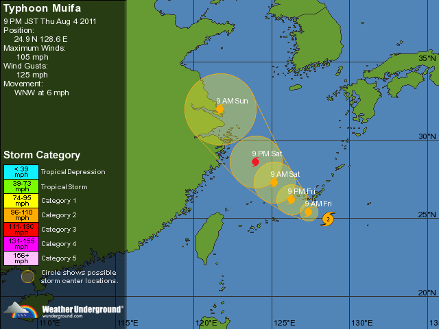
Current forecasts are that it will pass very close to Shanghai,and concern is already being expressed that the impacts could be substantial. Its track thereafter is hard to predict, but it has the potential to bring heavy rainfall across a wide area.
On the other side of the world, Tropical Storm Emily is just crossing Haiti, which remains very vulnerable in the aftermath of the earthquake last year:
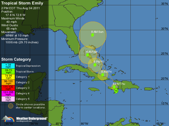
Although only a small storm by tropical cyclone standards, it has the potential to bring very heavy rainfall. Once again the outcomes are unpredictable. It remains very fortunate that Haiti has to date avoided a direct hit from a full strength Hurricane.
Images of landslides from the Christchurch earthquakes part 3: topographic amplification at the cliff tops
This is part 3 of this series. The other posts in this series are as follows:
Part one: boulder damage to a house
Part three: topographic amplification at the cliff tops
Part four: large-scale cliff collapses
Part five: landslides that involve sliding
One of the key aspects of landslide and rockfall triggering in earthquakes is the process that we term topographic amplification. The idea is simple, which is that the topography causes enhanced shaking at key locations. We believe that this is particularly significant at ridge tops and breaks of slope (locations in which the slope gradient changes). In effect it is a resonance effect that causes the ground to shake much more violently in those locations. We think that this is a key process in the triggering of landslides and rockfalls in earthquakes.
Of course it is also potentially bad news for any structures located at the top of slopes too, so I was interested to see how the houses that had occupied those beautiful cliff top locations in the hills to the east of Christchurch had performed. as the pictures below show, the answer is that they did not do well. It is important to stress that these images show shaking damage, not landslide problems (though there is some of that on the ridge tops too – see the post tomorrow…).
The best illustration of the magnitude of the shaking on the ridge tops was found on this balcony:
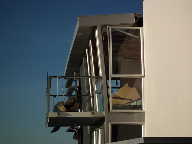
If you look carefully you can see that the plant plot has been smashed. It has clearly been lifted vertically and then dropped, which suggests vertical accelerations considerably in excess of 1 g:

There was huge disruption to even sturdy structures in this area, but similar houses set back from the cliff remained intact. The tile roof of this houses suggests high levels of acceleration:

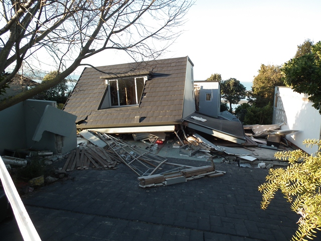
Note the cliff collapses. One or two houses collapsed completely:
Whilst others suffered very signficant levels of damage:
The next post will look at what this meant for the cliffs below. The other posts in this series are as follows:
Part one: boulder damage to a house
Part three: topographic amplification at the cliff tops
Part four: large-scale cliff collapses
Part five: landslides that involve sliding
 Dave Petley is the Vice-Chancellor of the University of Hull in the United Kingdom. His blog provides commentary and analysis of landslide events occurring worldwide, including the landslides themselves, latest research, and conferences and meetings.
Recent Comments