

19 February 2013
More images of the Hatfield Stainforth coal mine landslide
Over the last few days a number of people have very kindly provided images of aspects of the Hatfield Stainforth coal mine landslide near to Doncaster in northern England. Before we get into that, a few people have asked about the nature of the mine – in this case the mine is an underground pit, with the coal and spoil being hoisted to the surface. The landslide has occurred on a heap of spoil from the mine workings.
So, on to the images. Let’s start with a couple of the site before the landslide occurred. Darren Hedges has provided this image of the site before the landslide – this was taken in September 2012, so probably represents the site in its pre-landslide state rather well:
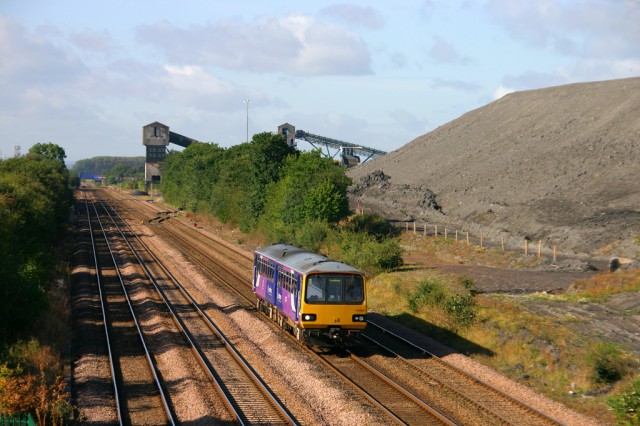 .
.
A friend has very kindly provided these two images of the spoil heap. This one was taken in seven or so years ago from the top of the spoil looking down to the railway line, giving an impression of the site and the landfill beyond:
 .
.
This image was taken on the tip looking towards the pit head, which gives an impression of the height and the slope angles involved:
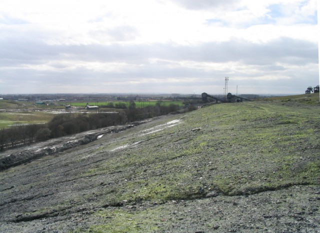
Tim Prosser kindly took a couple of images of the landslide itself on Friday, which provide a benchmark for what has happened at the site since. This is a site overview, with the deformed tip on the right and side and the displaced railway lines on the left:
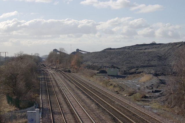 .
.
Zooming in, this is toe of the landslide:
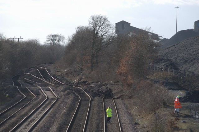 .
.
Chris Street then visited the site at lunch time on Saturday. He collected this image from almost exactly the same point as Tim and Louise: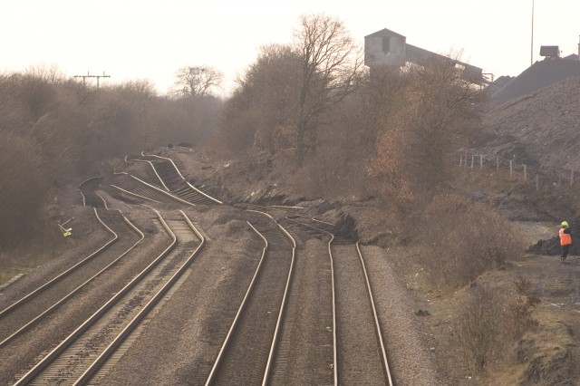 .
.
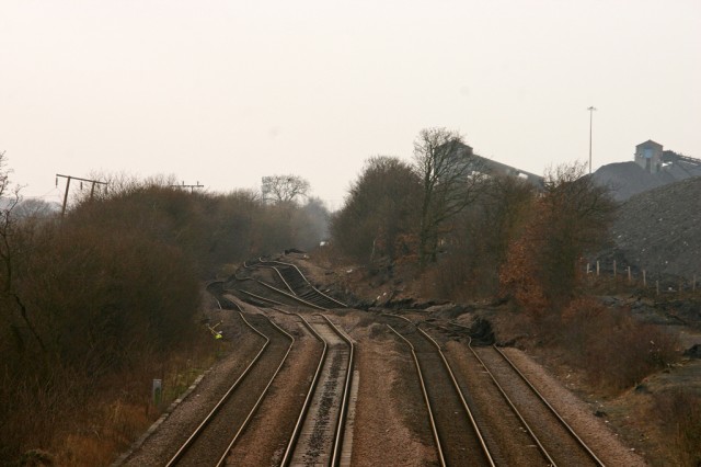
The images are almost uncannily similar. The most important point though is that there is very little change in the intervening 24 hours, suggesting that this part of the landslide had almost stopped moving. Darren Hedges has also provided this image of the site as of yesterday (Monday), from a very slightly different perspective:
 .
.
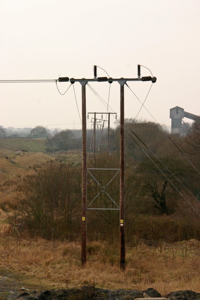
Again, there is no obvious change, suggesting that this portion of the landslide had not moved substantially over the last four days. You will see from the above image that the landslide has affected one of the pylons, which I highlighted as a risk in my post on Friday. Darren has also provided this image of the deformed pylon and the frontal zone of the landslide toe:
Of course this does not give an indication of what is happening at the top of the slope, but unfortunately no further aerial images have been released as far as I am aware. I suspect that the dry weather that we are currently enjoying will be helping with the management of the site – long may that continue.
15 February 2013
New aerial photos of the Hatfield Stainforth colliery landslide
More information is now emerging about the Hatfield Stainforth landslide colliery landslide near to Doncaster in England. First, to help understand the timescale of the development of the site, this image has been provided by Richard Aspinall, a resident of the Stanforth area, before the spoil heap was developed:
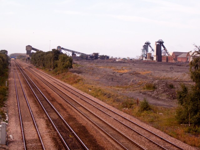
Image copyright of Richard Aspinall. For educational and not for profit use only
The image was taken some years ago and shows that there was no slope present before the tip was created.
Meanwhile, it appears that Network Rail have been distributing a set of aerial images of the landslide, taken (I think) yesterday. Three of these are on the Railway Eye blog, and I reproduce them here with credit to them:
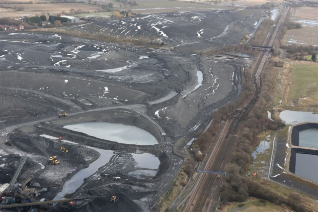
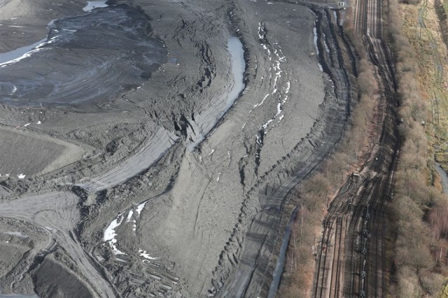
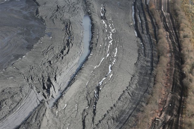 .
.
So what can we say about the landslide from this? Well, first the landslide has continued to develop and displace. The track has now moved considerably further, and indeed the deformation has extended into the field on the far side of the track (where there appears to be a power pylon).
A comparison of the latest images (bottom) with the earlier aerial image (top) is also really helpful:
 .
.
It seems to me that the deformation at the toe now has a large horizontal component of movement, which probably reflects the weak nature of the materials involved. Thus, the landslide is not purely rotational as I suggested yesterday, but may well have a reasonably horizontal surface running through the alluvium. Similarly, the portion of the landslide near to the crown has also deformed plastically. Note that the rear tension cracks have moved towards the slope as well, and a depression has formed ahead of them that has now filled with water. This suggests that the water table may be very high. The material behind the rear tension cracks appears to have flowed towards the slope, which will not be helping with the stability of the system.
The lack of machines on the landslide suggests that the colliery is allowing the slope to stabilise before work starts to manage it. This is the right approach, and will be helped by the dry weather today.
Finally, the magnitude of the task facing those trying to manage the landslide should be clear. Removing the driving load from the top of the slope is far from easy when the material in the tip is deforming into it. Once that load has been removed the bulge at the toe can be excavated (very carefully), and the track can be reinstated. Given how far the track bed has removed, presumably this will be a substantial task.
14 February 2013
The geology and a possible mechanism of the Hatfield Stainforth colliery landslide
Unfortunately, overnight no new images have appeared of the Hatfield Stainforth landslide, so it is difficult to know whether the landslide has now stopped moving. The morphology of the landslide continues to suggest to me that this is a bearing capacity failure. I have taken a quick look at the excellent BGS Geology of Britain Viewer, which produces the following map (I have marked the approximate location of the colliery at which the landslide at occurred):

copyright BGS: http://mapapps.bgs.ac.uk/geologyofbritain/home.html
The map shows that underlying the location of the spoil tip is a layer of alluvium – basically soft sediments such as sands and gravels deposited by ancient rivers. These are comparatively weak materials, especially when wet. So, my hypothesis is that the weight of the spoil tip has caused the development of a failure through these materials, which has then generated a landslide with a rotational geometry. The sketch below is my suggested interpretation, with the spoil sitting over a layer of alluvium. The very wet weather over the last few months has led to a high groundwater level, which in turn has reduced the strength of the alluvium. This has then failed with the geometry shown in the upper sketch – the rotational landslide has then progressively moved to generate the geometry in the bottom sketch:
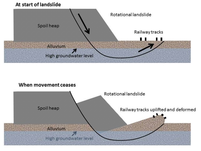
The good news is that this type of landslide is self-stabilising – eventually there is enough material uplifted to balance the load of the spoil, and movement terminates. However, from this it is not difficult to understand from this why it is a challenge to re-establish the railway line. If the uplifted material under the tracks is removed the spoil will not be in balance and the landslide will reactivate. So, to stabilise this slide either the spoil at the back of the displaced block will need to be removed or the strength along the shear surface will need to be increased. Neither are straightforward. Only when that is achieved can the material under the track bed be excavated.
Incidentally, back at the end of November I noted the following in relation to landslides in the UK:
So what next?
The heavy rainfall has now moved away, to be replaced by cold weather, so the immediate threat should start to subside. However, for some slopes the groundwater level will still be rising as the rainfall percolates through, so more landslides are possible. It is notable though that all of the above landslides are shallow – so far there is not much sign of the deep-seated landslide systems reactivating. This is almost certainly because groundwater levels were so low after the prolonged drought that ended in the early summer. These deep groundwater levels will now be rising, so don’t be at all surprised if there are reports of larger landslide movements over the next few months. Places such as Dorset and the Isle of Wight, where there are large coastal landslide systems, will be particularly vulnerable. Such landslides represent a comparatively low level of risk to life, but can cause extensive property damage. It will be an interesting winter.
Thus, it is not really surprising that we are now seeing deep-seated landslides developing. I expect that there will be more over the next two or three months.
13 February 2013
The Hatfield Stainforth colliery landslide – an update suggesting that it has been moving since yesterday
Two new images have become available on Twitter in the last few hours of the Hatfield Stainforth landslide near to Doncaster in NE England. This is a fascinating landslide that is causing a huge amount of damage to the railway lines. First, there is this image taken from further along the line:
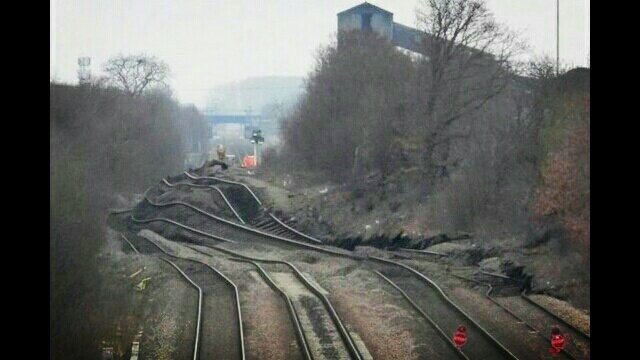
https://twitter.com/Broad_Gauge/status/301679951613153281/photo/1
And second a close up view of the toe bulge shown above:
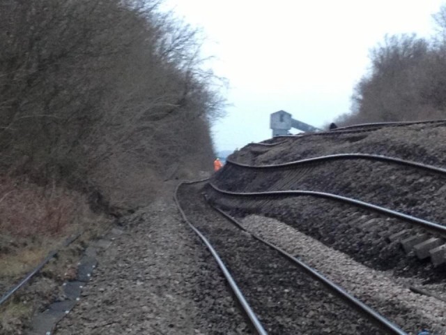
https://twitter.com/sammie_spad/status/301653723187380224/photo/1
If you compare the above with the images of the track taken yesterday you will see that the toe bulge has developed very considerably. Thus, the landslide has clearly moved much further over the last 24 hours. Hopefully a better set of images of the whole landslide will appear in the next few hours, but this continue to suggest to me that this is a rotational slip caused by a bearing capacity failure in the underlying ground, but I must stress that this no more than speculation at this point.
Network Rail are saying that the repairs will take eight weeks after the colliery finish their work. However, the colliery element of this is going to be far from trivial, so I’d imagine that the repairs may take a considerable amount of time. The ground deformation along the track probably cannot be removed until landslide behind is stabilised, and this will probably require that material is removed from the top of the landslide.
An unusual colliery landslide yesterday – Hatfield Stainforth in Northern England
In the UK there is a very high level of sensitivity about colliery landslides because of the Aberfan disaster over 40 years ago. The result has been a huge effort to prevent and mitigate landslides associated with coal mines, such that colliery landslides are now unusual. Thus, the very large landslide at Hatfield Stainforth on the outskirts of Doncaster is very surprising. This may well be the largest and most significant landslide in the UK for a decade or more, even though the mainstream media has yet to catch up with it. You will see what I mean when you see the aerial photograph released by Network Rail via Twitter last night, which says it all:
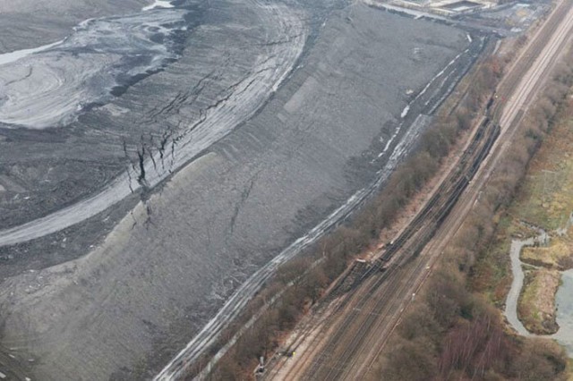
https://twitter.com/networkrail/status/301424568516632576/photo/1
The spoil is from the Hatfield Colliery, which reopened in the last few years. Note at the crown of the landslide the multiple arrays of tension cracks; the lack of lateral scarps (so far…); the toe bulge and the enormous deformation in the railway lines at the toe. Note that this is an active line, which unsurprisingly is now closed. The following Network Rail image shows why:
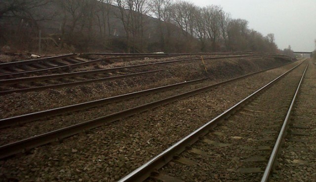
https://twitter.com/networkrail/status/301424568516632576/photo/1
It is hard to know exactly what has happened here, but the size and geometry of the toe bulge might suggest a bearing capacity failure, when the ground supporting the slope fails. In this case the ground has been loaded by the spoil heap,, and my hypothesis would be that a failure surface has developed through it, allowing a quasi-rotational failure to develop. Whatever the cause, managing the slope is going to be very difficult. It will not be possible to simply excavate the material around the railway line as this would remove support from the toe, promoting further movement. It is more likely that material will have to be removed progressively from the crown area, but very carefully.
I would imagine that the deformed lines will be out of action for some considerable period of time and I am sure that work will also be going on to ensure that no other failures are developing in the spoil heap. A lot of people are going to be very busy dealing with this.
12 February 2013
The full video of the Mount Dixon rock avalanche from Aoraki / Mount Cook National Park in New Zealand
A couple of weeks ago I featured the news coverage that included the video of the spectacular rock avalanche from the flanks of Mount Dixon in Aoraki / Mount Cook National Park in New Zealand. That video was shot by a climber, Neil Wiltshire. Over the weekend Neil very kindly dropped me a line about the event, and he has now posted the full video on Youtube. So here it is in its full glory. I’ll post again later in the week with a full analysis, but in the meantime enjoy – it is truly astounding!
11 February 2013
The Knipe Point landslide – arguments over the cause of the failure
An a few occasions over the last few years I have blogged about the landslide at Knipe Point, near to Scarborough, in North Yorkshire. My first post was about the initial landslide problem, then subsequently about the range of options at the site, and also about an interesting art project that is underway in one of the threatened houses. As a reminder, Knipe Point is a collection of houses located at crest of an ancient coastal landslide in glacial till – in recent years the landslide has retrogressed (enlarged), damaging houses in the process, as the before (2002) and after (2008) Google Earth images show:
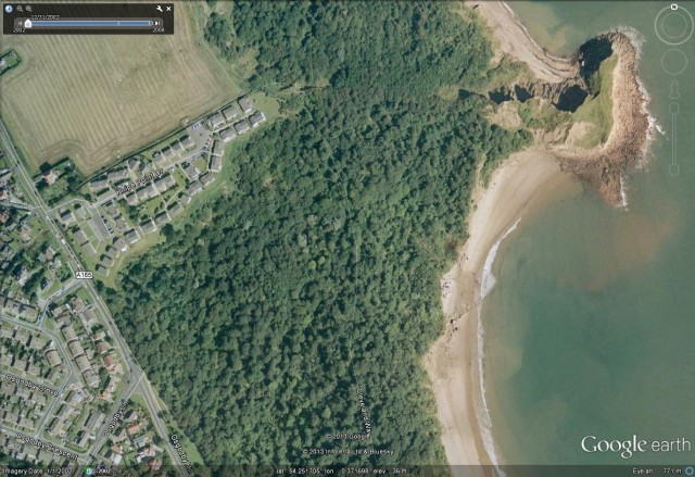
Before (2002 from Google Earth)
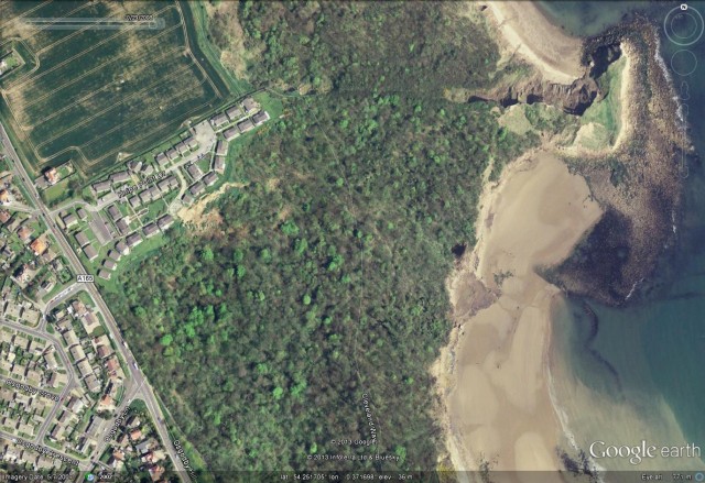
After (2008 from Google Earth)
Unsurprisingly, in the current very wet weather in the UK the landslide has reactivated, and a further four houses are now to be demolished. Given the degree to which landslides have been active across the UK in recent months, this is not unexpected. However, a war of words has now broken out between the owners of the houses and the local water company (Yorkshire Water) and a local chip factory (McCain’s) over who is responsible for the landslide. The residents have always been suspicious of aspects of the landslide – and in particular on whether a leak in the water pipe that takes waste water from the McCain’s factory, inland of the site, to be discharged to the sea might be responsible. The residents had observed that water flow was intermittent, which suggested to them that a leak in the pipe might be responsible. Unsurprisingly, Yorkshire Water and McCain’s take a different view.
In the context of most recent landslide events, the residents have been vocal about this issue. Their case is supported by a consultant’s report that they commissioned to examine the water chemistry both in the pipeline and on the cliff. The report is available online here – the conclusions are clearly stated:
“In conclusion, based on the testing undertaken to date and the assessment of the results the most likely source of the water issues at the cliff below Knipe Point appears to be the Yorkshire Water pipeline to the north of the site, as recent improvement works appear to have remedied the problem of the frequent water issues. In addition there is a strong correlation between the chemical content of the issuing water and the effluent water in the pipeline.”
I am no groundwater chemist, so am not qualified to comment on the analysis that is contained within the report. However, I do find it surprising that water issuing from the cliff contained for example starch. However, this weekend Yorkshire Water have responded with a claim that the water has not come from their pipes:
But last night Yorkshire Water responded to claims that water appearing from the cliff at Knipe Point was coming from its pipe which serves McCain’s factory. It said: “We’d like to reassure everyone concerned that our investigations show that our pipe is not to blame in any way for the recent land slippage. Our own checks have also confirmed that the water coming from the cliff is not potable water, meaning that it hasn’t come from any of our drinking water supply pipes in the area. Available evidence would seem to suggest that the landslip was simply an act of nature. Certainly this theory is supported by a larger, earlier study, conducted by the council, which concluded that this stretch of coastline is geologically active, leading to periodic landslips.”
The cause of the movement events over the last five years is unclear. This is a natural landslide that might be expected to retrogress during very wet periods. However, the residents might argue that the allegedly leaking pipe caused a destabilisation of this piece of land, and that in turn meant that the landslide was more active in the recent wet weather. I should stress here that I do not have enough information to take a view either way, and please do not read any of the above as an indication that I think one side or the other has a stronger case, but this is certainly a fascinating subject. While I will watch with interest what happens next, the very difficult circumstances in which the owners of these houses find themselves must not be forgotten.
It would be interesting to see comments from those who are better qualified in geochemistry than am I.
7 February 2013
Landslide oddities number 2: please get baboosh off in the bathroom…
Part two in the series of landslide oddities. Part One is here.
Hard to know quite what this means, but I can’t help but feel that it may well be good advice…

http://www.telegraph.co.uk/travel/picturegalleries/signlanguage/9850306/Sign-Language-week-242.html?frame=2471560
Image source = Daily Telegraph
6 February 2013
Probably the largest mass movement ever recorded on video
In this case a mass movement of ice, not rock and soil, on the Ilulissat Glacier in Western Greenland, a part of the film Chasing Ice. It is genuinely astonishing – the volume of the collapse is apparently 7.4 cubic kilometres.
.
Note how the system progressively destabilises. The failure event is absolutely fascinating.

.
Thanks to Ellen Hardy and Peter Weisinger for the heads up. My host research institute, IHRR, has arranged a showing of the film, and a panel discussion, in conjunction with the Star and Shadow Cinema in Newcastle on 18th April.
5 February 2013
Landslide oddities number 1: arresting a felon
This is the first in what I hope will be a series of posts on landslide oddities. Thanks to both Ellen Hardy and Alexandre Mathieu for their help with this one.
KVAL.com yesterday carried the story of Cody Pettit, who stole a taxi at knife point on Saturday, and set off for a joyride in Brookings, Oregon, USA. He was spotted by a police officer, who duly gave chase. This ended somewhat abruptly when Pettit turned onto a minor road, only to crash into a landslide that was blocking it:
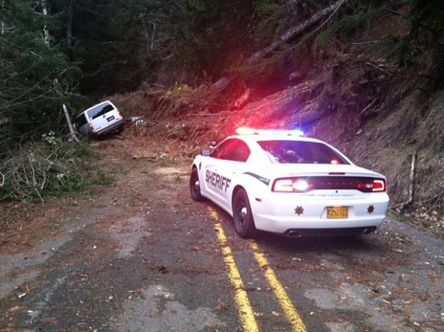
http://www.kval.com/news/local/Sheriff-Landslide-halts-man-in-stolen-taxi-189730801.html
Pettit was duly arrested and has now been charged with “Robbery in the First Degree, Attempt to Elude by Vehicle, Unlawful Possession of Methamphetamine, Reckless Driving, Criminal Mischief 2nd Degree, Menacing x 2, Harassment x 5, Reckless Endangering, Theft of Services, Unauthorized Use of a Motor Vehicle, and Coercion”.
Officers have yet to disclose whether the landslide is in line for an award.
 Dave Petley is the Vice-Chancellor of the University of Hull in the United Kingdom. His blog provides commentary and analysis of landslide events occurring worldwide, including the landslides themselves, latest research, and conferences and meetings.
Recent Comments