

1 February 2013
Landslides and rural roads in high mountains – an example from Nepal
Accounting for changes in landslide patterns with time is very difficult. Collecting the underlying datasets is problematic in itself (still requiring mapping by hand in most cases) and, of course, landslides result from a combination of a whole range of natural and human factors, all of which change with time. It has been frequently postulated that one of the underlying causes of the increase in landslides in mountain areas in less developed countries is road building – indeed in a paper that I wrote with some colleagues a few years ago (Petley et al. 2007 – drop me a line if you want a copy) we proposed that inappropriately engineered road construction might account in large part for the increase in landslide impacts in Nepal over the last 20 years or so.
As part of the Earthquakes Without Frontiers project we will once again be working in Nepal over the next few years. I am genuinely delighted about this – Nepal is a quite wonderful country, but the landslide problem there is severe. The main aspect of our work will be to think about the threat posed by earthquake-induced landslides, and a major issue here is the way that road networks will be disrupted when a large earthquake occurs. So, this morning I was looking at the ways that road building has changed the landscape in Nepal in recent years, and came across this really interesting example from Central Nepal. The area in question lies close to the Prithvi Highway, which is the main access road from the southern plains through the mountains to Kathmandu. The rural road in question, which is in the very southeast of Gorkha District, is a small road that links to the main Prithvi Highway and passes through a settlement called Ghyalchok before climbing over the ridge, ultimately joining another road near a settlement called Darbung Phant (see Figure 1 below). The mountains here are large, but they are not the huge snow-capped high Himalaya to the north. The road w, which starts at about 300 m above sea level and climbs to about 1300 m, was presumably constructed to link the many ridge-top communities to the main road network, and as such is typical of thousands of roads being built in Nepal. The road, which is almost certainly unsurfaced, can be seen as a thin brown line on Fig 1.
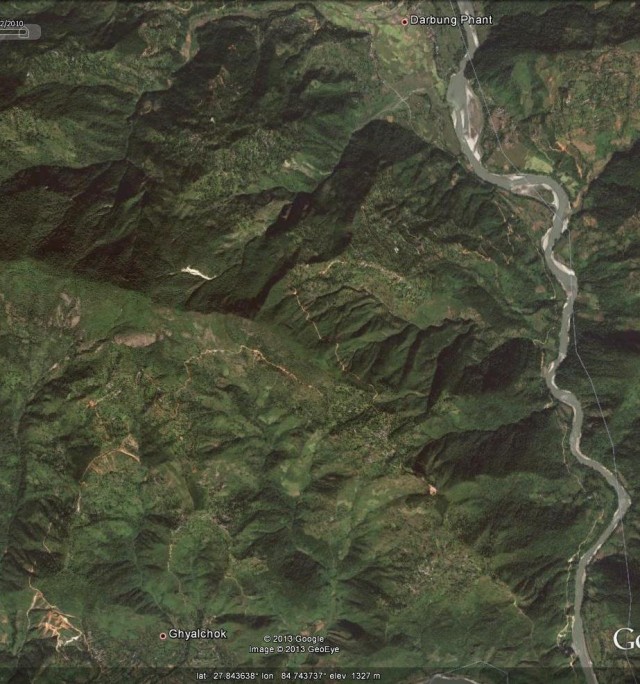
Fig 1: Google Earth image of the road in central Nepal. The road is the thin brown line that wins its way through the hills between the two settlements from bottom left to top right
If you look carefully you should be able to see that in several places the road has a series of quite large landslides along its length. The most obvious set is in the bottom left corner:
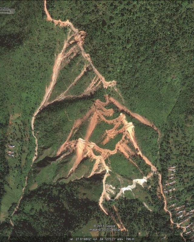
Fig 2: Landslides along the rural road as shown in the 2010 Google Earth image
The nature of these landslides becomes quite clear when they are viewed draped on the digital elevation model (Figure 3). Note the way that some landslides triggered by the road have spilled onto the road itself further down, multiplying the problems:
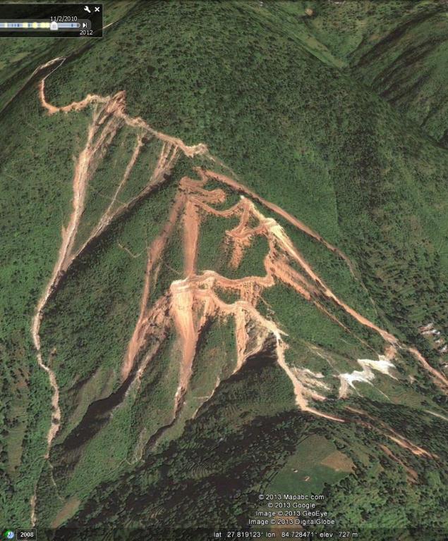
Fig.3: A Google Earth perspective view of the landslides on the rural road in Central Nepal
This imagery was collected in February 2010. Interestingly, Google Earth also has an image from March 2009 (less than a year before), which was before the road was constructed. Fig. 4 shows the same perspective view of this imagery as in Fig 3. The line of the road is traced out on the image, but note that the road had not been constructed. At that time there was just a walking track across the hillside.
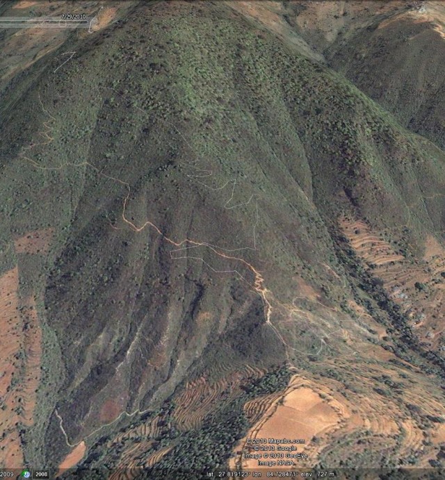
Fig 4: The 2009 Google Earth perspective view of the line of the rural road in Nepal. Note the absence of both the road and the landslides
The difference between the two images is startling. Before the road was constructed there were no landslides at this site. Clearly the slips are a substantial threat to the viability of the road, and will have serious impacts on the communities if they become dependent upon the road for their livelihoods. However, the threat is more serious than this I think because the two largest landslides runout perilously close to the road and the adjacent houses (Fig. 5):
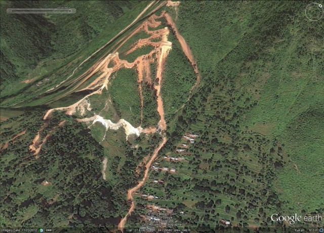
Fig. 5: Google Earth perspective view showing the proximity of the landslides to houses
In a cloudburst event, which occur occasionally during the monsoon, these landslides have the potential to turn into very devastating debris flows (such as the famous Hong Kong event of a few years ago, shown in the video below). In such conditions road users and the inhabitants of some of these houses would be at high risk. And of course we have no idea how these systems would behave in an earthquake.
This pattern is repeated right across Nepal. I am not against increased road building in the mountains. However, preventing these types of landslide problems is comparatively simple and inexpensive, and has the potential to improve both livelihoods and safety. If we are to reduce losses from landslides then it is this sort of problem that needs to be tackled systematically.
Reference
Petley, D. N. and Hearn, G. J. and Hart, A. and Rosser, N. J. and Dunning, S. A. and Oven, K. and Mitchell, W. A. (2007) ‘Trends in landslide occurrence in Nepal.’, Natural hazards, 43 (1): pp. 23-44.
30 January 2013
A call for landslide photos for the USGS library archive
 .
.
Lynn Highland, a Geographer with the Landslide Program of the U.S. Geological Survey (USGS) is joining the USGS Library in a project to compile an archive of copyright free, high-resolution (if possible) photographs of all aspects of landslides. These contributed photos would be archived permanently with, and obtainable through, the USGS Library website, which can be accessed here:
http://libraryphoto.cr.usgs.gov/index.html
The photographs archived at the library are public domain and can be downloaded for free by anyone accessing the website. More information about the library and how it works can also be found at the website.
Lynn has asked if you would consider submitting your best photographs by sending the photos in as high a resolution as possible, with a caption, and credit. The photos will be searched by users, using key words, so including as much information as possible in the caption is desirable. If you are willing to support this initiative by providing some photographs then please send them to:
Lynn Highland using this email address: [email protected]
You may attach them, along with a text description, or send a website or file-sharing site where they can be accessed.
All types of landslide photos will be gladly accepted – those affecting the natural and/or built environments, those illustrating types of landslides, engineered and remedial sites, rockfall, debris flow, creep, lateral spreads, lahars, volcanic landslides and of course, “mudslides” which many users use as a search term.
If you’re unsure about whether the photo is useful, please send it anyway! Someone is always looking for good quality, non-copyrighted, landslide photos, and your photo could be the one they are looking for!
If you know of others who might want to contribute photos, please let them know about the USGS project. And please send any questions about the process to Lynn.
I thoroughly approve of this type of initiative and will be sending some images of my own. Such an archive is invaluable for research, teaching, presentations, books etc. Please do submit half a dozen or so photographs.
An unusual quarry landslide in Canada yesterday
A somewhat unusual quarry landslide occurred yesterday at the Maskimo Quarry in L’Epiphanie in Quebec, Canada. Montreal CTV News has a good aerial image of the site and the landslide:
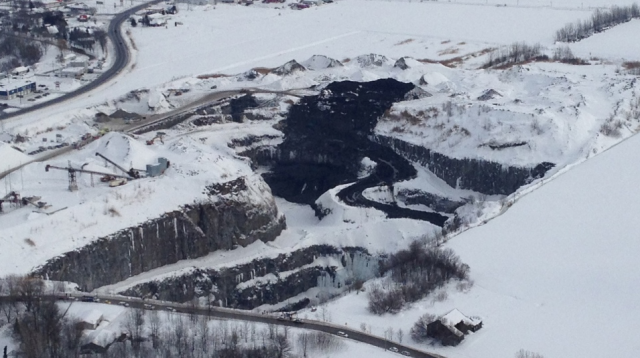
http://montreal.ctvnews.ca/search-suspended-for-workers-missing-in-collapsed-quarry-1.1134230
On initial inspection the slip appears to have originated in the materials in the slope above the main quarry face, and then to have cascaded over the edge into the main excavation. Sadly, there were two trucks and excavator on the slope at the time, all of which ended up in the 100 m deep pit. One of the three people operating this equipment was recovered with only reasonably minor injuries; the other two remain missing. The image below, from the Montreal Gazette, shows just what a difficult task the rescuers face:
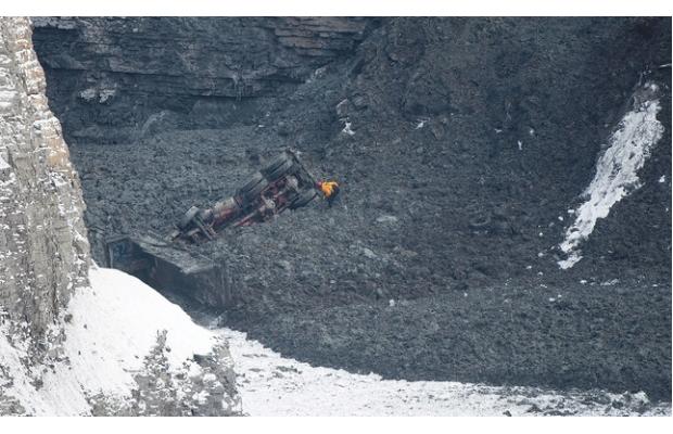
http://www.montrealgazette.com/news/montreal/Workers+missing+after+quarry+land+slide+%C3%89piphanie/7887851/story.html
It appears to me that the access road for the main excavation has also been buried, which will hamper the recovery operation.
29 January 2013
A round up of just a few of the recent landslide events
In the last few weeks there has been an unusual amount of landslide activity worldwide. This is just a few of the more interesting events, there are many more that I’ll try to cover in the next few days. Thanks to everyone who has pointed them out to e, and apologies if I have not acknowledged your contribution or covered your story yet. Please do keep them coming!
1. The raw footage of the Mount Dixon Rock Avalanche
The original video of this landslide in New Zealand is now available here (hat tip to Eric Miller for finding this). It is genuinely amazing. In fact the motion is even more complex than I had appreciated at first in two ways. First, in the early part of the video the landslide appears to have a more rapid movement component on the left side (as seen from the camera). I would not have guessed this from the morphology of the deposit. Second, the landslide continued to creep for a considerable period after the main motion ceased, and it was this creep that caused the bull dozing of the snow at the landslide snout. Very interesting indeed, and a perfect illustration of just how complex landslide motion can be.
2. Successful mitigation of the Braldu Valley landslide but continued hardship at Attabad
I can only admire the people of the Skardu area of Northern Pakistan for their pragmatic response to the hazards posed by the valley blocking landslide in the Braldu valley. The tribune newspaper in Pakistan reports that “An artificial lake formed accidentally in Shigar valley of Gilgit-Baltistan (G-B), this week, is draining gradually after officials and local volunteers dug a spillway through the debris on Saturday…As the news of the river’s blockade spread, civilian and army authorities rushed to the valley to get first-hand information. We hope the situation will normalise soon, said Basharat Ali, a government official in Skardu. By the time a spillway was carved out, the lake had expanded up to four km upstream and had gained 100 feet in height.” Meanwhile, three years on Attabad continues to cause enormous hardship. Weather conditions in the valley are now poor, such that the lake has frozen over, preventing the boat service from operating. This in turn is causing very real problems for the communities upstream. Thanks to James for finding the key news story about this situation over the weekend,
3. Rockfalls!
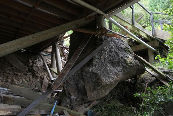
A spate of rockfall events has also been in the news around the world. In Christchurch, a boulder detached from a cliff in Sumner last week and struck a house. The property had been red-zoned but appears to have been occupied at the time:
http://www.stuff.co.nz/the-press/news/christchurch-earthquake-2011/8216018/Van-sized-boulder-overhangs-home
.
It is the severity of this threat that has driven the (very necessary) rockfall hazard and risk assessment work in this area. This event catalyzed the discussion once again, leading to the Canterbury Earthquake Recovery minister Gerry Brownlee declaring I told you so, but local residents responding with claims that protection work would manage the hazard. It is however really challenging to defend large numbers of houses against 40 tonne boulders.
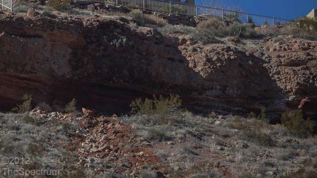
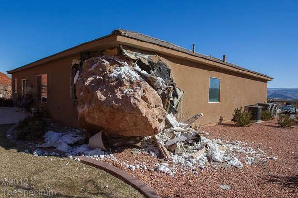
Meanwhile, the potential impact of these events was illustrated in St George in Utah, where a woman had a very lucky escape when a very large boulder crashed into the corner of her house in the middle of the night. She was pinned under the boulder, breaking her jaw and sternum, and inflicting additional injuries. There is an excellent gallery of images of the event here, from which these two photos, showing the source and the house are taken:
http://www.thespectrum.com/article/20130119/NEWS01/301190004/Boulder-crashes-into-St-George-home?nclick_check=1
http://www.thespectrum.com/article/20130119/NEWS01/301190004/Boulder-crashes-into-St-George-home?nclick_check=1
.
4. A retaining wall failure video from Spain
Over in Spain heavy rainfall inthe last few days has also induced numerous landslides and severe flooding in the Basque country. Thanks to Gaizka Garmendia Dios for pointing out the footage here, which captures the moment that a retaining wall collapsed. A subsequent section of the video shows a later shot that demonstrates that another large section of the wall collapsed later in the day. If you look carefully you can see the extensive deformation in the wall at the top of the slope as well.
28 January 2013
The video of the Mount Dixon (Aoraki Mount Cook) rock avalanche in motion
 .
.
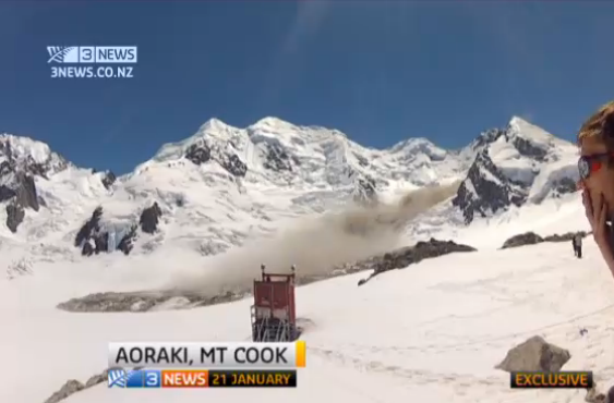
At the time of the rock avalanche on Mount Dixon in Aoraki Mount Cook in New Zealand last week it was reported that at least one of the occupants of the Plateau Hut caught the video in action. This has proven to be the case – 3 News NZ has obtained the footage from the climber – Neil Wiltshire – and has a nice report that features it. At the moment I cannot embed it, but you can view it here:
The really interesting element is the transition of the movement from a turbulent rock avalanche to an almost intact mass sliding on the ice base. The footage at around 50 seconds initially shows a turbulent flow, which is generating a huge amount of dust. However, at the end of that sequence it appears to transition to sliding mode (which is shown in the image above), so that ion the section at about 1:15 (and indeed at the start of the video) the landslide appears to be gliding on the ice with almost no apparent internal deformation.
It would be really good to get hold of the full video – hopefully this will emerge in due course.
25 January 2013
Another valley blocking landslide in northern Pakistan
First, can I just note that there is an awful lot going on in the landslide world at the moment. I could blog on any of about a dozen different stories – quite remarkable. I’ll try to put a summary post together soon, but unfortunately am very busy in my day job right now.
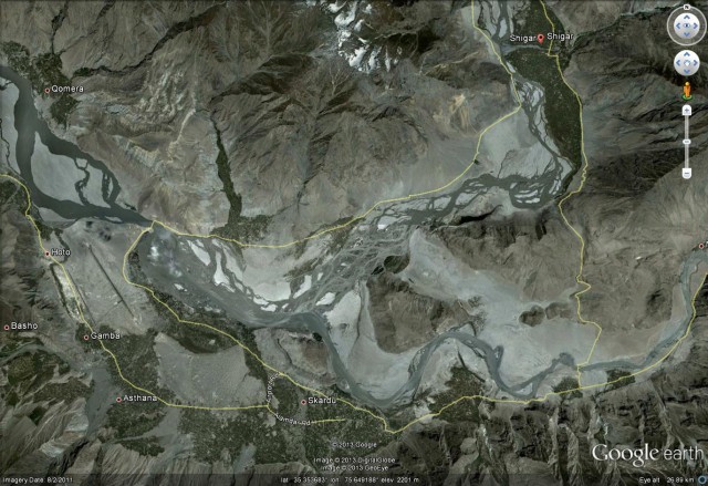
Three years ago, In January 2010, a large landslide in Northern Pakistan caused enormous disruption. The landslide at Attabad, with which this blog was closely involved, remain unresolved, such that it affects the daily lives of thousands of people. The ever-impressive Pamir Times, and various other newspapers in Pakistan, are now reporting another valley-blocking landslide in the same region, this time at Shigar in Skardu District. This area is shown on the map below – according to Google Earth Shigar is in the valley above Skardu:
.
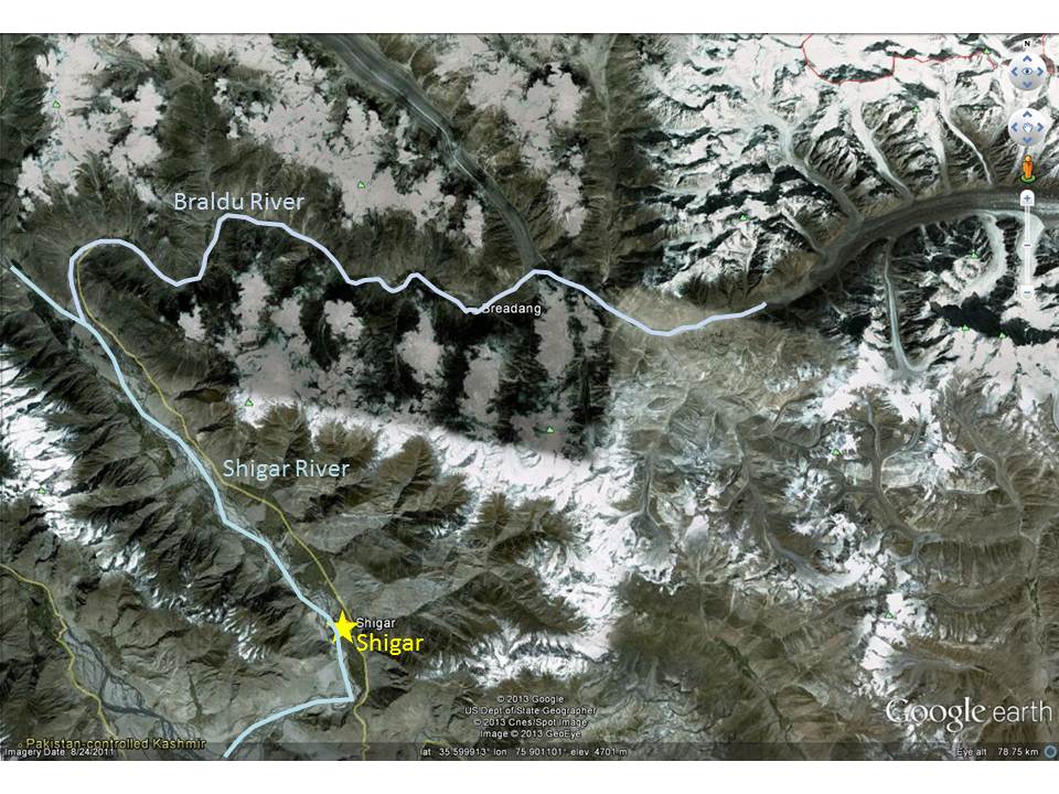
However, the Braldu River, which is reported to be blocked, is to the north of this area. I have annotated the map below to show the river and the main towns:
 .
.
The Braldu River flows westward over a course of about 70 km, fed by the Baltoro and Biafo glaciers, before reaching the main valley to join the Shigar River. The Braldu valley includes a number of settlements and a road that provides access to the town of Askole, which is the starting point for many mountaineering expeditions in the Karakoram Mountains, including K2.
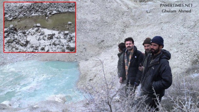
At the moment it is difficult to know how bad the situation is at this site. The Pamir Times reports that the valley is blocked and that a lake is building, and they have a picture that appears to confirm this:
http://i1.wp.com/pamirtimes.net/wp-content/uploads/2013/01/Braldu-River-lake.jpg
.
However, it is impossible to assess the scale of the landslide from this image. They also report that:
Imran Nadeem Shigri, former Tourism Adviser, has said that the newly formed landslide lake in the Braldu valley of Shigar, Skardu District, can prove to be disastrous for the region’s economy, if it is not dealt with on emergency basis. In a press statement, the senior PPP leader has said that the Braldu River Lake is as sensitive as the dammed Hunza River – blocked by a landslide at Attabad since January 2010.
Clearly this landslide requires urgent attention. I can only hope that it proves to be less serious than the above quote suggests.
23 January 2013
An analysis, based on Images and video, of the Mount Cook National Park landslide on Monday
The large landslide on Mount Dixon in the Mount Cook National Park in New Zealand on Monday has now been photographed and videoed in some detail, providing a clearer picture of what happened. This is a very impressive landslide with a large fall height and long runout distance, although as far as I can see there is nothing surprising about its behaviour. A good starting reference point is the following Youtube video:
http://www.youtube.com/watch?v=s9G6aI49Le0
.
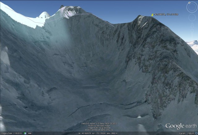
Landslide source
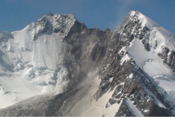
The mass appears to have fallen from a near vertical cliff on the west face of the southern flank of Mount Dixon, removing a section of the ridge-top in the process. The scar left by this section can be seen in the image below (from here):
 .
.
The area of detachment can be seen in the Google Earth perspective view based on imagery from 2007:
 .
.
Fall height
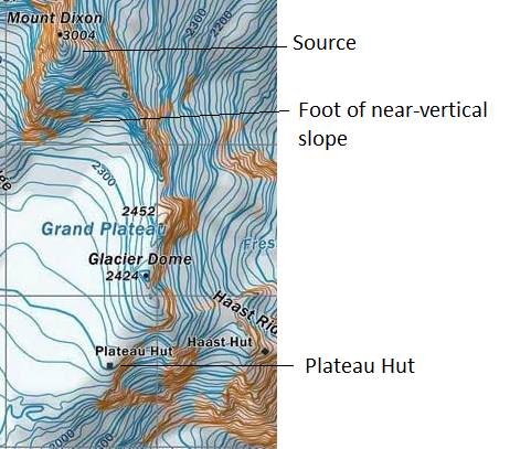
The map below (from here) shows the area affected by the landslide. This suggests a maximum fall height of about 450-500 metres from the ridge to the foot of the steep slope:
.
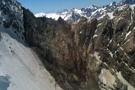
The photo above suggests that the topography of the slope may have concentrated the debris into a comparatively small initial impact zone. 3News has a better image of the source zone – it is not difficult to understand why this mass was unstable:
 .
.
The landslide track
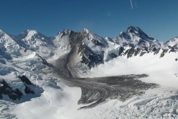
The landslide track is shown well in this image (from here):
 .
.
The track appears to have two components – a concentrated main zone from the focused impact area at the slope toe, in which the landslide appears to have removed all of the surface layers of snow and ice, and a more dispersed zone on each side in which the landslide appears to have run across the snow without eroding it away. The landslide has clearly followed the topography. There is an interesting transition at the foot of the concentrated zone (just below and to the left of the centre of the image above) at which the landslide appears to have stopped eroding the snow and ice and to have started to deposit, but this is not clearly resolved on the photos. The landslide track is about 3 km with a total vertical change (from crown to toe) of about 800 metres.
The runout zone
The termination of the landslide has a quite beautiful structure, with a series of lobes containing flowlines. It is clear that the landslide ran out of energy when the slope gradient reduced. On the left of the image above the flow has started to travel downslope in two or so lobes as the glacier steeoened, but these appear to have been too small to maintain the flow. The deposit, shown in the image below (from here), is clearly a mixture of ice, rock and snow. Notice how the dust deposit (which provides a fuzzy edge to the landslide further upslope, appears to disappear in the lower reaches. In all cases at the toe of the landslide the edge of the lobes of the deposit seems to consist of bulldozed snow There seems to be more rock below the main track area (on the right of the image) below than in the other sections (especially to the left of the image below). The Plateau Hut, also shown on the map above, is circled. If nothing else it provides a good scale for the landslide.
 .
.
A post on this link suggests that some of the climbers may have caught the video in action, but that they are still climbing at the moment. I am hoping that this might become available in due course.
Comments or thoughts welcome, and thanks to the many people who have provided links to this event.
21 January 2013
First reports of a large landslide on Mount Cook in New Zealand
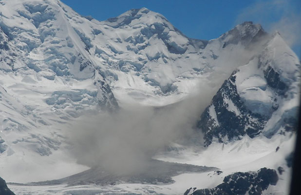
Several newspapers are reporting that a large landslide occurred today on the flanks of Mount Cook. The best report is in The Press, which has an image (below) and a description of the landslide:
“A Department of Conservation spokeswoman from the Mt Cook office said the rockslide happened just after 2.30pm today. “It’s quite massive and I think it has left a scar on the mountain. I haven’t heard of one this big before; not since the one in December 1991.” Rocks fell more than 600 metres down the mountain, she said. She said 13 people were staying at the nearby Plateau Hut, but nobody was injured.”
 .
.
Hopefully some better images of this will emerge tomorrow. This appears to be a rock avalanche with quite a large fall height, not unlike (but smaller than) the 1991 event on the same mountain.
19 January 2013
An interesting landslide in the Great Smoky Mountains
Thanks to Dana Soehn of the Great Smoky Mountains National Park for the images and explanation and to Ellen Hardy for both bringing this to my attention and linking me to Dana.
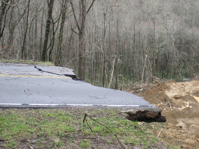
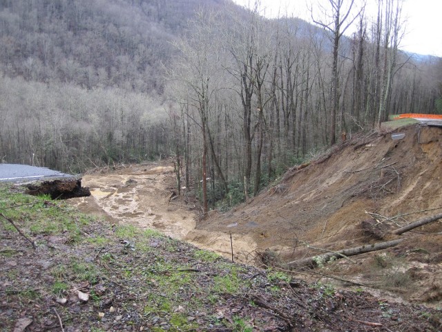
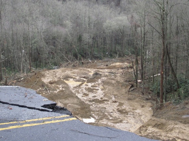
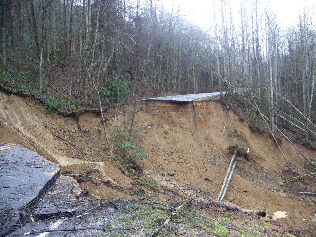
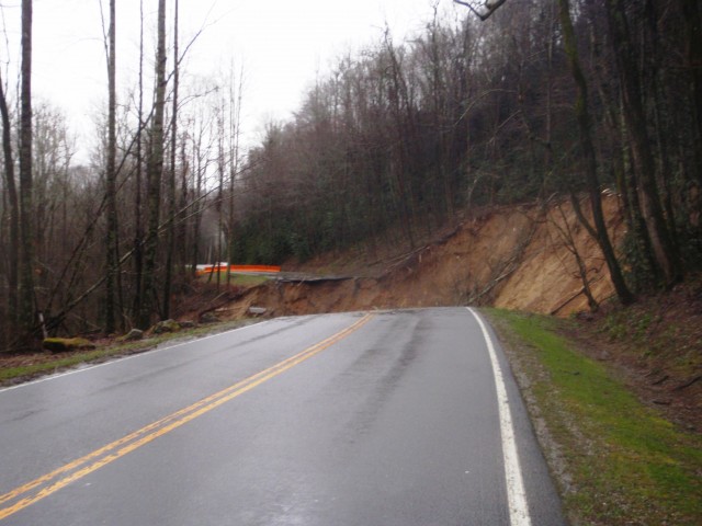
On 16th January heavy rainfall in the Great Smoky Mountains National Park in North Carolina triggered a large landslide that destroyed about 200 m of Newfound Gap Road (U.S. 441). As the National Parks Service estimate that the landslide has a volume of about 70,000 cubic metres, and at least some landslide activity is continuing, it will take a while to reopen the road. The National Parks Service has very kindly provided the following images of the landslide:
18 January 2013
An intriguing very large landslide dam and breach event from March 2012 in Peru
There is a very intriguing video on Youtube, posted this week, which provides a series of photographs of a large landslide dam breach event in Peru. The accompanying text says:
In March 2012 there was a massive landslide in Huaraz, on the famous and breath-taking Santa Cruz Treck [sic]
http://www.youtube.com/watch?v=EcnRtHkmhRY
.
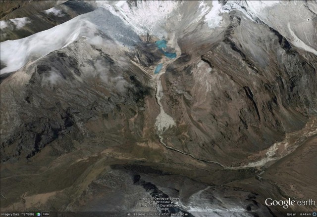
The location appears to be this valley, as shown in a Google Earth perspective view:
 .
.
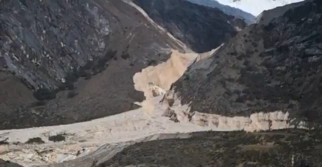
This looks to be a fairly spectacular breach event, as the screenshot from the video below shows, but it is very unclear as to what happened and when.:
 .
.
The Google Earth image is ten years old, so is not much help. A few trekking sites refer to the landslide – so for example this one says:
In March 2012, a combination of heavy rains and an avalanche created a massive landslide in the Santa Cruz valley, starting in the corrie between Nevado Artesonraju and Nevado Paria and sweeping down the valley. The hillsides were ripped away, the Rio Santa was diverted, and the once steep-sided Santa Cruz valley was filled with millions of tons of rock and earth. Amazingly, nobody was killed. While I was aware of the landslide and the new route the path now took, I was not aware that my planned camp site had also been washed away! Worse, the landslide was so strong that any flat, treeless areas were torn up, meaning finding a wild camping spot was also impossible. The only remaining spots were heavily forested and steeply sloping valley edges, and the new vertical cliffs meant getting to the river for drinking water was impossible. Not good.
Does anyone know any more about this event?
 Dave Petley is the Vice-Chancellor of the University of Hull in the United Kingdom. His blog provides commentary and analysis of landslide events occurring worldwide, including the landslides themselves, latest research, and conferences and meetings.
Recent Comments