

12 March 2013
An interesting new rockslide video on Youtube
A new landslide video has appeared on Youtube in the last few days, showing a small rockslide on the coast near to Padstow in Cornwall:
There is not much information about it other than a statement that it was captured by chance whilst out fishing. The quality of the video is unusually high, which means that the collapse event is very well recorded.
5 March 2013
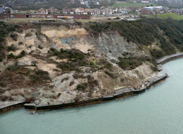
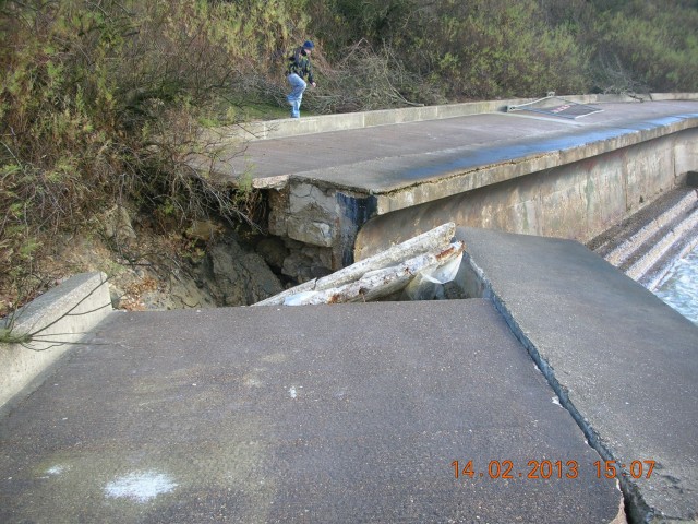
A spectacular landslide from the Isle of Wight
The Isle of Wight Council Facebook page has these images of a landslide at Totland:
 .
.
 .
.
This developed over the course of the winter, probably in response to the recent heavy rainfall.
4 March 2013
New images of the Hatfield Colliery (coal mine) landslide in northern England
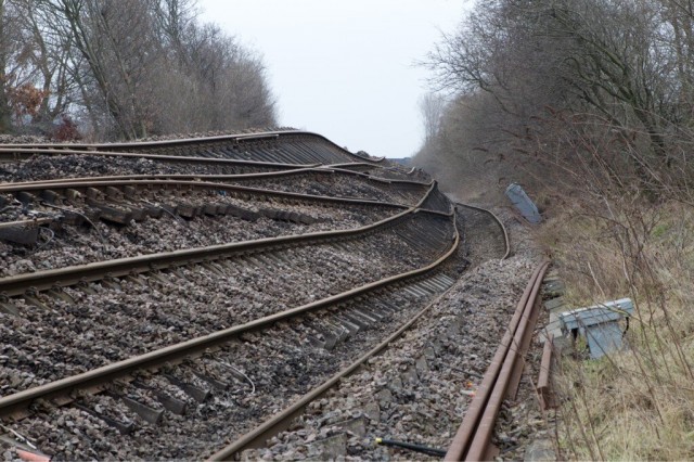
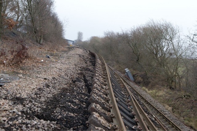
There has been little news from the Hatfield Colliery site for several days now, although Network Rail (the track operators) have revealed that they do not expect it to be reinstated until June, and the costs are expected to be very high. Meanwhile, on Twitter, sammie_spad (who appears to be a train guard) has posted four images of the landslide toe (two of them below):
https://twitter.com/sammie_spad
https://twitter.com/sammie_spad
First thing to note is that the landslide presumably has stopped moving now as whilst it was moving no-one was allowed onto the track. Second, and less obviously, the patterns of ground deformation are really amazing! I am particularly intrigued by the process that is occurring at the foot of the toe bulge – (the right side of the deformed railway line above). Here, the trackside infrastructure and the trees are all leaning toward the landslide (i.e. back-tilted). There are several explanations for why this might have happened – it could be that the loading from the landslide toe has deformed the sediments ahead of the slide, or it could be that the material beyond the track is also a part of the landslide, with a “fault” between the two sections, for example. Any thoughts from anyone?
Unfortunately these images do not tell us what is happening up at the top of the slope.
Meanwhile, the BGS now has a very nice summary page about the landslide on their website. The analysis of the historical maps is particularly interesting.
1 March 2013
Landslide oddities part 3: the ground moves in mysterious ways
First, my thanks to Ellen Hardy for pointing this one out.
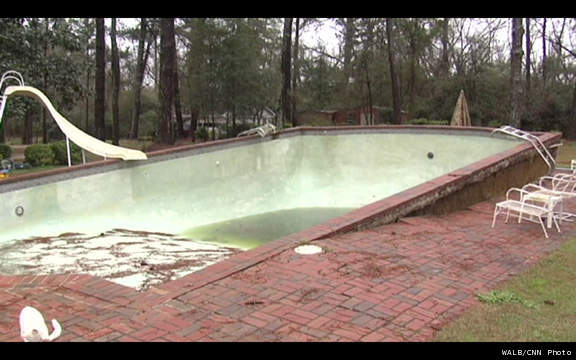
Actually it is not really a landslide, but it is an example of the “strange” ways that the ground can behave. The Southern USA has recently been affected by heavy rainfall. In Leslie, Georgia, a homeowner was somewhat surprised when his empty swimming pool popped out of the ground. WALB News 10 has the full story with a selection of photographs, although the best one is on the News 8 website, which also has a video:
http://www.wtnh.com/dpps/entertainment/must_see_video/heavy-rain-dislodges-swimming-pool-nd13-jos_5632197#.UTBZgtUXKdA
From the WALB News 10 images:

http://www.walb.com/story/21348679/homeowner-shocked-when-pool-pops-out-of-ground
An empty swimming pool is of course in effect a boat. When the groundwater level becomes sufficiently high it will start to float upwards unless it is properly anchored down. In this case it clearly was not.
This does illustrate some of the problems of interpreting the movement of landslides – sometimes strange things appear to happen through simple physics. Landslide movement is usually controlled by buoyancy forces, which technically we term effective stress, operating in a very similar manner.
27 February 2013
Landslides in Art Part 17: Decisive Moment by Chen Po-I
This is the latest of my occasional series of posts about the depiction of landslides in art. Part 16 can be found here.
Chen Po-I is an unusual artist. He trained to Masters Level in Ocean Engineering at National Cheng Kung University in Taiwan before turning to photography. He is now a celebrated photographic artist with a long list of exhibitions. He has a Flickr page depicting some of his work here.
His current exhibition is at the Fotoaura Institute of Photography in Tainan in Taiwan (there is a brief write-up of it in the Taipei Times). The works are interesting and challenging. In 2009 Typhoon Morakot struck Taiwan, bringing extremely heavy rainfall that triggered widespread landslides and debris flows. Chen Po-I has collected a series of images of the destruction that the debris flows caused, focusing primarily on the marks left on walls by the flows:
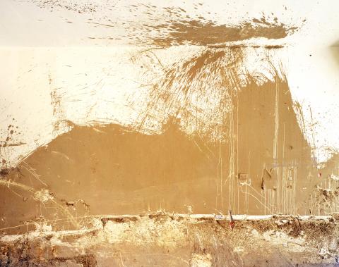
Marakot 2: Photo courtesy of Fotoaura Institute of Photography
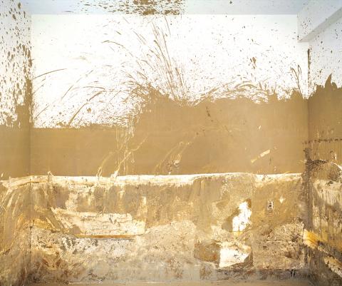
Marakot 4: Photo courtesy of Fotoaura Institute of Photography
Similar photographs to this series can also be found on Chen Po-I’s Flickr page. These images are all rights reserved, so I cannot reproduce them here, but they are well worth a look. It is worth pondering what it would have been like to have been in one of these rooms as these landslides occurred.
26 February 2013
A new, free landslide resource – Community based landslide risk reduction: Managing disasters in small steps
Over at Bristol University in southwest England Malcolm Anderson and Liz Holcombe have been doing some really interesting work over the last few years in the Caribbean, seeking to find ways to enhance resilience to landslides. This has been a highly successful programme that in many ways has not received the recognition that it deserves. This work has culminated in a new World Bank publication entitled ‘Community based landslide risk reduction: Managing disasters in small steps’:
 The book can be downloaded as a PDF for free from here:
https://openknowledge.worldbank.org/handle/10986/12239
And it can be read as an e-book online here:
http://issuu.com/world.bank.publications/docs/9780821394564
This is a really important and useful contribution – and one that I recommend thoroughly. For information, the abstract is as follows:
This book has two main aims: to demonstrate to international development agencies, governments, policy makers, project managers, practitioners, and community residents that landslide hazard can often be reduced in vulnerable urban communities in the developing world, and to provide practical guidance for those in charge of delivering Management of Slope Stability in Communities (MoSSaiC) on the ground. The purpose of the book is to take readers into the most vulnerable communities in order to understand and address rainfall-triggered landslide hazards in these areas. Community residents are not just seen as those at risk, but as the people with the best practical knowledge of the slopes in their neighborhood. As used here, ‘community based’ means engaging and working with communities to find and deliver solutions to landslide risk together. This approach leads governments to develop new practices and policies for tackling landslide risk. This book standardizes those elements of MoSSaiC that have led to its successful implementation in the Eastern Caribbean, and that are essential to the overall objectives (such as community engagement, mapping localized slope features, and broad drainage design principles). The book’s nine chapters provide guidance to project managers and practitioners on the entire end-to-end process of community-based landslide risk reduction. While certain chapters are more directly relevant to one audience than another, it is helpful for all audiences to read the ‘getting started’ section of each chapter and be alerted to the nine project milestones.
25 February 2013
Rockfalls shaking a volcanic lava dome apart (including a dramatic video)
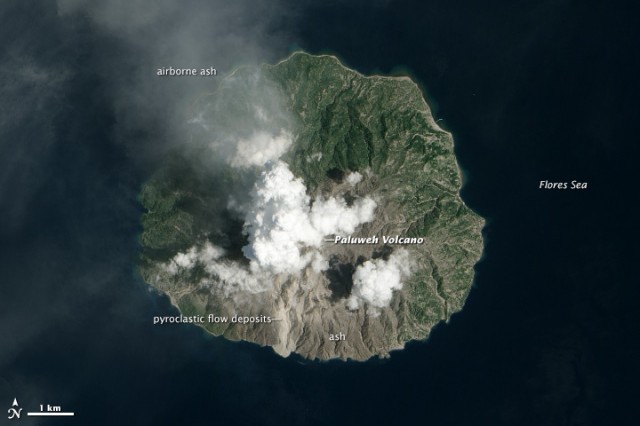
James Reynolds is a video maker based in Hong Kong who specializes in collecting footage of extreme natural hazard events. In the last few days he has been in Indonesia filming the ongoing volcanic event that is affecting Paluweh Volcano in Indonesia. This volcano is currently undergoing a phase of lava dome growth, which over the last few weeks has also been accompanied by eruption events that have generated ash plumes, As is usually the case, this is accompanied by regular seismic events. During his visit to the volcano James caught this amazing footage of the lava dome being shaken by these seismic events, generating rockfalls across he whole of the mass.
For reference, this is a satellite image of the eruption event that was captured by the NASA EO-1 ALI sensor (the same instrument as captured the Mount Dixon Imagery) earlier this month:
http://earthobservatory.nasa.gov/IOTD/view.php?id=80422
.
Interestingly, this footage is somewhat reminiscent of the footage of the effects of the April 2010 M=7.2 earthquake in Mexico (the link is to the old home of this blog).
24 February 2013
An intrepretation of the Mount Dixon rock avalanche in New Zealand using satellite imagery
Last month I posted on a couple of occasions about the Mount Dixon rock avalanche in New Zealand, which was caught on a memorable video by Neil Wiltshire. In the aftermath of the landslide, NASA collected a satellite image of it using their EO-1 ALI instrument. This image, and a comparator image of the site before the landslide, are now available online.
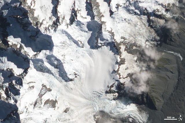
A NASA EO-1 ALI image of Mount Dixon before the landslide
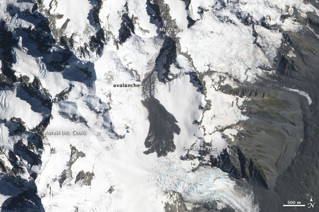
A NASA EO-1 ALI image of the Mount Dixon rock avalanche
As a reminder, this is the video that Neil Wiltshire collected of the landslide:
.
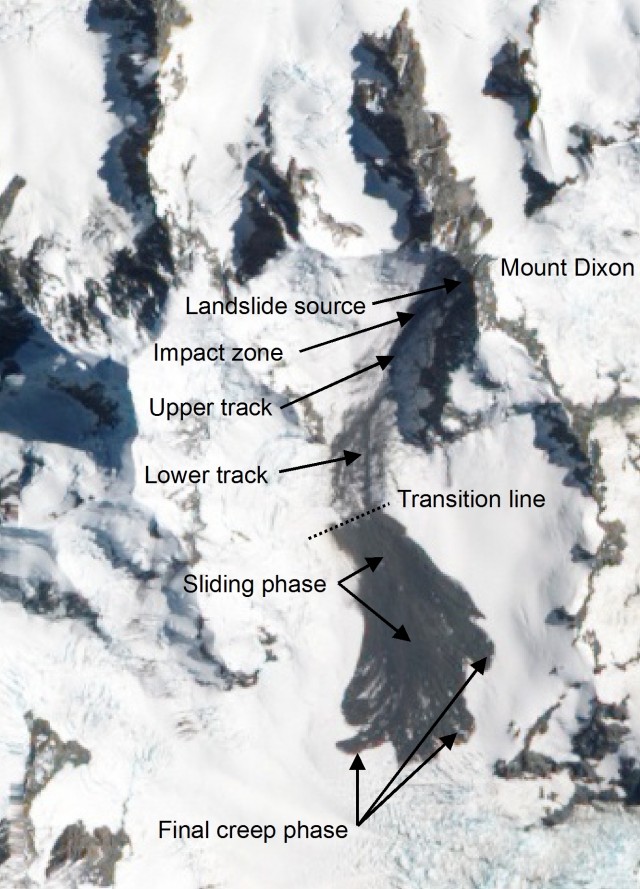
The comparison between the video and the image is very revealing. As I pointed out in my earlier post, the video shows that the landslide with through a rapid transition from a rock avalanche phase (basically a chaotic jumble of rock and ice moving at high-speed) into a sliding phase. If you look carefully at the above image you can see this transition line really clearly. I have annotated the image below to try to highlight the different phases of movement:
 .
.
So my interpretation is as follows:
1. The landslide detached from the near vertical flank of Mount Dixon and fell about 500 metres;
2. In the impact zone it fragmented and transitioned into a rock avalanche
3. In the upper track the rock avalanche has left almost no debris and indeed appears to have eroded away a part of the glacier (in the centre of the track), which will have increased the volume of mobile mass through entrainment
4. In the lower track the rock avalanche starts to leave some small amount of material behind, suggesting the entrainment and deposition are starting to balance. Note that it appears that there are two different erosion tracks in this phase, with the split occurring just above the point that I have marked as lower track.
5. At the transition line the rock avalanche appears to suddenly change into sliding mode, and large-scale deposition starts
6. As the video shows the main landslide motion ends with a transition to a creep phase.
A really interesting question is what this transition point represents? Is this a point at which the slope gradient changes, which means that the landslide rapidly slowed? Or was the landslide losing velocity along track (imagine that velocity was initially high at the foot of the cliff, but the slope gradient was too low to allow that velocity to be maintained). Thus, did the landslide reach a point at which the velocity was too low to maintain an avalanche state? Or thirdly, intriguingly, was this change initiated by a change in the underlying glacier? Take a look at the “before” satellite image – you’ll see that the lower track is characterised by crevasses. At about the transition point this changes to smooth ice. So, did this change in the basal conditions lead to a change in the landslide?
Many people will now be working on this landslide, so I will leave it to them to sort it out. I will try to post again about the landslide when the research is published. There is no doubt that this will provide a significant insight into the somewhat enigmatic behaviour of these large landslides.
22 February 2013
The Bitter Springs landslide in Arizona, USA
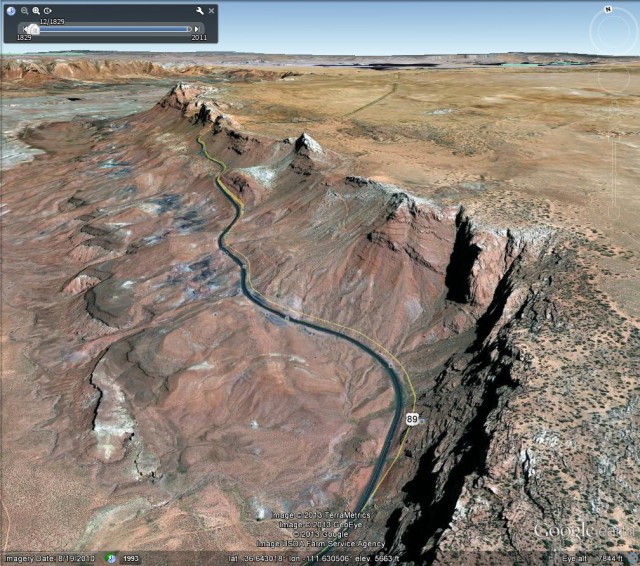
This week a landslide has occurred on US89 south of the town of Page in the vicinity of Bitter Springs in Arizona, USA. Whilst this was initially reported to be a sinkhole, this is very clearly a reactivation of an ancient landslide. It has caused extensive damage to the road, which is now closed:
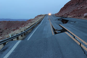
http://www.azdot.gov/CCPartnerships/News/NRel3399.asp
Others in the blogosphere have covered this landslide much better than I ever could, so here is a list of useful links (and thanks to several people who have helped in putting this together):
The Arizona Department of Transport has been providing updates on the landslide, which includes this video of the site:
The ADOT blog also has a nice post about the landslide, which also includes the above video;
Lee Allison, the State Geologist of Arizona, describes the landslide in a series of posts on his excellent blog, including:
- An overview report
- A cross-section through the landslide
- A historical review
- An analysis of the challenges that face ADOT with respect to this landslide
- An update on the scale of the landslide
- Some geological references for the landslide
- The background geology of the slide
- An interpretation of the ancient landslide setting
- An initial report
The most striking post provides an overview image of the site. I could spend hours trying to figure out the landslide history of this area from this image:
 .
.
Wayne Ranney provides a very elegant summary of the landslide and its setting;
GeoPracNet has a nice video of the landslide taken from a helicopter
I welcome further suggestions for useful analyses or descriptions of this landslide
21 February 2013
Two coal mine landslides – both fatal (including a rockfall video)
Whilst the focus of this blog over the last week has been the remarkable Hatfield Stainforth landslide (for info the lack of updates is because the flow of information from the site has now dried up), two other landslides in coal mines in Asia have claimed lives:
1. A mining-related landslide in Guizhou Province
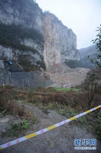
At 11 am on Monday a large rockfall from a steep cliff that was being undermined by a small-scale coal mine in Longchang township, in Kaili city, Guihou Province, China buried five people, including two children. Whilst the remains of the victims have not been recovered, it is now accepted that all of the victims were killed. Interestingly, this landslide has been extensively covered in the media in China, which has released very high quality photos of the site. The best gallery is in the online version of the UK newspaper of the Daily Mail.
http://english.cntv.cn/program/newshour/20130219/104757.shtml
Rescue operations have been hampered by continued rockfall activity – on a very large-scale. One of these remarkable rockfalls was caught on a video that is now available on Liveleak:
2. A coal mine landslide at Antique in the Philippines
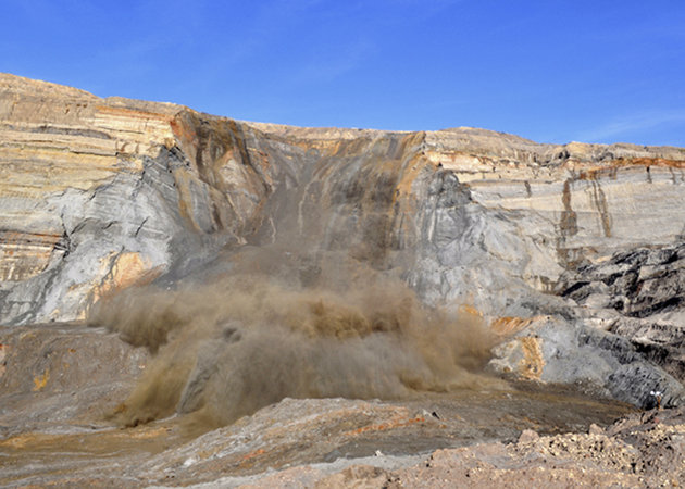
On 13th Feb a landslide occurred in an open-cast coal mine at Semirara in Caluya, Antique in the Philippines. The landslide and its aftermath are very well-described in this article. 13 people were buried, of whom only three have been recovered alive. As with the China example, landslides continued to affect the site after the main collapse, one of which was caught by a photographer:
 Dave Petley is the Vice-Chancellor of the University of Hull in the United Kingdom. His blog provides commentary and analysis of landslide events occurring worldwide, including the landslides themselves, latest research, and conferences and meetings.
Recent Comments