
16 November 2015
The Lidong Village landslide in Zhejiang Province, China
The Lidong Village landslide in China
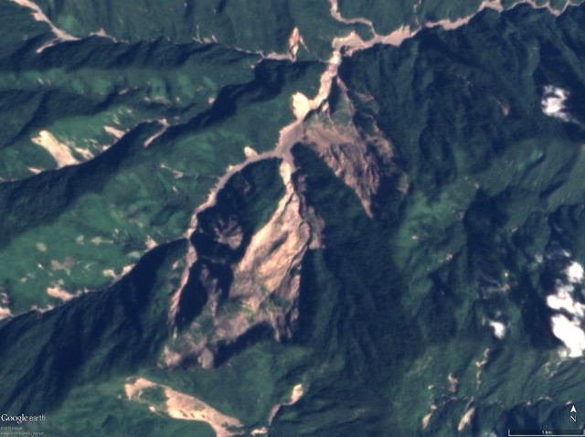
Whilst for understandable reasons it barely registered on the international media radar, China suffered a major landslide on Friday night. The Lidong Village landslide, in Yaxi Township in Lishui, Zhejiang Province in East China occurred at about 10:50 pm on 13th November. At the time of writing 25 bodies have been recovered, with a further 12 missing.
ecns.cn has the best photograph of this very large landslide:
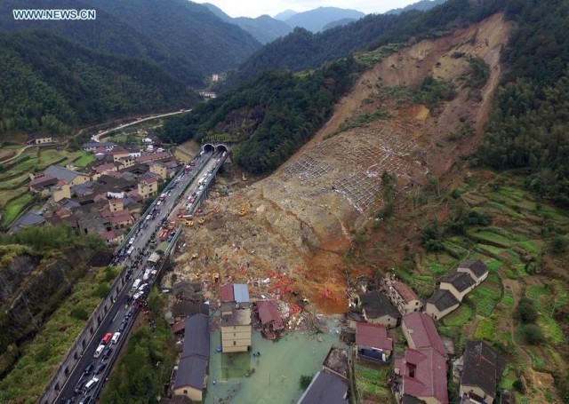
Lidong village landslide via ecns.cn
.
Based on this image the Lidong Village landslide appears to be a large rock and soil slide, mostly formed from deeply weathered rock (I cannot see any unweathered rock in the scar). The slide looks to be quite complex with a number of shear surfaces. Of particular interest is the grid work in the upper part of the main debris accumulation. This is almost certainly slope protection, perhaps soil nails or rock bolts, suggesting that the slope was known to have stability issues The lack of large numbers of trees on the slope suggests to me that the slope had been cleared. However, it is unlikely that the slope protection that us visible was designed to stabilise a failure as large and deep as evidently occurred.
Note also that in the bottom left corner of the image the highway has a rock shelter to protect against instability on a cut slope.
The image below, also from ecns,cn, shows rescuers working through the accumulation of debris. Note that the slope protection is visible in the top corner of the image:
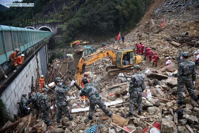
Lidong Village landslide via ecns.cn
.
Xinhua reports that the area was suffering very heavy rainfall at the time of the landslide. As yet there seems to be little online that asks questions as to why this landslide occurred. It is not obvious to me that the road should have disrupted the tow of the landslide, which was on a slope on the other side of a small river. I would be very interested to see an image of this site before the Lidong Village landslide occurred, but as yet have not been able to identify a location.
12 November 2015
The Samarco dam failure – an intriguing video
Samarco dam failure
On Youtube there is a video that provides a compilation of videos that are purportedly from the Samarco dam failure that released a mudslide of tailings that destroyed the town of Bento Rodriguez in Brazil a week ago. The video is over 12 minutes long and has clearly been obtained from elsewhere:
.
The first sequence shows water cascading through the spillway of a dam. I do not believe that this is anything to do with the Samarco dam failure – it does not seem to fit with the observations of the accident.
The second sequence, starting at about 24 seconds, clearly does show an aspect of the disaster. It is not great quality, but my interpretation is that it shows the area of the Fundao dam shortly after its failure. This appears to be be tailings left in the tailing pond:

The Samarco dam site via Youtube
.
Whilst this image appears to be site of the dam itself, or what was left of it. There appears to be a great deal of dust in the air – the remains of the movement perhaps?
Site of the Samarco dam via Youtube
.
This actually seems to be the best footage available so far of the site of the Samarco dam, the Fundao dam, that failed, though it does not shed much more light on the disaster.
The next sequence, starting at about 50 seconds, is the most intriguing. This seems to show a very large mudslide arriving in a small rural community in good weather. The slide is enormous and extremely destructive:
Samarco dam mudslide via Youtube
.
I am unsure as to whether this is the event at Bento Rodrigues caused by the Samarco dam failure, but its fits the known facts. It is certainly a most impressive landslide.
Most of the remainder of the video shows the damage from the landslide, which has been described elsewhere.
Meanwhile the fallout continues. As Samarco and its owners struggle to manage the disaster and the publicity, and of course the likely costs, there are suggestions in the media that there had been warnings two years ago that the Samarco dam was not safe:-
A 2013 report conducted by The Instituto Pristino linked to the Federal University of Minas Gerais, warned of structural design flaws and predicted the circumstances that could lead to a dam burst at the Samarco operation.
“The report had already highlighted the fragility of these structures and the necessity of increased rigor in monitoring them,” Brazilian state prosecutor Carlos Eduardo Ferreira Pinto said.
This report is available online in Portuguese as a pdf. The report seems to indicate the potential for the Fundao dam to be destabilised by proposed works for Samarco. It is unclear as to whether the recommendations were taken up or whether the effects noted here played a role in the accident.
10 November 2015
The history of the Fundao Dam near Bento Rodriguez
The Fundao Dam
It is increasingly clear that the disaster at the Samarco mine that destroyed the town of Bento Rodriguez in Brazil in a mudslide of tailings last week was caused by the failure of one of the upstream structures, the Fundao Dam. Unfortunately as yet I have struggled to track down a decent image of the site of the dam failure. The best I have managed is this YouTube video of the site, which was pointed out in a comment by Caner Zanbak, shot from a helicopter:
.
It is really hard to understand exactly what this imagery shows because the camera never stands back from the site of the former dam. But the images do seem to show near complete destruction of the Fundao Dam itself, and extensive loss of tailings from the pond that it retained. Fortunately the retaining structures to the adjacent ponds appear to be intact. This is approximately the site of the former dam:-
The site of the Fundao Dam from Youtube
.
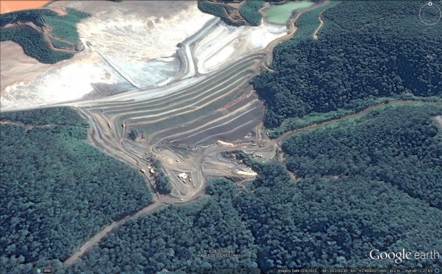
Google Earth has a good sequence of images of the dam site over the last decade. This is the most image of the Fundao Dam, dated August 2013. The video above suggests that considerable work had been undertaken in this area since this image was collected:
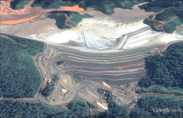
Fundao Dam in August 2013 via Google Earth
.
Back in August 2005 this area was completely undeveloped:
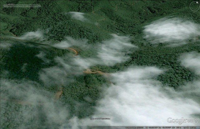
Fundao Dam site in August 2005 via Google Earth
.
By May 2008 the development of this site was underway. Although partially obscured by cloud the dam was apparently under construction:-
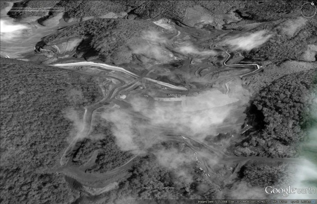
Fundao Dam in may 2008 via Google Earth
.
By February 2011 the dam was fully formed, although less high than at present, and a large volume of tailings was stored behind it:-
Fundao Dam in February 2011 via Google Earth
.
None of these images give any hint as to why the Fundao Dam failed so dramatically. There is no obvious sign of instability in the dam itself, nor in the adjacent slopes, as far as I can see. The most recent image does show an increase in the amount of water flowing from beneath the dam, but this is probably not a factor. The dam does not seem to be located on an unstable piece of terrain, although Google Earth is not up to assessing this properly. It is all very mysterious, and we can only hope that the investigation is open and transparent so that lessons can be learnt.
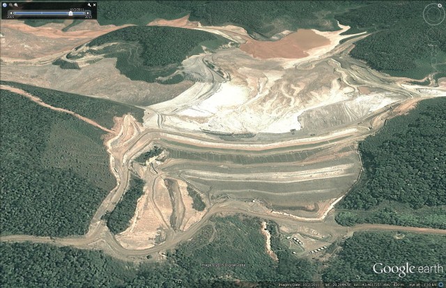
Of interest perhaps this brief report on the website of Reta Engenharia:
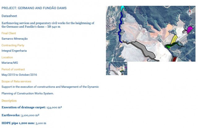
Reta Engenharia website on works on the Fundao Dam
.
But note that the diagram does not seem to show any works on the Fundao Dam itself, and there is nothing that I have seen that indicates that the failure was linked to this project.
9 November 2015
Big news on the Tonzang landslide in Burma – probably the largest non-seismic landslide for a decade?
The Tonzang landslide in Burma
On 29th October I posted about the Tonzang landslide cluster in Burma, which was triggered by exceptional rainfall at the end of July / early part of August this year. There seems to have been at least three exceptional landslides, of which the largest, which I am calling the Tonzang landslide, is very large indeed. This is a NASA satellite image, compiled by Colin Stark, of the landslide:
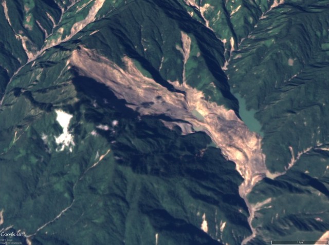
s
The Tonzang landslide, from the NASA EO-1 image. Courtesy of NASA and Colin Stark.
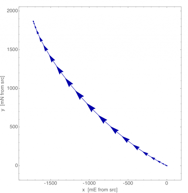
This landslide is 5.9 km from crown to the toe of the deposit. Colin and Goran Ekstrom have gone back to the seismic data and have now found the signal that this landslide generated, which they have then inverted to generate the statistics (see my post about their paper in Science on this for further details). And the results are amazing – the data indicate that the landslide had a mass of 395 million tonnes, which, assuming a density of 2.5 tonnes per cubic metre, yields a volume of about 160 million cubic metres. I believe that this is the largest non-seismic landslide since the 2004 Mount Bawakaraeng landslide in Indonesia (can anyone think of a larger non-seismic landslide in the interim?). By contrast the enormous Bingham Canyon landslide was 65-70 million cubic metres, less than half as large, for example.
Other statistics from the inversion, courtesy of Colin and Goran:
- Mass displacement (source to deposit): ~3.5 km (see the image below)
- Main runout duration: ~160 seconds
- Maximum acceleration: ~2m/s^2
- Maximum speed: ~ 50 m/s
This is the mass displacement record from the seismic inversion, overlain onto a NASA EO-1 image of the Tonzang landslide:
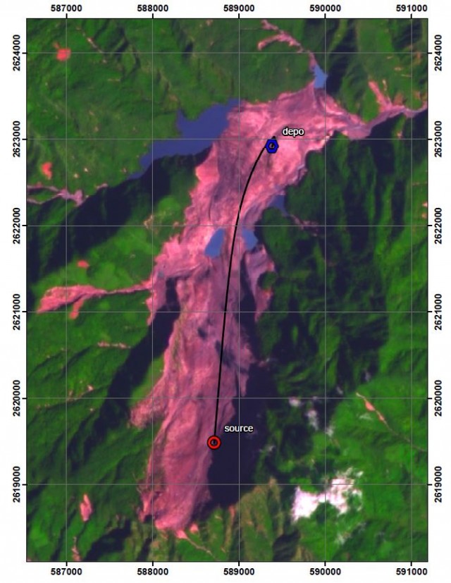
NASA EO-1 image of the Tonzang landslide courtesy of Colin Stark
.
This is the velocity profile of the Tonzang landslide:
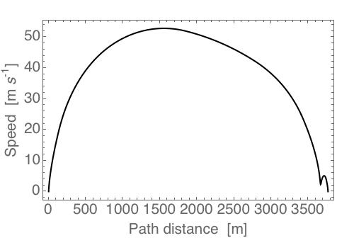
Velocity profile of the Tonzang landslide, courtesy of Colin Stark and Goran Ekstrom
.
And this is the velocity – trajectory plot:
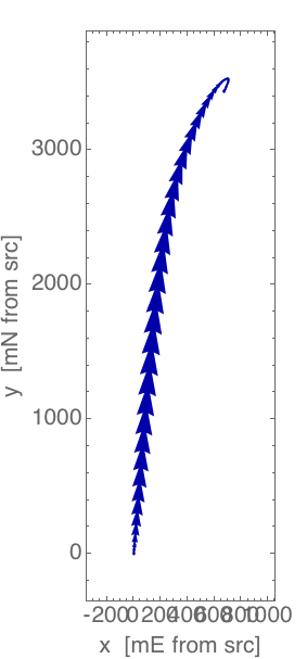
Velocity – trajectory plot for the Tonzang landslide, courtesy of Colin Stark and Goran Ekstrom
.
This is a truly exceptional event, quite remarkable in many ways. There really is an urgent need for someone to go to do some fieldwork to take a look at the Tonzang landslide, it is such a golden opportunity to learn more about very large rock avalanches.
Acknowledgements
To be able to break the news of the largest non-seismic landslide for a decade is an honour. Thanks to Colin Stark and Goran Ekstrom for providing the data and the analyses, and to Stuart Frye and Jesse Allen of NASA for providing the imagery.
8 November 2015
Deciphering the Samarco tailings dam disaster in Bento Rodriguez
The Samarco tailings dam disaster in Bento Rodriguez
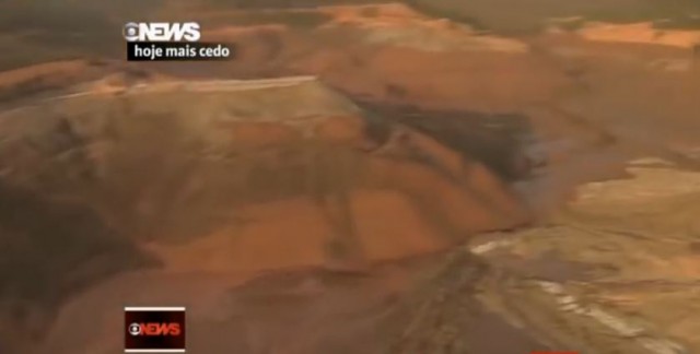
Latest reports from Minais Gerais state is Brazil suggest that there are now two known fatalities from the Samarco tailings dam disaster that devastated Bento Rodriguez, but that a further 28 people remain missing. News reports suggest that about 60 million cubic metres of sludge were released when two tailings dams collapsed. Samarco is now coming in for some criticism for their response to the disaster, and it will be very interesting to see how they handle the inevitable investigation into the dam itself. The fact is that tailings dams should not fail like this – although they do so alarmingly often.
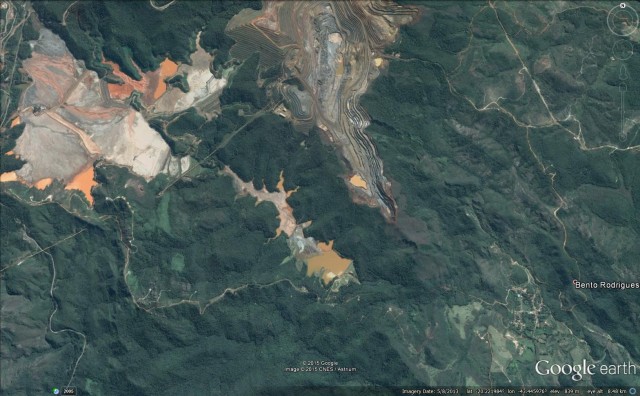
I have seen few images of the location of the source accident itself. The reports consistently suggest that two dams failed. Based on the configuration of the tailings dams, this is most likely to have been the set of dams shown in the Google Earth image below, in which two structures lie upstream of a smaller downstream dam:
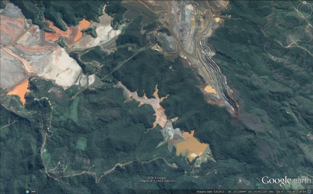
Samarco dam configuration via Google Earth
.
So presumably one of the major structures upstream ruptured, triggering a collapse that then over-ran the smaller downstream dam. The best image I have seen that indicates what might have happened in this one (via Estadao):
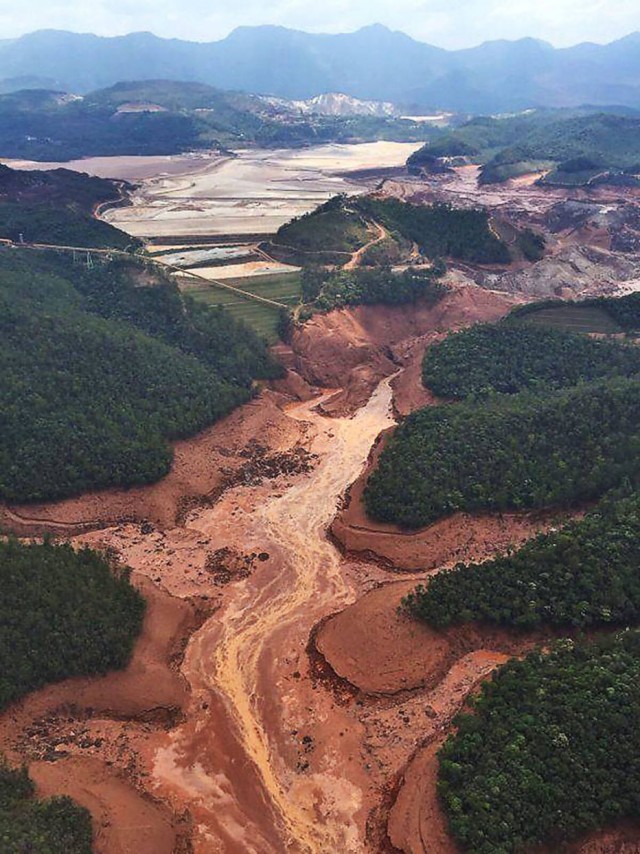
Samarco dam failures via Estadao
.
This image shows the two upstream tailings dams. The left hand dam (the one to the west in the Google Earth image) above is clearly intact, whilst the one to the west appears to have failed. So, based upon this, the problem seems to lie with this dam:
Samarco dam via Google Earth
.
It is hard to know what might have happened beyond this, but the surge that came down the valley was enormous, based on the erosion in the valley below. Note the height of the trimline in the vicinity of the second dam. And of course there is now a vast amount of tailings that are not being retained by any structure. Dealing with this debris must be a priority.
Interestingly there is some information on the internet that there has been recent work to increase the height of at least one of the dams. There is nothing to suggest at this stage that these works had any role in the accident, but it will be a factor in the investigation
6 November 2015
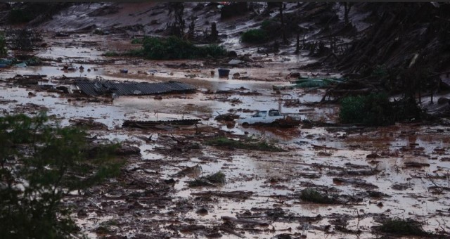
Bento Rodrigues: a disastrous tailings dam failure in Brazil
Bento Rodrigues
There are reports this morning of a disastrous tailings dam failure affecting the town of Bento Rodrigues in Brazil. Current reports suggest that at least 15 people have been killed and as many as 45 more may be missing.
The mudslides that struck the town appear to have been generated by the collapse of the tailings dam associated with the Germano mine, owned by Samarco, which in turn is a joint venture between Vale of Brazil and BHP of Australia. This is a Google Earth image of the setting, although note that this is a couple of years old:
Bento Rodrigues from Google Earth
The best gallery that I have seen is on the uol.com.br website, from which these images are taken. The damage looks near apocalyptic:-
Bento Rodrigues talings dam failure via uol.com.br
.
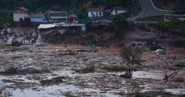
Bento Rodrigues tailings dam failure via uol.co.br
.
In many ways this event is reminiscent of the dreadful tailings dam failure at Ajkai Timfoldgyar in Hungary in 2010, which I covered extensively at the time. Back in 2009 I wrote about an academic study that had been published in a conference in Alberta that suggested that the frequency of tailings dam failures increases when commodities prices fall. The peak in tailings dam failures occurs about two years after the peak in commodities prices. I wrote:
The relationship between the peak in prices an the peak in accidents is ascribed by the authors to:
-
The rush to mine quickly means that design and construction standards may be low;
-
Rapid turn-over of key staff as new (presumably lucrative) opportunities arise during the boom;
-
The boom drives the development of resources in areas that are known to be difficult;
-
after the boom there are pressures to cut costs as commodity prices decline;
-
The boom drives the use of inappropriate designs imported from other locations;
-
There may be a lack of independent review, presumably to avoid the time delays and costs associated with this.
The prices of commodities are currently very low. Iron ore commodities prices peaked in 2011. It would be interesting to see images of the dam itself.
4 November 2015
My latest paper: hillslope preconditioning
Hillslope preconditioning
Hillslope preconditioning is the term we use to describe the possibility that the behaviour of a slope during an event might also be influenced by the legacy of previous trigger events. This idea arises from a damage mechanics approach to landslides, in which the slope evolves to failure through the accumulation of defects – damage – with time. Hence, each successive trigger event causes the slope to degrade until it is ready – preconditioned – to collapse. There are different ways to conceptualise the damage process – for example, it could be that damage occurs through the progressive development of a sliding surface, such that failure occurs in the trigger event that causes it to become complete. Alternatively, damage might accumulate as a degradation and general weakening of the entire rock mass.
The damage approach to landslide failure is appealing in many ways, not least because it fits with observations of slopes prior to failure, which often show large amounts of deformation prior to collapse. This is one of my favourite examples, from Malaysia. Note the extensive damage to the main (rock) slope on the left side of the image:-
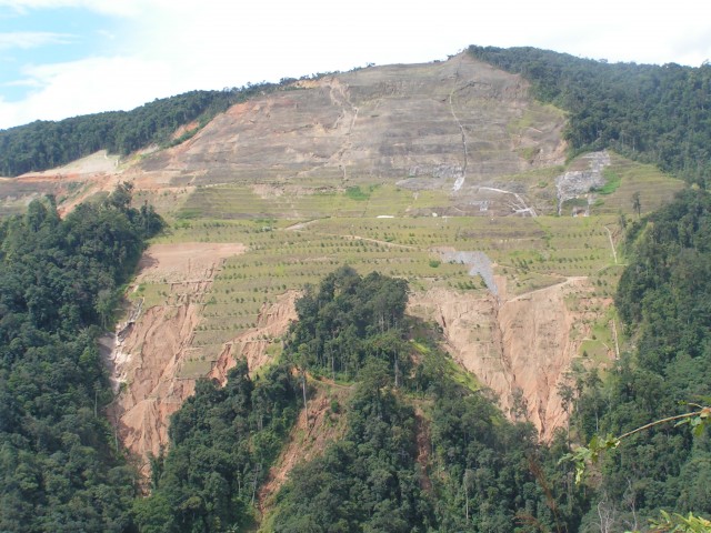
An example of hillslope preconditioning from Malaysia
.
A closer look shows the massive displacement on the shear surface and the damage to the rock mass that forms the landslide:
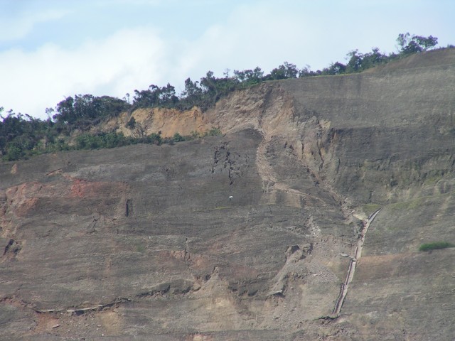
A closer view of the shear surface, showing hillslope preconditioning
.
These images were taken in 2006. The slope has yet to collapse.
Whilst hillslope preconditioning is a really interesting idea, there is little quantitative analysis to ascertain whether it is a real factor in slope behaviour. In a paper just published in Earth Surface Dynamics (Parker et al. 2015) – this is an open access paper, so you can download it for free – we have tried to explore this effect by looking at the effects of two earthquakes in New Zealand. These earthquakes occurred in 1929 – the so-called Buller Earthquake – and in 1968 – the Inangahua earthquake. Both triggered large numbers of landslides, which were subsequently mapped, primarily by my good friend Graham Hancox at GNS Science in New Zealand. The beautiful thing about these two events is that they occurred reasonably closely together (the epicentres were 21 km apart), such that there was an area that was affected by both earthquake events, as this image from the map shows:-
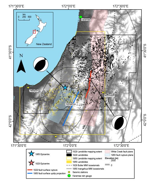
Map of the areas affected by the two earthquakes, illustrating the distribution of the mapped landslides. From Parker et al. (2015)
.
This work was led by my then PhD student Robert Parker, who hypothesised that if the hillslope preconditioning idea is correct then in this overlap zone it might be expected that the probability of landslides being triggered by the second – 1968 – earthquake would be higher than in the rest of the area affected by this seismic event. In other words, we think that the 1929 earthquake might have preconditioned the slopes in the overlap zone, making them more susceptible to failure. This should be characterised by an unexpectedly high occurrence of landslides in this zone compared with the remainder of the area affected by the 1968 earthquake.
The idea is simple, but investigating this hillslope preconditioning effect is actually very challenging. We had to use a complex statistical approach – I won’t describe it in detail here, but you can read about it in the paper. Essentially we had to model the effects of time independent factors – slope angle, lithology, etc – and then correct for these factors in the overlap zone. The analysis suggests that once these factors have been controlled the probability of failure in the overlap zone is higher than would be expected, suggesting that another factor – hillslope preconditioning – is having an influence.
In the paper we emphasise that these results are tentative, and that more work is needed. In particular, the dynamics of the interactions between slopes and seismic waves are so complex that it could be that there is another factor, for which we have not controlled, having an influence. Indeed it could be that the results are just random effects. However, the result does seem to be robust and fits with our understanding of slope behaviour.
If this result is correct then it potentially makes the analysis of the potential for slope failure in a future earthquake even more difficult. On the other hand, it might also open up new possibilities for analysing slope response to seismic events, as well as changing the way that we conceptualise the development of failure.
Reference
Parker, R.N,., Hancox, G.T., Petley, D.N., Massey, C.I., Densmore, A.L., Rosser, N.J. 2015. Spatial distributions of earthquake-induced landslides and hillslope preconditioning in the northwest South Island, New Zealand. Earth Surface Dynamics, 3 (4), 501-525.
2 November 2015
A roundup of new landslide videos
Via the Daily Mail
.
New landslide videos
In the last couple of weeks some new landslide videos have appeared:
A huge rockslide in Taxila, Pakistan
This one is pretty spectacular, although I have very little information about it:
.
I would be interested in more information. I don’t think I’ve seen it before, but am unsure. It is truly spectacular!
.
A rockslide in Mexico
This one was covered quite extensively in the media:
.
The Daily Mail reported it as follows:
At least 15 cars were damaged as six thousand cubic metres of earth crashed onto the road below. Amazingly, the landslide did not bring down two tower blocks and a private house built precariously near the cliff edge as the ground collapsed underneath them. But shocked drivers and pedestrians below meanwhile tried to flee the debris, and the huge dust cloud that followed. The dramatic incident happened in Santa Fe, one of the major business districts of Mexico City, located in the west part of the Mexican capital city. Parts of the video were taken from the other side of the valley, on dashboard cameras and mobile phones, and they were all uploaded onto social media where they quickly went viral. Officials say people living in the apartment buildings were told there was a risk of landslide back in 2007, but ignored their warnings. The authorities of Cuajimalpa, one of the 16 boroughs of Mexico City to which Santa Fe belongs, also said they had previously advised the inhabitants to abandon the buildings fearing they would fall if there was a landslide.
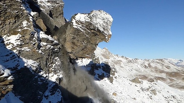
A rock topple in Switzerland
This pair of landslide videos showing a spectacular rock topple in Switzerland was also extensively covered:
.
The Daily Mail reported this one too:
This is the incredible moment a huge piece of rock broke free from the side of a mountain and plummeted 1,000 feet in Switzerland. The incredible footage was captured by a geologist who just happened to be filming when the rock fall occurred on a mountain in the Swiss Alps. According to local reports the 2,000 cubic metres of solid rock that fell caused an avalanche on the mountain of Mel de la Niva, near Evolene. Geologists studying the mountain had noted geological activity prior to the incident and the site had been under surveillance since 2013, reported Le Nouvelliste. Major movements were detected last week and the hamlet of Arbey and a road below the mountain had been evacuated and shut the day before.
30 October 2015
The Big Horn Mountains landslide in Wyoming
The Big Horn Mountains landslide
There is quite a lot of interest in the media in a landslide that has developed in the last fortnight in the Big Horn Mountains of Wyoming. This was first reported by SNS Outfitter and Guides on their Facebook site, with the following impressive picture:-
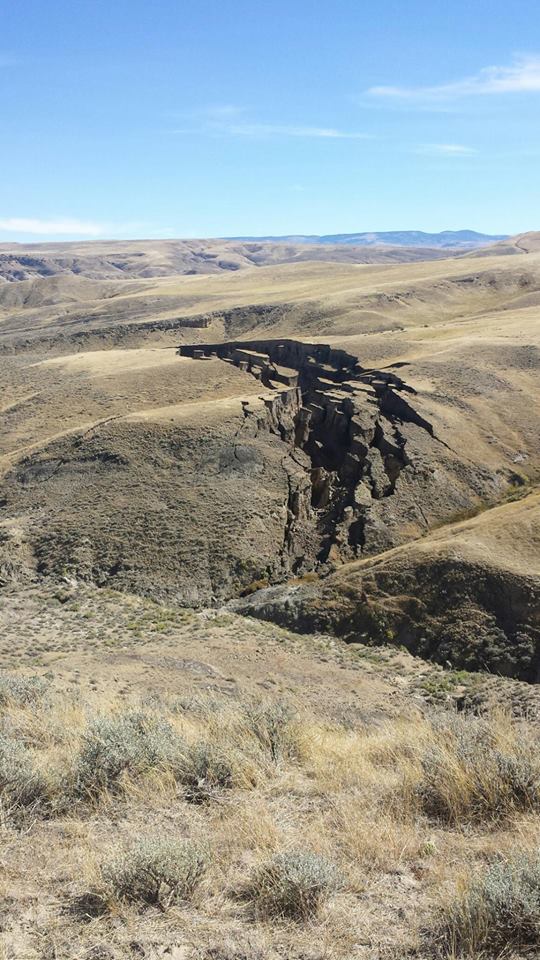
Big Horn Mountains landslide from SNS Outfitter and Guides
.
The caption was:
This giant crack in the earth appeared in the last two weeks on a ranch we hunt in the Bighorn Mountains. Everyone here is calling it “the gash”. It’s a really incredible sight.
A couple of days later they followed this up with a further image:-
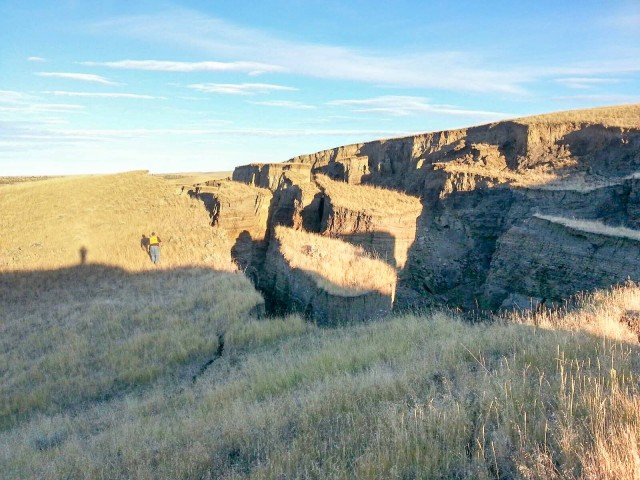
Big Horn Mountains landslide courtesy of SNS Outfitter and Guides
.
The caption this time was:
Since so many people have commented and asked questions, we wanted to post an update with a little more information. An engineer from Riverton, WY came out to shed a little light on this giant crack in the earth. Apparently, a wet spring lubricated across a cap rock. Then, a small spring on either side caused the bottom to slide out. He estimated 15 to 20 million yards of movement. By range finder, an estimate is 750 yards long and about 50 yards wide.
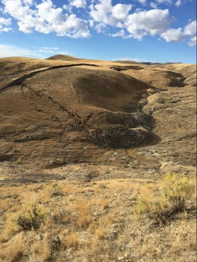
The Big Horn Mountain landslide via sott.net
29 October 2015
The amazing Tonzang landslides in Burma – NASA images
Tonzang landslide event in Burma
In late July and early August extreme rainfall in the Tonzang area of Burma triggered extensive landslides and floods. Whilst there were some media reports of these events (and a good blog site has reported upon them), and a few weeks ago I posted some images, details of this event have remained sketchy. This event has been particularly intriguing as Goran Ekstrom and Colin Stark from Columbia University picked up two landslide seismic events, and of course these are only generated by the largest landslides. Unfortunately the summer is monsoonal in Burma, meaning that it has not been possible until now to obtain good quality satellite imagery. In the last few days NASA kindly tasked the EO-1 satellite to image the area, and Colin has equally kindly provided some images and information.
What is now clear is that this was a most unusual landslide event. The satellite image below shows and overview of the landslides triggered by the rainfall. Note that this image does not cover the entire area, so there are more landslides to be found as yet. The brown areas in the mountains are the multiple landslides triggered by the rainfall – note just how many there are:-
NASA EO-1 image of the Tonzang landslides. Courtesy of NASA and Colin Stark
.
I have posted before on the largest of the landslides, which is clearly visible in the image above, based upon the UNOSAT mapping of a part of the slide. We now have decent imagery of this event – and it is truly enormous:-
The largest of the Tonzang landslides, from the NASA EO-1 image. Courtesy of NASA and Colin Stark
.
It is hard to get a scale on this from the image, but from the crown of the failure to the toe it is 5.9 km. This is a genuinely remarkable event – without doubt one of the largest rainfall induced landslides in recent years. It is clear that the landslide has blocked the valley and a lake has developed upstream, although this is not very large. Note the many other landslides visible on the image, also triggered by this rainfall event. These are very diverse, including channelised debris flows and translational failures.
However, the two seismic events that Goran Ekstrom detected do not appear to correspond to this landslide. These are the two velocity / trajectory graphs for those two slides, generated through the inversion of the seismic data:-
Velocity – trajectory graph for one of the Tonzang landslides, courtesy of Colin Stark and Goran Ekstrom
.

Velocity – trajectory graph for the second of the Tonzang landslides, courtesy of Colin Stark and Goran Ekstrom
.
These are both large landslides, but neither the trajectory nor the runout distance correspond to the large event shown above. The only potential candidates on the imagery lie in this area of landslides to the south of the largest event:-
NASA EO-1 image of the second largest of the Tonzang landslides, courtesy of NASA and Colin Stark
.
It is not clear to me that these landslides are the correct candidates, which may mean that there are further large landslides that have yet to be captured on the satellite imagery. There is clearly more work to be done, and it will be very interesting to see what emerges when the rest of the area is captured on satellite imagery in the coming weeks.
Acknowledgement
Many thanks to Colin Stark and Goran Ekstrom and Columbia University and Stuart Frye at NASA for their help with this post.
 Dave Petley is the Vice-Chancellor of the University of Hull in the United Kingdom. His blog provides commentary and analysis of landslide events occurring worldwide, including the landslides themselves, latest research, and conferences and meetings.
Recent Comments