12 May 2012
More information on the landslide that caused the Seti Flood in Nepal
Posted by Dave Petley
Over the last few days Colin Stark and I have spent some time trying to determine the nature of the landslide that was responsible for the catastrophic flood on the Seti River, close to Pokhara in Nepal, which killed 72 people. We are trying to tie together the amazing data from the seismic network with observations and timings. The primary source of information has been the remarkable videos and photos collected by Captain Alexander Maximov of the Aviaclub Nepal, who was flying over the valley at the time. You will recall that Captain Maximov raised the alarm about the flood, which may have saved many lives. I must at this stage thank Captain Maximov and Aviaclub Nepal for both their prompt action and for their help – a mountain flight with them is definitely on my “to-do” list next time I am in Nepal!
The latest, genuinely remarkable, development is that Captain Maximov captured the landslide as it occurred on a video that he was shooting from the wing of the aircraft. He has posted the video on Youtube:
http://www.youtube.com/watch?v=Uk82ggshSKs
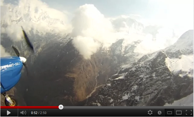
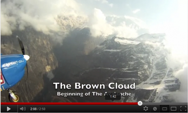
You will see that the aircraft was flying orbits to allow sightseeing. On the first orbit the slope was apparently stable, in the second it was in full collapse mode, generating huge amounts of dust. Note the lack of an obvious triggering process (clear weather, no seismicity). These two frames from the film arereally interesting. This is from the first orbit, showing the site of the landslide:
And here is one from the second orbit with the landslide in full motion:
The two images are only 1 minute and 16 seconds apart, but the failure is apparently stable in the first and full developed in the second. This is consistent with the observations from the seismic data of course, which indicates that the entire event took less than two minutes.
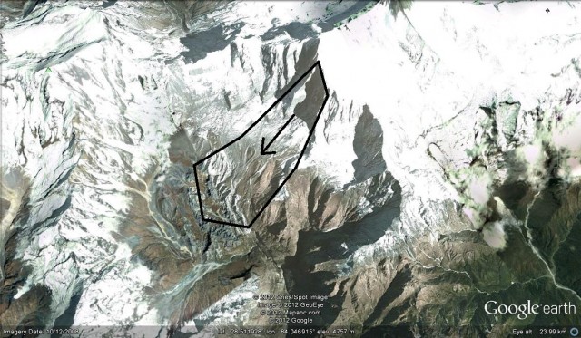
Colin has worked very hard to use the video to determine the location of the landslide. The best estimate is that is was here (this is my interpretation of Colin Stark‘s great work on this, please treat is as very speculative):
This is the flank of the mountain known as Annapurna IV.
The flood event itself was very destructive. If you have not seen in it, this video shows the wave passing downstream:
www.youtube.com/watch?v=3W0HbJRN8JE
The mechanism through which the wave was generated remains unclear. To my mind the initial assumption that it was a landslide dam break flood seems in question given the location of the landslide. I wonder if the slide caused extensive melting of glacial ice in the valley? Alternative possibilities are the transition to a debris flow of the landslide mass itself, which then entrained extensively downslope, or the mobilisation of sediments in the valley.
I would be very grateful for comments and thoughts on this. Needless to say, satellite imagery of the landslide deposit would be absolutely invaluable.


 Dave Petley is the Vice-Chancellor of the University of Hull in the United Kingdom. His blog provides commentary and analysis of landslide events occurring worldwide, including the landslides themselves, latest research, and conferences and meetings.
Dear Colin,
Thank you for this important information. I think you have assessed from a number of aspects. However while looking at the Brown Cloud that originates from the fall of ice with earth particles, in my feeling the site should be on the slope of Annapurna III. If you look into the google maps (280 34’ 2.44”N and 850 00’ 20.17” E), there were already some signs of soil / earth movements. I think this mass might have moved down.
Regards
Gehendra B. Gurung
Great article, thanks a lot! I always enjoy reading the latest landslide news here. Check out this amazing video on a rockslide in the swiss alps from CNN: http://edition.cnn.com/video/?/video/world/2012/05/17/vo-swiss-landslide.swiss-broadcasting
Hey Dave, Hope your weekend is going well. Regardless of the spam issue, really am enjoying reading your blog!
– Kerry
[…] pilot—who was flying a sightseeing tour over the region when the landslide occurred—has shared video of the dust cloud, which probably formed in a matter of minutes after the slide started. He also acquired aerial […]
[…] Nepal observed a thick dark cloud emerging below the Annapurna mountains and captured it on a video camera mounted on the wing of his aircraft. Realising the danger, he radioed a warning to officials at Pokhara airport. His quick response […]
[…] many ways this event feels similar to the 2012 Seti River flood in Nepal. This was triggered by a giant rockslope failure from the Annapurna massif, which transitioned into a catastrophic […]