20 May 2019
The Joffre Peak rock avalanches: new images
Posted by Dave Petley
The Joffre Peak rock avalanches: new images
It is now clear that the second Joffre Peak rock avalanche last week was indeed larger by volume than the first. Images suggest that the release surface was probably an extension of the one that allowed the first landslide to occur.
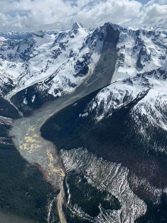
Yesterday, Lindsey Nicholson tweeted a wonderful image, taken by Wilfied Braun, showing the full extent of the second landslide:-

The full track of the second of the Joffre Peak rock avalanches in Canad. Image tweeted by Lindsey Nicholson, via Geomorphology rules on Facebook. Image by Wilfried Braun.
.
The larger landslide source area is evident on Joffre Peak itself, and the full, chaotic, muddy track is also clear. Interestingly there does not appear to be much super-elevation on the bend, but field work will be needed to determine this for sure.
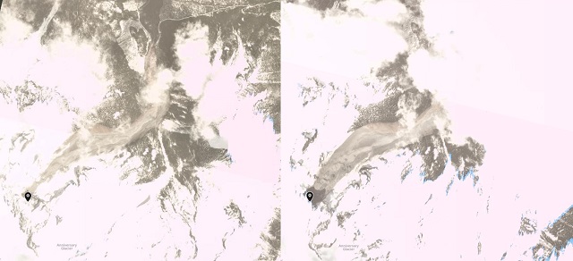
Collecting good satellite imagery of the landslide in an area with so much cloud is difficult. Simon Gascoin tweeted a Landsat 8 image of the first of the two Joffre Peak rock avalanches. Planet Labs have captured two images of the landslides, but unfortunately neither show the full track at this point. However, they do capture the upper portion of the tracks of the two rock avalanches, allowing the scale of the two to be compared:-

Planet Labs imagery of the Joffre Peak rock avalanches. Left hand image, PlanetScope collected 15th May 2019, right hand image PlanetScope collected 18th May. Images copyright Planet Labs, used with permission.
.
The very much larger scale of the second event, with its much broader track, is clear.
Meanwhile, there is some speculation that a further failure event is possible at Joffre Peak, given that the release surface appears to define another large rock block (see the image here to see the block that might detach). A collapse is not inevitable, but this would be a great monitoring project.
Reference
Planet Team (2019). Planet Application Program Interface: In Space for Life on Earth. San Francisco, CA.


 Dave Petley is the Vice-Chancellor of the University of Hull in the United Kingdom. His blog provides commentary and analysis of landslide events occurring worldwide, including the landslides themselves, latest research, and conferences and meetings.
These Planet Labs images make a nice stereopair, FWIW
An interesting side note to these events is that both slides overtopped a nicely developed Little Ice Age moraine formed near the bottom of the slope below the release points, yet the moraine appears to remain largely intact. Suggests that the slides were not scouring much (bulking up) by the time they hit the moraine. The fact that the moraine shape is still visible also indicates that the slide debris is quite thin at that location. I’ll be interesting to see how thick the deposit is further down valley.
Doug Clark,
Regarding the moraine. There is a picture in this album from a 2013 hike that shows the moraine from where the Cerise Creek Summer Trail crossed the avalanche path: https://cliffj.smugmug.com/Sports/Hiking/Nanaimo-Hikers/2013-Joffre-Cerise-hikes/i-KQRQ2p6/A
Dear Mr Petley,
I released this story about Joffre Peak rock avalanches quoting some of your work on this blog: https://www.sentinelvision.eu/gallery/html/73bff023a3a04b2eb9c88eca8c749e28
It features 3D views of
– orthorectified Sentinel-1 radar images (before / in-between / after the two avalanches), 2 series using 2 of the 4 viewing geometries available.
– a pair of Sentinel-2 cloudless images (before / after) using much more contrasted VNIR+SWIR composites in BOA reflectance.
By clicking the hyperlinks you can browse anywhere in the images up to full resolution.
I suppose this can be useful to you.