22 March 2018
Wairoa: a significant valley-blocking landslide in New Zealand
Posted by Dave Petley
Wairoa: a significant valley-blocking landslide in New Zealand
A significant valley-blocking landslide has occurred on a tributary of the Wairoa River, to the west of Gisborne, in the North Island of New Zealand. The landslide is large – Radio New Zealand reports about 80 million tonnes (presumably about 30 million m³) [see the comment at the bottom of the article – this is more likely to be about 8 million tonnes], and Google Earth indicates that it is over 1 km long. The Mangapoike River, the specific tributary of the Wairoa Rver, is blocked. The impounded lake is currently about 50 m deep and is rising at 60 cm per day. There is a significant risk of a breach, but fortunately this is a sparsely populated area of New Zealand. Reports suggest that it was triggered by a localised earthquake earlier in March 2018.
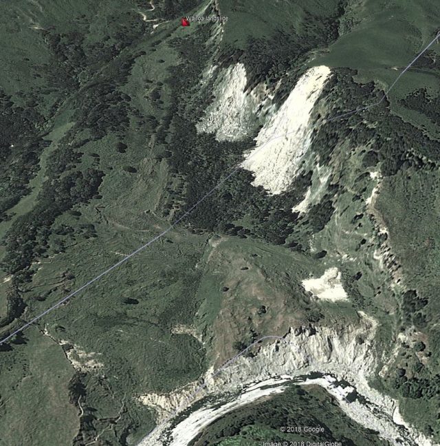
This is the site of the landslide on Google Earth. I have placed the market at the approximate crown of the landslide. The image was collected in early 2011:-

Google Earth image of the site of the Wairoa River landslide in New Zealand.
.
This image shows that this was a pre-existing landslide that has been creeping. Lateral scarps are evident on both flanks, and the area on the left of the landslide shows clear evidence of tension cracks. It appears that there was active erosion occurring at the toe of the slope.
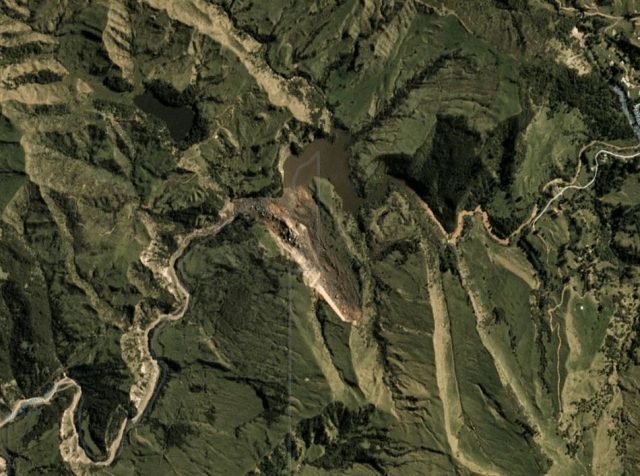
This is a Planet Labs image of the landslide, collected on 12th March 2018 and used with permission:-

Planet Labs image, collected on 12th March 2018, showing the landslide on the Mangapoike River near to Wairoa in New Zealand.
.
The image clearly shows the landslide scar and the deposit at the toe that has blocked the river. The lake is also clearly evident. Note that at present this is not large in terms of extent, but it has the potential to generate a significant flood event. Fortunately New Zealand has very considerable experience in dealing with these types of events.
Reference
Planet Team (2017). Planet Application Program Interface: In Space for Life on Earth. San Francisco, CA. https://api.planet.com


 Dave Petley is the Vice-Chancellor of the University of Hull in the United Kingdom. His blog provides commentary and analysis of landslide events occurring worldwide, including the landslides themselves, latest research, and conferences and meetings.
Fantastic articles Dave. When you are presenting before and after photos, is it possible to stick a quick “reference mark” on each image? Sometimes I have trouble putting the images (usually from two different sources/resolutions/etc) together in my brain. Yes, it’s my deficiency, but I’m sure others as well! Just a thought.
Thanks for all you do.
[Many thanks, and yes that is a very sensible suggestion. D.]
Just a point. You first image is not the site of the landslide and the 80mt is wrong, the rock slide is around 8MT and the total mass around 11.5m, excluding what was lost into the river below as a debris flow.
[I am surprised by your first comment. I have rechecked – it looks like the correct location to me. Your volumes sound more likely. D.]
This is a very interesting new development by nasa , don’t you think ?
https://www.nasa.gov/feature/goddard/2018/new-from-nasa-tracking-landslide-hazards-new-nasa-model-finds-landslide-threats-in-near-real
based on Planet.com imagery, it looks like the slide occurred between Feb 20 and 24, not in March. not sure if that would agree with the March earthquake trigger that the Civil Defense Manager suggest in the Stuff report (https://www.stuff.co.nz/environment/102499230/huge-slip-between-wairoa-and-gisborne-creates-large-lake-and-significant-hazard)
Here’s a news paper report about this landslide and there’s to be a TV feature on it within the next week https://i.stuff.co.nz/environment/105413362/hillside-collapses-to-form-new-zealands-newest-lake