29 November 2022
Cianjur: a deadly landslide from the 21 November 2022 West Java earthquake
Posted by Dave Petley
Cianjur: a deadly landslide from the 21 November 2022 West Java earthquake
On 21 November 2022, a Mw=5.6 earthquake struck West Java in Indonesia. The magnitude of the earthquake was comparatively low, but the event was exceptionally shallow (≈11 km), generating very high peak ground accelerations, albeit over a small but populated area. At the time of writing it is estimated that at least 323 people were killed and over 62,000 homes were damaged.
In this environment. damaging earthquakes would be expected to trigger landslides. Wikipiedia reports damage to roads and power infrastructure:
Landslides cut off roads.[28] A landslide along Puncak-Cipanas-Cianjur national road forced a traffic diversion. Toppled trees, uprooted power poles and downed power cables also occurred along roads.[29] The Ministry of Energy and Mineral Resources said two landslides occurred in Cugenang District. One measured 44 m (144 ft) and 16 m (52 ft) high while the latter measured 162 m (531 ft) and 45 m (148 ft) high.[30] A village in Cugenang with eight homes was completely buried under a landslide.[31]
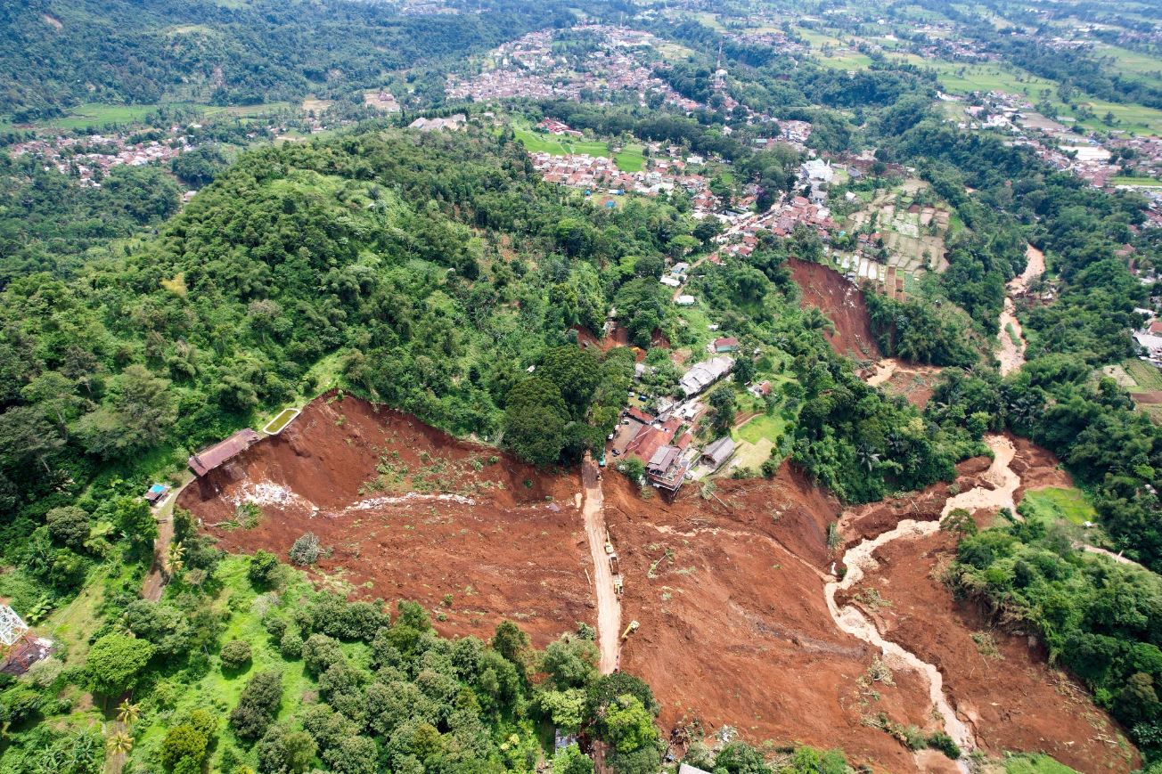
The most spectacular landslide that I have seen occurred close to Cugenang, as noted above. There are images of this landslide in a Tweet by GMA News, featuring images by Antara Foto/Raisan Al Farisi via Reuters:-
https://twitter.com/gmanews/status/1595347805232836609
.
The second image is very revealing:-

Landslides close to Cugenang, triggered by the 2022 West Java earthquake. Image tweeted by GMA News, by Antara Foto/Raisan Al Farisi via Reuters.
.
The location of the main landslide is -6.795, 107.079. The image shows two other landslides, one just above the road on the far side of the main failure (also visible in the first image tweeted by GMA News), and the other on a bend in the river. The material forming the landslides is deeply weathered and the failure at the head scarp is quite deep. It is interesting that the crown of the landslide coincides with some buildings and a terrace.
It is not clear at present as to the number of other landslides that have been triggered by this earthquake, and clouds make satellite imagery hard to collect. Some reports indicate that 18 bodies were recovered from a landslide, but I am unsure as to the particular failure to which this refers.


 Dave Petley is the Vice-Chancellor of the University of Hull in the United Kingdom. His blog provides commentary and analysis of landslide events occurring worldwide, including the landslides themselves, latest research, and conferences and meetings.
The head of the main failure makes me wonder about surface drainage: hardscape shedding water onto loose fill and it blowing out. I saw this many places along logging roads on the north coast of California during the El Niño years of the mid-90’s. There also is a lot of hardscape (roofs) above the smaller slide. It often seemed that these El Niño sites were just barely hanging on (FS=1.01) and all it took was a little extra “something” to push them over the instability threshold.
Yo tengo la Flex ❣️❣️