25 March 2021
Wongawallan: a damaging landslide in Australia
Posted by Dave Petley
Wongawallan: a damaging landslide in Australia
The eastern side of Australia has suffered devastating rains over the last few days, causing extensive flooding. There have been a number of landslides too, of which the most spectacular may be the one at Wongawallan in the Gold Coast hinterland in Queensland. This landslide appears to have affected the grounds of a very beautiful house. The image below, from Reddit, shows the site before the landslide:-

The site of the Wongawallan landslide. Image via Reddit.
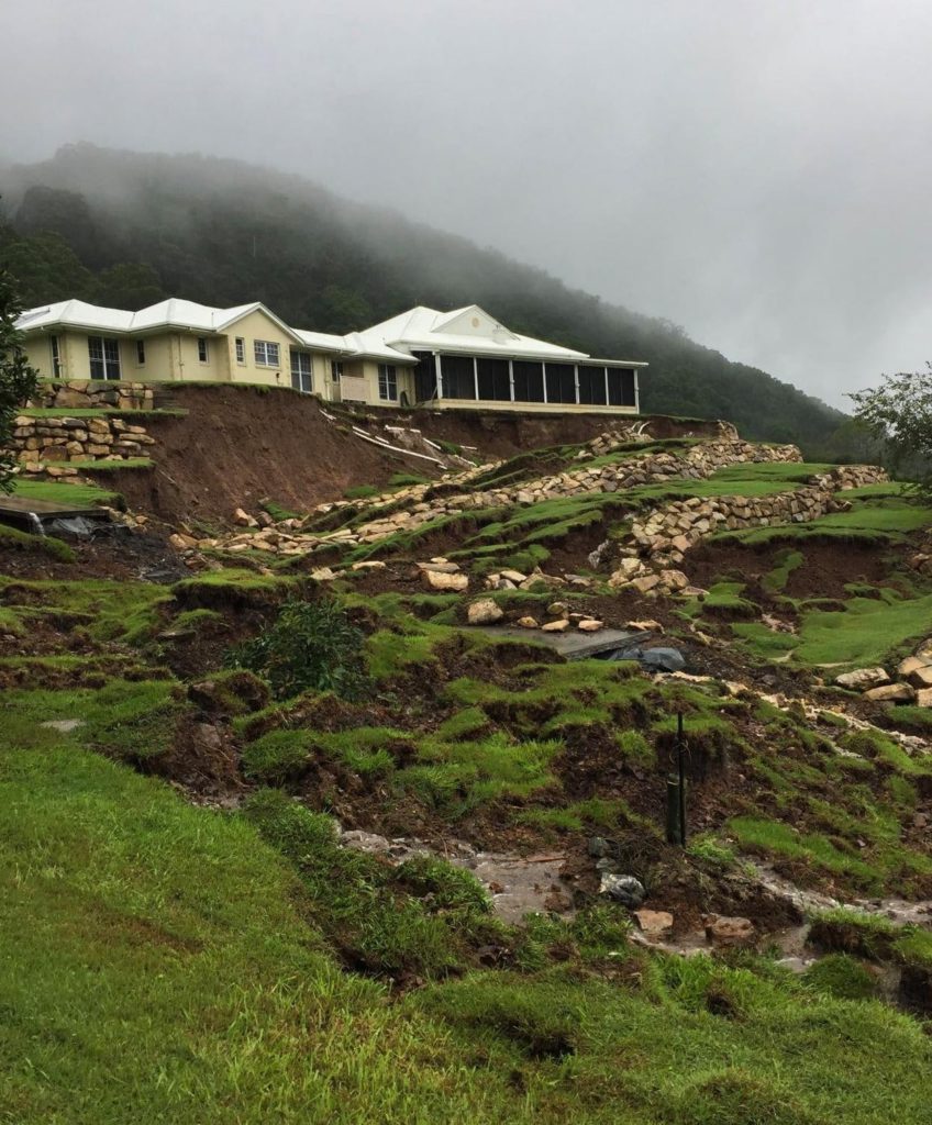
The image below shows the aftermath of the landslide, again the image is from Reddit:

The aftermath of the Wongawallan landslide in Australia. Image via Reddit.
.
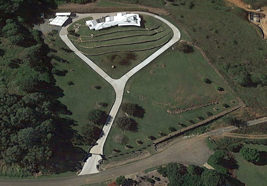
Clearly for the homeowner this is a disastrous landslide, causing enormous levels of damage. Looking at Google Earth, it appears that the property was constructed between 2004 and 2009. The mound upon which it is located appears to be made ground, initially without the terraces, which appear to have been under construction is an image in November 2013. I wonder why the slope was terraced at this later stage? The Google Earth images might provide a clue, but I do not wish to speculate. The location of the landslide is -27.880° 153.245°.
The image below shows the state of the terraced slope, and the adjacent slopes, in 2016:-

Google Earth image of the site of the Wongawallan landslide in Australia.
.
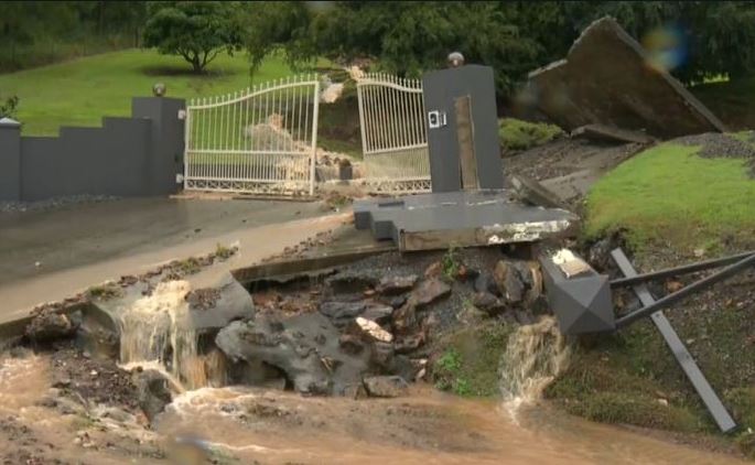
The obvious part of the failure is the section of terraced slope directly below the house, but the landslide appears to have extended all the way down to the gates, a distance of about 110 metres:-

The lower part of the slope failure at Wongawallan. Image via 9 News.
.
There are two obvious possible failure mechanisms here. It could be that the terraced mound has failed, loading the lower part of the slope, inducing failure lower down. An alternative is that the ground beneath the mound has failed, with the instability retrogressing though the mound. A proper site investigation is needed to ascertain the cause.
The impacts are unfortunately likely to be extremely expensive, and to be very disruptive for the owners of a beautiful property.


 Dave Petley is the Vice-Chancellor of the University of Hull in the United Kingdom. His blog provides commentary and analysis of landslide events occurring worldwide, including the landslides themselves, latest research, and conferences and meetings.
The google earth images suggests there was a first landslide just below the house during the year 2013. I presume the earthworks whith stone walls were made to mitigate the landslide problem… I also suspect that the slope that failed is the filling material of the cut slope behind the house, which has been first vegetalised (probably not compacted). Probably that part failed again due to heavy rainfall and lack of proper dimensioning of the “retaining” stone wall (often whtih lack of draining systems). This guy is going to need soil nailing soon. Good luck to all aussies there.
Looks to me like the hillock the house is built on might be landslide debris originating from the steep ground behind the house. If that’s the case, and if the slide is relatively recent, then that ground is unlikely to be well consolidated and has likely reactivated following saturation from the heavy rain. A good geotech investigation prior to building would have surely identified this risk. And I bet there isn’t a good diversion drainage system around the property to stop saturation of the house foundations from the upslope catchment.
Agree with Fabien Peyral concerning the 2013 failure, which may have started early in the year (march Google-Earth image). Sadly, it looks like our friends Down Under could use some competent geotechnical engineers and/or engineering geologists. By the way Dave, love your blog.
And as I often ask: Are you on septic or sewer? If septic, where is the leachfield?
I agree w/ the poorly compacted fill failure and and possible loading at the head of an old slide. the hillfront is hummocky and there appears to be an active earthflow complex approx 450m SSW along strike.
Looking at the style of construction and having worked in this area for some time it appears that the home owner has attempted to game the regulations that have been put in place to avoid the requirements for engineering review or design on the terraced slope. The site falls within the area where landslide risk assessments are required for all works, but that detailed engineering design is not required if changes in the land surface do not exceed more than 2m from natural at any point (this is not the total height but the height between the fill and the original surface at any point). The retaining wall would have been classified as a prescribed construction because the benches only retain 1m of soil and the benches are more than 1.5 times the height apart. This style of construction generally has no functional drainage and the quality of construction is entirely dependent on the capability of the bloke in the excavator. Further, in general experience the fill that the house is constructed on would likely be uncompacted, but the house will be on piers with concrete edge beams through the uncompacted fill, this would account for the apparent damage to the house despite the slip.
It would be interesting to know where the septic irrigation area would have been situated on the property (this area does not have reticulated sewerage, so waste water is disposed by a sprinkler system onto part of the slope). Also the stormwater disposal arrangement and the overflow for the two buried concrete tanks on the northern side of the house (house is not located in an area with town water). Also it appears that there are PVC stormwater pipes at the crest of the slip coming from both the north and south sides of the house which are broken and may have contributed to the slip.
The mechanism of failure is construction over a large historical landslide. It is a known and recognised landslide that where the recent failure has occurred is a very small part of. If you look at the local council slope stability maps it is zone very high susceptibility to landslides.
The same weather event resulted in a large number of small landslides on the North Coast of NSW, with many small roads and several arterial roads in the coastal hinterland likely to be blocked for several weeks while repairs are undertaken.
Some footage from one such road, the aptly named Waterfall Way, is in the following article.
https://www.macleayargus.com.au/story/7176096/drone-footage-of-landslide-that-closed-waterfall-way/?cs=483