3 January 2019
Anak Krakatau: Planet Labs imagery of the aftermath of the landslide
Posted by Dave Petley
Anak Krakatau: Planet Labs imagery of the aftermath of the landslide
Planet Labs has now captured a high-resolution SkySat image of the aftermath of the Anak Krakatau landslide, which generated the deadly tsunami shortly before Christmas. These images are featured on the BBC website too, with an excellent commentary from Jonathan Amos. The images are spectacular, as usual.
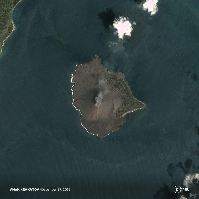
So, here is an image collected on 17th December 2018 showing the volcano shortly before the landslide. Note the smoking volcanic cone:-

Planet Labs image of Anak Krakatau prior to the landslide
.
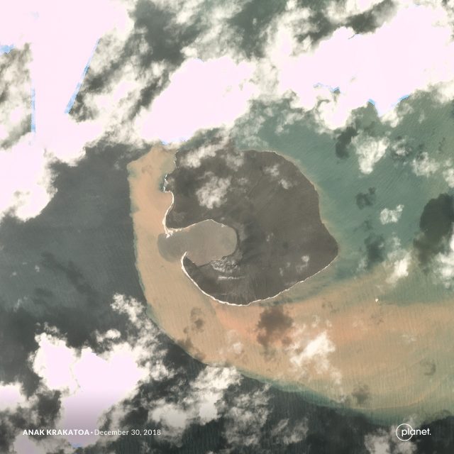
I can see no signs of any precursory deformation features on the volcano, which is perhaps a little surprising. The second image shows the volcano after the landslide, in an image captured on 30th December 2018:-

Planet Labs image showing Anak Krakatau after the landslide. Image captured 30th December 2018.
.
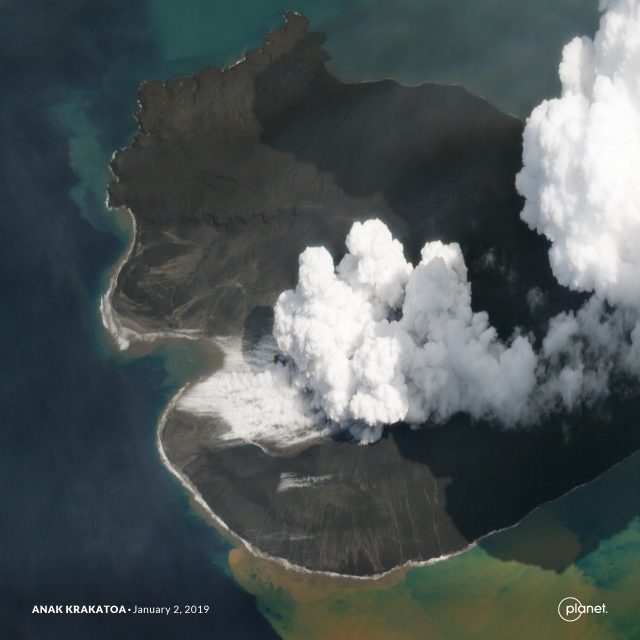
This image shows the bowl-shaped landslide scar, and the new, small, bay formed by the collapse. There is a huge amount of sediment in the water around Anak Krakatau. The final image was captured using the SkySat high resolution instrument, providing the best image yet of the aftermath of the landslide:-

Planet Labs SkySat image of the aftermath of the Anak Krakatau landslide in Indonesia. Image captured on 2nd January 2019.
.
So what can we say about the landslide on Anak Krakatau? To me the scar appears to have a bowl shape, suggesting a complex (multi-phase?), possibly rotational (?) slip. However, the toe of the landslide was extremely broad (look at the alignment of the rear scarp on the far side of the scar), meaning that the slide would have been able to displace water across a very large front. Whilst early reports of the landslide were that it was probably submarine, the images are clear that a very large part of it (possibly the largest part) was subaerial (i.e. occurred above sea level). No remains of the landslide are seen – it left almost nothing behind as far as I can see – so the entire volume of 150-170 million cubic metres entered the water. It is unsurprising therefore that it generated a very significant tsunami in the local area.
An interesting aspect is the peninsular left on the southern (nearest) part of the bay, seen in the second image of Anak Krakatau. This is an unusual feature for a landslide scar. Compare the before and after images – is the peninsular composed of harder volcanic rock (lava flow?) rather than the looser cone deposits? So, in this area did the landslide occur primarily in the looser deposits? Or did this peninsular form in the volcanic eruptions immediately after the landslide? Some of the radar imagery might suggest that this is the case?
Comments please from those who know volcanoes well.
Reference
Planet Team (2018). Planet Application Program Interface: In Space for Life on Earth. San Francisco, CA. https://www.planet.com/.


 Dave Petley is the Vice-Chancellor of the University of Hull in the United Kingdom. His blog provides commentary and analysis of landslide events occurring worldwide, including the landslides themselves, latest research, and conferences and meetings.
Hi Dave,
I found a geologic map of the volcano showing that the collapsing part was mostly from the 1970’s materials whereas the remaining parts are from the 90’s (https://www.instagram.com/p/Br6l6IqAf8C/), and it fits pretty much the landslide scare ! The 70’s material could have been made of coarse-grained deposits due to a phreato-magmatic (as we see today) or pyroclastic behavior, forming loose deposits with a inclined bedding toward the sea… the 90’s deposits look more like hard lava flows. I also note on this picture (https://www.instagram.com/p/Br2M609gpoi/) the great amount of deposits mostly on the West flank (I guess) of the volcano during the june-october 2018 eruption… Last, on the video provided here (https://www.youtube.com/watch?time_continue=3&v=MTQmwpWOxnk) taken hours before the landslide, you can see big smoke clouds emerging from the sea… some are telling it’s lava flows entering the see, to me the cloud comes far from the shore… could have it been a side vent borning undersea, triggering the landslide? those are just hypothesis… As usual thanks for the updates…
Hi Dave,
looking on the 30.12.2018 image in your blog I would suggest that the primary phase of the collapse occurred under sea and the on-shore landslide represent secondary movement leaving the curious peninsula on the edge of the bay as a result of the sub-vertical movement of the on-shore part (I would expect sub-vertical discontinuities/weakened planes in the central part of the volcano where the scarp ends). The peninsula seems to be absent on the 2.1.2019 image suggesting its very unstable state. GoogleEarth archive images suggest that the collapsed part was the most steep section of the cone (20.9.2015) resulting from material accumulation (loading). 4.7.2008 and 12.7.2010 images show two temporary “collapse” craters formed on the same slope (unloading events?) suggesting that this part may be susceptible to such events – one similar or larger crater could form off-shore as suggests the youtube video posted by Fabien.
Dave, thank you for your post, it is very interesting event – I did not expect that we would need to update our database of giant landslides from volcanic islands that frequently and I hope that someone will soon map the off-shore part of this landslide.
Jan
Two comments (from a non-volcanologist):
1. The Dec 30 image shows no plume of steam, suggesting enough mass movement that the vent was covered by a lot of colder rock–which by Jan 2 had been heated to create a large area of boiling water.
2. In that image the E shore is more rounded and the plant cover seems to be gone, so there was some mass movement in all directions. Actually the whole shoreline looks rounded–no wave erosion yet?
I may be barking up the wrong tree here, but there seems to be a consistent fine sediment source on the south side of the island (assuming north is “up”). From a fluvial perspective, something appears to be keeping the seafloor there stirred up (There is also a fumarole field near there in the two post-eruption photos). Typically, things will settle down and water will clear up as fine sediments are winnowed from the surface, forming a resistant rocky “pavement” that is in equilibrium w/its surroundings.
Also, The middle photo shows clearer water displacing sediment-laden water away from the interior of the slide scar. This is most likely in response to tidal fluctuations. Either that, or the seafloor is moving in response to magma chamber fluctuations.
Got to assume that all the new land is due to the violent Surtseyan eruptions that followed the landslide.
I can’t imagine a perfect arc would form after.
Something underneath water near that area got hollow over time and top caved into it.
Must be pretty pyroplastic
Hello,
First of all thank you very much for all these very interesting and detailed articles.
I’m not sure the image of the 30th December can be directly interpreted to derive the scar of the landslide. It was taken a few days after the collapse, and thus after the intense surtseyan volcanic activity that followed the landslide. This activity had a significant impact on the shoreline by partially filling the scar of the collapse, and expanding the island to the North and East.
here are some radar images showing the evolution of the Island :
1)https://pbs.twimg.com/media/DvgtWdPUUAUGQVJ.jpg
2)https://pbs.twimg.com/media/Dv5VWgnU8AAEvoQ.jpg
3)https://pbs.twimg.com/media/DvfRcgnVsAIaXM0.jpg:large
4)https://uca9c5bd5967b5602dfa0d327e3f.dl.dropboxusercontent.com/cd/0/inline/AYtt1KUozmq7eXpTusfMC8Wx02tiC89idI6ftJ2NlOdggEbygfwsKc1a5UjpvyHGZMEwHG3UXq8Iz4BfWGLLmmAr2d7ir9kVhx6BBhOQiU7PfSRMQ_IXWOSMfCLVTvpe78LloZgzMjfv8DKQv2Ka0WlwvRNLtSJkuHA_l-NRstuC267F4DeH8e-Zxty-QDwXqlw/file
It is however difficult to interpret these images. Links 2 and 3, based on the radar image of 23/12, derive a relative small collapse scar. In link n°4, with the radar data from 25/12, a much larger collapse area is deduced.
So I find it hard to draw any firm conclusion. What is certain however is that the material erupted after the collapse should not be dismissed when analyzing satellite images.
Regards,
Marc
Where is a scale?
@#6 Patrick – Aside from the ‘pyroclastic’ reference, I agree. A significant (partially evacuated) magma chamber or throat collapse may have contributed to the resulting surface morphology as much as a classic landslide slip signified in the scalloped failure boundary higher up on the cone which completely encompassed the previous summit crater.
Mentioned on BBC TV news that a new sonar survey around Anak Krakatoa has found the sea-bed littered with great blocks of debris from the recent collapse. 70~~90 metres range was quoted.
IMHO, their on-line report is quite good.
https://www.bbc.co.uk/news/science-environment-50798253