8 October 2018
The Palu landslides – the worst landslide disaster in five years?
Posted by Dave Petley
The Palu landslides – the worst landslide disaster in five years?
It is becoming increasingly clear that the lass of life from the three Palu landslides, triggered by the earthquake in Sulawesi, is very high. In particular, the two landslides that struck main parts of the town, at Balaroa and Petobo, are thought to have exacted a terrible toll. A spokesman from Indonesia’s disaster agency, Sutopo Purwo Nugroho, was quoted thus on Sunday:-
“Based on reports from the (village) heads of Balaroa and Petobo, there are about 5,000 people who have not been found. Nevertheless, officials there are still trying to confirm this and are gathering data. It is not easy to obtain the exact number of those trapped by landslides, or liquefaction, or mud.”
Given the scale of the Palu landslides, and the very high number of houses involved, this level of loss is entirely possible. It is clear from the videos that the flow was highly mobile, which will have made escape from the crush of houses and debris extremely challenging, especially in a dense network of streets. The mobility of the debris will have meant that buildings will have filled with mud, even where there were voids that might have protected a person. It is therefore unsurprising that no survivors have now been recovered in a week. This AFP video shows the magnitude of the damage:-
.
The search for the missing will continue until Thursday; after that it is likely that the landslide sites will need to be classified as mass graves.
I suspect that this will be the highest loss in a landslide event since the 2013 Kedarnath debris flow. It will be the worst earthquake-induced landslide event since the 2008 Wenchuan earthquake.
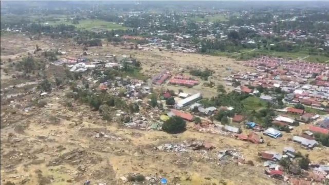
There is considerable confusion in the reporting as to what actually happened at Balaroa and Petobo. This is Petobo, as seen from the air:-

The aftermath of one of the Palu landslides, in this case the slide at Petobo. Image from Detik News
.
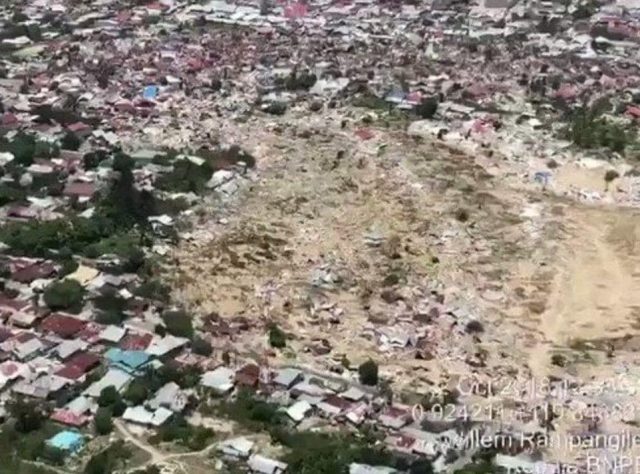
Whilst this is Balaroa:-

The Palu landslides: the aftermath of the Balaroa landslide. Image via The Daily Telegraph.
.
Various newspaper articles have described these events as being liquefaction, even nonsense such as:
“Petobo, a cluster of villages in Palu, was virtually wiped out by the powerful quake and wall of water that devastated Palu. Much of it was sucked whole into the ground as the vibrations from the quake turned soil to quicksand.”
In both cases these were landslides, of that there is no doubt. The mechanism of failure might have been liquefaction, but this is just a hypothesis. The houses were not sucked into the ground, they were buried and crushed by a flow of debris coming from upslope, albeit down a very low gradient slope. Whilst this might seem academic, it is important in the context of understanding future hazards.
To understand why these slopes flowed under the effects of earthquake shaking will require detailed investigations, in due course, using field data collection, lab testing and modelling. But seismically induced flowslides are not a new phenomenon by any means, and in previous events they have caused huge numbers of fatalities.


 Dave Petley is the Vice-Chancellor of the University of Hull in the United Kingdom. His blog provides commentary and analysis of landslide events occurring worldwide, including the landslides themselves, latest research, and conferences and meetings.
Thank you Dr Petley. Very intriguing indeed.
An interesting and new report on the events of Palu. But I’m confused.
What actually happened to cause the damage in Palu?
Yes there was an earthquake and the public news sources reported a tsunami. But I heard estimates of the wave crest height from 3 to 10m. What height was it? I imagine it could be quite high because Palu is at the end of a long narrow bay, so tides, etc. would be amplified like in the Bay of Fundy. Yet a topographic map of Palu shows only a limited area of the town is below even 10m. What area was damaged by the tsunami?
Now, this report of landslides triggered by the earthquake. Where exactly were these in the city?
Finally, what areas in the standard news reports were damaged by the tsunami and what actually by the landslides? The public reporting seemed to confuse the two.
Thanks for any clarity on this disaster.
Videos with links here have led me to believe that liquefaction contributed to the effects we are looking at.
I have often found myself reading inadequate news reports to try to get clarity on questions such as those posed above (B. Latham’s post). It is often the case that these kinds of first-order questions remain jumbled. It says to me is that more people with natural science backgrounds need to become journalists and they need to work closely with the photographers to clarify these issues. Maps (even sketches) are clearly in order. I had at one point great hope that the gps aided camera would help but I have yet to see that come to pass. My guess is that in on the order of a month or so a clarifying technical report will emerge. The underlying reason is that people probably have their hands full in the response phase. I am sympathetic to that and urge patience.
Very much in agreeance. Liquefaction was an apparent factor in most closely viewed videos…Houses may not have been “literally sucked into the earth”, but the rippling, smooth flow of the debris alone, speaks “liquefaction” in some form and of some degree.
Thank you for making this, you helped me on my school assignment 🙂