
13 April 2016
Landslide damage to the Karakoram Highway
Posted by Dave Petley
Landslide damage to the Karakoram Highway
The Pamir Times yesterday ran a news story about the ongoing disruption caused by extensive landsliding on the Karakoram Highway in Pakistan. From the article:
The Karakoram Highway has been closed for traffic since 2nd April, the day torrential rainfall triggered hazards wreaked havoc across the Gilgit-Baltistan region, killing 16 people, mostly in the Diamer District. The Karakoram Highway was blocked at more than a hundred locations, which has now been cleared for most part, save for two major blockades in the Kohistan District of KPK. A portion of the KKH was completely destroyed by a landslide in the Chuchang area of Dassu, Komila, while a major landslide blocked the treacherous highway in Kiyal area…The government of Gilgit-Baltistan has said that opening the road for traffic can take up to one more week.
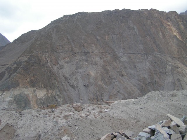
After the rainfall reports suggest that the highway was blocked in over 200 places by landslides, but most of these have now been cleared. However, the remaining blockages do seem to be extremely serious. This is the landslide at Chuchang (sometimes spelt Chochang), posted to the twitter account of Wasif Shakil:
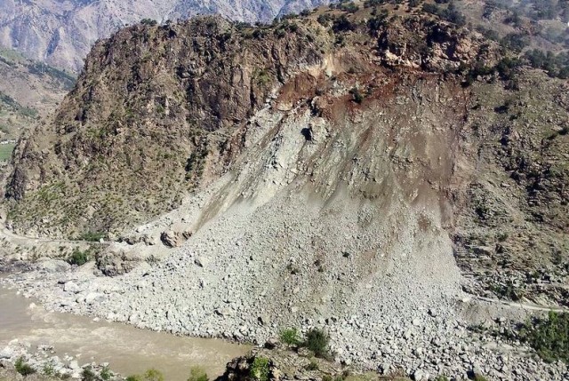
Landslide at Chuchang on the Karakoram Highway via Wasif Shakil
.
The challenges of clearing this landslide, and making the road safe, are clear. The Pamir Times article has an image of the attempts to create a new road across this landslide:
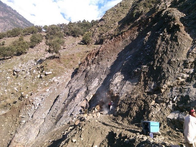
Attempts to create a new path through the landslide at Chuchang on the Karakoram Highway, via the Pamir Times
.
The other site appears to be at Kiyal. Gilgit News Time posted images of this landslide on 8th April:
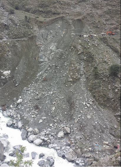
The landslide at Kiyal on the Karakoram Highway via Gilgit News Time
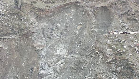
The landslide at Kiyal on the Karakoram Highway via Gilgit News Time
.
Given that the slide surface is solid rock and passes through the level of the road this is going to be extremely challenging to repair quickly.
The impact of these closures is serious. The Pamir Times reports shortages of food and fuel, with many areas also without electricity. But perhaps the biggest impact of the landslides is on the irrigation system:
The lands across Gilgit-Baltistan are irrigated by using glacial water brought to the human settlements by digging channels through vulnerable mountain sloped and rocks. These water channels have been damaged to a very large extent across the region, posing a serious threat to the livelihood means of thousands of farmers.
In a landscape that is genuinely astonishing, these channels are incredible feats of engineering. This is an example, cutting across a steep, unstable rock slope. that I photographed in Gilgit in 2010 when I was working on Attabad:
An irrigation channel near Gilgit on the Karakoram Highway
.
The loss of these channels, and the work that will be needed to restore them at a key point in the agricultural year, is very significant.
 Dave Petley is the Vice-Chancellor of the University of Hull in the United Kingdom. His blog provides commentary and analysis of landslide events occurring worldwide, including the landslides themselves, latest research, and conferences and meetings.
Muhammad Siyab rushed out of his house in the middle of the night and watched as a landslide destroyed his home and buried 25 people in his village of Othar-Nala in northern Pakistan’s Khyber Pakhtunkhwa province on Tuesday.
Torrential rain this week has triggered extensive landslides across northern Pakistan, resulting in high losses. Whilst this is an area that receives spring rains, multiple landslides to this degree are not normal, it being some months prior to the development of the southwest monsoon.
The disaster came as a complete shock to Muhammad Siyab, a farmer from the upper Kohistan Valley whose grandchildren were among the buried. He and his fellow villagers have still not managed to rescue relatives from the rubble. They don’t have the heavy equipment required and they are still waiting for relief workers to arrive.
[This appears to be a cut and paste from: http://www.thethirdpole.net/2016/04/08/northern-pakistan-faces-worst-landslides/ Non-relevant link removed D]
this obviously looks like a mortal danger to the CPEC project…
Landslide hazard is a common risk of mountainous areas regardless of country either from Africa/Asia or Europe.
Sometimes the capacity of even advance countries to combat against disaster gets total failure. Example of recent rainfall induced flood from Germany is eye-opening for all of us.
So, we should be always optimistic about disaster. Disaster cannot identify a human being. It always kills white, black and any other type of ethnicity.
Regards
Ijaz Ahnad
Geologist
Islamabad-Pakistan.