22 February 2012
The Tumbi Quarry landslide – an initial forensic examination of the images
Posted by Dave Petley
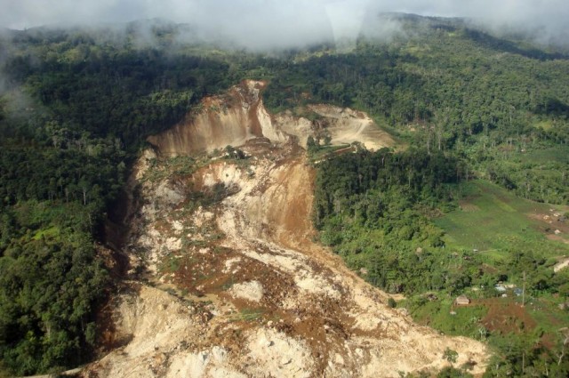
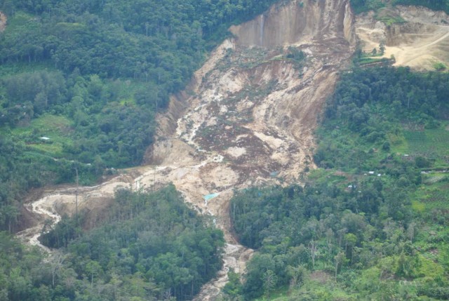
The LNG Watch blog has posted online some new images of the aftermath of the Tumbi Quarry landslide in Papua New Guinea. This is a good time to look in a little more detail at the landslide itself. The most interesting images are these two:
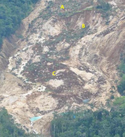
The second of these, assisted with some information from the first, suggests that this was a multi-phase landslide event. Let’s start by looking at the central portion of the landslide:-
I have annotated on the image above three key areas. In A there is an area of disrupted but intact vegetation, which must have come ass an almost intact block from the slope above. It is not back tilted, so the slide is not rotational, which is consistent with the very planar form of the (presumably joint-controlled) back scarp. At B there is an arcuate secondary scarp cut into the block that forms A, and below this is a flow deposit, of which the upper component clearly derives from B.
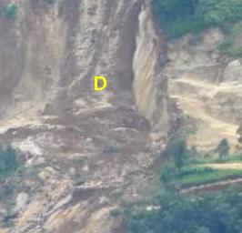
If we now look at the upper part of the landslide we see another secondary failure:
This landslide, marked D above, appears to be a late stage earthflow (it is mostly soil) over the back scarp.
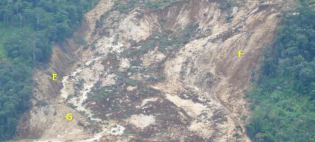
Let’s now take a look at the mid-part of the landslide. There is a marked difference between the left and right (as viewed from the image) sides of the landslide. The left side (marked E below) has a steep scarp that appears to be at least 10 m high:
The right side on the other hand still shows the extension of the ridge that runs across the slope, albeit with the vegetation stripped off, suggesting that the landslide was shallow in this region. So the landslide was deep on one side and quite shallow on the other. At G the landslide debris appears to have in part ridden over a section of rock, but presumably most of the debris was diverted around this into the centre of the landslide.
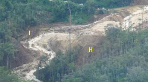
Done at the toe the landslide debris clearly spilt into two and followed the drainage lines. On the left side there is some evidence that it “cut the corner” on the inside of the first bend (marked H below) and super-elevated on the outside (marked as I):
On the other (right) side the debris appears to have travelled straight down the drainage line:
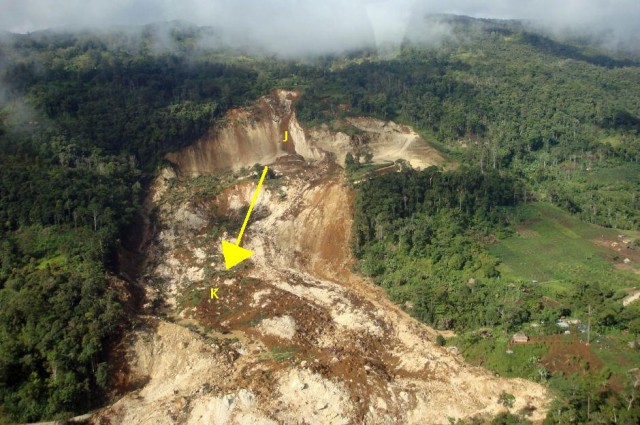
Of course what is not shown by all of this is the first event – i.e. the major failure that started the sequence of failures. We really need some idea of the form of the topography before the slides to get an idea of this, and we need to get on the ground to look in detail at the deposits that are not covered by the secondary failures. The most intriguing aspect is that the distribution of volume change in the head scarp source area does not seem to match the distribution along the track very well. In the image below, the zone of largest volume change is at J (ignore the superficial earthflow that has partially filled this area), but most of the debris appears to have passed through the area marked K (look at the flow lines, and bear in mind the almost vertical scarp on the left side). This implies that the initial part of the landslide may have followed the general trajectory shown by the arrow:
However, for the material highlighted in A in the third image above to move into the landslide, material from this zone must have moved out first. It seems likely therefore that the initial failure occupied the deeper portion of the area from J to K. To understand how and why this section failed we really do need to have an idea of the pre-failure topography and, critically, the location of the quarry and its spoil. I am particularly interested in the latter as none of the images show any waste tips that I can see, which means that this debris was either removed from the site or it has been incorporated into the slope failure.
So the burning questions remain:
1. Where was the quarry excavation?
2. Where was the spoil?
3. What was the rainfall in the period leading up to the slip?
It is deeply frustrating that we seem to be no closer to an answer to any of these questions.
Comments and thoughts, and alternative suggestions, are very welcome. It would be good to crowd-source an interpretation of this landslide head of the official investigation (?). My interpretation above should be considered to be no more than a set of hypotheses that need testing properly by the investigation team.



 Dave Petley is the Vice-Chancellor of the University of Hull in the United Kingdom. His blog provides commentary and analysis of landslide events occurring worldwide, including the landslides themselves, latest research, and conferences and meetings.
be nice to see a pre slide photo!
A road cut could help create a trigger or destabilize a slope.
I do not see a road running from the quarry to the main road. Did it get washed out? Does it go behind the ridge just below the remaining quarry and down that valley to the right? It appears the existing quarry road goes up hill to the right and ends (giving access to the upper part of the quarry) but could it go around a corner (out of sight) and double back down that valley? Is there another option?
Are those spoils below and slightly to the right of the remaining quarry, at least partly hidden by the ridge (a bright spot of dirt below the quarry road just above the lower ridge’s trees)?
Was there equipment on the site or did it get removed after the slide or was it destroyed?
[…] sure is the site prior to the landslide (compare the features outside the landslide area with the images in this post). I will blog on this properly later today, but as a taster here is the image. I think that […]
[…] In an earlier post I included a photo of the Tumbi Quarry site before the landslide. I thought I’d look at this image in a little more detail. The photograph was collected on 27th January 2010, i.e. almost two years before the landslide: […]
[…] Herald ran a story over the weekend about the Tumbi Quarry landslide in Papua New Guinea, which killed at least 25 people (and possibly as many as 60 people) in January. As a reminder, […]
I continue to advise resource developers in PNG on landslide risk and the importance in undertaking risk assessment studies from the beginning. Unfortunately it takes the tragic loss of life (and possible legal responsibility) for managers to get the message but that is now changing.
At Porgera in the late 1980s I stopped the development of a small (at that stage) gravel pit at the base of a very high vertical limestone cliff above a site earmarked (by the PNG Government) for a future township. A report had already identified the risk of rock fall from the cliff and set “safe” set-back distances for housing. The pit was in talus material and was not making any real impact on slope stability of the cliff face. However I stopped the quarry work because in the event of a rock fall (moderately likely) the company could not be blamed on the basis of under mining the cliff.
At Tumbi the natural slope configuration probably had a factor of safety better than 1:1. It was very likely not failing. The question is – Would that original slope be more or less likely to fail under the likely events of high rainfall and earthquake on that day, if the quarry had not been developed.