13 May 2010
Developments at Attabad
Posted by Dave Petley
I have today revamped the monitoring website of the Attabad landslide in Hunza, Pakistan to make the display of information more straightforward as we enter the end game of this situation. In the last day or so there have been three critical developments:
1. Seepage is increasing rapidly
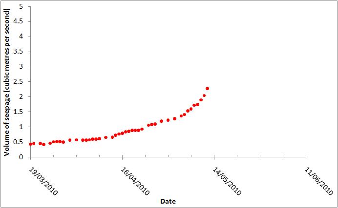
Today’s seepage figure is 2.53 cubic metres per second – that is a substantial increase on yesterday, as the graph below shows:
2. A new seepage point has developed
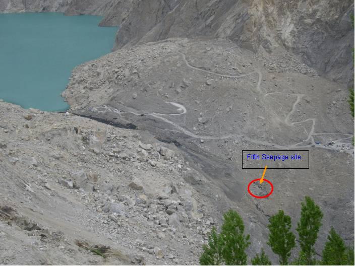
Part of the reason for the increase in seepage is the development of a new seepage point below the spillway. This is not unexpected, though the rate of seepage is increasing quite quickly at this point. The location is shown in this image, provided by Focus:
Note two things here. First, the seepage is probably allowing water to flow beneath the spillway, which will be reducing the resistance to erosion. Second, and more importantly, even though the water flow here is just 0.23 cubic metres per second, a substantial amount of scour and erosion has already been initiated. Readers will not need me to describe the implications of this in terms of the likely performance of the spillway when water flow commences.
3. The authorities are now admitting that the dam will probably breach
For the first time, government agencies are admitting that the dam is likely to erode away. For example, Onlinenews is reporting that Lt General Shahid Niaz stated today that the water will be flushed out within 2 to 3 days. This is a good development. Indeed, he is also reported to have said ““Such types of lakes have to ultimately breach and there is no chance for its preservation as a dam or a permanent water reservoir,”
I also note that he stated that “international experts’ help is also being taken on the issue”. I wonder who is providing this help, as they haven’t spoken to me. I am delighted that they are getting some expert input though.
I’ll post again on this tomorrow. The current probable window of overtopping is 22nd to 26th May, though this could easily change to an earlier date.


 Dave Petley is the Vice-Chancellor of the University of Hull in the United Kingdom. His blog provides commentary and analysis of landslide events occurring worldwide, including the landslides themselves, latest research, and conferences and meetings.
Keep up the good work Dave and thanks for the updates. Sure wish BBC and other int'l news agencies would report on this regularly. Thankful we have your blog and the Pamir Times.
i am just wondering why a dam cannot be built on this site……i mean its a god gifted thing we were going to build bhasha in 7 yrs with a lake of 11 km…this has been made naturally with a lake of 18 km…………so why not build a dam rt here in 6 months………and as far as i know the chinese made such an offer to pak govt
This is a excellent resource. Thanks for the helpful data, and graphs.
Thanks David for the latest information and daily updates. ya it looks this week is very crucial for the lake and it is its final week,but let me know how long after its first flow it can resist in the same hight or it will spillover within 24 hours,
what can be done to minimize Fast erosion? And will the Gilgit city be affected in case the dam bursts? and if yes, to what extent?
thanks for updates on this issue.video clips on disasterhttps://www.gulbtur.wordpress.com