15 May 2010
The likelihood of a flood from the Attabad landslide
Posted by Dave Petley
The water level at Attabad is now within ten metres of the base of the spillway at the saddle, and continues to rise at about 90 to 100 cm per day. Thus, water flow through the spillway is now about ten days away, or possibly less.
So what will happen when water flow starts? Regular readers will know that I have been continually pressing the authorities to assume that a large flood will occur, even if this was an outside possibility. My recommendations were, and still are, to evacuate everyone downstream of the dam located within 60 metres of the river level. Past experience suggests that the flood could be large all the way to Tarbela – i.e. that standard attenuation models don’t apply here.
Throughout this crisis I have maintained that a catastrophic flood was possible but not probable. This was very much based upon the plans for the spillway, which we were assured would be 30 metres deep, up to 40 m wide, and with a low longitudinal gradient. We were even assured that the base would be armoured to prevent erosion.
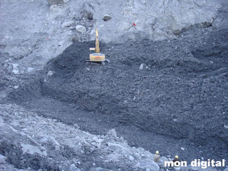
The reality is rather different. A couple of days ago the Pamir Times published this image of the spillway (the annotation is from them – I would like to formally thank them for highlighting the monitoring site I run):
Those building the spillway have admitted that it is just 5 metres wide and 14 metres deep. None of us should be under any illusions – this is unlikely to be large enough to cope with the flows that the river experiences in the summer floods. Furthermore, even though the flow from seepage that has developed below the spillway over the last few days is a fraction of the current inflow (seepage = 510 litres per second; inflow = 77,750 litres per second), the water flowing from the seepage point has been able to erode the dam materials. This does not bode well in terms of the landslide dam resisting erosion.
The increase in seepage rate remains a source of concern too, both in terms of the potential for an earlier water release and the likelihood of internal weakening of the dam structure.
All of this means that a flood is now likely, hopefully of just a moderate size, but possibly larger. Once again I urge, as I have throughout this crisis, that the authorities assume that the flood will be large and thus ensure that everyone within 50 metres of the river between Attabad and Tarbela is protected.
Finally, I just cannot understand why the authorities are not getting expert advice to help them to deal with this. Help is being offered – why are they not accepting it?


 Dave Petley is the Vice-Chancellor of the University of Hull in the United Kingdom. His blog provides commentary and analysis of landslide events occurring worldwide, including the landslides themselves, latest research, and conferences and meetings.
Outstanding summary, thank you! I don't understand how officials can say they'll drain the lake by the end of the month. Wouldn't the spillway have to reach the bottom of the lake for this to be possible? Or am I missing some law of physics long since forgotten? See NY Times this week: http://www.nytimes.com/2010/05/14/world/asia/14briefs-Pakistan.htmlKeep up the great work Dave, your service is invaluable to all who love the region. – Cheryl Carruth, USA
Hello David,i would just say why government officials are not taking help from any international expert because they want more destruction to come only for the international Aid and money on the name of calamity. this is what the corrupt pakistani government makes its policy.there must be an international inquiry on this disaster, why the government of pakistan has neglected this calamity and did nothing to save the upstream villages and now its resulting a huge flood to downstream.
DaveAs always thanks. I think you are absolutely right about flood attenuation. Given the confined narrow nature of the valley, the flood may act like a moving dam with the flood front being filled with debris.A cautionary approach seems warranted downstream.
Hi David,Great to keep up with your postings. When you mention 60 feet from the Hunza River I assume you mean 60 feet above the River? Right? I work in Gilgit and our project is 48 feet above the confluence of the Gilgit/Hunza Rivers. We are preparing.
Has anybody produced a detailed digital terrain model of the area? This, together with estimated inflow and outflow rates, should have enabled a reasonable estimation of the rate of increase in lake height /change in freeboard with time.