11 May 2010
Possible flowslide (not a sinkhole) in St Jude, Canada
Posted by Dave Petley
The Canadian media is reporting the case of a “sinkhole” that developed in St Jude, 77 km to the north of Montreal, last night. The sinkhole included a family house, with four people inside. At the moment these occupants are reported to be missing.
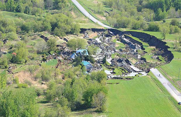
The Montreal Gazette has a photo gallery of the site. One of the photos is this one:
Based upon this image this does not look like a sinkhole but instead to be a quick clay slide, probably in Leda Clay. Such slides are not uncommon in this area. I have covered a previous example in Norway on this blog. The famous Rissa quick clay landslide in Norway is available as a video here if you want an idea of the extreme end of this type of failure.Quick clay slides often occur on very low angled slopes, and can be triggered through ground disturbance which causes the clay to restructure, allowing it to flow.
At the moment I am unsure of the exact location of this event, but St Jude is at 45.77 N, 72.99 W.
Hat-tip to Peter Weisinger for highlighting this one.


 Dave Petley is the Vice-Chancellor of the University of Hull in the United Kingdom. His blog provides commentary and analysis of landslide events occurring worldwide, including the landslides themselves, latest research, and conferences and meetings.
Looking at the fifth photo in The Gazette images (elevated view over site with road running into background)and comparing with the roads via Google Earth, the site looks to be 3.83km to the north west of St Jude on a heading of 30.02 degrees at45°48'16.07"N72°57'50.74"WThe Gazette's elevated view would appear to be looking back SE towards St Jude.
Looking at the fifth photo in The Gazette images (elevated view over site with road running into background)and comparing with the roads via Google Earth, the site looks to be 3.83km to the north west of St Jude on a heading of 30.02 degrees at45°48'16.07"N72°57'50.74"WThe Gazette's elevated view would appear to be looking back SE towards St Jude.
Looking at the fifth photo in The Gazette images (elevated view over site with road running into background)and comparing with the roads via Google Earth, the site looks to be 3.83km to the north west of St Jude on a heading of 30.02 degrees at45°48'16.07"N72°57'50.74"WThe Gazette's elevated view would appear to be looking back SE towards St Jude.
Looking at the fifth photo in The Gazette images (elevated view over site with road running into background)and comparing with the roads via Google Earth, the site looks to be 3.83km to the north west of St Jude on a heading of 30.02 degrees at45°48'16.07"N72°57'50.74"WThe Gazette's elevated view would appear to be looking back SE towards St Jude.
Yes, i'm also pretty shure it was a quick clay (or may be a rotationnal slide – but way too much retrogression.)I had the chance to study this sector in 1995 when I did my thesis on landslides. Carl
Thanks for keeping us updated about landslides. I tweet your blog quite often from @geosociety.
Thanks for keeping us updated about landslides. I tweet your blog quite often from @geosociety.
Looks very much like a slide. I recall hearing of slides in this region caused by thixotropic failure of clays.Why do you suppose the initial reaction is 'sinkhole'?
CBC just announced that the family were in their basement on the couch in front of the television and it is speculated they were watching the Montreal Canadien hockey playoff game (apparently they were fans). All four died.
Apart from all the news media "sinkhole" nonsense, there was a decent interview last night on the Discovery Channel with someone who has a clue what they're talking about:http://watch.discoverychannel.ca/#clip301180Howard