19 December 2014
Data from space illuminates Calaveras creep
Posted by kwheeling
By Chris Cesare

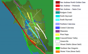
The San Andreas Fault system around the Bay Area. A new study has found that the Hayward and Calaveras faults are connected underground, a fact that could make earthquakes that occur along the faults bigger.
Credit: Leonard G.
Scientists have used satellites to more accurately measure the slow creep of land along the Calaveras and Hayward faults east of the San Francisco Bay, a finding that helped the researchers estimate the magnitude of future earthquakes.
Both the Calaveras and Hayward faults are part of the San Andreas system, which sits at the boundary of two massive slabs of the Earth’s crust called the North American and Pacific plates. The plates slide slowly past one another, sometimes getting stuck and then slipping, releasing energy and causing the Earth to shake. Along the Calaveras and Hayward faults—smaller cracks on top of the plates—the land also moves steadily, a movement that geologists call creep
Scientists have scrutinized the creep of land along the Hayward fault for years using a network of more than 30 ground-based instruments, but only nine such instruments monitored the longer Calaveras fault.
“The idea was to try to get a better estimate of creep,” said Estelle Chaussard, a postdoctoral fellow in earth and planetary science at the University of California, Berkeley.
Now, Chaussard and her colleagues have used 19 years of satellite measurements to study the Hayward and Calaveras complex. Their results provide a detailed map of creep along the Calaveras fault. They found that the fault has areas that move as much as 0.47 inches per year (12 millimeters per year) and some that remain motionless. They also found that if a slip occurs along the southern part of the Calaveras, it could unleash a magnitude 7.1 earthquake, larger than previously thought.

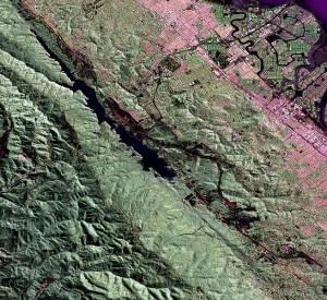
The dark black in the center of the image is a portion of the San Andreas Fault that runs west of the San Francisco Bay, near San Mateo. New research shows that two faults in the San Andreas system, the Hayward and Calaveras faults, are actually connected underground.
Credit: NASA
Chaussard explained the results in a poster Wednesday morning during the American Geophysical Union’s Fall Meeting in San Francisco.
To measure the movement of land along the faults, Chaussard and her colleagues used images from two satellites and a technique called interferometric synthetic aperture radar. This technique, called InSAR for short, uses light reflected off the ground to measure movement, much like radar. But instead of simply using the signal to find the range of an object, it compares two different bounce-and-return signals, analyzing them for slight differences that indicate movement. Scientists have used InSAR for more than two decades to monitor the Earth for evidence of creep, earthquakes and even volcanic activity.
In addition to the Calaveras creep found with InSAR, the team also found that creep was occurring more than 9.3 miles (15 kilometers) farther south along the Hayward fault than previously known.
Using this data on creep—especially the spots without creep where stresses in faults build up—and measurements of small periodic earthquakes, the team was able to model the underground structure of the fault system. Their reconstruction of the geometry of the Hayward and the Calaveras faults provided evidence for an underground connection that scientists have suspected for nearly a decade. Using this picture, they calculated new estimates for the amount of energy stored in stresses along the fault..
“The structure of the faults is important because ruptures can’t spread if they’re not directly connected,” Chaussard said.
It’s not a prediction of when an earthquake will occur, Chaussard said.
“It has to happen at some point, so people should be prepared,” she said. “And they’re connected, so it has the chance to be much larger.”
Chris Cesare is a science communication graduate student at UC Santa Cruz.


 GeoSpace is a blog on Earth and space science, managed by AGU’s Public Information staff. The blog features posts by AGU writers and guest contributors on all sorts of relevant science topics, but with a focus on new research and geo and space sciences-related stories that are currently in the news.