November 9, 2020
Mount Cayley Glacier, BC Loses 40% of Length 1985-2020
Posted by Mauri Pelto
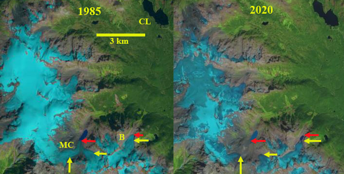
Mount Cayley Glacier (MC) and Brandywine Glacier (B) near Callaghan Lake (CL) in 1985 and 2020 Landsat Images. Yellow arrow indicates 2020 terminus, red arrow indicates 1985 terminus location.
Mount Cayley Glacier and Brandywine Glacier drain the northeast flanks of Mount Cayley and Brandywine Mountain in the Coast Range, 25 km west of Whistler, BC. Both glaciers drain in to Callaghan Creek, a tributary to Cheakamus Rover. Retreat of Mount Cayley Glacier has led to separation into two glaciers. Retreat of Brandywine Glacier has led to development of a proglacial lake. BC Hydro operates the 157 MW Cheakamus Generating Station with a tunnel and two penstocks carrying the water 11 kilometres from Daisy Lake Reservoir to the Cheakamus GS. The Cheakamus River has substantial salmon populations including Pink, Coho, Steelhead and Chum. For Chum BC Hydro maintains an annual escapement and spawning survey. The main run for Chum is in the fall from Oct. 15 to early December, with most years seeing more than 100,000 adult Chum heading upstream to spawn (Middleton et al 2019). This is a 4% survival rate from the typical salmon fry population that exceeds 2.5 million (Middleton et al 2019). Here we examine Landsat imagery to indicate the glacier change from 1985-2020.
In 1985 Mount Cayley Glacier had two branches that merged and terminated in a proglacial lake at 1520 m. The east arm flowed north from the west ridge of Brandywine Peak and the west branch drained the east side of Mount Cayley. The west arm was 3.75 km long and the east branch 1.8 km long. Brandywine Glacier was 1.2 km long terminating at 1575 m. By 1993 the two arms of the Cayley Glacier had separated. The snowline was particularly high with less than 10% of each glacier retaining small snowpatches above 2000 m. The end of winter in 2015 a UBC Ski trip across this area illustrates how beatiful it is and how snowy. Depsite this snow covered look, the snowpack in 2015 was low and near the end of a warm summer the snowline was again above 2000 m. In 2017 the proglacial lake in front of Brandywine Glacier is 300 m long. The snowline is lower at 1850 m. In 2020 Brandywine Glacier continues to terminate in the small proglacial lake and has retreated 400 m during the 1985-2020 period. The east arm and west arm of Cayley Glacier have retreated 950 m and 1400 m respectively in this 35 year interval. In both case this is 40% of the entire length of the glacier lost. The glacier now terminates at 1720 m.
In 2020 the snowline was 1900-1950 m. The continued limited area of the accumulation zone is driving mass balance losses and retreat. Across this region Menounos et al (2018) identified a mass loss for glaciers in this region of ~0.5 m year from 2000-2018. This has driven retreat of small and large glaciers such as Franklin Glacier, Bridge Glacier and Stave Glacier. In 2015 the snowline was the highest of the last 37 years in the North Cascades, WA a short distance south (Pelto, 2018).
Mount Cayley Glacier (MC) and Brandywine Glacier (B) near Callaghan Lake (CL) in 1993 and 2017 Landsat Images. Yellow arrow indicates 2020 terminus, red arrow indicates 1985 terminus location.
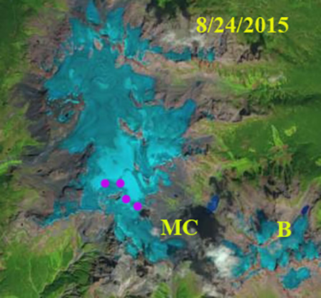
Mount Cayley-Powder Mountain Icecap in 2015 illustrating lack of retained snowcover in late August. Purple dots indicate snowline above Mount Cayley Glacier. MC=Mount Cayley Glacier, B=Brandywine Glacier
Canadian National Atlas map of region indicating flow direction of Mount Cayley and Brandywine Gacier.


 Dean of Academic Affairs at Nichols College and Professor of Environmental Science at Nichols College in Massachusetts since 1989. Glaciologist directing the North Cascade Glacier Climate Project since 1984. This project monitors the mass balance and behavior of more glaciers than any other in North America.