
June 10, 2019
Asejiaguo Glacier, China Retreat and Lake Expansion
Posted by Mauri Pelto
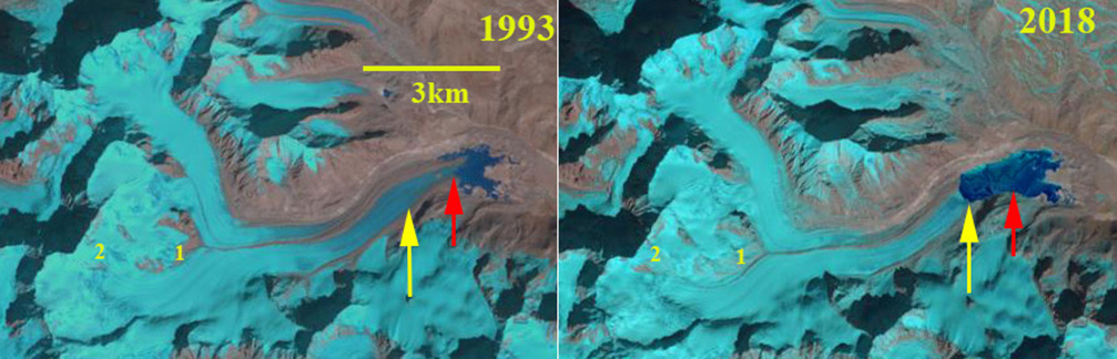
Asejiaguo Glacier in Landsat images from 1993 and 2018. The yellow arrow indicates the 2018 terminus and the red arrow the 1993 terminus location. Point 1 and 2 are areas of expanding bedrock in the 5400-5600 m.
Asejiaguo Glacier drains east from the China-Nepal Border and is at the headwaters of the Yarlung Tsangpo, which becomes the Brahmaputra River. The Yarlung Tsangpo powers the 510 MW Zangmu Hydropower Station. Gardelle et al, (2013) identified this glacier as part of the West Nepal region, which experienced mass loss averaging -0.32 m/year from 1999-2011. The changes of the Asejaguo Glacier are examined for the 1993 to 2018 period using Landsat imagery. Neckel et al (2014) examined changes in surface elevation of the glaciers and found this region lost 0.37 m/year from 2003 to 2009.
In 1993 the glacier terminated in a small proglacial lake that is ~1 km long at 4900 m. At Point 1-2 there is limited exposed bedrock at 5400-5600 m, which is near the snowline, the head of the glacier is at 6000 m. There is a prominent medial moraine that begins at 5300 where the north and south tributaries join. The greater width of the southern tributary indicates this is the large contributor. In 1994 the snowline is higher at 5500 m, but there is still only a small outcrop of bedrock at Point 2. By 2016 the proglacial lake has expanded to a length of over 2 km. At Point 1 and 2 there is a greatly expanded area of bedrock, and the separation of a former tributary near Point 1 from the main glacier. In November 2018 there is fresh snowfall obscuring the exposed bedrock at Point 1 and 2. The retreat from 1993-2018 is 1.5 km, and the expanding proglacial lake is over 2.5 km long. The expanding bedrock areas in the 5400-5600 m range indicate the reason rise in snowline that has generated mass loss and ongoing retreat.
The behavior of this glacier matches that of other glaciers in the regions such as Chako Glacier and Ribuktse Glacier

Asejiaguo Glacier in Landsat images from 1994 and 2016. The yellow arrow indicates the 2018 terminus and the red arrow the 1993 terminus location. Point 1 and 2 are areas of expanding bedrock in the 5400-5600 m.
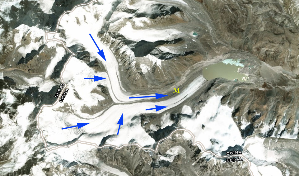
Asejiaguo Glacier, blue arrow indicate flow direction, M indicates the medial moraine, the China-Nepal border is also noted.
 Dean of Academic Affairs at Nichols College and Professor of Environmental Science at Nichols College in Massachusetts since 1989. Glaciologist directing the North Cascade Glacier Climate Project since 1984. This project monitors the mass balance and behavior of more glaciers than any other in North America.