
April 13, 2018
Pico Alto Glacier, Chile Retreat New Lake Formed
Posted by Mauri Pelto
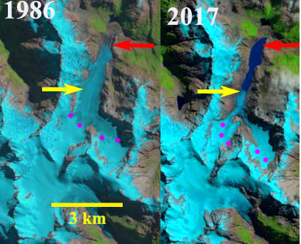
Pico Alto Glacier, Chile in 1986 and 2017 Landsat images indicating the retreat. Red arrow indciates 1986 terminus, yellow arrow the 2017 terminus,and purple dots the snowline.
Pico Alto Glacier, Chile drains north from the Argentina-Chile border entering the Rio Puelo and eventually Lago Tagua. The glacier ongoing retreat is similar to the nearby Hornopiren Glacier and Erasmo Glacier. Davies and Glasser (2012) mapped the glaciers in the Hornopiren region and found a 15 % area loss from 1986 to 2011.
In 1986 there was no lake at the terminus of the glacier and the snowline is near the main junction. By 2000 the glacier had retreated 1200 m opening a new lake. The eastern arm of the glacier did not retain significant accumulation. In 2016 the snowline again left the eastern tributary without retained accumulation. In fact the connection to the larger western tributary has been greatly reduced. By 2017 the glacier has retreated 2.4 km with a lake of nearly the same length having formed, this is 40% of the total glacier length lost in three decades. The eastern tributary due to a lack of retained snowpack will continue to wither away. The main glacier can survive in a reduced state with current climate. Wilson et al (2018) noted a substantial growth in the number of lakes in the central and Patagonian Andes due to the ongoing rapid retreat. Harrison et al (2018) also observed the number of glacier lake outburst floods have declined despite the increase in lakes.
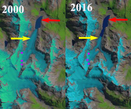
Pico Alto Glacier, Chile in 2000 and 2016 Landsat images indicating the retreat. Red arrow indicates 1986 terminus, yellow arrow the 2017 terminus,and purple dots the snowline.

Google Earth view of the Pico Alto Glacier (PA) indicating flow, blue arrows, 1986 terminus red arrow and 2017 terminus yellow arrow
 Dean of Academic Affairs at Nichols College and Professor of Environmental Science at Nichols College in Massachusetts since 1989. Glaciologist directing the North Cascade Glacier Climate Project since 1984. This project monitors the mass balance and behavior of more glaciers than any other in North America.
Very much informative sir. I’m visiting regular your posts. Can I share my glacier related observations to this blog?