
November 28, 2016
Hornopirén Glaciers, Chile in Spectacular Retreat
Posted by Mauri Pelto
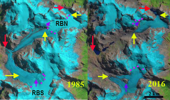
Landsat comparison of Rio Blanca Glaciers in Hornopirén National Park, Chile from 1985 to 2016. Red arrow 1985 terminus, yellow arrow 2016 terminus, purple dots the snowline and purple arrows expanding bedrock areas amidst the glacier.
Hornopirén National Park is in the Los Lagos region of Chile. The park is host to a number of glaciers that are in rapid retreat. Davies and Glasser (2012) mapped the area of these glaciers with 113 square kilometers in 1986 and 96 square kilometers in 2011. The retreat of the largest glaciers in the park is nothing short of spectacular in recent years. Here we examine Landsat imagery to identify changes in two or the larger valley glaciers from 1985-2016. These glaciers from the headwaters of the Rio Blanco and are designated Rio Blanco North (RBN) and Rio Blanco South (RBS). Rio Blanco enters the ocean just east of the community of Hornopirén.
In 1985 the two glaciers merged just before the western terminus of the icefield at 820 m, red arrow. The snowline was at 1300 m. There is also an eastern outlet of RBN, terminating at the north end of a basin, red arrow. By 1998 RBN and RBS had separated by over 1 km with the formation of a new lake at the former terminus. The eastern terminus of RBN has begun retreat and is now ending in a proglacial lake. RBS is developing a nunatak at the purple arrow. The snowline was again near 1300 m. By 2016 RBN has retreated 4.5 km, and now terminates at 1200 m, yellow arrow. The deglaciated valley now hosts three alpine lakes that did not exist in 1985. The eastern terminus of RBN has retreated 1100 m and is still terminating in an expanding alpine lake, yellow arrow. By 2016 RBS had retreated 3.4 km since 1985, terminating at 1180 m, yellow arrow. The nunatak in the lower section of RBS, purple arrow, has continued to expand. RBN has lost 56% of its length since 1985 and RBS 37% of its length.The snowline in 2015 and 2016 is at 1600-1700 m. This leaves only a small percentage of the glacier area above the snowline. The large valley glaciers that just 30 years dominated the headwaters of Rio Blanco have lost much or their area and will soon be small slope glaciers clinging to the highest peaks. Retreat here is more extensive than seen 100 km to the northwest at Calbuco Volcano and for the Northern Patagonia Icefield.

Landsat comparison of Rio Blanca Glaciers in Hornopirén National Park, CVhile from 1998 to 2015. Red arrow 1985 terminus, purple dots the snowline and purple arrows expanding bedrock areas amidst the glacier.
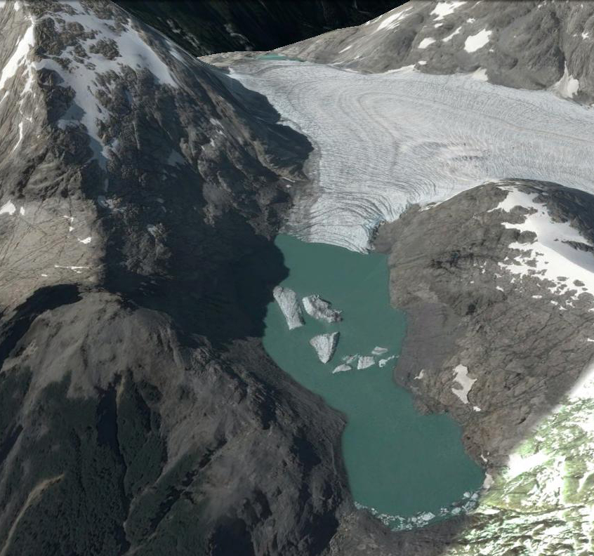
East Terminus of Rio Blanca North, with the newly formed lake. This terminus is above 1300 m and has retreated largely via iceberg calving.
 Dean of Academic Affairs at Nichols College and Professor of Environmental Science at Nichols College in Massachusetts since 1989. Glaciologist directing the North Cascade Glacier Climate Project since 1984. This project monitors the mass balance and behavior of more glaciers than any other in North America.