
October 11, 2016
Shatter & Shudder Glacier Retreat, British Columbia Lakes Form
Posted by Mauri Pelto

Red arrow is the 1985 terminus location and yellow arrow the 2016 terminus location. Note the formatiion of new lakes at end of both glaciers. Purple dots is the transient snowline in August of each year.
Shatter and Shudder Glacier are at the eastern end of the Spearhead Range in Garibaldi Provincial Park, British Columbia. Osborn et al (2007) mapped the Little Ice Age extent of the glaciers compared to the 1990’s margins indicating a retreat of 300 m for Shatter Glacier and 700 m for Shudder Glacier (see below). Koch et al (2009) identified the recession in area from 1928 to 1987 noting a 6% loss in Shatter Glacier and 22% loss for Shudder Glacier. Koch et al (2009) identify an 18% loss in area from 1987-2005, indicating considerable recent change in the Park. Here we use Landsat imagery from 1985-2016 to update glacier change.
In 1985 there are no lake at the terminus of either Shatter or Shudder Glacier. In 2002 a lake has formed at the terminus of Shudder Glacier, but not Shatter Glacier. In 2016 both glaciers have proglacial lakes that have formed, and the terminus of both glaciers have retreated from the lakes. This marks a retreat of 325 m on Shudder Glacier and 275 m on Shatter Glacier since 1985. Shudder Glacier retreated more rapidly in the first half of this period, while Shatter Glacier has experienced most of the retreat since 2005.
On Shatter and Shudder Glacier In 1987 the late August image indicates the snowline is at 2040 m, in mid-August 2015 the snowline is at 2250 m. In late August of 2014 the snowline was at 2120 m. In mid-August 2016 the snowline is at 2080 m. The higher snowlines are an indicator of mass loss for these glaciers that in turn drives retreat. The region continues to experience significant loss in glacier area and development of many new alpine lakes with glacier retreat, five new lakes since 1987 just in this range with seven glaciers. Spearhead and Decker Glacier are two other glaciers in the range that have developed new lakes since 1987. Nearby Helm Glacier is faring even worse.
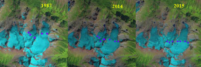
Landsat images from 1987, 2014 and 2015 indicating the transient snowline position at the purple dots on Shatter and Shudder Glacier.
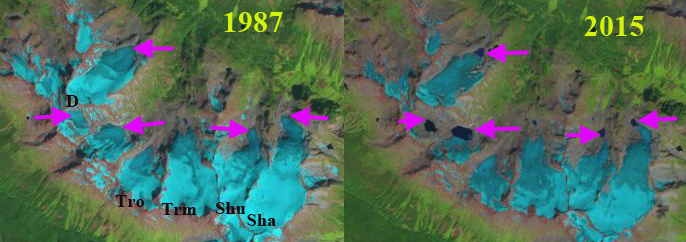
Pink Arrows indicate five new alpine lakes that have developed since 1987 as Spearhead Range glaciers have retreated

Map of Spearhead Range glacier extent for LIA-Bold lines and 1987, light lines from Osborn et al (2007)
 Dean of Academic Affairs at Nichols College and Professor of Environmental Science at Nichols College in Massachusetts since 1989. Glaciologist directing the North Cascade Glacier Climate Project since 1984. This project monitors the mass balance and behavior of more glaciers than any other in North America.