14 February 2013
The geology and a possible mechanism of the Hatfield Stainforth colliery landslide
Posted by Dave Petley
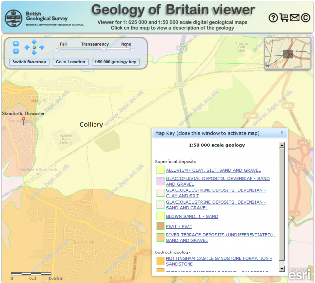
Unfortunately, overnight no new images have appeared of the Hatfield Stainforth landslide, so it is difficult to know whether the landslide has now stopped moving. The morphology of the landslide continues to suggest to me that this is a bearing capacity failure. I have taken a quick look at the excellent BGS Geology of Britain Viewer, which produces the following map (I have marked the approximate location of the colliery at which the landslide at occurred):
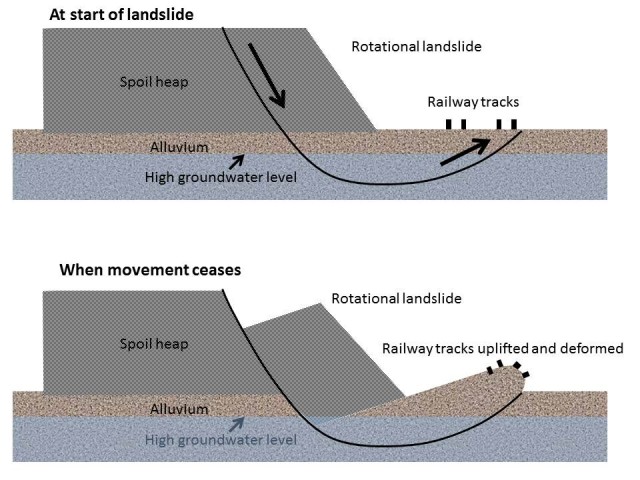
The map shows that underlying the location of the spoil tip is a layer of alluvium – basically soft sediments such as sands and gravels deposited by ancient rivers. These are comparatively weak materials, especially when wet. So, my hypothesis is that the weight of the spoil tip has caused the development of a failure through these materials, which has then generated a landslide with a rotational geometry. The sketch below is my suggested interpretation, with the spoil sitting over a layer of alluvium. The very wet weather over the last few months has led to a high groundwater level, which in turn has reduced the strength of the alluvium. This has then failed with the geometry shown in the upper sketch – the rotational landslide has then progressively moved to generate the geometry in the bottom sketch:
The good news is that this type of landslide is self-stabilising – eventually there is enough material uplifted to balance the load of the spoil, and movement terminates. However, from this it is not difficult to understand from this why it is a challenge to re-establish the railway line. If the uplifted material under the tracks is removed the spoil will not be in balance and the landslide will reactivate. So, to stabilise this slide either the spoil at the back of the displaced block will need to be removed or the strength along the shear surface will need to be increased. Neither are straightforward. Only when that is achieved can the material under the track bed be excavated.
Incidentally, back at the end of November I noted the following in relation to landslides in the UK:
So what next?
The heavy rainfall has now moved away, to be replaced by cold weather, so the immediate threat should start to subside. However, for some slopes the groundwater level will still be rising as the rainfall percolates through, so more landslides are possible. It is notable though that all of the above landslides are shallow – so far there is not much sign of the deep-seated landslide systems reactivating. This is almost certainly because groundwater levels were so low after the prolonged drought that ended in the early summer. These deep groundwater levels will now be rising, so don’t be at all surprised if there are reports of larger landslide movements over the next few months. Places such as Dorset and the Isle of Wight, where there are large coastal landslide systems, will be particularly vulnerable. Such landslides represent a comparatively low level of risk to life, but can cause extensive property damage. It will be an interesting winter.
Thus, it is not really surprising that we are now seeing deep-seated landslides developing. I expect that there will be more over the next two or three months.


 Dave Petley is the Vice-Chancellor of the University of Hull in the United Kingdom. His blog provides commentary and analysis of landslide events occurring worldwide, including the landslides themselves, latest research, and conferences and meetings.
Rotational landslides are sometimes called toreva blocks (e.g. http://web.mst.edu/~rogersda/cp_megalandslides/toreva,_az.htm) . I’ve seen pictures of landfills with the same presentation.
Large spoil dumps such as these are sufficiently large to develop their own water table that may rise to the upper surface of the dump above the surrounding countryside, especially as the usual practice is to capture stormwater on the upper surface rather than allowing it to discharge over the sides. In desert areas even moderately sized spoil dumps will often discharge water for a couple of years following the last rain fall event. Considering the location of the stockpile and the amount of recent rainfall it is probable that the water table within the stockpile is high and is likely to be discharging into the local countryside elevating the water table above natural levels.