2 August 2010
Pakistan floods – the progression of the flood wave down the Indus River
Posted by Dave Petley
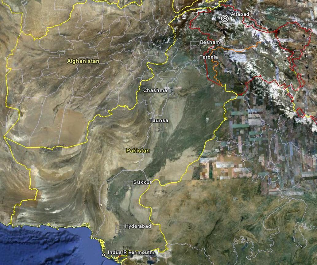
The floods in Pakistan appear to be starting to generate substantial interest in the UK, although this may in part be a result of the perhaps surprising decision of the Pakistan president to travel to London today. Whilst the crisis continues to develop in the north of the country, of equal concern now must be the progression of the flood wave down the Indus River. Of course Pakistan is a country built around the Indus – the green swathe that cuts north-south across the deserts of central and southern Pakistan (see image below) is essentially defined by the Indus and its tributaries. The Google Earth image shows Pakistan with the various gauging stations and other larger settlements on the Indus:
The passage of the flood wave is rather well illustrated by this series of hydrographs, from the Flood Forecasting Division website. The units are cubic feet per second – there are 35.3 cubic feet in a cubic metre.
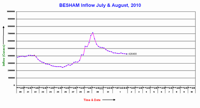
The hydrograph for Besham, in the north looks like this. The peak occurred around about midnight on 29th July.
A little further downstream lies Tarbela, whose hydrograph looks like this. The peak occurred early on 30th July. Note that Tarbela is a (very) large dam, so will probably have modified the flow somewhat.
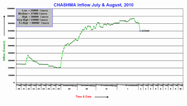
Further downstream lies Chsashma (see the map above), whose hydrograph looks like this. Note that here the peak occurred late on 1st August:
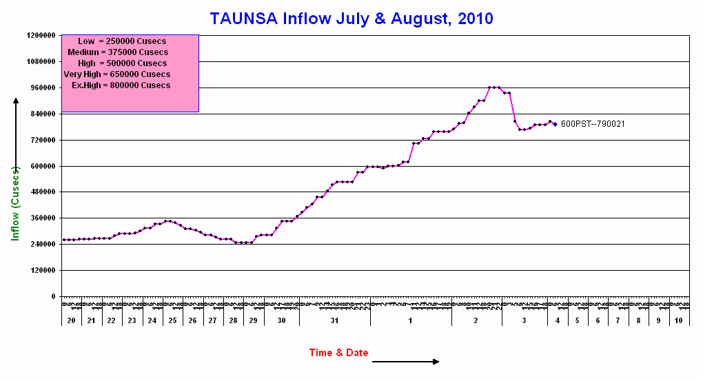
And downstream again is Taunsa (see map above), where the hydrograph looks like this. In this case the peak flood has yet to arrive. However, already the flood is defined as “extremely high”.
Taunsa is 800 km from the mouth of the river as the crow flies (so over 1000 km along the length of the river), so it will take some days for the flood wave to reach the sea. These lower reaches are mostly surrounded low lying land – the fabulous image below, by Najamuddin Bhatti, shows Sukkur on the banks of the Indus for example:
The reasons for concern about the potential impact of this flood wave downstream are clear.


 Dave Petley is the Vice-Chancellor of the University of Hull in the United Kingdom. His blog provides commentary and analysis of landslide events occurring worldwide, including the landslides themselves, latest research, and conferences and meetings.
Hopefully, there won't be any casualties downstream as evacuation had already begun. Northern parts were taken by storms and thousands precious lives were lost. But it’s a system of life.
Why aren't the flooded rivers highlighted on your map? It is very hard to find the names and locations of the flooded rivers in the news. Most just have photos and say that its the NWFP.
NASA has some satellite pictures of the flooding at:http://earthobservatory.nasa.gov/IOTD/view.php?id=44991Clicking the images brings up much larger ones, making it easier to locate the flooding with respect to landmarks (at least for those of us not familiar with Pakistan).
If you are interested in sending aid to the locals affected by this calamity, I highly recommend this organization.http://www.hidaya.org/social-welfare/disaster-relief/-pakistan-floods-2010
Hi Dave, Thank you for putting this up on your blog. The destruction is indeed massive with 15 million people affected directly. A quarter of the total land is said to be affected by floods. I have launched a personal initiative of collecting funds from Australia. Please visit my blog for details. http;//www.pakistanfloods-sha.blogspot.com
Excellent material on the subject. I may kindly be allowed to use this study.
[Yes no problem. D.]