
5 April 2016
Melt-driven streams on Greenland’s ice sheet shape landscapes faster than rivers on land
Posted by Lauren Lipuma
Study provides new tool to probe meltwater drainage that could also help project glacial response to climate change, according to researchers
by Jim Barlow

The Greenland ice sheet is the second largest ice body in the world. New research shows that erosion by summertime melt-driven streams on the ice sheet shapes landscapes similarly to, but much faster, than do rivers on land.
Credit: Christine Zenino (CC BY 2.0 via Wikimedia Commons)
Erosion by summertime melt-driven streams on Greenland’s ice sheet shapes landscapes similarly to, but much faster, than do rivers on land, according to a new study.
The approach used to study the drainage system of the ice sheet should serve to broaden the scientific understanding of melt rates and improve projections about ice sheet response to climate change, said Leif Karlstrom, a geologist at the University of Oregon in Eugene and lead author of the study.
The study, published last week in Geophysical Research Letters, a journal of the American Geophysical Union, also found that the topography of Greenland’s bedrock below the slowly flowing ice sheet has a role in the formation of basins in the ice as high-elevation streams make their way downward toward the sea.
“How fast is the ice sheet melting, and how much the melt will contribute to rising sea levels are important questions,” Karlstrom said. “It is important to quantify the melt rate, but that is not easy. Our study allows us to use geometric characteristics of the channel network — their patterns on the landscape — as a diagnostic tool.”
Projections on sea-level rise, such as those done with remote sensing or satellite observations, he said, have been difficult to determine accurately because melt rates vary widely each year, based on such factors as summer temperatures and elevations across the ice sheet.
In the study, Karlstrom and Kang Yang of the University of California, Los Angeles analyzed high-resolution satellite imagery from NASA digital elevation models that let them see the slope of the ice sheet and underlying bedrock. They focused on stream channels at four levels of the ice sheet, from 1,000 meters (3,280 feet) to 1,600 meters (5,249 feet), of southwest Greenland.
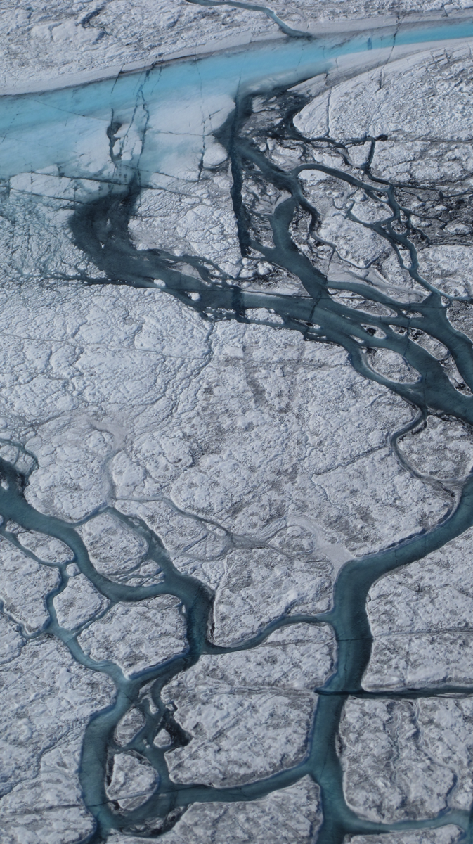
Meltwater creates rivers that flow across the ice sheet.
Credit: M. Tedesco/CCNY.
Geometrical characteristics of these streams — called supraglacial channels because they occur on the ice surface — mimic features often found for rivers on land. Such similarities of erosion patterns on ice and land, despite having different mechanisms, came as a surprise, Karlstrom said. On the ice sheet surface, erosion occurs as meltwater streams carve drainage channels by melting underlying ice. On land, rivers carve drainage channels by pushing and plucking sediment as they flow toward the sea, cutting down as the land surface uplifts due to tectonic activity.
Geologists who study geomorphology — how landscapes form — now have a virtual real-time model to test theories of landscape evolution, Karlstrom said. River erosion on land occurs over millions of years, but streams on the ice sheet carve their routes much more rapidly. In the study, researchers documented daily incision by flowing meltwater of up to 10 centimeters (4 inches).
“It’s lower elevations at the margins of the ice sheet that experience the most melt,” Karlstrom said. River erosion stops each year when freezing temperatures return. Frozen channels from previous years remain visible, providing a yearly history of erosion patterns much like tree rings reflect age, he said.
In addition to using glacial melt to test theories of land-based geological processes, the researchers suggest an application to studies of other planets.
— Jim Barlow is director of science and research communications at the University of Oregon. The University of Oregon posted this as a press release and as a blog on the UO website.