
16 April 2010
“Although we’re pretty good at saying when an eruption will start, we’re not so good at saying when it’s going to end”
Posted by Michael McFadden
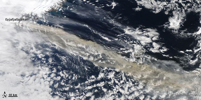
An image of the plume from Eyjafjallajökull, captured by a NASA satellite on 15 April. (Credit: Jeff Schmaltz, MODIS Rapid Response Team at NASA)
Here’s one curious consequence of Iceland’s volcanic ash clouds grounding airplanes across Europe: Scientists attending a volcanology meeting in Paris are temporarily stuck there. That’s where the AGU Geohazards blog reached John Eichelberger, Volcano Hazards Program Coordinator at the U.S. Geological Survey (and an AGU member), who responded to our questions (see below) about how volcanologists and weather services work together to forecast volcanic activity and the spread of ash plumes–and to prevent tragedies.
“My colleagues and I are stuck here because of the ash, so it’s a little bit ironic,” Eichelberger told AGU blogger Maria-José Viñas by phone today from Paris. “In fact one member of the committee is from Iceland, so we say that he sent us a present: a little bit of his homeland to enjoy here.”
(Some background on the ash emergency: When Iceland’s Eyjafjallajökull (pronounced EYE-a-fyat-la-jo-kutl) volcano, which started erupting on 20 March, went off on Wednesday, it belched a large ash cloud that the winds carried to northern and central Europe. The impacts on aviation have been severe, with most of Europe’s largest airports closed and thousands of flights cancelled.)
Q: Is this the largest disturbance to air traffic ever?
JE: It might be, because this ash cloud is kind of sitting over Europe. But it’s actually not a big eruption; it’s just a matter of where it is and what the weather conditions are. In any case, this is not an unusual [eruption]. I think the reason why we haven’t seen [a volcano-caused air traffic disturbance] happen before in such a scale is that two decades ago there were not nearly as many airplanes in the air.
Q: How do scientists forecast what the impacts of a volcanic eruption are going to be?
JE: When there is an eruption, we detect it by ground networks, and even if there is no ground network, we can detect it by satellite; weather satellites actually see heat. Also, strangely, eruption clouds are very cold if they go up high. So either hot areas or very cold areas are signs of an eruption. Then it becomes more of a meteorological problem: it’s whether meteorological services, like the National Weather Service, can predict where the ash cloud is going to go. Usually volcano observatories also can model for ash dispersion, so the airports can find out where the ash is going and either divert flights, cancel flights, or close airports if they need to.
Q: How accurate are ash cloud dispersion models? Right now it seems that European airports will be affected by the cloud for a few more days, but scientists don’t know the end date.
JE: Although we’re pretty good at saying when an eruption will start, we’re not so good at saying when it’s going to end. You go mainly on the basis of history, what the volcano has done before. In the case of this volcano, the last time it erupted it was active for over a year. The other factor is how the wind is blowing: even if [Eyjafjallajökull] is erupting, if the wind is from the south, it’s not going to have much effect on Europe. Right now the wind is blowing the ash toward Europe, and it’s moving kind of slowly, it’s just sitting there. There is exactly the same problem in the North Pacific; in fact it’s even worse because there’s a whole line of very explosive volcanoes all the way from Japan to Alaska, and since 2008 there have been several huge eruptions that have disrupted aircraft.
Q: Why is volcano ash hazardous to aviation?
JE: The problem with volcanic ash is that it’s usually made of very small pieces of glass and crystals. When it’s ingested into jet engines, the temperature in there is above the melting or softening point of ash, which can coat turbine blades and cause engine failure. It’s also of course very abrasive: ash damages the engine, it can damage the windscreen, so that the pilots can’t see very well, and [it can] cause some of the instruments that control the flight to fail. But the biggest worry is the damage to the engine. There are several cases where all engines of the aircraft failed, and, you know, [Boeing] 747s don’t glide very well. In most cases, it was possible to restart at least a couple of engines so the planes didn’t crash, but you can imagine that those were very close calls. An additional problem is that we don’t really know exactly how much ash is needed to cause engine failure or damage, so the policy is to avoid ash completely.
Q: In the atmospheric realm, what needs to be improved to be able to say how the ash cloud is going to behave?
JE: There’s a lot of work going on on this right now. Besides volcano observatories, there’s a system of volcanic ash advisory centers around the world that are operated by governmental meteorological organizations. Much of the effort right now is on better prediction of where the ash goes: We need better ways of figuring out right away what’s the altitude of the ash, because the winds blows in different directions at different altitudes. And then we need to develop better models for the gradual dispersion, because it gets more diluted with time, and the fall, [which means] how soon does the ash fall out of the air. Also, hopefully we can eventually get some guidance from engine manufacturers on how much ash can be tolerated. But I think airlines will never tolerate much ash, because engines are incredibly expensive and many lives are at stake, so it’s best to be cautious about these things.
Q: Next week, you’re participating in a briefing on Capitol Hill that will review the improvements in volcano activity forecasting over the last three decades. What have these enhancements been, and what’s left to improve?
JE: There have been enormous improvements; for one thing, computers now make it possible to handle and immediately process much more seismic information. When magma is rising, or erupting, it causes many tiny earthquakes that we can detect. A whole new area [of study] is crustal deformation: volcanoes inflate before an eruption, and that gives us information on where magma is and how much is there. We can measure that with GPS.
Also, radar satellites have become much more sophisticated and now they can measure how much volcanic ash is in the clouds. Along with those advances, we have a much better understanding of how these volcanoes behave. So we now know what to expect.
The biggest need is to get all the biggest volcanoes to have some kind of ground network so that we’re not caught by surprise. Satellite imagery will only tell us after an eruption started. With all these planes in the air we need to be able to say beforehand, or at least be able to tell the airlines within five minutes after an eruption started, because that’s how long the ash takes to get to 30,000 or 40,000 feet, where the planes are flying.
Q: Thanks for the interview. Good luck getting back to the States!
JE: Thanks. Paris is actually a nice place to be stuck in.
– Maria-José Viñas, AGU science writer
[…] This post was mentioned on Twitter by Sergio Abranches, Am Geophysical Union, Jill Marcinick, Kim Hannula, Maria-Jose Vinas and others. […]
[…] website of the American Geophysical Union offers some explanations provided by Dr. John Eichelberger, Volcano Hazards Program Coordinator at […]
[…] “In a future world without aeroplanes, children would gather at the feet of old men, and hear extraordinary tales of a mythic time when vast and complicated machines the size of several houses used to take to the skies and fly high over the Himalayas and the Tasman Sea,” writes pop philosopher Alain de Botton He mused on the topic while a “recent writer in residence at Heathrow Airport,” as his recent article for the BBC puts it, after the Icelandic eruption that shut down air travel across Europe.. […]