March 12, 2015
Demise of Antler Glacier, Juneau Icefield, Alaska
Posted by Mauri Pelto
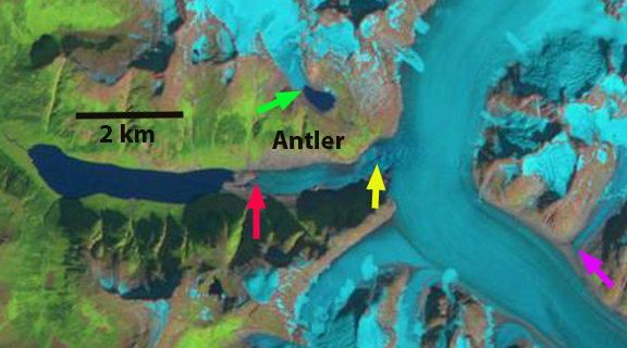
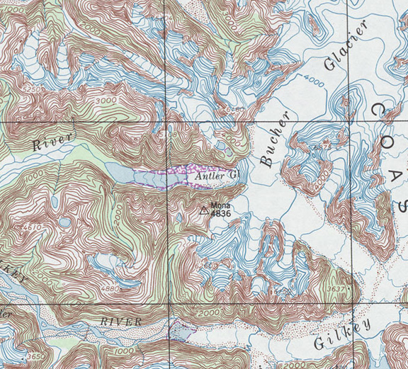
“What is wrong with this map?” . Was my first comment about the Antler Glacier in 1981, while surveying the geology in the region with the Juneau Icefield Research Program, during light snow flurries in August. The map I had was the most up to date USGS topographic map based on 1948 images, indicating Antler Glacier terminating in a small lake. By 1981 the lake was quite long and the glacier no longer reached it, though this was not perfectly evident through the snow flurries. If I returned to the same location today, looking at the updated USGS topographic map from 1979 my comment would be the same. Climate is changing our glaciers and our maps of these regions. The Antler Glacier is an outlet glacier of the Juneau Icefield. It is actually a distributary glacier of the Bucher Glacier. It splits from the Bucher Glacier 8.5 km above where the Bucher Glacier joins the Gilkey Glacier as a tributary. In 1948 it spilled over the lip of the Antler River valley from the Bucher Glacier and flowed 6 kilometers downvalley to end in a proglacial lake. The glacier was 6200 m long in 1948, red arrow is 1984 terminus, yellow arrow indicates 2014 terminus. Here we examine satellite imagery from 1984 to 2014 to identify changes in the Antler and other small glaciers in the area.
USGS map showing 1948 position of Antler Glacier.
Antler Glacier in 1979
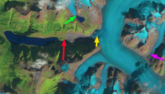
In each Landsat image the arrows indicate the same location, red arrow 1984 Antler Glacier terminus location, yellow arrow 2014 terminus of Antler Glacier, green arrow small glacier adjacent to Antler Glacier and purple arrow tributary glacier to Antler glacier. In 1984 Antler Glacier no longer reached Antler Lake which had expanded from a length of 1.6 km in 1948 to 4.2 km. The glacier was still 2.7 km long. Though I was in the area in 1984 I did not see Antler Glacier. The small glacier at the green arrow terminated at the edge of a small lake. The tributary at the purple arrow joined the Bucher Glacier. By 1997 the lower 2 km of the Antler Glacier were gone and the glacier ended near the base of the steep eastern entrance to the valley. The glacier at the green arrow no longer reached the lake and at the purple arrow the tributary has separated from Bucher Glacier. By 2013 Antler Glacier extended only 400-500 m over the lip of the valley entrance from Bucher Glacier. The glacier at the purple arrow was separated by more than a kilometer from the Bucher Glacier. There is little change of course from 2013 to 2014, Antler Glacier has retreated 2.2 km since 1984 and 5.8 km since 1948. The small glacier at the green arrow has receded 300 m from the lake shore. The former Bucher tributary at the purple arrow now terminates 1.4 km from Bucher Glacier.
The lake is gorgeous, and the valley once filled by the glacier is now nearly devoid of glacier input. The retreat is largely a result of reduced flow from the thinning Bucher Glacier which no longer spills over the valley lip significantly. As the Bucher Glacier continues to thin, the Antler Glacier will cease to exist. This thinning is due to increased ablation of the glacier. The mass balance loss at nearby Lemon Creek Glacier from 1953-2011 was -26.6 m Pelto et al (2013), this equals a thinning of at least 29 m. Gilkey Glacier which is fed by Bucher Glacier has retreated 3.2 km from 1984-2013 and 4 km from 1948-2013 (Pelto, 2013). Continued losses and separation of tributaries from the Bucher Glacier could lead to formation of glacier dammed lakes such as on Tulsequah Glacier. The Juneau Icefield Research Program directed by Jeff Kavanaugh will again be in the field in 2015., I will be interested to see their observations after the exceptionally warm but wet winter in the regione
1984 Landsat image
1997Landsat image
2013 Landsat image
2014 Landsat image


 Dean of Academic Affairs at Nichols College and Professor of Environmental Science at Nichols College in Massachusetts since 1989. Glaciologist directing the North Cascade Glacier Climate Project since 1984. This project monitors the mass balance and behavior of more glaciers than any other in North America.