
March 10, 2015
Cordillera Lago General Carrera Glacier Retreat, Chile
Posted by Mauri Pelto
You know southern Chile has lots of glaciers when an icefield with an area of 132 square kilometers has no named glaciers. Davies and Glasser (2012) referred to this icefield as Cordillera Lago General Carrera, since it drains into that lake, the icefield is just east of the Northern Patagonia Icefield. Davies and Glasser (2012) noted that the icefield has a mean elevation of 1670 m and has declined from an area of 190 square kilometers in 1870, to 139 square kilometers in 1986, and 132 square kilometers in 2011. They further noted that the area loss of Patagonia glaciers has been most rapid from 2001 to 2011. Paul and Molg (2014) observed a more rapid retreat of 25% total area lost from glaciers in northern Patagonia from 1985-2011, the study area was north of the Northern Patagonia Icefield. Lago General Carrera drains into the Baker River, which is fed by most glaciers on the east side of the Northern Patagonia Icefield. This river had a series of proposed hydropower projects that have now been cancelled by the Chilean government.

Here we examine Landsat imagery from 1987 to 2014 to identify the changes in a pair of outlet glaciers that drain the eastern side of the icefield, images below. In 1987 both outlet glaciers terminated in an unnamed lake that drains into the Leones River. The southern glacier is 5.5 km long beginning at 2400 m and terminates at the yellow arrow, with the snowline marked by purple dots, in the images below. The northern glacier is 5.0 km long beginning at 2200 m with the terminus at the red arrow. In 1987 the glaciers were in shallow enough water that calving was limited and no icebergs are evident. By 2001 both glaciers are no longer terminating in the lake. The retreat can no longer be enhanced by calving into the lake. By 2014 both glaciers have retreated several hundred meters from the lake. It is easier to measure the retreat in the 2013 Google Earth image. The retreat from the 1987 to 2013 position are indicated by the pair of arrows. The northern glacier has retreated 400 m and the southern glacier 600 m from 1987 to 2013. In both cases this is approximately 10% of the glacier length. The beautiful green color of the lake is indicative of the contribution of glacier flour from actively moving and eroding glaciers. This glaciers retreat is similar to that of the nearby Nef Glacier and Verde Glacier.
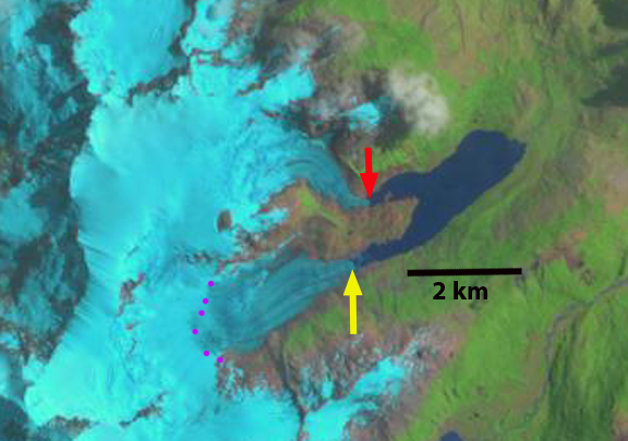
1987 Landsat image
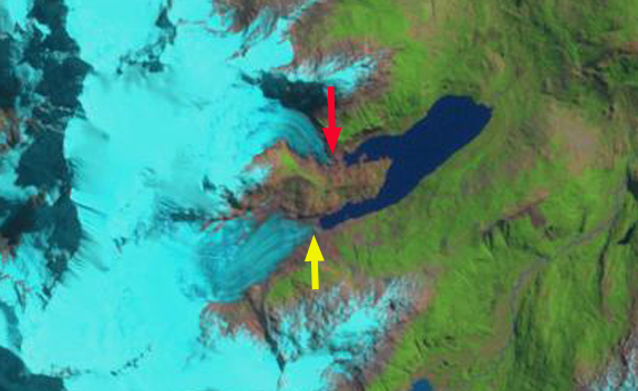
2001 Landsat image
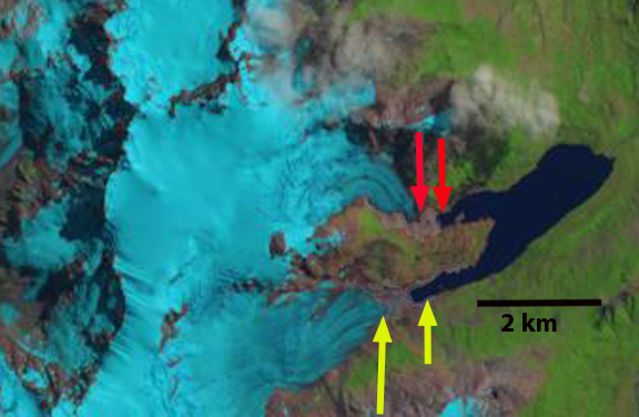
2014 Landsat image
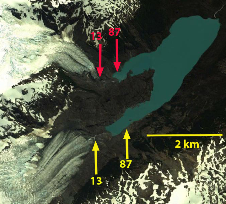
2013 Google Earth image. With arrows indicating terminus change from 1987 to 2013.
 Dean of Academic Affairs at Nichols College and Professor of Environmental Science at Nichols College in Massachusetts since 1989. Glaciologist directing the North Cascade Glacier Climate Project since 1984. This project monitors the mass balance and behavior of more glaciers than any other in North America.