5 February 2012
North America’s Missing Winter Turns Up In Europe!
Posted by Dan Satterfield
While the U.S. and Canada continue to look for a winter that has yet to arrive, it seems that the cold and snow have shown up across the pond in Europe. The BBC is reporting that temps dropped to -38 ºC in the Ukraine overnight, and there are deaths from the cold being reported across Europe. Another BBC report says the famed canals in Venice are starting to freeze over, while heavy snow began falling in London at dark Saturday. Heathrow Airport has canceled at least one-third of the Sunday flight schedule, and parts of Germany are already looking at temps. in the single digits on the old Fahrenheit scale.

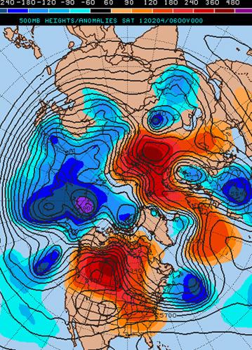
Red (blue) areas show where the atmosphere is warmer (colder) than normal. Image from Penn. State Weather E-wall.
Here in North America, the incredibly mild weather continues, with temperatures running 10ºC above normal or more over much of the U.S. and closer to 20ºC above in parts of Canada! What is happening here is fascinating, and it’s also an opportunity to tackle some common questions about weather and climate. The pattern of cold and warm air across the Northern Hemisphere is highly unusual right now, but the causes are not the result of just one cause, but many.
The 500 millibar chart shows a huge ridge of warm air over Canada and North America, with areas of cold air over Northern Russia and Western Europe. Moreover, this pattern has shifted very little over the past few weeks and it looks like it may not shift much for the next week or two. Long range numerical models are actually showing that Europe may be about to get a LOT of snow over the next ten days, while the U.S. stays fairly mild.
How much of this crazy weather pattern is due to climate change is a big question, and it is one that every forecaster gets these days. I just wrote a piece on this for NCAR’s Currents and I will link to that here when it comes out.
Dr. Jennifer Francis at Rutgers Univ. has been doing some ground breaking research into just this. She has found compelling evidence that the lack of Arctic Sea ice has caused a shift in weather patterns that could (at least in part) explain this kind of pattern. I saw her presentation in Breckenridge a few weeks ago (at the Glen Gerberg Weather and Climate Summit.)
You can see it as well below. Her power points are here (thanks to Dave Jones at StormCenter Comms.)
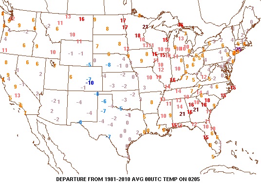
Take a look at how warm the U.S. is as of 7PM NY time Saturday night. Duluth in Minnesota is 21 degrees above the average temp. for 7 PM EST on 4 February.

Red numbers indicate the departure from normal in ºF for 7 PM, on Feb. 4th. Image from Penn. State weather E-Wall.


 Dan Satterfield has worked as an on air meteorologist for 32 years in Oklahoma, Florida and Alabama. Forecasting weather is Dan's job, but all of Earth Science is his passion. This journal is where Dan writes about things he has too little time for on air. Dan blogs about peer-reviewed Earth science for Junior High level audiences and up.