
29 December 2010
New York and London Shiver In The Snow; Put The Blame On the NAO!
Posted by Dan Satterfield
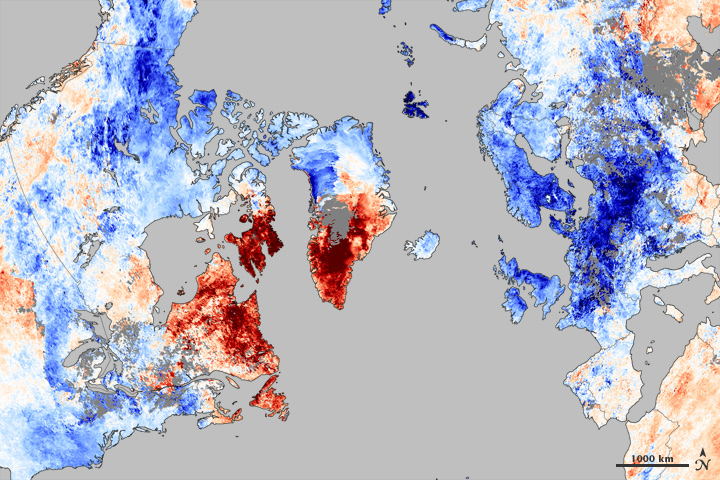
Take a look at the image below. It shows the temperatures relative to normal over the Northern Hemisphere the first week of December. It’s from NASA, and based on data from the Aqua satellite.
The NAO in it's negative phase brings unusual warmth to Greenland and Eastern and NE Canada. While the inuits bask in mild air, the big cities of Europe and America shiver.
The cold in the Eastern USA and in Europe is offset by incredible warmth in Greenland. Any meteorologist worth his salt will immediately recognize this as a highly negative North Atlantic Oscillation. I wrote about the NAO a few days ago here.
If you are unfamiliar with the NAO read that post first. It will give you a much better appreciation of the rest of this post.
This opposite phase of the NAO developed last winter as well. The folks in Washington, D.C. had their snowiest winter in living memory. Some piles of snow did not melt until May! Europe had heavy snow as well.
Now, look at the 500mb heights for the month of December from NOAA’s Climate Prediction Center. The NAO has been locked in a deeply negative state all month long. The UK had the coldest December since reliable records began over a century ago!
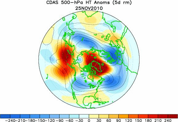
This animation shows the height of the 500mb pressure level. The higher you have to go to get to 500 mb, the warmer the atmosphere below it is. You can infer warm air in the red and colder than normal in the blue areas. The deeply negative NAO is marked by the incredible warmth over Greenland and NE Canada. A strongly negative NAO usually produces warmth west of Alaska in addition to the cold lobes in Europe and America.
This is truly an amazing image. It explains why it’s been a December to remember. This is why I woke up to 7 inches of snow Christmas morning; In Huntsville, Alabama no less!
Every time there is a big cold snap or snowstorm, climate researchers and even we meteorologists who forecast the day to day weather, get the same type of email. Usually it’s something along the lines of “What happened to global warming?” My usual response is that the planet’s temperature is not measured in your back yard. It’s measured in EVERY back yard.
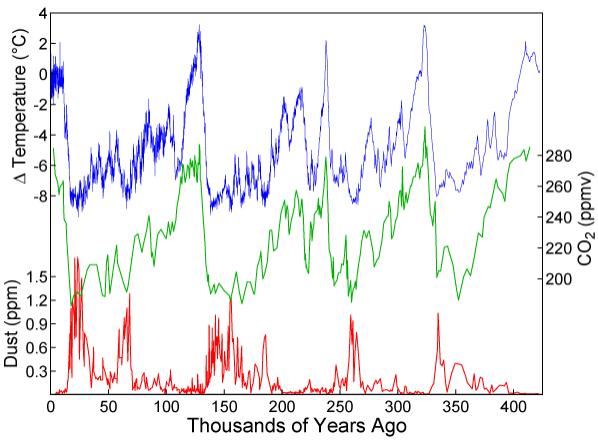
CO2 and temperature rise and fall together. This data from Antarctic ice cores.
Let me digress, and answer this question a bit better first before telling you about the real science going on.
The truth of the matter is that the planet is very warm right now. 2010 will either be the warmest year on record or very close to it. You can even argue that there may have been more snow in December because the atmosphere is holding about 4% more moisture than a century ago. (Warmer air can hold more water vapor)
On broad terms, if you double the CO2 in the atmosphere, the planet will warm. The physics says so, and every single time it has happened in the past, the planet got warmer.
In the past, the planet warmed up about 3.2 degrees C for a doubling of CO2. The best climate models today also indicate a number very near this amount. Scientists know of no good reason why it will be any different this time. The only difference is this. Instead of it happening over 100,000 years, it will happen in 300. That fact itself is the big problem.
End of my digression.
The real science question here is this. Is the strongly negative NAO related to climate change? Could rising greenhouse gases cause the NAO to go negative more often? This would mean colder winters in Europe, and Eastern America as the planet actually gets hotter! At the same time the sea ice in the Arctic will be melting away!
Sound crazy? It’s not.
There have been some serious investigations into this, and for the most part, it seems that model resolution is not good enough to give a definitive answer. Some evidence indicates a more positive NAO in a warmer world but other evidence is just the opposite. I have listed some of the papers published on this question at the bottom of this post.
No matter what the NAO does in a warmer would, just knowing what the NAO will do in winter could make for some very useful long range forecasts. The accuracy would be much better than now. It’s not an exaggeration to say that being able to predict a strongly negative NAO over winter would save governments and utilities many millions of dollars. Airports could prepare for heavy snow as well.
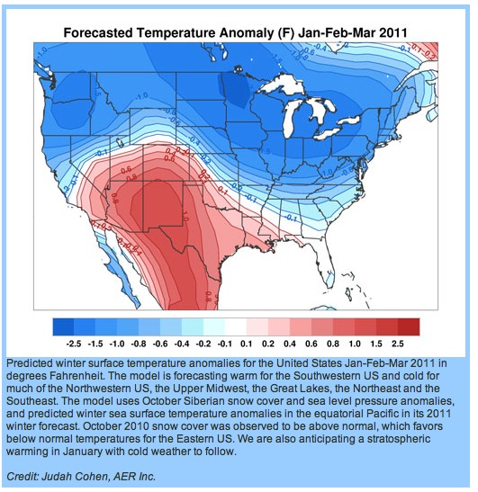
Cohen's forecast for North America over the next 3 months. This is an update from his earlier forecasts. If he is right, the break from the cold that is just now beginning will not last. Ctsy. NSF.
Andy Revkin’s Dot Earth blog has a great post about someone who may have discovered a link between autumn snow in Siberia and the following winter. Do read it.
Revkin notes that climate researcher Judah Cohen has had some very promising early results using his method of predicting the Northern Hemisphere winter. He has a summary of his research in plain non-science language here in the NY Times.
The correct question to ask scientifically in this case would seem to be: Is the extra fall snow in Siberia causing the negative NAO, or is the snow just the result of something else, and it’s that which is causing the NAO to tank?
Another good question is why is the fall snow in Siberia increasing? That one is easier. Less sea ice and the fact that it has warmed a lot in the high latitudes over the past 50 years. Remember that 4% I mentioned earlier?? The truth of the matter is that climate researchers are not very sure what effect the melting ice in the Arctic will be on weather patterns.
You might be wondering what Judah Cohen thinks will happen this winter. So far he is not too far off. On the right is his forecast for Jan.- Mar. courtesy the NSF. The NSF has a great summary of his work as well. A graphical summary of his methods along with his winter forecast is also available.
Climate expert Kevin Trenberth has a comment on Andy Revkin’s blog that is also IMHO spot on. He reminds us that the weather patterns on Earth are all the result of energy from the sun being moved about the planet. Since the VAST majority of that energy is locked in the tropical oceans. Any model or forecast that ignores the sea will have little skill.
For some of the papers on the NAO, start here. The sources at the end of the paper are a gold mine on the subject. Another paper ,with a different take is here. There are several other papers in journals. Many investigate how warming in the Arctic may cause unusual winters, by playing with the NAO, and it’s close cousin, the Arctic Oscillation.
Real climate also has a good post about cold winters and climate change. Also this:
Petoukhov, V., and V. A. Semenov (2010), A link between reduced Barents-Kara sea ice and cold winter extremes over northern continents, J. Geophys. Res., 115, D21111 [doi:10.1029/2009JD013568]. A summary of which is here.
The long and short of it is this. That human activity is warming the Earth is now a scientific fact. The details of just how it will happen in terms of weather at any one spot is a very complicated question.
It will almost certainly have some major surprises for us. Some may be just the opposite of what one would initially expect. That’s what makes scientific discovery so fascinating, and in the case of climate change, very critical.
In a way, this illustrates the very dangerous experiment we are conducting with the Earth’s climate. How to solve it, I don’t know. We’d better start finding out though.
Hopefully, you now realize just how silly those emails asking “what happened to global warming” really sound.
 Dan Satterfield has worked as an on air meteorologist for 32 years in Oklahoma, Florida and Alabama. Forecasting weather is Dan's job, but all of Earth Science is his passion. This journal is where Dan writes about things he has too little time for on air. Dan blogs about peer-reviewed Earth science for Junior High level audiences and up.
Dan,
Just read Cohen’s article. Very interesting! If he is right, we’re going to have a cold winter. If I understood the article, it looks like a brief warm-up(normal) in January then below normal for most of the winter??? Really interesting blog page.
Jarrod
Seems that way doesn’t it! I remain properly skeptical!
You and I know that unseasonably cold regional temperatures in Western Europe and North America don’t change the fact that the planet as a whole is unseasonably warm. But I suspect we won’t convince anyone else of that by berating them for their “silliness”.
Well made point Dan. I should have written it more carefully. The idea is silly in a scientific sense, but the incorrect belief is common until one thinks about it.
That said the claim is repeated everywhere by people who have been shown that it’s silly. I’m not sure what you call that.
[…] A moderate El Nino in 2010 combined with a strongly negative NAO (pressure pattern in the Atlantic) to produce extreme cold and snow along the Eastern Seaboard from here on Delmarva, […]
[…] on Delmarva, we do feel the impacts of El Nino, but other pressure patterns have far more influence on our winter weather, and these are not as predictable as El Nino is! […]
[…] read his weekly blog posts about his research/ forecasts here. I wrote more about Cohen and the NAO in 2010 in this journal, and if you’re wondering how snow in Eurasia could influence our winter in America, remember […]