10 April 2014
Mapping fantasy: The story behind the Game of Thrones geologic maps
Posted by mcadams

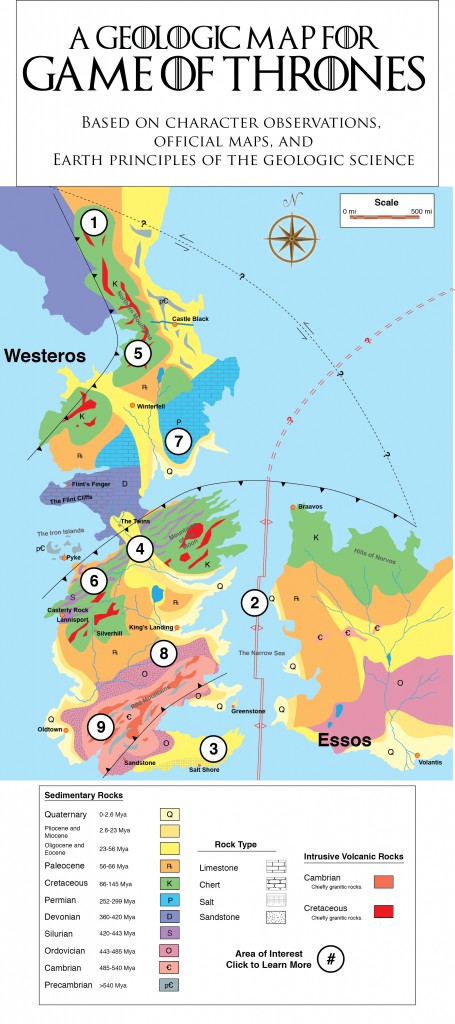
Miles Traer, a multimedia innovations producer at Stanford University’s School of Earth Sciences (and self-proclaimed Game of Thrones nerd), indulged in his pet project to create scientifically-rigorous geologic maps of the Game of Thrones fantasy world using real science principles learned throughout his academic career. Image by Miles Traer.
By Mike Osborne
Science fiction can be a really cool gateway for sharing science fact. Earth science is imaginative, and can draw on pop culture, like the HBO show Game of Thrones. My graduate school friend and Generation Anthropocene co-producer, Miles Traer, recently brought science fact and science fiction together over this show in a hilariously awesome and super fun project.
Traer noticed that the two continents in the Game of Thrones world – Westeros and Essos – fit together like a jigsaw puzzle. It reminded him of the way Africa and North and South America fit together, suggesting continental drift and the presence of plate tectonics in the fantasy HBO realm.
From that inkling, Traer, a multimedia innovations producer at Stanford University’s School of Earth Sciences, got a cool idea – to create Game of Thrones geologic maps.
“I took the main continent of the story, Westeros, and I decided to use little bits of information from the books, from the observations of the characters, from official maps, and a few other details to create a geologic map,” Traer said.
Fans of the HBO TV show, currently in its fourth season, are familiar with the Game of Thrones landscape from the show’s opening credits. And, like a lot of fantasy stories, the Game of Thrones books contain maps of the imaginary world. So putting together a map was a matter of doing a little detective work and applying some core principles of geology (albeit in the most rigorous way possible).
Traer scoured the Game of Thrones books for clues, studying the orientation of mountain ranges, extrapolating information from town names, and even noting the types of rocks characters used to construct castles. At every turn he was able to draw upon analogies from here on Earth.
“We know there’s granite in Winterfell,” Traer said. “We also know that there’s hot springs there, which fits in with this idea of plate tectonics … There’s [a town] called the Salt Shore, which I interpret to be actual salt deposits.”
The result is a “present day” map that is both detailed and scientific, and can help make geology relevant to fans of the show.
Traer also posted a series of maps covering the history of Game of Thrones geology, linking to each map further down in the post in a geologic timeline that parallels the Earth’s.
Traer drew from the Earth’s climate history to deduce the significance of the phrase “Winter is coming,” a remark often made by characters that, to a geologist, may indicate a climate shift rather than a change of seasons. Perhaps, he thought, extensive glaciation – a long period of colder weather when glaciers grow – played a role in shaping the Game of Thrones landscape.

Traer, pictured above, recently earned his PhD studying the evolution of the seafloor (submarine geomorphology if you want to get technical) at Stanford. Photo courtesy of Miles Traer.
“There’s this region called the Mountains of the Moon, between King’s Landing and The Twins. There’s this curious gap in the middle of the mountains. It looks like it’s been eroded flat,” Traer said. The only thing that has enough power to create a flat area within the mountains is an ice sheet, he said. For an ice sheet to grow and extend that far south, the planet must have been generally colder at least once before. “That was something that I really wanted to consider, that yes, climate can change on this planet too,” Traer said.
Traer hopes his maps will inspire others to comment – and to iterate.
“If you can propose a completely different formation of Westeros, I would love to hear it. I would love to know what you think. Document your assumptions the way that I have and I would love to see it,” Traer said. He encourages people to create their own maps to share, and provide feedback via email at [email protected] or in comments on the Generation Anthropocene site.
As the Lannisters, Baratheons, Tyrells, Wildlings, and Kahleesi wrestle for control of the crown in Season 4, maybe viewers will have the chance to glean additional clues into the world of Westeros and Essos.
For more about how Traer researched the Game of Thrones geology, listen to the Generation Anthropocene podcast interview with Traer.
— Mike Osborne is a science content producer with Worldview at Stanford University. Osborne co-created the Generation Anthropocene podcast along with Traer, and was the 2013 AGU-sponsored AAAS Mass Media Science and Engineering Fellow.


 The Plainspoken Scientist is the science communication blog of AGU’s Sharing Science program. With this blog, we wish to showcase creative and effective science communication via multiple mediums and modes.
Fantastic !
Hmmm – the Iron Islands then? Ancient volcanic activity?
Sorry for double post. Of course we know the Dragons in Valyria were in volcanoes where the slaves toiled. The Doom and all – potentially what happened, though nobody really knows. (Maybe I’m missing that?)
I like the map. Although, i would add also the obsedian to the rock lithologies (dragon glass) that has been extracted from castely rock if i’m not mistaken! Jon Snow travelled all over from the north to be able to put his hands on them since they’re a super efficient weapon to kill the white walkers.
Of course it would enter into a new category in the legend: volcanic explosive rocks