
9 November 2023
Glacial geology of Discovery Park, Seattle
Posted by Callan Bentley
[Cross-posted at the STEMSEAS blog]
Prior to embarking on the R/V Thompson for the inaugural STEMseas2YC oceanographic transit, a group of my fellow two-year-college STEM faculty and I set out on a geological field trip. Seattle is glaciated territory, and the majority of the ground is underlain by glacial sediments of one sort or another. There’s surprisingly little bedrock!
 Whenever I travel someplace new, I want to explore the local geology, and this brief sojourn in Seattle was no different. As soon as it was decided that I was going on the STEMSEAS cruise, I started making inquiries with Seattle-based geologists about what was worth seeing. What would have been ideal is for one of them to offer to take me out to cool outcrops, so I could just learn and enjoy. Someone else could be in charge! But that didn’t happen, so I volunteered to run an excursion myself, with the caveat that I do not know my way around. Four of my fellow STEMSEAS cruise participants indicated an interest in joining, so now I was committed. I ruled out a few locations because of distance, and another because its outcrop was underwater at high tide. And indeed, the ~6 hour window I had to run the field trip coincided with high tide. Furthermore, when I actually arrived in Seattle, it was raining, and so that constrained the logistics even further.
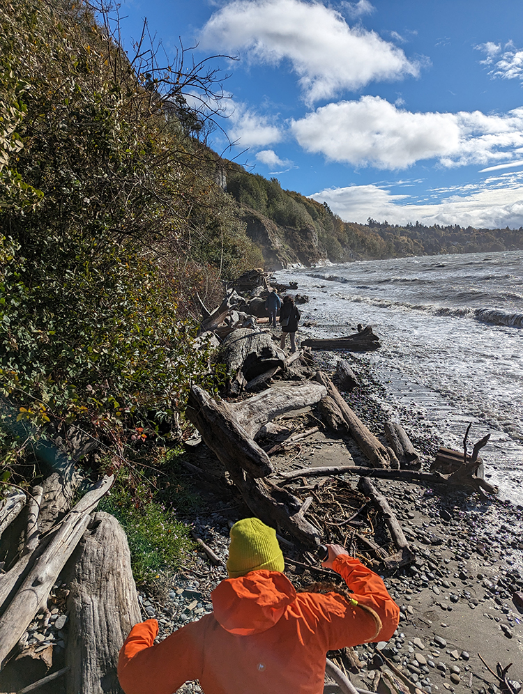
So: I settled on a 3 hour excursion to Discovery Park, a triangular promontory of land that pokes westward out into Puget Sound. What Discovery Park does well is glacial stratigraphy. I consulted several guides, most usefully J. Figge’s (2007) guide to the geology of the site.
Joining me were four of my STEMseas2YC colleagues: Rebecca Sperry (Salt Lake Community College), Kusali Gamage (Austin Community College), Karen Menge (Delgado Community College) and Tess Weathers (Chabot College). We took Lyfts to Discovery Park, and met up at the lighthouse at its westernmost point, then worked our way along the bluffs at South Beach to see the strata exposed there.
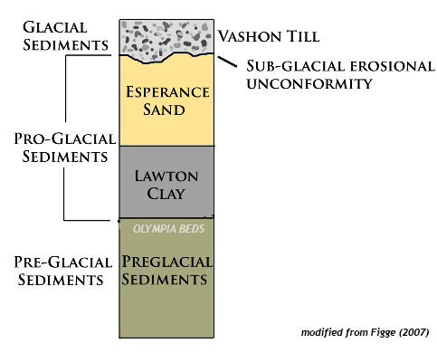
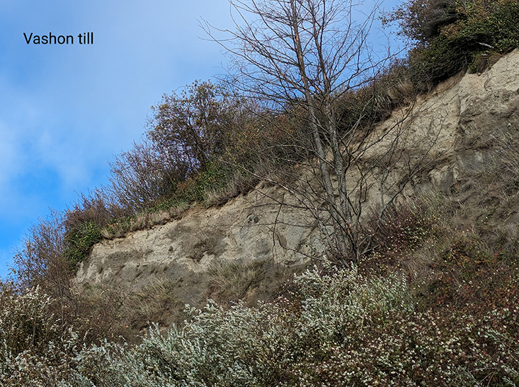
We encountered three stratigraphic units. From youngest (uppermost) to oldest (lowermost), which is the order we encountered them, they were: the Vashon Till, The Esperance Sand, and the Lawton Clay. All tell different aspects of the glacial story in Puget Sound. Further downsection (and to the southeast along the bluff) is another unit, the preglacial Olympia Beds, but we were not able to see these on our field trip due to beach access being swamped by the tide.
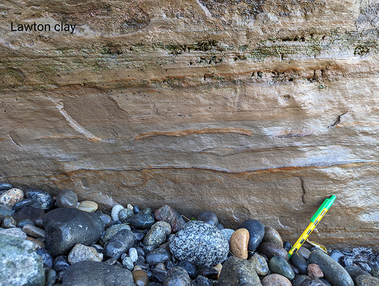
Honestly, I was delighted that we were able to examine three of the units in decent detail, and further pleased that they told a coherent story. The preglacial sediments of the Olympia beds record rivers and floodplains, and then these were swamped by a proglacial lake, Glacial Lake Russell, which stilled the depositional environment dramatically. The idea here is that the Puget Sound region was a lowland, into which first rivers, and then glaciers, drained. At first, the Puget Lobe of glacial ice pushed its way south into the topographic basin, blocking the shortest route to the sea. But rivers kept flowing, and so water backed up behind the dam-like obstacle of the glacial terminus. Conformably, the sedimentary sequence shifts from the Olympia Beds to the overlying Lawton Clay as water levels got deeper, and more still. In these calm waters, clay and silt were deposited, perhaps at rates up to an inch per year. These lake sediments comprise the Lawton Clay.
Overlying the Lawton Clay is a unit called the Esperance Sand. It’s orange and sandy, as the name implies. The sand is still interpreted as proglacial sediment, but now it’s a return to higher energy levels associated with prograding (advancing) outwash streams, ultimately derived from the glacial front. I didn’t get any photos of it, unfortunately. Oops.
Overlying the Esperance Sand is what really drew me to Discovery Park: a nice exposure of till. The Vashon Till was deposited directly by the Puget Lobe of the Cordilleran ice sheet. Poorly-sorted till is a signature that “glaciers used to sit right here.”
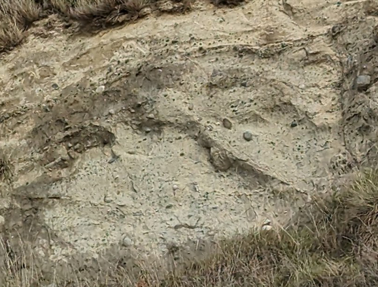
A close-up of the till’s texture:
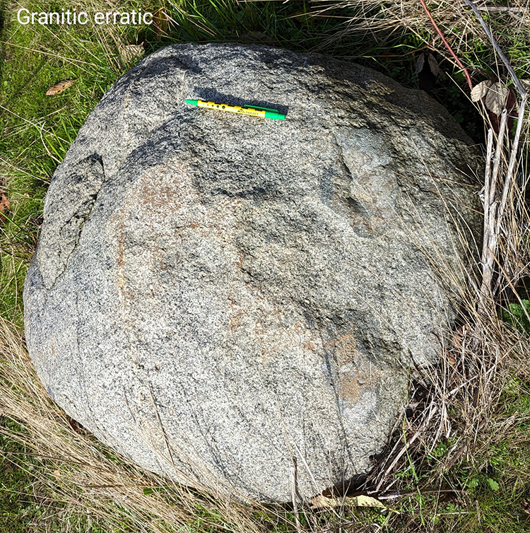 And down on the bench just above beach level, we found a lovely granitic glacial erratic. This was presumably weathered out of the Vashon Till, and may have experienced some post-glacial spheroidal weathering. It was easily the biggest boulder we saw, about a meter across. Furthermore, a detailed look at the erratic showed the presence of microgranular mafic enclaves (MMEs) within the granite, evidence of magma mingling at depth underneath a volcanic arc in the deep time past. Later, uplift and erosion brought these mid-crustal rocks to Earth’s surface, probably in British Columbia, Canada, and then a glacier chewed into them, plucking out a massive chunk and transporting it southward. It crossed the U.S./Canada border without a passport, and was dumped along with gazillions of other sedimentary particles of every size imaginable. When wave erosion milled away at the base of the Discovery Park bluffs, blocks of till dropped down in landslides, which were then sorted through by rain and waves. Smaller particles were stripped away, and larger ones were left behind. If you infer that because of its massive size, this erratic is also quite heavy and therefore unlikely to move far by watery means alone, that suggests it’s probably not too far from where the glacier left it ~18,000 years ago! It’s just that the surrounding finer-grained sediment has been stripped away in the interim.
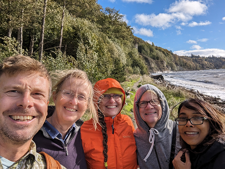
As you can see from the photos above, the rain stopped and the sun shone. It was pretty windy, but we all really enjoyed the outing.
Reflecting on the field trip now, after almost a week at sea, I ponder the nature of expertise.
I’m not a Seattle-area geologist, nor a glacial geologist. But I knew enough to enthusiastically and humbly share some understanding with my colleagues, who included an oceanographer, an engineer, a geophysicist, and a cell biologist. I felt gratified that we got decent weather and that I was able to be useful in interpreting the geology of this place I’d never previously visited.
Now we are all literally at sea, and that means I am figuratively at sea. I’m learning so much about stuff I haven’t thought about for a long time, or in same cases, ever. For instance, I’m working on a project focused on plankton, but I don’t know my globeriginid forams from my cyclopoid copepods. There’s a steep learning curve, but it’s fascinating. It’s humbling and grounding to realize how much I don’t know about seafloor topography, oceanic circulation, the physical characteristics of seawater, and the tools we use to explore the vast realm of Earth’s oceans.
One of the great strengths of the STEMSEAS program is that its goal is to help nurture student growth in the unique setting of an oceanographic vessel. The program helps build science identity in students by giving them learning experiences, but embracing the fact that none of us knows it all. Oceanography applies so many different scientific disciplines to stretching our understanding of the ocean. STEMSEAS students learn and grow, and I think that’s true for STEMSEAS mentors, too!
Resources:
Ralph Dawes’ website on Discovery Park
J. Figge (2007) guide to the geology of Discovery Park
 Callan Bentley is Associate Professor of Geology at Piedmont Virginia Community College in Charlottesville, Virginia. He is a Fellow of the Geological Society of America. For his work on this blog, the National Association of Geoscience Teachers recognized him with the James Shea Award. He has also won the Outstanding Faculty Award from the State Council on Higher Education in Virginia, and the Biggs Award for Excellence in Geoscience Teaching from the Geoscience Education Division of the Geological Society of America. In previous years, Callan served as a contributing editor at EARTH magazine, President of the Geological Society of Washington and President the Geo2YC division of NAGT.
Beautiful picture of the Lawton Clay and varied looses pebbles at the base.
I look forward to reading more about your STEMSEAS2YC adventures!
This is so great I feel like I am on the trip with you, thank you 🙂
Callan and colleagues: as a Seattle geologist I’m delighted that you visited Discovery Park. And had a sunny day to enjoy it. I’m pretty sure that my house is built on Vashon Till, as are many in Seattle. The Lawton Clay is the bad actor. Not far south of where you were in a district called Magnolia, landslides slipping on the clay have sent some large houses that formerly had expansive views over Puget Sound to the west to their demise.