
31 May 2019
Friday fold: Point Arena, California
Posted by Callan Bentley
It’s Friday, and I’m grateful that Bret Leslie of the NRC has stepped up with a Friday fold contribution from coastal California:
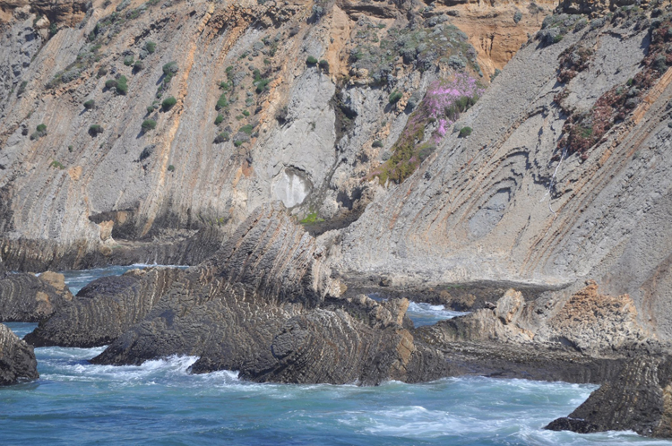
Bret says this outcrop is:
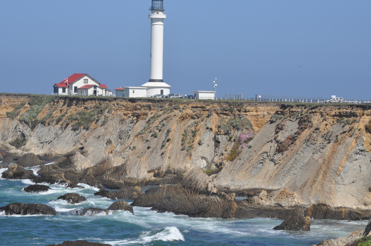
from my trip last month to the Sonoma and Mendocino coast. The first is the cliff below the Pt. Arena lighthouse. The marine deposits (now a marine terrace) are unconformably on top of the folded Miocene sedimentary rocks in the second photo.
Here is that second photo, showing the larger context and the angular unconformity:
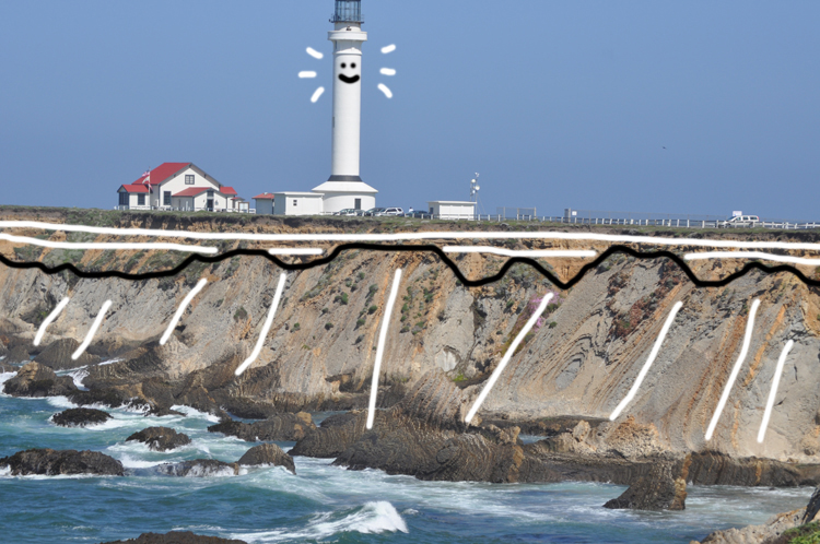
Whimsically annotated: bedding traced out in white, with the unconformity trace shown in black:
Shaw (2007) writes that:
Subunit 11: At Point Arena, Miocene marine deposits dip gently seaward and are overlain by thin Quaternary terrace deposits. … Point Arena is three miles west of where the San Andreas Fault passes northwestward into the Pacific Ocean. Rocks to the east of the fault belong to the North American Plate and those to the west, including Point Arena, belong to the Pacific Plate. … Lower Miocene strata are exposed in cliffs that line the coast from Point Arena southward. The rocks consist of light tan colored … foraminiferal clay shales, some bituminous sandstone and cherty shales. All have a high percentage of microscopic porosity, causing the bulk rock to have a very low density. … In places, flame structures are found, indicating soft sediment deformation in which the weight of overlying beds pressurize water in the fine layers and mobilize them to move as fluids and intrude upward into stronger shales. … The Miocene strata at Point Arena dip gently in some areas and are nearly vertical in others. Tight folding is indicated.
Bret recommends this road log if you visit the area.
One thing I’ll note is that the oval shapes (that are easiest to see in the first image) are not the traces of folded bedding, but just the outcrop pattern of erosion through upper bedding layers into deeper bedding layers – like the pattern of concentric rings you might see if you took an ice-cream scoop to the center of a stack of flapjacks. It’s the pattern you get when you impose a 3D outcrop surface on a more or less planar set of dipping 2D beds.
Pancakes and ice cream? Hmmmm: Sounds like weekend food. Enjoy your weekend!
___________________________________
Work cited:
Charles E. Shaw, July 2007. California Coastal National Monument Geologic Characterization. U. S. Department of the Interior, Bureau of Land Management. Downloaded 5/31/2019 from https://www.mendocino.edu/sites/default/files/ca_coastal_national_monument_geology.pdf
 Callan Bentley is Associate Professor of Geology at Piedmont Virginia Community College in Charlottesville, Virginia. He is a Fellow of the Geological Society of America. For his work on this blog, the National Association of Geoscience Teachers recognized him with the James Shea Award. He has also won the Outstanding Faculty Award from the State Council on Higher Education in Virginia, and the Biggs Award for Excellence in Geoscience Teaching from the Geoscience Education Division of the Geological Society of America. In previous years, Callan served as a contributing editor at EARTH magazine, President of the Geological Society of Washington and President the Geo2YC division of NAGT.