
3 September 2010
Friday fold: tight syncline in Montana
Posted by Callan Bentley
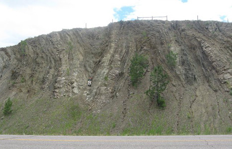
This fold is located on Highway 287, north of Wolf Creek, Montana.
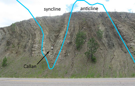
Annotated version:
As with last week’s Friday Fold, this fold owes its existence to (a) deposition of sandstone and shale in the Western Interior Seaway, and (b) deformation under a giant thrust sheet during the thin-skinned compressional tectonics of the Sevier Orogeny.
In this case, we’re south of the Lewis Thrust, and the local equivalent is called the Dorado Thrust. It’s basically the same exact thing you find up north in Glacier National Park: Mesoproterozoic Belt Supergroup metasedimentary rocks thrust as a relatively coherent sheet over weaker, younger Mesozoic sedimentary strata.
The fold is moderately plunging towards the road, which is how I was able to nestle in, tucked into the trough of the syncline, the length of my body parallel to the axis of the fold.
Happy Friday, everyone!
 Callan Bentley is Associate Professor of Geology at Piedmont Virginia Community College in Charlottesville, Virginia. He is a Fellow of the Geological Society of America. For his work on this blog, the National Association of Geoscience Teachers recognized him with the James Shea Award. He has also won the Outstanding Faculty Award from the State Council on Higher Education in Virginia, and the Biggs Award for Excellence in Geoscience Teaching from the Geoscience Education Division of the Geological Society of America. In previous years, Callan served as a contributing editor at EARTH magazine, President of the Geological Society of Washington and President the Geo2YC division of NAGT.