
20 March 2009
Lava domes, coffee, and a little bit of shaking
Posted by Jessica Ball
I’m finally back from my first attempt at field work in the volcanic highlands of Guatemala, and reasonably alive – no thanks to being laid out flat halfway through the trip by a truly nasty case of food poisoning. There is a distinct disadvantage to doing field work in a developing country, and it’s never more apparent than when you’re so sick you can’t eat for three days. However, aside from a major restructuring of our plan of attack, we were able to collect enough data to keep me busy until the next trip.
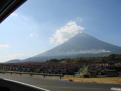
The first thing I noticed? Guatemala is FULL of volcanoes. It’s almost impossible to live somewhere on the Pacific coast where you can’t see one. Flying in was incredible – peak after peak went by the window, all beautiful symmetrical cones (except for ‘my’ volcano, of course, but that will come up later). There are more than twenty-five volcanoes (depending on how you count domes), twenty-two that have been active in the Holocene and at least ten in historical times. The capital city has a lovely view of its own stratovolcano, Agua, and Volcáns Fuego, Pacaya and Santa María are currently active.
 Volcán
Guatemala is an interesting place. It’s a developing country, which means that the infrastructure that a lot of us take for granted is much reduced, or even lacking. The government of Guatemala is still struggling to throw off a truly staggering atmosphere of corruption, which also extends to the judicial system and anything meant for infrastructure upkeep. As a result, the country doesn’t have much in the way of sanitation, which means that the first thing you notice is a lot of trash, everywhere. It’s a bit startling until you realize that most people hardly see it anymore. Most people get places by walking, or riding chicken buses – so-called because it’s not unusual to see farm animals on board, along with everything else.
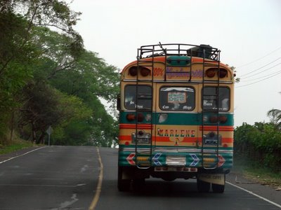 The “chicken bus” formerly known as Marlene. These are all old American school buses, painted over in really bright colors. Safety is definitely not a main concern, and the buses always get the right of way.
We mainly spent our time away from the capital (which is commonly referred to as Guate – confusing if you’re not sure whether the person is talking about the country or the city). The highland city of Quetzaltenango is about 150 km (or a 3-6 hour drive, depending on your route) away from Guate, and is also called Xela (pronounced Shay-la, short for Xelajú) after the old Mayan name. It’s a very popular place for gringoes to go and study Spanish, and has a charming central park (where I spent some time peoplewatching from a rooftop cafe). Parts of the city are actually quite beautiful – not very much of the actual old colonial architecture is left, since it gets destroyed by earthquakes every so often, but they’ve rebuilt in a sort of neo-Classical style here.
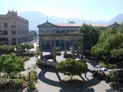 Parque Central, where everyone ends up at some point. This is early in the morning, before the vendors got down to business.
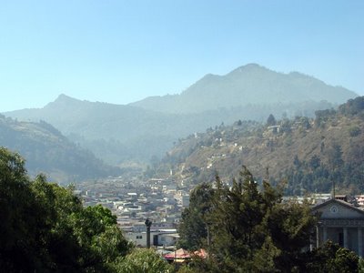 A view of some of the uphill parts of Xela, which is built in the middle of old lava dome complexes, debris avalanche deposits, and on the back slopes of Volcan Santa María. (The volcano is hidden behind the hills.)
While we were in Xela, we were (lucky?) enough to feel some fairly large earthquakes – a M4.9 about 80 km south of the city, and a M5.3 off the coast south of Guatemala City. One more geological experience for me – being woken up in the middle of the night by the bed shaking!


 Guatemala is unlike some other Central American countries (Costa Rica, for example) in that there are many more indigenous people still around, mainly in the highlands. Some of them have adopted the Westernized customs and dress of the Spanish-descended lowland populations, but many still wear traditional dress – mostly the women. They wear an amazing amount of color – in fact, I think they try to wear as much as possible at one time, with some truly eye-popping results. Women and children often carry loads on their heads – something I briefly tried in private, without much success – and it’s common to see a woman throw a folded cloth over her head instead of a hat. (These never fall off, and I couldn’t figure out why not.)
 Women in a parade for International Women’s Day (March 8). The ones on the right are doing the cloth thing.
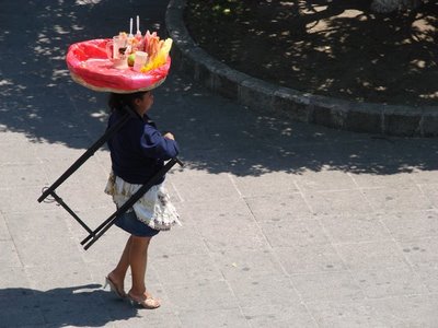 One of the street vendors with her basket. See the heels? Now imagine a little old lady wearing heels like that, and carrying a twenty-pound bag of flour on her head, and maybe a baby or two in a sling.
My research is centering around the lava dome complex of Santiaguito at the Volcán Santa María. The volcano and domes are just SW of Xela, in the middle of what are now coffee, banana and macadamia nut plantations (called fincas), and the whole lot sits at the head of several active river drainages that lead directly to the coast.
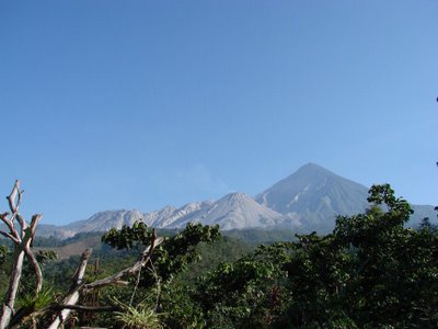 View of Volcán Santa María and the Santiaguito dome complex from the Santiaguito Observatory, about 3 km to the south.
Santa María first erupted in 1902, creating a huge Plinian column, extensive ash and tephra falls, and blowing a large crater in the flank of the volcano. (Possibly some slumping was also involved, although I’m not entirely sure.) Twenty years later, the first of the Santiaguito lava domes (Caliente) began growing in the crater. The lava domes have been growing ever since, migrating westward with time and eventually returning to the Caliente dome for the last twenty or so years. There have been several major dome collapses (one in 1929 that killed thousands of people and destroyed a number of the coffee plantations that drape the slopes below the domes), and many lahars, some of which destroyed the town of El Palmar in the late 1980s.
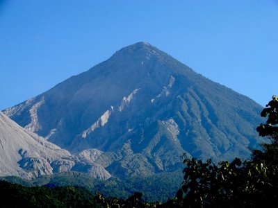 A closer view of the 1902 eruption crater, in which part of the dome complex sits (Caliente’s eastern slope is visible on the left). I’ve done a bit of fiddling with exposure and contrast on this one so you can see it better – the haze from crop burning obscures a lot at this time of year.
There has not, however, been a major dome collapse (involving more than the 3 million cubic meters of the 1929 collapse). My research is focusing on determining the probability of that happening, where it might occur, and what the runout distance of the debris could be. It combines structure mapping, investigations into the hydrothermal system of the domes, and computer simulations, and I eventually hope to turn it all into a new hazard map of the volcano. On this trip we weren’t able to actually make it out to the domes, but I did get to spend a lot of time observing eruptions – something that happens every few hours at Caliente, the active dome. It’s pretty exciting, but also really scary at times, since it makes you realize just how close thousands of people – and you – are to a very active volcano.
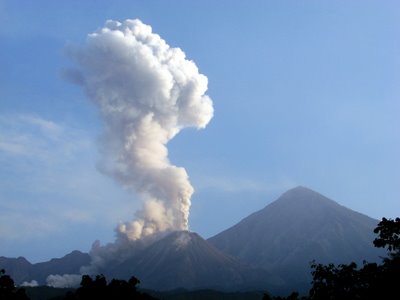 An eruption on March 15 that produced a moderately large pyroclastic flow (on the western flank of the Caliente dome). This turned into a large ash cloud that hung around for a while and even made it into the news, although it was by no means an indication of activity increasing dramatically.
Which brings me to a darker side of the work that I’m going to be doing. The populations of the fincas (coffee plantations) live in much the same way they did in 1929 – without paved roads, motorized vehicles, or much communication with people far beyond the local towns. There is probably no one left who remembers the ’29 event, and since nothing major has happened at the volcano since then, they have no way of conceiving of the magnitude of a major collapse event. Perhaps they understand the dangers, but what could they do to avoid them? There is no infrastructure that could initiate, organize or support a large-scale evacuation. Data from seismic stations and from the observatory is transmitted directly to the country’s geological survey, INSIVUMEH, in the capital, and it is by no means a large organization with the clout of, say, the USGS.
It’s a sobering thought. My work may help people in the future – in fact, I hope that it will help give the INSIVUMEH scientists the support they would need to convince people of the need for an evacuation – but it’s a very small chance. More likely is that a major dome collapse will someday happen, and people won’t be able to get away from it even if they have warning.
It’s a pity to end on a depressing note. In the next few posts I’ll talk a little bit about some of the thermal imaging we did with a FLIR (Forward-Looking InfraRed) camera, and show off more of the nifty images you see when you’re watching a volcano that erupts every few hours; I’ll also do a little tour of some of the areas below the volcano, and what happened there in the 20s and 80s.
 Jessica Ball is a volcanologist at the U.S. Geological Survey, researching volcanic hydrothermal systems and stability, and doing science communication for the California Volcano Observatory. She previously worked at the Geological Society of America's Washington DC Policy Office, learning about the intersection of Earth science and legislative affairs. Her Mendenhall postdoc and PhD focused on how water affects the stability of volcanoes, and involved both field investigations and numerical modeling applications. Her blogging covers a range of topics, from her experiences in academic geosciences to science outreach and communication to her field and lab work in volcanology.
Sweet project and field area! That chicken bus looks like it comes right out of “Romancing the Stone” (and what a fittingly geological movie title, to boot)!
Nice post, and very interesting countryside and people.
sounds like a great time. Enjoy riding the camionetas! Never mind the volcano being dangerous its the bus rides. Always guaranteed to shave a few years off your life expectancy.
It’s funny how much I’ve learned about people and places I didn’t even know existed just by reading geologists’ writings from the field. Here’s to hoping you’re able to help those people manage the risk from their local volcanoes.
Enjoyed reading your page. I just wanted to make a correction. The volcano that you referred to behind the planned community is actually the water (Agua)volcano, not the Pacaya as mentioned. The Pacaya would have been on your left side coming out of Guatemala City, before you would see the Agua on your right. The planned community is called Las Victorias. My family owns a vacation home there and love it. Yes we live on the edge and many tremors do occur there. At night sometimes when it is clear, we can see the Pacaya from the yard and its brillian lava flows and sparks. In 2007 we came back from vacation to have my 5 year old play ‘earthquake’ with my infant son. She would shake his baby swing with him in it. Look forward to reading more of your volcanic adventures!
Kimm – Thanks for the correction! I was trying to help navigate and look at volcanoes at the same time, and I kept getting confused. (There are a lot of volcanoes down there!)Wow, I didn’t know people had vacation homes down there. Actually, I would love to have one near a volcano, too, just so I could watch the lava flows.
[…] try to get a few more posts out this week, since I’m going to be in the land of sporadic internet access for the rest of the month. More on that […]