

2 July 2018
Guang’an: a dramatic retaining wall failure video
Guang’an: a dramatic retaining wall failure video
Youtube has a cool video showing the impact of a retaining wall failure in the city of Guang’an in Sichuan Province, China. The event reportedly occurred early in the morning yesterday (6:50 am on 1st July 2018):
.
The event reportedly involved the failure of a 50 m section of retaining wall during heavy rainfall. Interestingly, Liveleak has a second video that shows a part of the failure of the wall from the foot of the slope. This still is taken from that video:-

Retaining wall failure at Guang’an in Sichuan, China. Still from a video on Liveleak.
.
I am not quite sure what to make of the images from the videos of the state of the materials behind the unfailed sections of the wall after the failure:-

The aftermath of the retaining wall failure in Guang’an, Sichuan Province, China on 1st July 2018. Still from a video on Liveleak.
.
The resultant landslide was a classic slump, with the roadway moving downwards and outwards as the support at the toe of the slope failed. The Chengdu Economic Daily has an article about the landslide (in Mandarin). This article indicates that cracks had started to appear in the fill behind the wall on 22nd June, and that the authorities had been aware of the problem. These cracks enlarged rapidly on the day of the failure, such that local people were able to provide warnings that a failure night occur. The landslide occurred in several phases, starting at 6:50 am, and there was a significant failure at about 11 am too. In total about 50 households have now been evacuated. The slope was reportedly about 30 m in tall. Interestingly there is quite a large section of this wall that remains standing, as the still below shows:

The aftermath of the retaining wall failure at Guang’an in Sichuan, China. Still from a video on Youtube.
.
Managing the remaing sections of that wall will be challenge in the forthcoming rainy season.
29 June 2018
Lai Chau: multiple landslides in Vietnam in recent days
Lai Chau: multiple landslides in Vietnam in recent days
In the last few days heavy rainfall in Lai Chau in the north of Vietnam has triggered multiple landslides. The most impressive of these was captured on a video:-
.
The video shows that when the landslide occurred there were excavators working on the slope, one of which can be seen in the still below:-
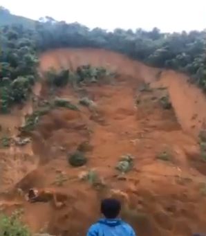
One of the landslides in Lai Chai, Vietnam, highlighting one of the two excavators that was caught up in the slide. Still from a Youtube video.
.
This article in Tuoi Tre News, which also has a video of the landslide from a different article, indicates that the driver of one of the excavators managed to escape his vehicle before the landslide, whilst the other went over the cliff with his machine. Remarkably he survived and was rescued:
Pham Van Sang and his colleague were using separate excavators to clear mud and rocks left from a recent landslide on a section of National Highway 12 in Sin Ho District, Lai Chau on Tuesday evening when a new mudslide sent a fresh wave of debris tumbling down a mountain flanking the road. While his colleague managed to evacuate his machine in time, Sang was still inside his excavator when it was pushed off a 50-meter-high cliff. After the fall, Sang managed to climb about three meters back up the cliff before passing out from fatigue.
He was later brought to the Lai Chau Province Hospital for emergency treatment. The victim suffered three broken ribs, injuries to two vertebrae and his cheekbone, and pulmonary effusion, doctors said, adding that they performed an emergency surgery to remove fluid from his lungs.
Others have been less fortunate. Reports suggest that these landslides and floods have killed at least 23 people. One of the most significant events occurred at Nam Ha in Sin Ho district, where a landslide swept through the village on 24th June. The image below shows the landslide; at least four people were killed:-
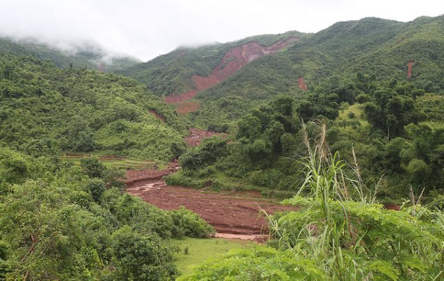
Ther landslide at Nam Ha in Lai Chau, Vietnam, which killed at least four people. Image from Voice of Vietnam.
.
Landslides are a growing menace in Vietnam in both mountainous areas and along rivers.
26 June 2018
Waioeka Gorge: a new landslide video from New Zealand
Waioeka Gorge: a new landslide video from New Zealand
On Sunday, a landslide occurred at Waioeka Gorge on State Highway 2, the main road between Gisborne and Rotorua in New Zealand. The landslide was captured on video by a motorist, Michael Tabudravu, who stopped when he saw debris on the road ahead of the main event. Stuff has a nice article about the event, in which they provide his description of the landslide:
About three other cars coming from the other direction had stopped to see what was going on, too. Some tried to manoeuvre around the debris and keep driving. The cliff face where the rock had come from was clearly unstable, Tabudravu said on Monday.
“I could see it started cracking underneath – this big crack…Then the whole thing just came down.”
By then most other drivers had left, heading back the same way they came. But Tabudravu whipped out his phone in time to record the face collapse into a wave of rubble.
“It’s not something you see every day…It was a bit of an adrenalin rush to be honest.”
.
The landslide appears to be a wedge failure (note the very clear rock mass discontinuity that defines the detachment zone on the opposite wall), with the rock mass showing rapid disintegration to flow down the gully:-
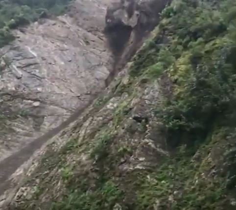
The rockslide at Waioeka Gorge in New Zealand. Still from a Youtube video shot by Michael Tabudravu.
.
There is also an interesting video on Youtube, posted by CCTV, showing a building collapse in Guangxi Zhuang Autonomous Region in China. The report suggests that this landslide occurred in Weijiagou Village, resulting in the collapse of over 20 houses and the evacuation of nearly 380 people:-
.
The video includes other landslides triggered by the heavy rainfall, including one that killed six people.
22 June 2018
A remarkable debris flow video from Ladakh
A remarkable debris flow video from Ladakh
A video has been posted on to Youtube in the last week that shows a remarkable debris flow from Ladakh in northern India. According to the text the video was taken at Nubra Ladakh. It seems that that Nubra is, in the words of Wikipedia:
“a tri-armed valley located to the north east of Ladakh valley. Diskit the capital of Nubra is about 150 km north from Leh town, the capital of Ladakh district, India. Local scholars say that its original name was Ldumra (the valley of flowers). The Shyok River meets the Nubra or Siachan River to form a large valley that separates the Ladakh and Karakoram Ranges. The Shyok river is a tributary of the Indus river. The average altitude of the valley is about 10,000 ft. i.e. 3048 metres above the sea level.”
.
The debris flow is clearly very high energy and high velocity:-
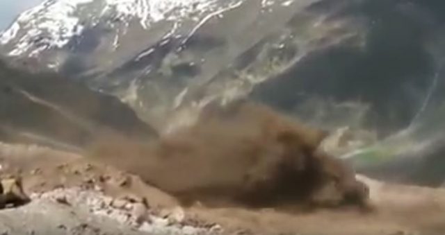
The debris flow at Nubra in northern India. Still from a Youtube video.
.
The exact location of this event is not clear, but the of the debris flow origin appears to be one of the glaciated valleys:-
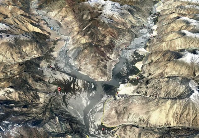
Google Earth image of the Nubra Valley in Ladakh, northern India.
.
The weather does not seem to indicate heavy rainfall, but this area is a high altitude desert in which rainfall is rare. The debris flow may be associated with a glacial event, such as a GLOF, or perhaps a localised cloudburst.
Back in 2010 the Ladakh region was hit by a very serious debris flow disaster, which killed at least 234 people, with up to a further 800 people reported to have been lost. There was a further significant event in this region is 2010, which caused substantial damage but claimed only two lives. In both cases the volume of rainfall was not large in global terms, but was exceptional for this region.
21 June 2018
Hidroituango: Renewed movement suggests a landslide of up to 200,000 cubic metres may occur soon
Hidroituango: Renewed movement suggests a landslide of up to 200,000 cubic metres may occur soon
News reports suggest that there is an increase in movement on the slopes above the lake at Hidroituango. This is being interpreted by those responsible for monitoring at the site as indicating that a landslide in the range of 100,000 to 200,000 m³ may occur in the next few days. RCN Radio reported last night that workers have now been evacuated from the site in anticipation of the slip. However, there has not been a need to trigger new evacuations of the communities downstream over and above the 2,500 families that remain in emergency shelters.
A landslide of up to 200,000 m³, whilst large, is not being considered as being sufficient to endanger the integrity of the dam, and nor is it expected to generate a wave of sufficient magnitude to trigger an overtopping event. In the last two weeks the level of the lake has dropped by seven metres as drier conditions affect the catchment. The reduced head of water has led to a decrease in the flow through the dam itself.
The image below shows a Planet Labs image collected yesterday (20th June 2018) of the Hidroituango dam site. The location of the anticipated landslide is not clear, but the reduced level of the lake is apparent:-
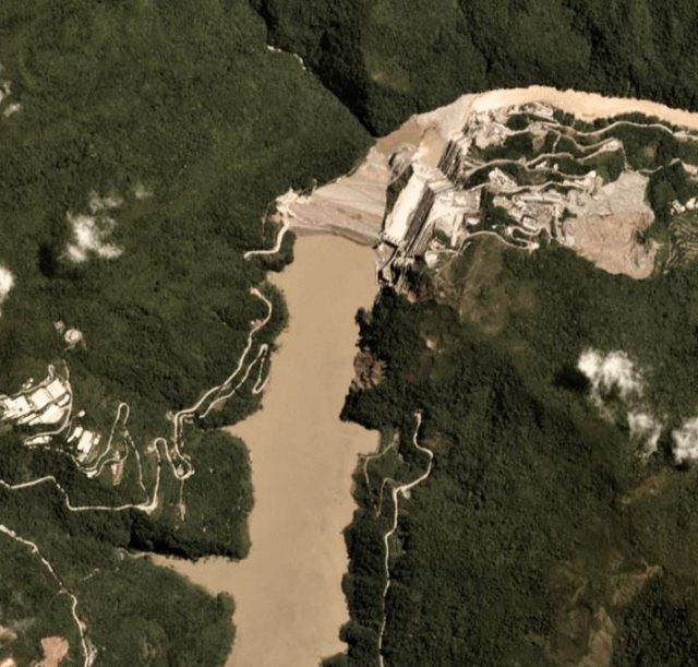
Planet Labs image of the Hidroituango dam site. Image collected on 20th June 2018, used with permission.
.
EPM now expects to bring the situation under control by October, allowing restoration works to begin to bring the site back to a state that provides complete control of the lake level, and ultimately that provides the capability to generate power. However, that is likely to require considerable work given the level of damage and the effects of the emergency works.
Reference
Planet Team (2017). Planet Application Program Interface: In Space for Life on Earth. San Francisco, CA. https://api.planet.com
19 June 2018
Mars: a landslide triggered by a small meteoroid impact
Mars: a landslide triggered by a small meteoroid impact
The University of Arizona has released a really interesting image of the aftermath of a meteoroid impact on Mars that triggered a comparatively long run out landslide:-

HiRISE image of a meteoroid impact crater on Mars, with its associated landslide deposit. Image via the University of Arizona.
.
The imagery was captured by the HiRISE instrument. The impact event is thought to have occurred about a decade ago. The meteoroid has created a crater with a diameter of about 5 m, and a more substantial impact debris field. The landslide appears to have initiated very close to the crater, but the crater itself remains intact:-

HiRISE image of the debris and landforms from the Mars impact event, and the associated landslide source. Image via the University of Arizona.
.
There is a good write-up of this in Universe Today:
In that time, the MRO has acted as a relay for other missions to send information back to Earth and provided a wealth of information of its own on the Red Planet. Most recently, it captured an image of an impact crater that caused a landslide, which left a long, dark streak along the crater wall. Such streaks are created when dry dust collapses down the edge of a Martian hill, leaving behind dark swaths.
In this respect, these avalanches are not unlike Recurring Slope Lineae (RSL), where seasonal dark streaks appear along slopes during warmer days on Mars. These are believed to be caused by either salt water flows or dry dust grains falling naturally. In this case, however, the dry dust on the slope was destabilized by the meteor’s impact, which exposed darker material beneath.
The impact that created the crater is believed to have happened about ten years ago. And while the crater itself (shown above) is only 5 meters (16.4 feet) across, the streak it resulted in is 1 kilometer (0.62 mi) long! The image also captured the faded scar of an old avalanche, which is visible to the side of the new dark streak.
In terms of morphology, this landslide is reminiscent of the rock avalanches flowing across ice, such as this example from Alaska:
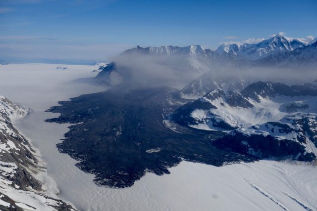
The Lamplugh Glacier rock avalanche via Paul Swanstrom.
.
It even has the distinctive digitate lobe structure seen at the toe of the landslide. The wonderful Mount Dixon rock avalanche video suggested that this structure can be formed by slow creep at the end of the main movement period.
18 June 2018
Hidroituango: a substantial step towards reducing the immediate risk
Hidroituango: a substantial step towards reducing the immediate risk
On Sunday a significant milestone was reached in the ongoing efforts to reduce the risks at the Hidroituango dam site in Colombia. Efforts have been ongoing to raise the crest of the dam, reducing the likelihood of it being overtopped by a wave triggered by the failure of the slopes around the lake. The first target was to reach 410 m, at which point the spillway became operational (should it be required). Yesterday the crest of the dam reached 415 m, providing considerable additional security.
The next target is 418 metres; the ultimate aim is to reach 435 metres.
The consequence of these improvements to the structure is that the level of warning has been reduced for a substantial part of the population living downstream from the dam. This improved dam safety, plus the decease of inflows as the mountains upstream from the dam move out of the rainy season, has allowed 11,000 people to move back. However, 4,000 people remain evacuated.
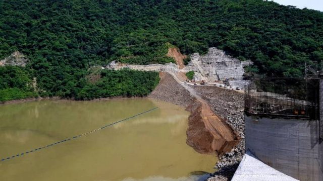
A recent image of the dam site at Hidroituango. Image from Caracol.com.co.
.
The image above shows he current state of the dam at Hidroituango. Note the very large volume of material tipped on the upstream face of the dam. This appears to be the material that is being used to try to reduce the leaks in the structure.
15 June 2018
Kilauea volcano: large-scale slumping on the rim of Halema‘uma‘u crater
Kilauea volcano: large-scale slumping on the rim of Halema‘uma‘u crater
The ongoing major eruptive event at Kilauea volcano in Hawaii has generated a wide range of spectacular videos and extensive news coverage. At the summit of Kilauea is the large Halema‘uma‘u crater, which has been undergoing major morphological changes in response to recent events. Most importantly, a little more than a month ago the lava lake that had occupied this space drained down. In response, the walls of the crater have undergone large-scale slumping. Volcanic landslides are well-documented, but rarely in this level of detail.
The USGS has a page that provides their latest photographs and videos of the Kilauea eruptive event, which includes remarkable imagery of these slumps. For example, this image shows the sequential curved tension cracks that mark the back of a series of large slumped blocks:-
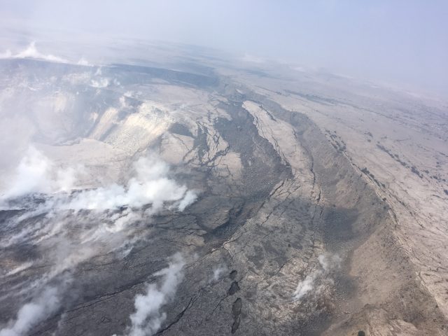
Cracking and slumping of the Halema‘uma‘u crater walls are clearly evident in this aerial view captured during HVO’s overflight of Kīlauea’s summit on 9th June 2018. Image from the USGS.
.
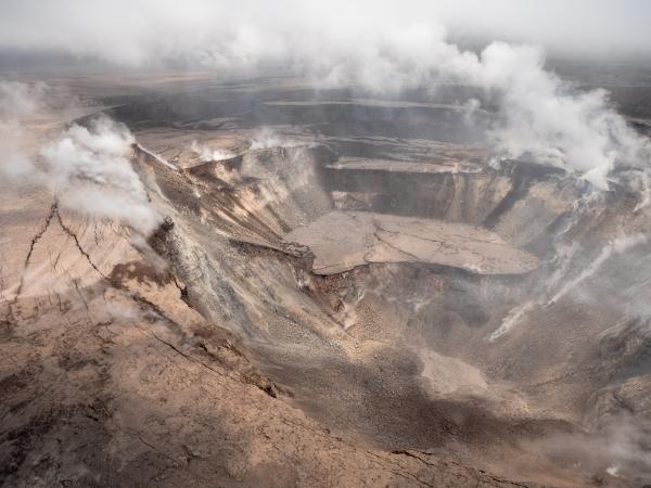
Whilst the image below gives a wider perspective view of this slumping process. In some cases the slumped blocks have deformed by over 100 metres:-
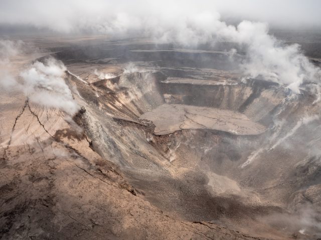
Slumped blocks at the Halema‘uma‘u crater. Image via the USGS, collected on 12th June 2018.
.
There is a wonderful drone video, collected this week, that provides a panoramic overview of the deformation.
This is a textbook case of slumping in response to changes in the local stress state. We see successive slump blocks like this in conventional landslides too, though rarely with such clarity. A very interesting element of this is the lack of rotation in the blocks, none of which appear to be backtilted. I wonder if this is because of the circular planform of the blocks (whereas in non-volcanic landslides they tend to have a more linear planform). Presumably this circular shape inhibits the development of rotation.
The USGS have been monitoring the development of these slumps at Kilauea, so in due course there should be some fantastic data on the ways in which these landslides evolve.
14 June 2018
Rattlesnake Ridge: new drone footage of the development of the landslide
Rattlesnake Ridge: new drone footage of the development of the landslide
The WADNR has released a good video, captured by a drone on 31st May, showing the development of the Rattlesnake Ridge landslide. This video is available on Youtube and should be embedded below:-
.
As expected by those responsible for monitoring the landslide, it has continued to creep over the last few months, and judging by the images it has now displaced by a few metres:-
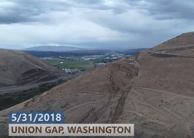
Displacement of the Rattlesnake Ridge landslide at Union Gap in Washington State. Still from a drone video released on Youtube by WADNR.
.
Note the displacement of the tracks across the landslide, which give a good indication of the total movement of this part of the landslide. The slide has now formed a very clear head scarp (actually a double scarp, which is not unusual):-
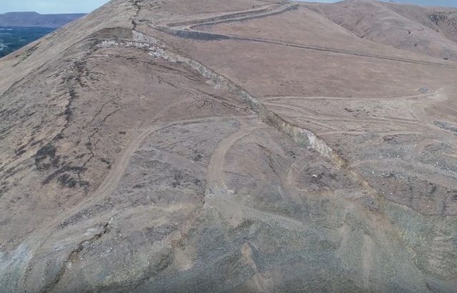
The double headscarp of the Rattlesnake Ridge landslide. Still from a drone video released on Youtube by WADNR.
.
The WADNR continue to monitor and manage the landslide, and they have a good website that provides details of their activities. I hope that in due course we will see a range of peer reviewed publications analysing the movement dataset that they are collecting.
12 June 2018
The Rohingya refugees: landslides start to take lives as the monsoon arrives
The Rohinghya refugees: landslides start to take lives as the monsoon arrives
For the last few months there has been increasing concern about the plight of many of the Rohingya refugees who have been forced out of Burma – Myanmar – by the military, and are now living in makeshift camps in Bangladesh. The numbers are vast – some estimates suggest over 700,000 people. There is particular concern about the camps at Kutupalong and the surrounding areas, which are thought to have a population that exceeds 500,000 people. The camps have been built on hilly, forested land that is highly susceptible to landslides. The trees have been felled to create space for the camps, and the makeshift accommodation has been built on and at foot of the slopes. Conditions are dire. CNN reports that Caroline Gluck, the spokesperson for the UNHCR, described the situation as:
“People are practically living on sandcastles”
The monsoon season has now arrived in Bangladesh. CNN also reports the first fatality of the rains (though not the first landslide fatality in the refugees camps this year):
“Around 2.30 a.m. Monday morning a mud wall in a shelter in the Kutupalong camp collapsed, killing a 3-year-old boy and injuring his mother”
Yesterday Nafeesa S tweeted a set of photographs of the conditions in the camps. For example, this image shows the weak state of the soil and the potential for collapse:
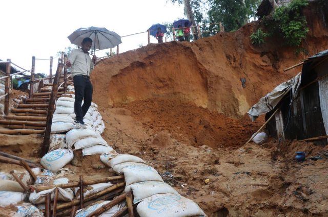
The weak soil at the Rohingya camps in Bangladesh. Image tweeted by Nafeesa S
.
Whilst this image shows the houses built on deforested, weak slopes in the refugee camps:-

Houses built on weak unstable slopes in the Rohingya camps, in Bangladesh. Image tweeted by Nafeesa S
.
As of yesterday 21 landslides have been reported Over the next few days heavy rains are expected in Bangladesh. News reports this morning suggest that 13 people were killed by landslides overnight, although it is unclear as to whether these are refugees or the local population (who are also very vulnerable to landslides). The NASA TRMM model for landslide susceptibility highlights this area as being at risk at present:

NASA TRMM model of real time landslide susceptibility, highlighting the high levels of hazard in the areas occupied by the Rohingya refugees at present.
.
The situation over the next few days is likely to be dire.
 Dave Petley is the Vice-Chancellor of the University of Hull in the United Kingdom. His blog provides commentary and analysis of landslide events occurring worldwide, including the landslides themselves, latest research, and conferences and meetings.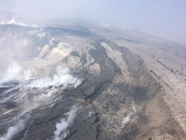
Recent Comments