
10 February 2010
Continuing works on the Attabad landslide
The National Disaster Management Authority in Pakistan is posting daily updates on the situation with the Attabad landslide on its website here. The reports appear with a lag of about 4 days, but nonetheless provide a helpful insight into the rate of progress. As of 6th Feb a total of 26,000 cubic metres of debris had been moved to create the spillway. Meanwhile the lake level is increasing at 60 cm per day – it will be interesting to see if this rate decreases with the recent weather.
This impressive rate of progress appears to be possible because the area that they are excavating is very fine-grained, as this video shows:
Meanwhile, the ever helpful Pamir Times reports that the river blockage is starting to have substantive impacts downstream due to the reduced flow levels. These impacts are clearly most acute directly below the dam, where the river is now dry, but extend right down to the Tarbela dam, close to Islamabad.
9 February 2010
Problems at the Hattian Bala landslide dam in Pakistan
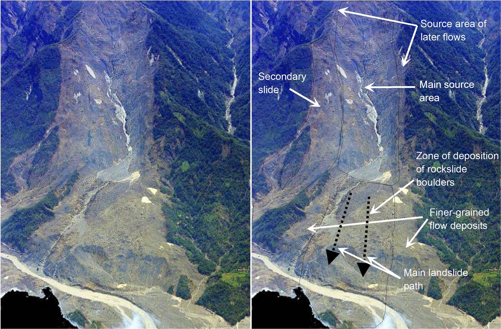
The largest landslide in the 2005 Kashmir earthquake occurred at Hattian, 25 km or so from Muzaffarabad:

My colleagues and I wrote a paper on this landslide a few years ago (you can download the pdf here). It was notable for the fact that it blocked the valley – in the aftermath the Pakistan Army built a spillway to ensure that uncontrolled overtopping did not occur. The landslide has been stable since, although many of us have warned that this area is far from out of the woods, with the first really intense precipitation event being a key test.
In the last few days this area has suffered a very heavy rain and snowfall event – as in fact has a vast area of the Himalayan Arc – indeed I have never seen a 1 day TRMM landslide potential map like this – it is quite bizarre:
 Late tonight, media sources in Pakistan are suggesting that the lake has broken its banks, flooding 23 houses. So far the dam is holding, but clearly this event will ask substantial questions of it. Hopefully, the spillway engineers have got this right!
Elsewhere in the Muzaffarabad area, heavy rain is reported to have triggered many landslides. I have not yet seen any reports of the situation at Attabad, but this is not likely to be helping.
7 February 2010
Mudslides occur in the areas affected by the 2009 Station Fire in Los Angeles
The Station Fire was a huge forest fire that occurred on the northern edge of Los Angeles in late 2009:It was finally brought under control on 16th October 2009, by which time it had burnt a huge area, thought to be over 160,000 acres (image from NASA):
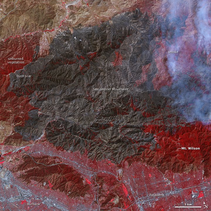
In the aftermath of the fire considerable concern has been expressed about the potential for damaging mudflows in the burnt area, magnified by the current El Nino conditions, which typically bring very heavy rainfall to California at this time of the year.
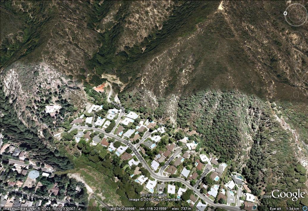
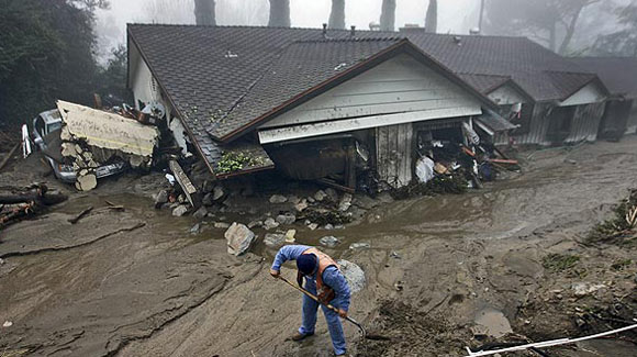
Early on Saturday, unexpected heavy rainfall triggered a series of mudflows from the burnt area that affected the northern part of Oceanview Boulevard in La Canada Flintridge, causing extensive damage to properties but fortunately no fatalities. The most seriously affected area appears to be Manistree Drive, which is shown on this Google Earth image:
 This is apparently the location of this image, from the LA Times:
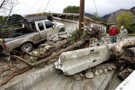
 At least 43 houses were damaged, together with 25 cars (see image below from AP). A dozen houses have reportedly suffered major structural damage.
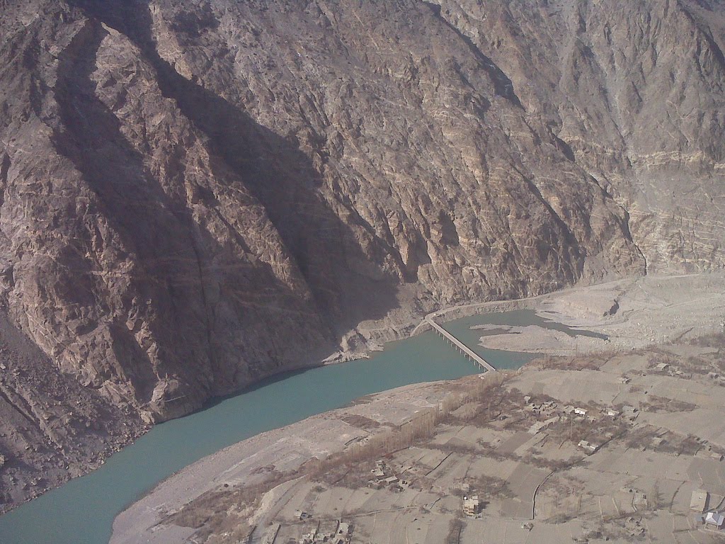
The Attabad landslide – caught between the devil and the deep blue sea
News from the landslide site at Attabad is increasingly grim, despite the ongoing work to create a spillway. The Pamir Times has an excellent article here outlining the impact of the rapidly expanding lake. This lake is now 11 km long and has inundated 460,000 square metres of land, 11 houses and 3.5 km of the Karakoram highway.
However, the spillway that is under construction is a further 79 m above the current lake level, meaning that at its maximum point the lake is expected to inundate 7.55 million square metres of land, including 187 houses, the homes of 1,736 people, and 25 km of the Karakoram Highway. The next problem is expected to occur at the bridge between Shashkat and Gulmit, which the lake has recently reached (see the image below, from the Pamir Times):
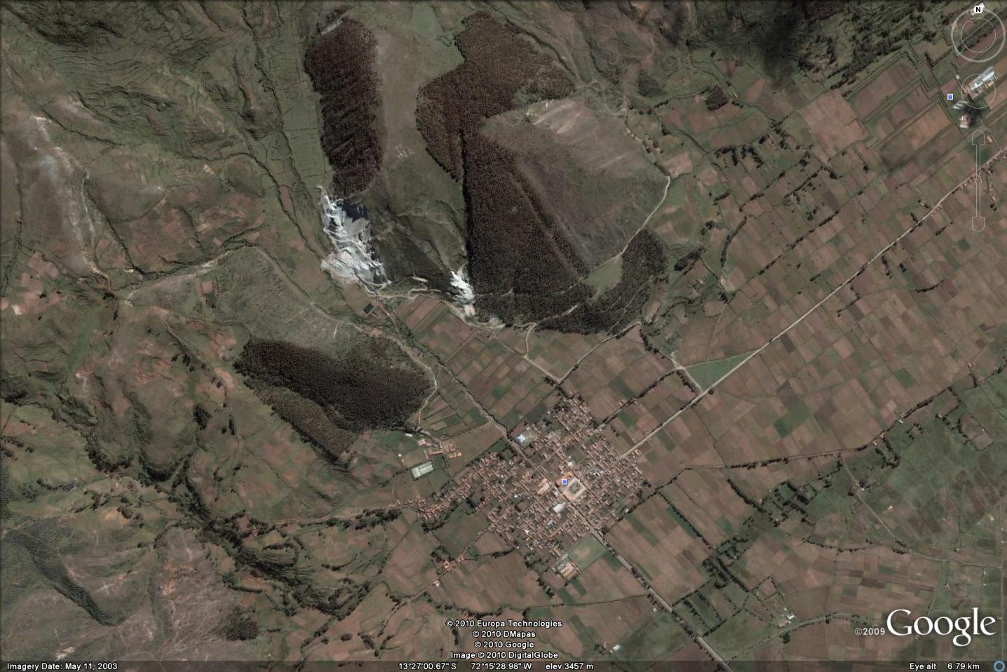
 To give you an idea of the size of the lake – this Google Earth image shows the location of the landslide dam and the bridge (click on the image for a better view in a new window:
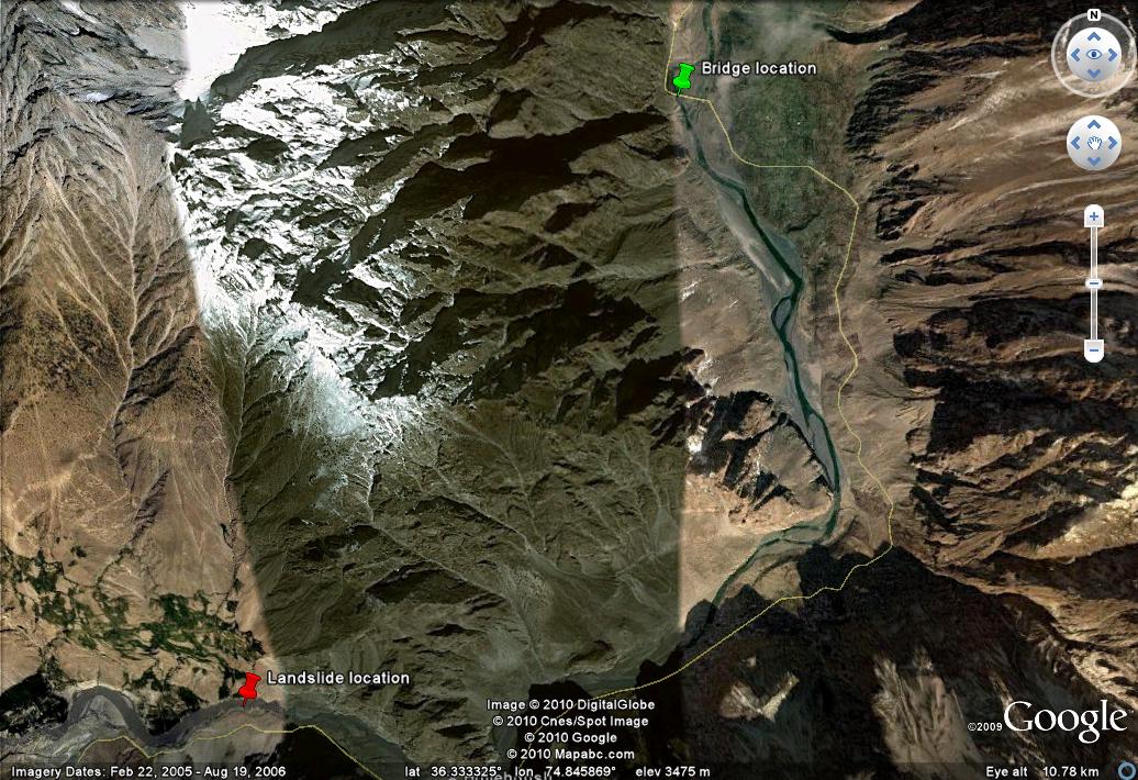
The next crisis will arise when the bridge is inundated as at this point the communities along the Karakoram Highway between the bridge and the dam will be isolated. The Pamir Times article suggests that there are 3000 people in this area, which is probably correct based on the images:

All of this emphasises the magnitude of the problems in this area, which are receiving scant attention from the outside world. When the water reaches the top of the dam it will have flooded a very large area. If the dam remains intact, a huge reconstruction programme will be needed for the Karakoram Highway, and a huge number of people will be displaced. This image shows the location of Hussaini village, which is where the article estimates that the head of the lake will be when the spillway is reached:

On the other hand, if the dam is eroded away then an immense flood will travel down the Hunza River, endangering a very number of people. The 1856 flood caused damage down as far as Attock, which is 360 km away as the crow flies! Unfortunately, the possibility of a sudden collapse of the dam cannot be ruled out as the lake fills.
4 February 2010
The Rivermist subdivision in San Antonio, Texas is on the move again – and it is a rotational retaining wall failure
The woes of the families displaced by the slope failure at the Rivermist Subdivision in San Antonio, Texas have been exacerbated by a new phase of movement. AP Texas News reports that heavy rain has triggered additional cracking of the wall, and the movement of some debris. However, the houses at the top of the slope are apparently not moving.
I have been wondering why they are so confident that the wall won’t fail. In an earlier post I suggested that this is not a simple retaining wall failure, given the toe scarp – a couple of subsequent commenters agreed. These aerial images, from My SA news show that this is the case:
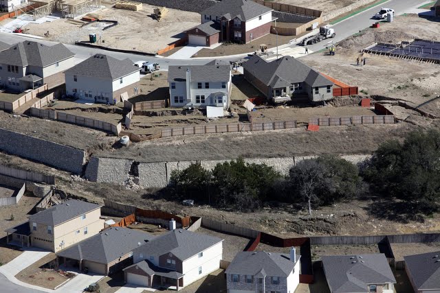
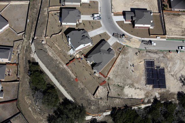
 The key part of the image is actually at the bottom of the first image above, although once you have your eye in you can see these features in the other image too. This is an annotated version of that first image:

This landslide is clearly not a simple retaining wall failure. It is a rotational slip in the slope that has caused the retaining wall to fail. It is not surprising that they do not expect the wall to collapse during these rains as the wall is being rotated to lean backwards by the failure.
Of course, as per the comment below, ensuring that the retaining wall would not be affected by this type of rotational failure should always be a key part of the design process for such structures. I suspect that this will become a textbook example of the problems that can affect retaining walls.
2 February 2010
The causes of the Shiaolin landslide disaster in Taiwan
The Shiaolin landslide disaster in Taiwan, which occurred during typhoon Morakot last August, has been the source of huge controversy. To recap, the landslide, which occurred during an exceptional rainfall event, wiped out Shiaolin village, killing about 500 people. The controversy centred on two key aspects – first, the perceived very slow response of the government to the disaster and second the possibility that tunneling associated with the Zengwen Reservoir project may have been a contributing factor to the slope failure. In response the Executive Yuan of Taiwan commissioned an investigation from the Public Construction Commission, which released its final report yesterday.
The report is of course in Mandarin, but very helpfully there is a powerpoint file available that summarises the findings and provides some illustrations of the key issues. This powerpoint file is available here (warning it is a large file in Powerpoint in pptx format):
http://www.pcc.gov.tw/pccap2/FMGRfrontendDownloadQuoteFile.do?fileCode=F2010020012
The report is available here:
http://www.pcc.gov.tw/pccap2/FMGRfronten/DownloadQuoteFile.do?fileCode=F2010020011
The key finding of the report is in my view correct – this is that the tunnel project was not the cause of this landslide disaster – they factor was the exceptional rainfall experienced in this event. The powerpoint file provides a dramatic illustrations of the magnitude and intensity of this rainfall:
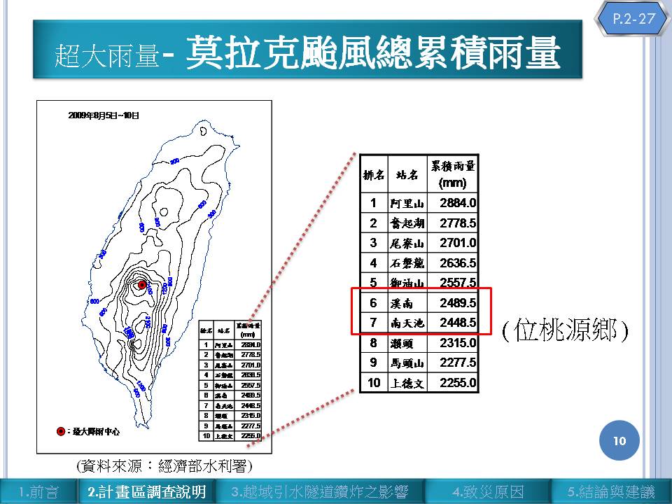
Click on the image for a better view in a new window. The map on the left is the recorded rainfall for the storm, the table on the right is the total rainfall for a number of stations in the worse affected area. Note that the precipitation totals are extreme in every sense of the word – c.2500 mm (2.5 metres of rain) is the equivalent of three years total rainfall for the temperate area in which I live. This is the largest rainfall event ever recorded in Taiwan, and probably the most intense rainfall event worldwide for half a century.
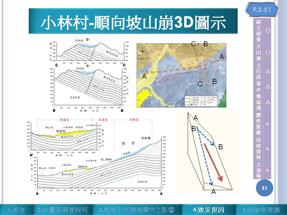
The report shows that disturbance associated with the tunnel is not sufficient to be a factor in the landslide – a conclusion that I support. Instead, they show that the slope underwent a dip slope failure that led to a massive rockslide that destroyed the village. The report suggests that the landslide had a maximum depth of about 86 m and a volume of 2.5 million cubic metres. From what I can tell the slide itself was a wedge failure with a dip-slope defining part of the wedge.
There is only one aspect of the report that continues to cause concern. This is the interpretation of the mechanism of failure. This slide shows a long profile of the landslide site, which shows bedding parallel to the slope right down to the river (section A-A’):
 This just doesn’t seem to accord with what Chris Massey and I observed on site at the toe of the slope:
 This picture is taken from the north end of the toe of the slope looking upstream – note the bedding on the far side of the valley – this is near vertical.
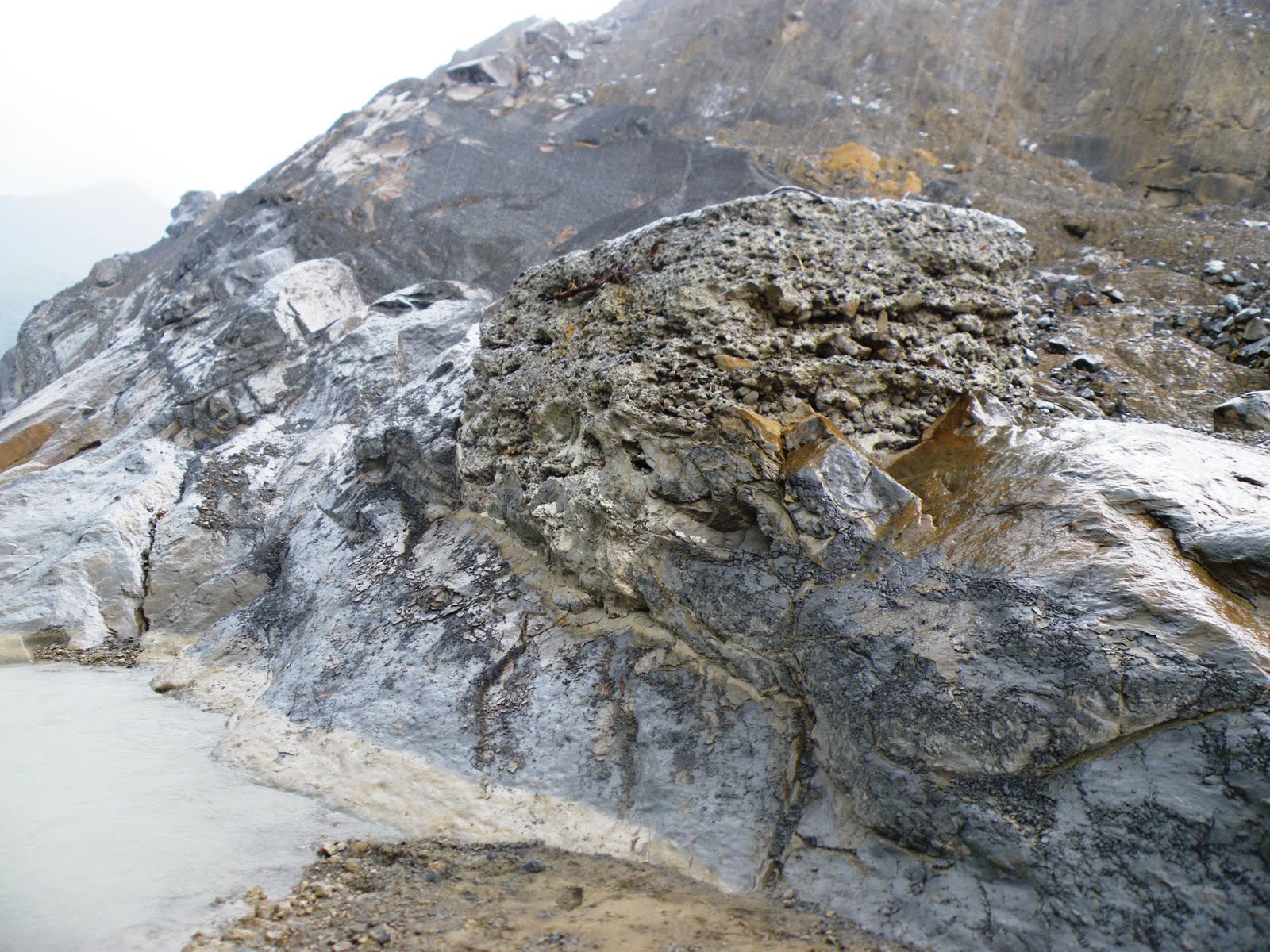 This picture was taken at the site of the old bridge abutment at the toe of the slide (the concrete in the middle of the image is this abutment I think) – again, note the very steeply dipping rocks at this point.
The final point to make is that the Shiaolin landslide was of course not the only failure to occur in the area during Morakot. Mapping of this region has identified 880 landslides covering an area of 2058 hectares (20.88 square kilometres).
There can be no doubt that Morakot was an extraordinary event.
31 January 2010
Latest news from the Attabad landslide in Pakistan
The latest news from the site of the Attabad landslide in Hunza, Pakistan, as relayed by the Pamir Times, is somewhat mixed. There is now a very helpful video of the landslide site on Youtube, which gives a proper view of the slide and its deposit from the scarp area:
The scarp area appears to be highly fractured and unstable.
Meanwhile, this report states that the lake continues to rise as about 2.8 feet (85 cm) per day, which is pretty high. The lake is now 11 km long. Two houses were submerged on Friday, another three will be lost imminently. The helicopter service to the areas upstream has been suspended for two days due to the weather. Interestingly, the article also reports the impact statistics of the landslide itself:
- 19 fatalities plus 6 people missing
- Seven people injured
- 54 houses destroyed
- 60 houses damaged
- 1652 people displaced
- 1.3 km of the Karakoram highway blocked.
On the plus side, the work to create a drainage channel is now well underway. The Pamir Times has printed this image of the site:
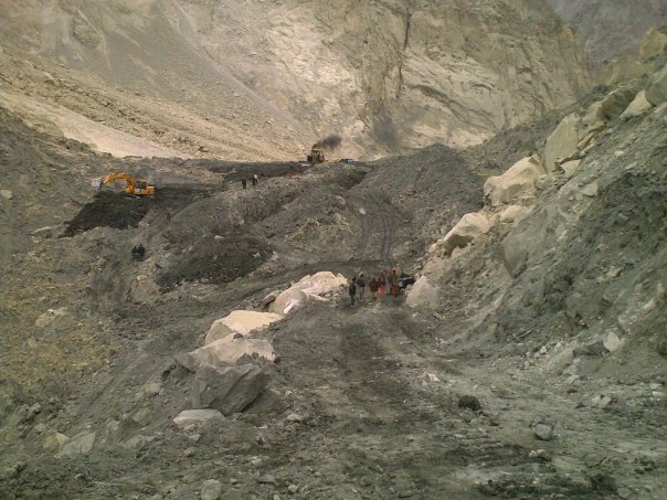 Four excavators are working at the site.
I have two observations to make:
- The along valley thickness of the dam, as shown on the video, should mean that it the chances of failure by piping or slope instability of the dam itself is not high;
- The images all show a dam that is made up of mostly quite fine-grained material, with some blocks. I hope that the core is rather more coarse-grained as preventing rapid erosion of the dam will not be easy if the material is as shown above.
29 January 2010
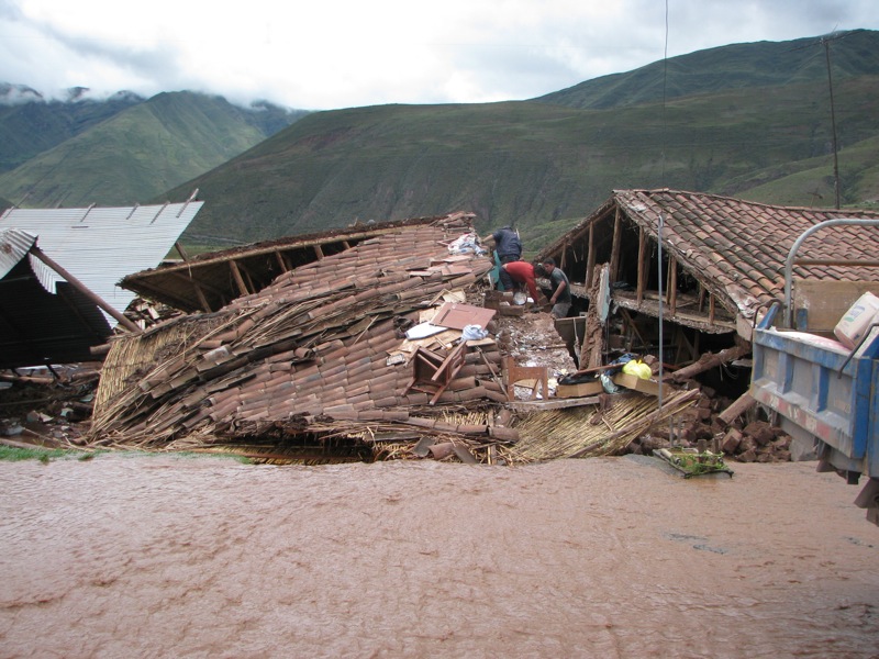
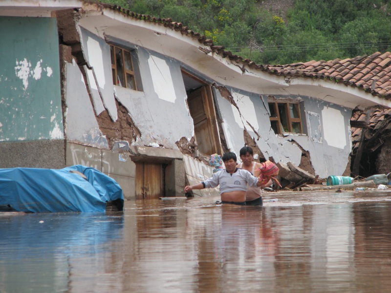
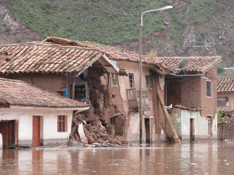
New images of the level of destruction in the Cusco area of Peru
The Spanish language blog El Caminerito has been covering the magnitude of the rainfall, flood and landslide disaster in Cusco, Peru. They have put together a very helpful map showing the locations of serious damage:
Ver Cusco en Emergencia en un mapa más grande
The scale of the disaster, which is still being ignored by the western media in favour of coverage of the tourists at Machu Picchu, is well-illustrated by these images of the Huacarpay region:
Meanwhile, via the Typeboard site, the Spanish language site Peru.com reports that the village of Zurite was severely damaged by a landslide, which sounds to be a debris flow (Google translation):
” the landslide of mud and stones covered the Plaza de Armas, the town’s Church, the main streets of the city and damaged 500 houses. The incident occurred about 3 pm on Thursday after they noticed a crack on a hill and began to take appropriate action, emergency services were able to evacuate the entire population.”
This is the Google Earth imagery of Zurite:
There is no shortage of landslide scars on the hillside above the town, plus the quarries, one of which appears to have excavated out the toe of one of the scars.
Here is an image of the central square via the Panoramio site:
28 January 2010
Earthquake-driven coastal erosion (or a coastal lateral spread) in Haiti
The Discovery Channel has news of a very interesting example of rapid coastal erosion driven by the earthquake in Haiti. The site is at Petit Paradis to the west of Port-au-Prince. Eye-witness reports suggest that the town was struck by a highly localised tsunami in the earthquake, apparently killing 20. This is interesting in part because it is quite likely such a localised event would have been caused by a (submarine?) landslide – not at all unusual in earthquakes. However, the before and after satellite images show the magnitude of the changes on the coastline in this area.
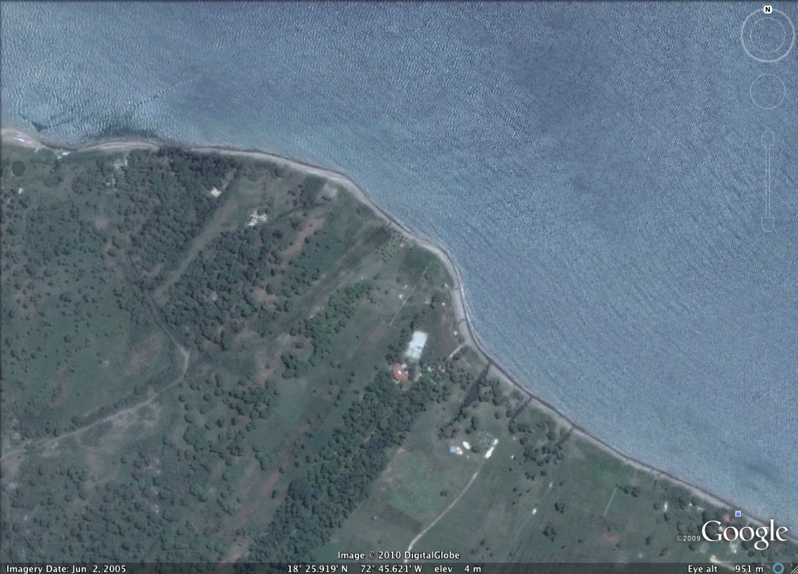
And after:

At first glance the change does not look so dramatic, but take a look at the location of the coastline in the before image in relation to the white building that I have highlighted below:
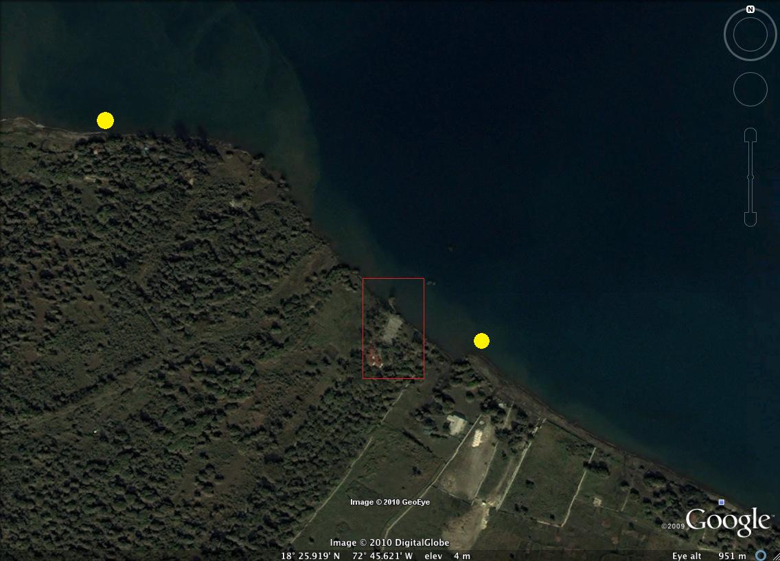
Actually, it is a little more interesting than you might initial suppose. First, note that the section of coast that has “disappeared” lies only between the two yellow dots that I have marked on the image above. To the east and the west the beach is intact. Second, take a look at this CNN video:
http://i.cdn.turner.com/cnn/.element/apps/cvp/3.0/swf/cnn_416x234_embed.swf?context=embed_edition&videoId=world/2010/01/23/watson.paradise.lost.cnn
The key aspect is the picture of that lone tree standing upright in the ocean. A USGS report has suggested this is the site of a lateral spread (the same type of landslide that is evident in the port area of Port-au-Prince), which has caused the coastline to slip into the sea. As lateral spreads are essentially translational, a tree can remain upright. Unfortunately, as the coastline is now no longer protected by a beach, further erosion is likely. An interesting hypothesis is of course that this not-insubstantial slip caused the localised tsunami – or could it be that there was no wave at all, just the appearance of one to those people standing on the land as it slipped below the waves?
27 January 2010
On narrow-minded press coverage
Southern Peru has for the last few days suffered extremely heavy rainfall. The Living in Peru blog reports upon the impact for local people in the province of Urubamba, Cusco. This includes
10 people killed; 2,000 collapsed houses leaving 10,000 people homeless; and crops, cattle and roads swept away. The district of Yucay is isolated due to the floods, the Vilcanota river has broken its banks on both sides, causing many local residents houses to collapse, and the police station has also been swept away.
So how does the international press report on the disaster? Like this from The Times:
Food and water dwindles as backpackers scramble to escape flood-hit Machu Picchu
British backpackers were among 1,500 tourists scrambling today to escape from Peru’s ancient Inca citadel of Machu Picchu, which has been cut off by floods and landslides since the weekend. As food supplies dwindled and hostels ran out of space, many were sleeping in the train station and the town’s main square, fighting for the few seats on rescue helicopters. “The situation is about to erupt,” Rudy Chalco, a tour guide with a group of elderly Europeans, told the Peruvian daily paper El Comercio. “We don’t have any more food, disorder is starting to reign, the soldiers and police that are here don’t know what to do or how to organise the help that has arrived, people are getting desperate and no one is taking charge.” Some tourists were prepared to pay up to $500 (£300) for a seat on one of the rescue helicopters, he said.
And so it goes on for a few more paragraphs. There is not a single mention of the plight of the local people, even though (as the article states) the authorities have declared a state of emergency.
This is the same in news reports in many other newspapers from around the world. Shameful!
 Dave Petley is the Vice-Chancellor of the University of Hull in the United Kingdom. His blog provides commentary and analysis of landslide events occurring worldwide, including the landslides themselves, latest research, and conferences and meetings.
Recent Comments