
25 February 2010
Coastal erosion as art

The Guardian has a slightly bizarre article today. It is entitled “The art of watching your house fall into the sea”. It tells the story of artist Kane Cunningham, who has bought a bungalow on the cliff edge at Knipe Point near to Scarborough. This site has been featured here before as recent landsliding has threatened to destroy a number of houses. He says in the article:
“I’m going to turn the moment my studio collapses into an art work: I’ve set up cameras to film it, and I’ve commissioned music and poetry to celebrate it. Both our houses punch a hole in what we think of as the value of property, and remind us of our moral and ethical responsibility to nature… When my studio disappears, I’ll have no sense of loss – that will be its beautiful final act. The sooner it goes, for me, the better.”
He has a website about this here. Quite bizarre, but it could be very interesting to watch.
24 February 2010
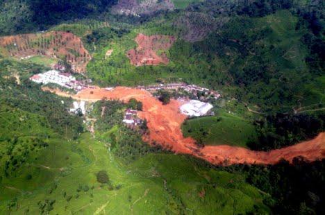
Overview photo of the Bandung landslide
The Jakarta Post has an overview image of the Bandung landslide:
Framlingham College Presentation on the typhoon Morakot disaster in Taiwan
Last night I gave a public lecture on the Typhoon Morakot disaster in Taiwan. The talk may be viewed and downloaded here:
10_02 Framlingham comp
http://www.authorstream.com/player/player.swf?p=332907_634025881557397500
Massive landslide in West Java, Indonesia
A large landslide occurred yesterday in the Dewata tea plantation area in Pasir Jambu, Southern Bandung in West Java, Indonesia, burying the accommodation for temporary plantation workers. It is estimated that 70 people were buried by the slide. This image, from AP, appears to show the head of the landslide, which looks to be a large but comparatively shallow flow type failure in regolith:
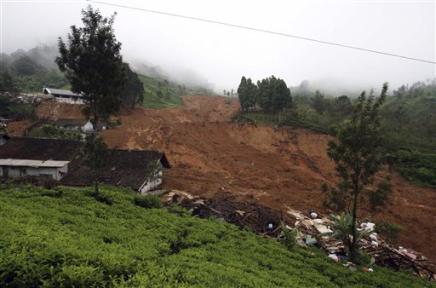
The toe of the slide, including some of the impacted buildings, is shown in this AP image:
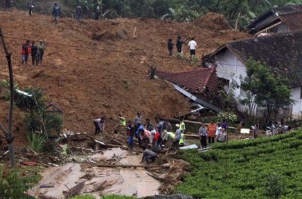
News reports suggest that to date 7 bodies have been recovered from the debris, with rescue operations continuing amongst heavy rainfall, which must place the workers at considerable personal risk.
Java consistently appears in the landslide database with very high fatal landslide occurrence. Tea plantations are also areas of high landslide hazard.
19 February 2010
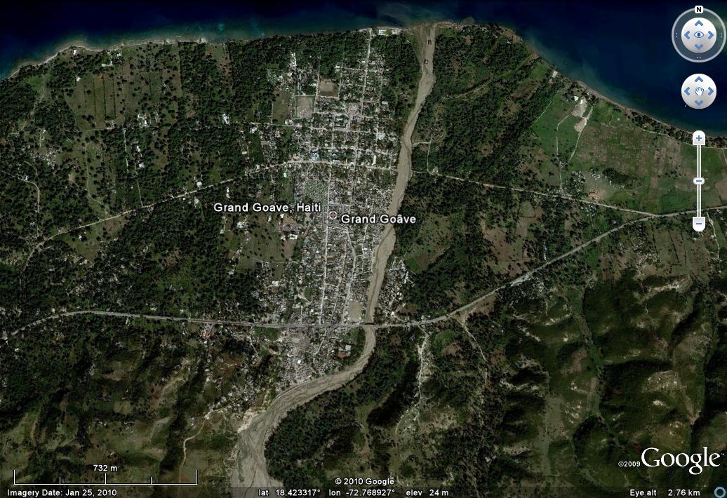
A landslide dam in Haiti caused by the earthquake
Thanks to Lynn Highland for the heads-up on this one. The French language website cyberpresse.ca has an article describing a valley blocking landslide triggered by the Haiti earthquake. The translation says:
“The dam is large and there are still several tens of metres before the water passes over it. The problem is that it has hardly rained since the earthquake of January 12. When the rainy season triggers, a few weeks at most, the water will very quickly here…The dam is located in the mountains about ten miles upstream of Grand Goave, a city wedged between the sea and a semi-circle of mountains that lies ahead.“
This is a Google Earth image of Grand Goave after the earthquake:
18 February 2010
Impressive roadside landslide in Pomona, California
Thanks to reader CConkle for the heads-up on this one. An impressive slide happened this morning by the side of Freeway 10 near to Pamona in California. The slide has completely blocked the road (pictures from the LA Times):
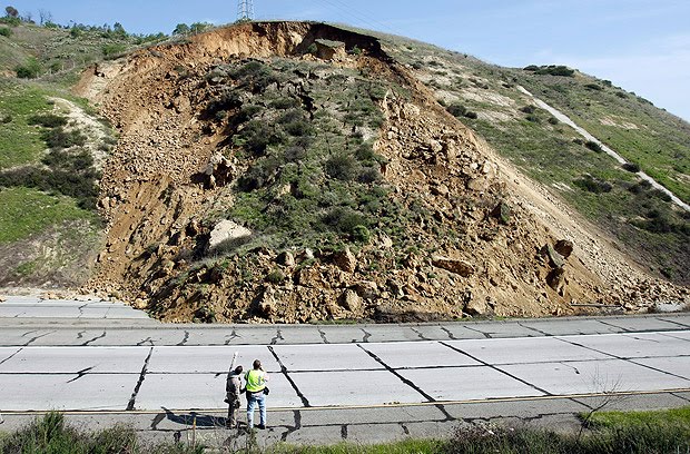
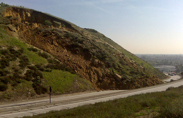
It is uite interesting that the weather does not indicate an obvious trigger for what appears to be a failure on a reprofiled slope. However, California has suffered recent exceptional rainfall in the last few weeks, so it may be progressive failure is the key factor here.
Most recent reports suggest that the slope is still moving and the road is likely to be closed for a week.
16 February 2010
An update on the Italian landslide(s)
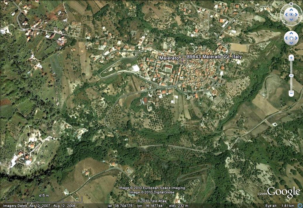
The large landslide in southern Italy that was graphically caught on camera (see the video in my earlier post) has generated a great deal of interest – indeed this site has had its busiest ever day. Details of the slide are still quite sketchy, but this is what we know so far:
First, the media are confusing two different slides in the same general area of Calabria – in fact there were about 100 altogether, but two are directly affecting towns. The one in the video occurred on the outskirts of Maierato, which is this town:
 It appears that the slope had been moving for some days, and there are some indications that it was in distress well before this. The slide appears to have affected the area shown on this image, although I am waiting for clarification of this:
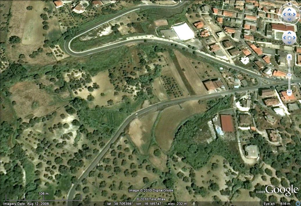 Interestingly, as Jonas van Rutte has pointed out to me, the roads near the headscarp appear to have been recently repaired, judging by the Google Street View images here. No-one was killed or injured in this landslide, although 2300 people have been evacuated from their homes.
The second slide occurred at San Fratello in Sicily, which is this town:
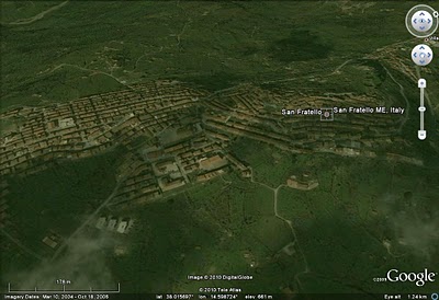 This slide appears to have damaged the centre of the town, leaving 1500 people homeless. The level of damage is high (image from Corriere della Sera):

Watch this! Extraordinary landslide video – Maierato, Italy
The BBC has an extraordinary video of a landslide in Maierato in Southern Italy. More later, but for now the link is here:
http://news.bbc.co.uk/1/hi/world/europe/8517378.stm
UPDATE: Youtube has a longer version of the video below:
http://www.youtube.com/watch?v=j7s2NrEg1Qg
13 February 2010
An analysis of fatal landslides in the Asia-Pacific region for 2006 to 2008
In my last post I published two maps of fatal landslide occurrence in the years 2006 to 2008 inclusive, based upon my long term fatal landslide database. In this post I focus on the Asia Pacific region. This analysis does not include seismically-induced landslides, most notably the Wenchuan (Sichuan) earthquake, which triggered a large number of slides, killing over 20,000 people.
The basic statistics of the data are in the table below – as per usual you can get a better version of the table and figures by clicking on the image:
 In total, I recorded 796 fatal landslides (note that in this context I use landslides generically to include all non-avalanche mass movements, including rockfalls) in which 9941 people were killed. In terms of fatalities, the Philippines ranks highest (Fig. 1), although India is the country with the most fatal landslides (Fig. 2). Of course if the Wenchuan earthquake were included China would be the top of both lists
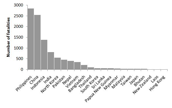 Fig. 1: The number of recorded fatalities organised by country
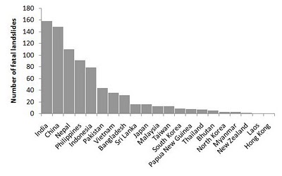 Fig. 2: The number of recorded fatal landslides organised by country
The seasonality of landslide occurrence varies greatly within this area. In South Asia there is a very strong influence from the S. Asian monsoon, which is very apparent in the monthly data (note that for these three graphs I have used the same y-axis scales so that they are directly comparable):
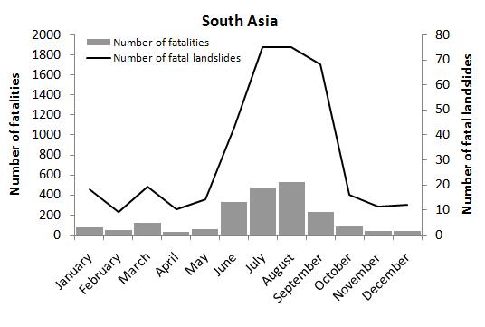 Fig. 3: Monthly recorded fatal landslide occurrence (line graph) and loss of life (bar graph) for South Asia
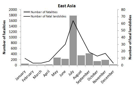 Fig. 4: Monthly recorded fatal landslide occurrence (line graph) and loss of life (bar graph) for East Asia
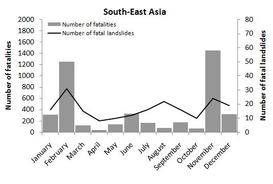 Fig. 5: Monthly recorded fatal landslide occurrence (line graph) and loss of life (bar graph) for South-East Asia
As with yesterday’s post, I have no problem with this information being used elsewhere, but please reference the figures and information as follows:
Petley, D.N. 2010. An analysis of fatal landslides in the Asia-Pacific region for 2006 to 2008. Dave’s Landslide Blog URL: http://daveslandslideblog.blogspot.com/2010/02/analysis-of-fatal-landslides-in-asia.html
12 February 2010
Maps of global fatal landslides
NB there is an alaysis of the data in thiese maps in this post:
http://daveslandslideblog.blogspot.com/2010/02/analysis-of-fatal-landslides-in-asia.html
I have recently worked up two new maps of the distribution of fatal landslides, based upon the fatal landslide database that I maintain. This first map shows the global distribution of non-seismic landslides for the period 2006-2008. Each dot represents a single fatal landslide. The colours indicate the year:
Red = 2008
Blue = 2007
Green = 2006
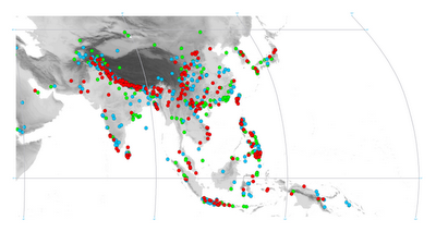
The background image is the ETOPO digital elevation model, with the darker colours indicating higher ground (click on the image for a better view in a new window):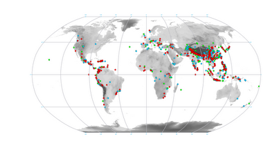 There are a whole host of interesting aspects of this map. First, note the clustering of the landslides in areas that are tectonically-active (e.g. Western S. America, the Himalayas, Indonesia, etc). Second, note how the patterns change from year to year (e.g. take a look at the south coast of China – this is related to typhoon landfalls). Finally, note that the vast majority of recorded fatal landslides occur in Asia. This is shown better by the second map, for Asia only:
 Please feel free to use the information and figures on websites, reports, theses etc, but please reference this as follows:
Petley, D.N. 2010. An analysis of fatal landslides in the Asia-Pacific region for 2006 to 2008. Dave’s Landslide Blog URL: http://daveslandslideblog.blogspot.com/2010/02/analysis-of-fatal-landslides-in-asia.html
 Dave Petley is the Vice-Chancellor of the University of Hull in the United Kingdom. His blog provides commentary and analysis of landslide events occurring worldwide, including the landslides themselves, latest research, and conferences and meetings.
Recent Comments