
26 January 2010
The San Antonio retaining wall collapse – did the developer have a permit?
Reports suggest that ground movement has ceased in the Rivermist subdivision, which suffered a fairly spectacular retaining wall failure over the last few days. Attention is now focussing upon that retaining wall – and in particular on why it failed. This is a pretty key issue given the potential liabilities and its magnitude – the wall is 1000 feet (>300 m long).
Press reports note two interesting aspects of this accident:
- The City of San Antonio has released a statement that says “The hillside collapse yesterday within the River Mist subdivision that damaged several homes was a result of an improperly constructed retaining wall, as well as improper compaction of fill on which homes were constructed by the developer, Pulte Homes. The developer did not obtain the required City construction permits for the retaining wall that collapsed.”
- Some reports suggest that this is the second time a retaining wall has failed at this site: “One neighbor who was among the first homebuyers in the subdivision set among rolling hills on the outskirts of San Antonio said he was initially told no homes would be built on the crumbling ridge because it was too steep. Romeo Peart, 32, said one retaining wall failed several years ago before the current one was built and homes were constructed above it” (Washington Post).
I should also add that I am not sure that this is a particularly simple retaining wall failure, based upon the image below (from here):
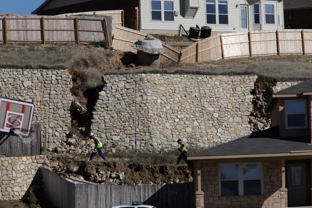 In particular, it appears that the slope / small retaining wall below where the man in the green jacket and hat is located has also failed. I wonder why?
Finally, I thought I’d embed this video, at least in part for the picture shown before the video starts, which is a somewhat surprising image in my opinion:
http://www.kens5.com/v/?i=82656182
The video itself provides an interesting overview and a verification that a section of the wall had needed rebuilding on a previous occasion.
Fatal rockfall near to Munich in Germany
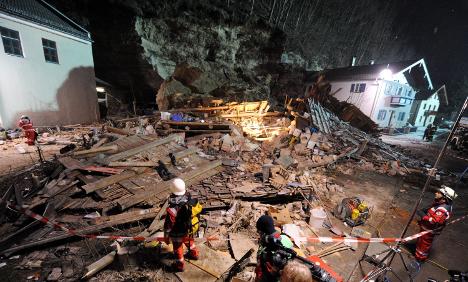
Last night a fatal rockfall occurred at Stein an der Traun in Southern Bavaria. According to this report, which is also the source of the remarkable image above, the block was the “size of a house” (probably something of an over-estimate), falling from the 15 m slope behind the building. There were four people in the house at the time, of which two were killed and two were injured. There is no obvious trigger for the failure.
It is of course too early to speculate about the causes of this sad accident, but in my experience the combination of an unfortunately-orientated discontinuity in the rock (often a joint) and cutting of the toe of the slope to create space for the building are often to blame. It will be interesting to find out what caused this accident.
25 January 2010
Ongoing massive retaining wall failure in San Antonio, Texas, USA
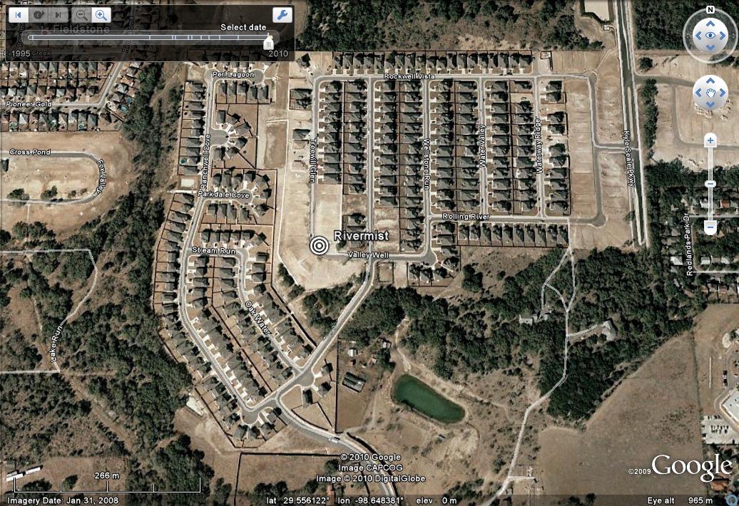
In the United States there is an interesting developing story about a large-scale retaining wall failure that is causing the collapse of a housing estate in San Antonio, Texas. The housing development, called the Rivermist subdivision, is the one shown in the Google Earth image below. It is still under construction. The marker shows the approximate location of the slide, as far as I can tell:
According to the media reports the slide started moving on about Friday is now sliding at about 4 inches (10 cm) per hour. There is a pretty clear video of the slide here (but note that this is definitely not a sinkhole as the report suggests).
The slide is far from trivial. These images, from this site, appear to have been taken a day or so ago:


More recent reports and images suggest that the slide has moved a great deal since these pictures were taken. More than 80 houses have been evacuated.
The area of the failure is, as far as I can tell, shown on this Google Earth image. This is two years old and was taken before the houses in this area were built. I have highlighted a rather peculiar feature that runs across the road on this image:
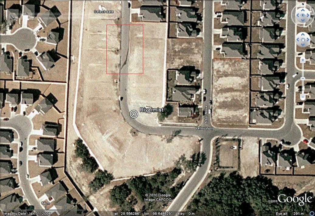 Interesting! The worst-affected houses in this area already look beyond recovery. I wonder how many more will be affected. Personally, I would not allow people to stand or to wander around anywhere near the toe of that wall, but maybe I am overly-cautious. This is clearly a tragedy for the families involved.
Continuing concerns about the landslide dam at Attabad in Hunza, Pakistan
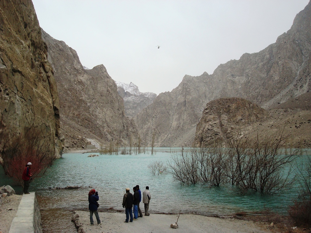
The Pamir Times continues to provide excellent coverage of the state of the landslide dam at Attabad in Hunza, N. Pakistan (see earlier posts here, here, here and here). First, they have posted another remarkable image of the landslide in action:
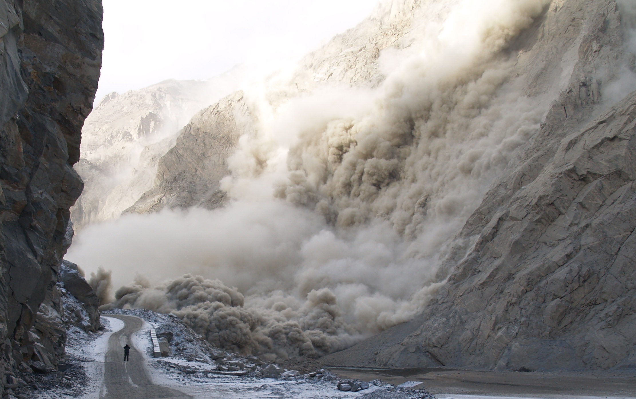 Second they have provided various reports on the state of the efforts to mitigate the rising water level and to reopen the highway. It is clear that the road remains blocked, which must be creating incredible hardship in the valley upstream of the slide. It appears that the Chinese engineers who are planning to reopen the road have only just arrived on site. Promisingly, the report states that another group of Chinese engineers have arrived to attempt to drain the lake, presumably working with the Pakistan Army. One can only hope that these are the same group that performed extraordinary Tangjiashan barrier lake drainage operation.
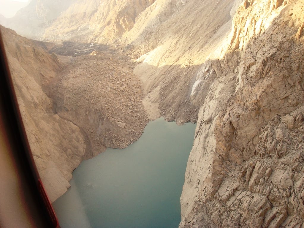
The magnitude of the task is well-illustrated by this report, also from the Pamir Times. The lake is now 8.9 metres long and is filling at a rate of about 3.6 feet (1.1 metres) per day. The Pakistan Army has promised to release the water within 45 days. The images show the nature of the problem even more clearly. This image, taken from a helicopter, shows the landslide dam deposit:
It is clear that the the lake is now rising quite rapidly towards the natural spillway. This image shows the size of the lake itself:
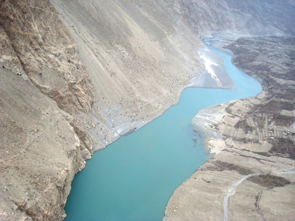 It is clear that the water is now starting to encroach onto farmland in a serious way. Finally, this image shows the state of the lake on the ground:

24 January 2010
New, remarkable animation video of the Po Shan Road landslide in Hong Kong
Thanks to David Kwok of the Geotechnical Engineering Office in Hong Kong for highlighting this video to me, and for the image below.
On 18th June 1972 Hong Kong suffered an extraordinary landslide at Po Shan Road, in the Mid-Levels area:
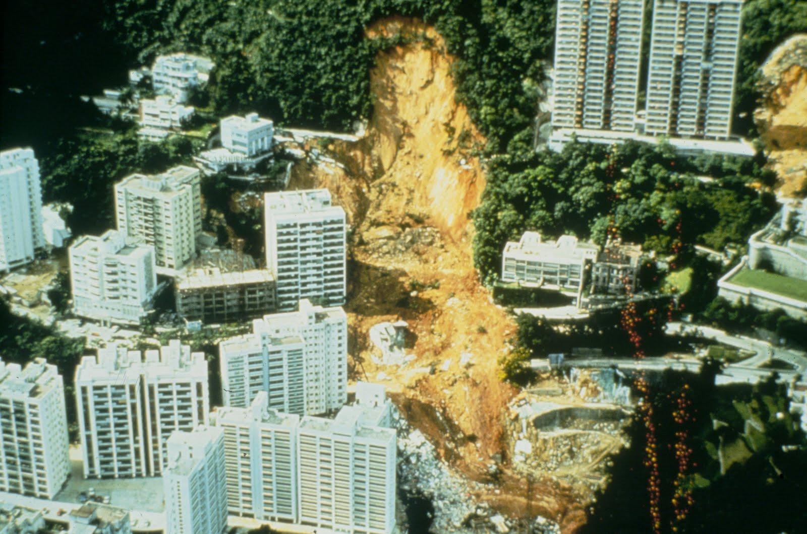
The slide, which had a volume of about 40,000 cubic metres, induced the collapse of two large buildings, killing 67 people and injuring a further 20. The landslide understandably caused considerably soul-searching within Hong Kong, not least because major stability problems at the site had been identified nine months before the failure. A recommendation of the Royal Commission (Hong Kong was a British dependency at that time of course) was that a government agency should be established to manage slopes. This led to the formation of what is now called the Geotechnical Engineering Office (GEO), which has worked tirelessly and with considerable success to reduce landslide losses in Hong Kong.
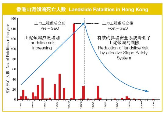
In 2007 as part of its 30th anniversary celebrations, GEO produced this brochure. Much more information about their work, and about slope issues in Hong Kong, can be found on their slope safety website. There is little doubt that the approach has been successful (and should be repeated elsewhere – for example in Taiwan). This graph, taken from the brochure above, shows the trends in landslide losses before and after the establishment of GEO:
However, through all of their work they have not forgotten the importance of the Po Shan Road incident. Recently, they have produced a short video describing the event. Most interesting is a set of animations of the occurrence of the landslide, including its impact on the buildings. This is an impressive and useful illustration of the destructive power of even comparatively small landslides when they occur in urbanised areas, and of the need to maintain vigilance.
The video is available from the GEO download site at the following address:
http://hkss.cedd.gov.hk/hkss/eng/download/poshan_incident_english.wmv
I have embedded the video here – you should be able to play it by clicking on the video screen below:
http://www.youtube.com/get_player
Do take a look – it is well worth it – and download the original from the GEO download site.
21 January 2010
More on the earthquake damage to Haiti port
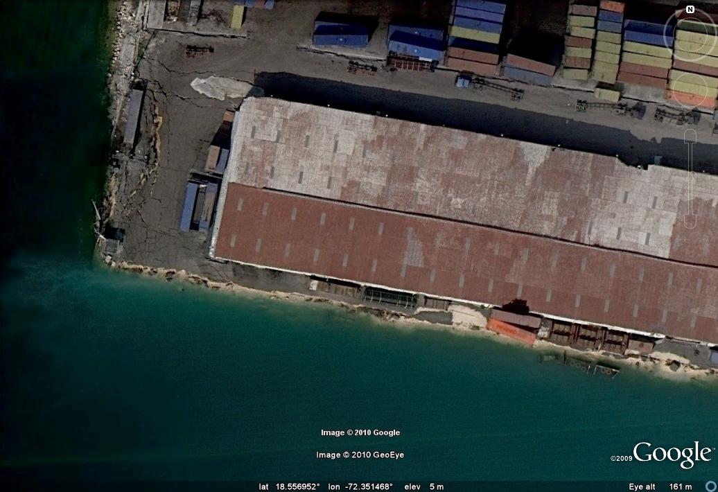
Google have now released an even higher resolution set of satellite images of Port-au-Prince, this time collected using the IKONOS instrument. These images have an extraordinary level of resolution – about 15 cm – meaning that the images are spectacular. This allows us to get a better understanding of the liquefaction damage at the port, the subject of my earlier post. So, this is a close up of the damage to the main container wharf, with the crane in the water:
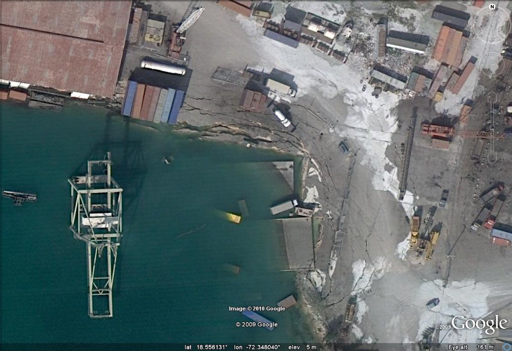
It is pretty clear from this that the dock support has failed and the deck has slipped into the water, taking the crane with it. That will not be at all easy to clear. Further along the wharf the scale of the liquefaction damage is pretty clear:
Perhaps the most surprising thing is the lack of effort going into re-opening the port. This is a good illustration of just how difficult it has been to get the aid operation underway in Haiti.
Reports of landslides in the rural earthquake-affected areas of Haiti
As the Haiti disaster moves from the rescue phase into stabilisation and the initial component of recovery, the media are running out of miracle survival stories and tales of looting. This means that they are now looking for other stories to tell, and in particular are starting to focus on both the plight of communities outside of Port-au-Prince and on detailed eye-witness accounts. Interestingly, this is starting to suggest that although the number of landslides is smaller than we might have expected, in the upland areas they have caused some problems. So for example, Sphere reports about the road to Jacmel, based upon the account of David Belle from the Cine Institute in Jacmel:
“Belle was finally able to drive from Port-au-Prince to Jacmel on Tuesday morning. “The drive over was very alarming. The town of Leogane is very badly hit; the small mountain communities are badly hit from landslides, homes taken out by dirt,” he said. The film school plans on expanding its reporting to neighboring towns soon, to make sure they also get the help they need.”
Meanwhile, Reuters reports about the upland areas close to the epicentre:
“Two hours drive west of Port-au-Prince, in the banana-growing hills where the epicenter of Haiti’s earthquake tore chunks out of hillsides, hurled boulders and cracked roads, survivors with festering wounds sleep by their wrecked homes, unseen by aid workers...
By Tuesday, foreign medics were finally at work at a field hospital at the dirt-poor farming town of Leogane, by the quake epicenter. But nobody in the rock fall-plagued hilltop hamlets seems to know they are there, and the medics do not have the personnel to send teams out to look for patients.
Here at the core of the violent 7.0 magnitude quake, lush green hills have been ruptured and split. Locals have sawn through trees sticking out of fallen earth on the roads and they point to where truck drivers at a sand quarry were crushed when a giant chunk of it collapsed, redrawing the landscape. “I was inside bathing when it started shaking. I ran out and I saw that where there had been a hill there was empty space,” said Seraphin Sonel, 14, who lives by the destroyed quarry.
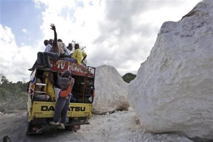
Finally, AP has this image of the aftermath of rockfalls on the road to Jacnel:
Meanwhile, images are also starting to appear of the damage to shanty towns, such as this one, also from AP:
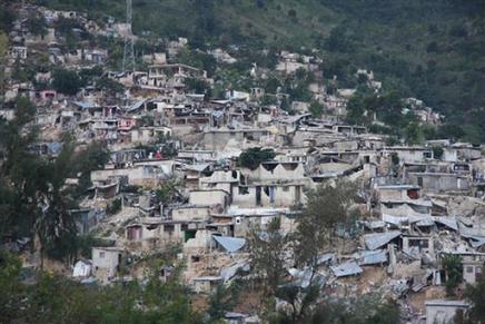
It is clear from this image that, unsurprisingly, some of the damage in these poor areas has been caused by shallow slips under the houses. This does not bode well for the rainy season.
19 January 2010
Landslides from the Haiti earthquake – not many!
NASA has today released an image, partly obscured by cloud, of the upland area to the south of Port-au-Prince. This is the area that received the highest levels of shaking and, given the terrain, was most likely to have suffered slides. The image is available here:
http://photojournal.jpl.nasa.gov/catalog/PIA12495
and a comparison with an image taken in 2008 is here:
http://earthobservatory.nasa.gov/IOTD/view.php?id=42333
Note that this area suffered heavy rainfall in the 2008 hurricane season.
This is a close-up of a part of the area, close to, and just to the south of, the fault:
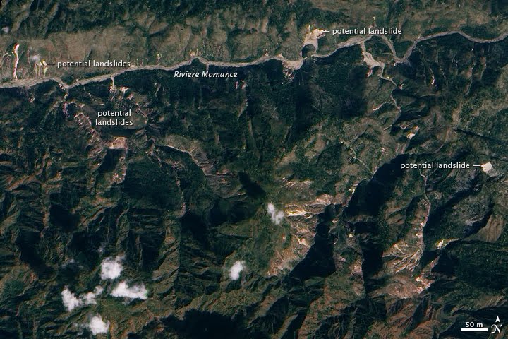 Clearly there are landslides visible, but the number is comparatively low and for the most part the slides are small. Note that NASA has, understandably, marked them as being “potential landslides”. The terminology used here might be interpreted as indicating the possible existance of a landslide, rather than an area in which a future landslide may occur. The big unknown is whether there is a higher likelihood of sliding in the next heavy rainfall event. This can only be addressed with fieldwork, but I am not sure who will do this (maybe the USGS?). It is also essential that refugee camps are located away from potential mudflow and debris flow tracks (the worse structure to be in during a debris flow is a tent – they offer no protection, but the ropes and pegs make rapid escape difficult). I hope that this will be taken into account as the situation stabilises.
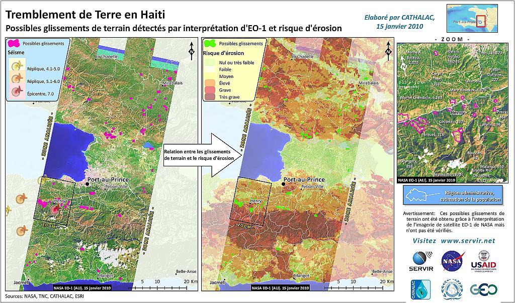
Finally, servir.net has produced an erosion potential map for the earthquake-affected area, which is available here:
18 January 2010
Haiti Earthquake – video of the liquefaction damage to the main dockyard in Port-au-Prince
Following up on my post yesterday on the nature of the liquefaction damage to the main container port in Port-au-Prince, CNN has a video from the site. The video is here:
http://edition.cnn.com/2010/WORLD/americas/01/15/haiti.harbor/index.html
The recording appears to have been shot in this area (this is the post earthquake Google Geoeye imagery):

The video clearly shows the liquefaction features, the collapsed wharves and the damaged cranes and notes how much work is needed to reinstate all of this. There is no sign on the video that this work has started.
Very small earthquake kills seven in landslides in China
AFP is reporting that an earthquake struck Guanling, Zhenfeng and Zhenning districts in Guizhou province at 09:35 UT yesterday (Sunday), triggering two landslides that have killed seven people and left one person missing. Other news agencies are reporting that one of the landslides struck a boat on a river.
The peculiar thing about this is that the earthquake appears to have been very small indeed. The USGS does not have a report of the event on its global earthquake web site, meaning that it presumably did not reach their minimum size threshold. The Chinese Earthquake Administration report is here. This confirms the occurrence of the two landslides and the seven fatalities, but also notes that the earthquake had a magnitude of just 3.4 (local magnitude ML=4.0) and a depth of 7 km. This is an usually small earthquake to trigger landslides.
 Dave Petley is the Vice-Chancellor of the University of Hull in the United Kingdom. His blog provides commentary and analysis of landslide events occurring worldwide, including the landslides themselves, latest research, and conferences and meetings.
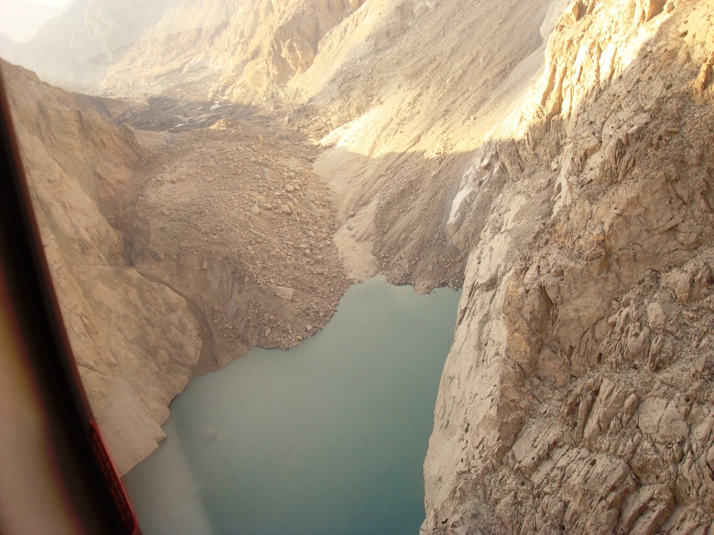
Recent Comments